Monday, 22 March 2021

Whitchurch, Laverstoke & Freefolk


Whitchurch Silk Mill

An exploration of Whitchurch and the river Test with my friend Merv. We started from the railway station and walked downhill to find the town centre. A little further along was the Silk Mill, the only one of the remaining mills which is still functioning. It was founded in 1800.

With the mill behind us there was a nice view of the mill pool and the River Test passing under a shallow bridge.

This was the view looking from the bridge. A good number of trout, some quite large, could be seen in the clear water.

We partially retrace our steps and walked past the town school to find a path following the line of the river to the east. We passed a former mill with with an imposing water wheel ...

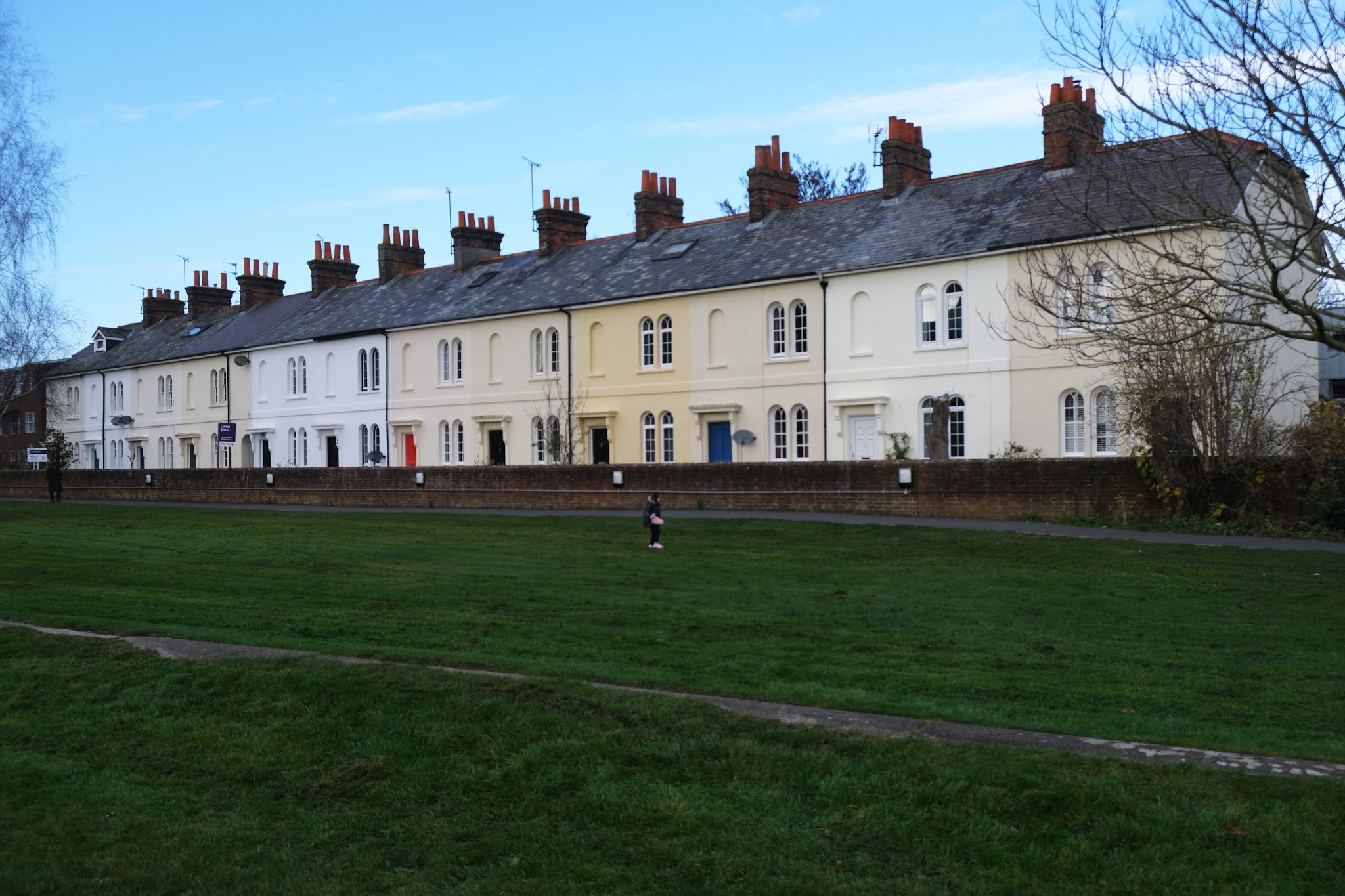
... and followed open land, with the river to our left, to reach the village of Laverstoke. We were very struck by this group of houses and then had an amusing moment with some secondary school boys who were completely astonished by the idea of my taking a photograph of the houses. They simply couldn't comprehend why anybody would do such a thing.

At the end of this road (Laverstoke Lane) we turned left into London Road and passed the former Laverstoke Paper Mill. It turns out that the houses were built in the early 20th century for the mill workers. The quality of construction and spaciousness, which were what caught our eye, reflected the philanthropic ideas of the land owners, the Portal family.

We headed across fields towards the intriguingly named Freefolk. Its name is thought to indicated a free settlement outside the feudal system. St Nicholas church was founded in 1265, but it now has an 18th century look.

A path across further fields brought us to the handsomely restored and extended Bere Mill, dating from the 18th century. 25 years ago it was apparently close to dereliction. There was a nice view from the road bridge.

We continued along the road and turned left to pass the mill again over to our left. We noticed this intriguing sculpture on the way past.

We followed a path with the river on our left and as we returned to Whitchurch we spotted another mill, now converted into a house.

We found a narrow and steep path to take us towards main road and the station and were surprised to spot this red brick pill box overlooking the road. There are still a surprising number of these along the Kennet, but they are all concrete.

Conditions: a pleasant sunny day.

Distance: about six miles.

Map: Explorer 144 (Basingstoke, Alton & Whitchurch) and the Whitchurch Walks website. I would have to say that the walk leaflet, although interesting and very nicely presented, was not easy to follow, as the diagram was very small.

Rating: four stars.

Friday, 19 March 2021

Great Bedwyn and St Katherine's church

Cottages in Frog Lane

Today's walk started in Great Bedwyn. We parked by the canal and headed into the village passing the wonderful cottages in Frog Lane. Crossing the canal, we noticed how many barges were moored along it.


We walked through the village and turned right at the pub and walked along the road to reach this thatched house which was being - well what?

We turned left here and walked across a field to enter Chisbury Woods. The walk instructions gave us impeccable guidance through the numerous paths. We passed an isolated house and find the right route across a large field, turning left down a lane to reach Chisbury Lane dairy farm. The old farm house has a plaque in the gable with the date 1629. This handsome building seems to be just one room thick. Our walk description indicates that this was a Long House.

We continued along the road and passed another fine long house on the left.

Soon after this we turn entered Bedwyn Common, which seemed rather misnamed - it was surely a wood!

We followed the main path through the wood to reach the Savernake Road and turn sharp left to find our way to St Katherine's church, just outside Savernake Forest.

The church was built for the Marchioness of Ailesbury by TH Wyatt in 1861. So, an estate church. It is cruciform with the tower tucked in the corner between the nave and the transept. The inside is apparenly very impressive, but of course the church is closed at present.

We followed the path back towards Great Bedwyn, gradually realising that we had come from Great Bedwyn in the opposite direction in an earlier walk. We eventually emerged opposite St Mary's church and walked through the village down to the canalside car park.

Conditions: rather grey.

Distance: 5 miles.

From: Savernake Forest from Great Bedwyn (Fancy Free Walks).

Map:  Explorer 157 (Marlborough & Savernake Forest)

Rating: three stars.

Monday, 15 March 2021

Yattenden and Ashampstead

 Yattendon

A relatively local walk with my friend Merv. Ange and I did a version of this walk last May, but in the reverse direction. We parked (separately) in the car park at Yattendon and headed north skirting the centre of the village with the the Pump House (now a bus shelter) on the left which was the work of the great Victorian architect, Alfred Waterhouse. Behind it can be seen the Royal Oak pub, closed now of course but said to have a very good restaurant.

We quickly left the village and headed along muddy field-edge tracks, all part of the Yattendon Estate. The fields are all staggeringly large. We eventually reached a road junction with the B4009 and admired the line of trees which leads along the lane towards Ashampstead.


We didn't follow this lane but instead headed north east through a more wooded area to reach Ashampstead Green. We turn right and reached the edge of Ashampstead where I was delighted to see this delightful red brick tower nestling in someone's back garden. I spotted a similar structure nearby on the previous walk.

 We walked along the road to pass the 13th century church of St Clement. It is currently closed, of course, which is frustrating as it has the most complete set of medieval wall paintings in Berkshire.

We were intrigued by this large house nearby and spent some minutes trying to analyse it. We thought that the pebbledash part was the original and the red brick part rather later and we were intrigued by the dormers which has been bricked in.

We continued southwards along the lane and then took a right to walk along an area of abandined farm buildings. We walked along the edges of several large fields (back in the Yattendon Estate) and emerged through an area of woodland to reach the church. The church of St Peter and St Paul dates from about 1450.


I was quite taken by a rambling house on the other side of the road. Walking away from this house brought us back to the village centre.

Conditions: grey, but at least the threatened rain didn't materialise.

Map: Explorer 158 (Newbury & Hungerford)

Distance: just over 5 miles

Rating: three stars. It was good to get out in the open country.

Wednesday, 10 February 2021

Shaw


Shaw House

A nice walk from home to Shaw House and back. We walked into Newbury and along the Kennet and Avon canal to reach Victoria Park.

Walking across the Park we came to the Victoria memorial. I discovered on a previous walk around the town that the statue and lions were originally were originally located in the Market Place but removed in 1933 and put into storage. It was installed in its present site in 1966. I noticed today that the lions consist of two parts - you can see a line across their backs. Presumably they were cut down for storage.

Emerging along a passageway to reach London Road, we looked left towards the interesting Roman Catholic church of St Joseph. It dates only from 1927-8. Pevsner describes it as being "Early Christian or Byzantine or Italian Romanesque" with a high campanile in a Free Renaissance design.

Crossing the busy road junction by an underpass we continued along Shaw Road with the rather pleasing Smith's Crescent of 1823 on the right.


The terrace is punctuated by a single archway with, to the right, the only house in the terrace which has bay windows.

At the end we passed a former mill, which we had never previously noticed.

We turned left into Church Road and soon, on the right, we reached Shaw House. It was built in 1579-81 for Thomas Dolman and remained in his family until the early 18th century. It changed hands several times after that, becoming a school in 1943 and was renovated in 2005-8 to take on its current role as a Register Office, meeting place and visitor attraction.

Continuing along Church Lane we came to St Mary's church, rebuilt in 1841-2 in a neo-Norman style, which jars with the Romanesque tower. The chancel, by William Butterfield, with 13th century style tracery offers another discordant element.

At the end of the lane we turned right effectively doubling back alongside a stream. There was a pleasant view back from a bridge and the surprising sight of a lone angler landing what looked like a trout of 2 or 3 pounds.

We headed along a footpath towards Smith's Terrace and enjoyed a sight of the first snow drops of the year.

We now retraced our steps across Victoria Park to reach Newbury Bridge (1769-1772).

Finally, in Enborne Road we noticed this memorial to Protestant Martyrs.


Conditions: pleasant with some sun.

Distance:  Perhaps four miles in all.

Rating: four stars. A very interesting and varied walk.

Saturday, 23 January 2021

Donnington Castle


                                                                             Donnington Castle 

We have been trying to get into the habit of doing regular walks around Newbury. Recently we were half way through a circular walk heading downhill along Wendan Road. We were struck by the sudden appearance of Donnington Castle on high ground to the north of the town. It struck us that we could vary our walking by doing a walk from home to Donnington and back - about 5 miles.

We set off from home and headed for the Kennet and Avon Canal, crossing the Monkey Bridge into Northcroft Park. We then followed the left hand edge of Goldwell Park to emerge onto Speen Lane. Now we followed the Old Bath Road for a short way to reach Bath Road. It reminded us of how we nearly bought a house here - and how glad we were that instead we bought the house we now live in!

We turned right into Brummell Road and right at the end into Grove Road. This brought us to the entrance to Donnington Grove, where we uncharacteristically ignore a no right of way sign to follow the tarmaced road through the golf course to reach a bridge over a large lake which is part of the River Enborne.


Over to the right was an attractive small folly.


We crossed the bridge and had a distant view of the hotel. We climbed uphill - a somewhat muddy climb - and passed the Donnington Almshouses to climb towards the ruins of the Castle. This was our first, sideways on, view of the Gatehouse, which is really all that remains.

The Castle was built by Sir Richard Abberbury in 1386, but was sold 12 years later to Thomas Chaucer (son of Geoffrey Chaucer). Chaucer's daughter Alice married the Duke of Suffolk. Suffolk fell out with Henry VII and the castle became a royal property. It fell into decay soon after. In 1643, when the Civil War broke out it was captured by the Royalists and its defences were improved. After an 18 months' siege by the Parliamentarians which began in 1644, the garrison surrendered. In 1646 Parliament voted to demolish the castle and only the gatehouse was left standing, although the outline of the defensive walls can still be made out.

The front-on view is more imposing (see the photo at the top of this post).

And this is the view of the Gatehouse from behind, which gives some sense of the Castle's original scale.


Conditions: wonderful sunshine.

Distance: about 5 miles.

Thursday, 3 December 2020

Newbury

                                                             St Bartholomew's Hospital

It is almost three years since we moved to Newbury and I thought it would be a nice idea to post a blog about the town. I started my route at St Bartholomew's Hospital, founded in the early 13th century possibly by King John. A number of other almshouses can be found in Argyle Street and elsewhere in the town.

From the top end of Argyle St I went up Newtown Road to admire these grand Italianate mansions of circa 1869-70. Pevsner suggests that this was a stalled villa development.


Now along Portchester Road to head towards Newbury Racecourse where you are greeted by this unusual and mysterious sculpture.


Horse racing first took place here in 1905, although other locations in the area had been used for a hundred years before.

I retraced my steps to cross the railway and head towards the town centre along Cheap Street. On the right was the former Public Library, latterly a Prezzo restaurant and now empty like the Post Office further along the road. The building has the distinction of having been funded by the philanthropist Andrew Carnegie.

Just before reaching the Market Place I felt I had to photograph Newbury's tallest and most ugly building, the BT tower, or the Stasi building as I prefer to think of it. It dominates many a view of the town.

On the right in the Market Place are the delightful Elephant pub and the former Corn Exchange of 1862, now an arts centre.

If you turn right at the far end of the Market Place into Wharf Street you find the recently restored Granary building, now part of Newbury museum. It dates from about 1723 according to Pevsner.

Retracing your steps you are confronted by the Town Hall on the opposite corner. It was built by a local architect, James H Money, in 1876-81 rather in the style of Alfred Waterhouse. An extension was added in 1909-10, also by Money. What did he do in between?

Just beyond the extension, in Bartholomew Street is St Nicholas church, rebuilt c 1509-32. Pevsner judges it to be more like a Cotswold wool church than a typical Berkshire one. Access to the church is via either of two fine Gothic style archways which date from 1770.

I continued along Bartholomew Street to cross Newbury Bridge (1769-72) over the Kennet and Avon canal ...

... and then turn sharp right to descend to the canal bank. The remains of a wharf can be seen on the far side of the canal.

Now into Victoria Park, past the tennis courts to reach the Queen Victoria memorial. The statue and attendant lions was funded by George Sanger (1825-1911), a Newbury born circus owner (is that a clue to the presence of the lions?), and designed by Arthur E. Pearce. It was originally located in the Market Place but removed in 1933 and put into storage. It was installed in its present site in 1966.

Heading west now I passed this very attractive terrace and emerged into Parkway,


Then into London Road, once the main road from London to Bath. There are a few imposing Georgian houses along here.

Then left into Northbrook Street at the Clock Tower of 1929 ("Tower" seems an overstatement) and along the wide, mostly pedestrianised street with many 18th and 19th century buildings, now all shops, many of which are vacant.

 On the right is the slim and elegant Methodist church of 1837-8.

Retracing my steps over the Bridge and along Bartholomew St I turned right into Craven Road to pass the one time Oddfellows Hall of 1886, now apartments. I have found it quite difficult to pin down just what the Oddfellows now do - their website is curiously opaque. There is certainly a Friendly Society ...


I ended my walk there and headed home.

Conditions: grey at first becoming brighter.

Distance:  Perhaps four miles in all.