Sunday 30 August 2020

Cliveden

                                                                            The rear elevation
 

This lovely family walk around Cliveden also offered the opportunity for another blog about a stately home. I was surprised at first to get a lot of stick from my daughter-in-law for never having been to Cliveden before: just because I have lived in Berkshire for 45 years without doing so.

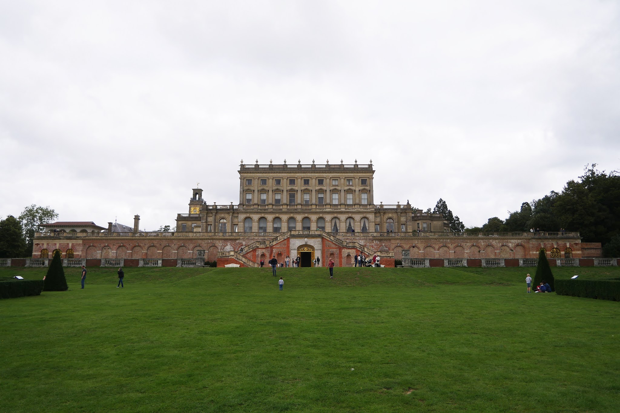
The present Grade I listed house was built in 1851 by the architect Charles Barry for the 2nd Duke of Sutherland.  Two previous houses on the same site burned down. The house sits 40 metres (130 ft) above the banks of the Thames and its grounds slope down to the river.

Cliveden became the home of the Astor family in the 1920s and in the 1960s was notorious for its contribution to the Profumo affair. After the Astor family stopped living there, it was leased to Stanford University, which used it as an overseas campus. Today the house is leased to a company that runs it as a five star hotel. 

We started with the lovely water garden with its Chinese Pagoda.

Of particular interest was this heron standing stock-still on a concrete block. 


We had some fun with whether it was live or statue. Even when it moved its head there was some willingness among our group to believe it was an automaton ... The matter was only resolved definitively when it flew off.

We ambled through woodland to come out at the rear of the house. The view from the terrace was wonderful, although you couldn't see the river.

We headed round to the front,  the main car park and entrance to the hotel.

To the right was the magnificent gilded Clock Tower. The  100 foot (30m)  tower was added in 1861 and was the work of the architect Henry Clutton. An open exterior staircase can be seen on the right. The tower still functions as a water tower and provides water for the house.

We paused for refreshments at the Orangery and admired this dovecote on the corner of the building.

Returning to the front of the house, we walked along the main drive to pass the lovely scalloped-shaped fountain. It is known as the shell fountain, or the Fountain of Love. It was commissioned by Lord Astor from the sculptor Thomas Waldo Story in Rome in 1897 and for this site.

It remained only to return to the car park.  I have focused on some of the buildings (others we missed), but a great deal of fun was also had by the kids involving games with sticks, a frisbee, and general chasing around. A wonderful day out. I wished I had been sooner!

Saturday 29 August 2020

Upavon


                                                        St Mary the Virgin, Upavon

We started our walk from Upavon at the parish church. The original wooden Saxon church was replaced by a late Norman church (circa 1175), but what you see now is largely the result of 15th and 19th Century restorations.

The village, which we didn't really explore fully, has some nice thatched cottages.

On the edge of the town was a rather unusual cottage, brick built and quite tall, but surmounted by a thatched roof.


We headed west to cross the River Avon ...

... and then climb quite steeply through woodland to suddenly emerge in open countryside.


We walked along the edge of a well-tended golf course: this was one side of the simple triangular route. Meeting a crossing track, we turned left for the second leg. This offered wonderful wide open vistas.

A bit further on we had a glimpse of the White Horse near Alton Barnes. It was first carved in the chalk in 1785 and re-cut a hundred and fifty two years later to mark the coronation of George VI.

Soon after this the track began to descend and no closer picture of the White Horse was possible. We turned left onto the third stage of the triangular walk, a grassy track. It was pleasant enough, but not as rewarding as the earlier sections. 

The final amusement was watching a mixed flock of geese successfully block the traffic while they searched for food.

Conditions: bright and sunny.

Distance: 4.25 miles.

From: Wiltshire: from Salisbury to the Kennet (Jarrold).

Map:  Explorer 130 (Salisbury & Stonehenge).

Rating: four stars.

Thursday 27 August 2020

Mildenhall


We parked in the centre of the village and headed east past the Village Hall and the Cricket Ground. Our first discovery was that not only is Mildenhall known as "Minal", this name is actually used on the Village Hall and the Cricket Ground.

We turned right and crossed the pretty River Kennet. We couldn't quite decide how much we liked the new house on the far bank. It was certainly striking.

We headed along the road for a short way then took a left into path leading across a large field. We knew that the walk was basically a rectangle and we could see on the right the high ground we would doubtless be returning on.

We passed the fortified Roman site of Cunetio - sadly no traces remain, although the Cunetio Hoard was found there. It was the largest collection of Roman coins (almost 55,000 of them) ever found in Britian.

Now were closer to the river and it was surprising to see that first the right bank and then both banks had been mowed. There were also a couple of benches. A sure sign of private ownership!

Reaching Stitchcombe, we turned right and climbed quite steeply to high ground and then turned right again to follow a parallel route to the one we had previously taken. We continued along this line until we were opposite Mildenhall. Here we turned right, descending open access land. It was raining now and the hillside was quite slippery. It looked like a lovely piece of chalk down and on a better day would probably have been busy with butterflies.

It was interesting to see how close we now were to Marlborough. The spires of the two main churches can be spotted at the edges of the photo, behind a densely packed housing development.


At the bottom of the descent a couple of lanes led us back to the bridge over the Kennet. We turned left and walked long the back of the Cricket Ground to reach the Church of St John the Baptist, photographed from under a tree.

It dates back to Saxon times and has a 12th century nave and Georgian box pews, pulpit and gallery. Just beyond the church we reached the main road and our car. 

Conditions: pleasant at first, but wet later.

Distance: 5.25 miles.

From: Walking in the North Wessex Downs.

Map:  Explorer 157 (Marlborough & Savernake Forest).

Rating: four stars.

Friday 21 August 2020

Great Bedwyn and Crofton


We parked at the canalside car park in Great Bedwyn and put our walking boots on as normal. Then there was a nightmare exchange: "Have you got the walk book and map?" "No, I thought you had them!" We knew from looking at the map where the first key point was: turning right shortly after the church and we were confident that we would always know more or less where the canal was ... so we decided to to do the walk anyway.

We walked through the village and turned left into Church St, passing the church and turning right at a footpath sign. So far so good!

We followed the path between fields to reach a couple of isolated houses. The nearer one was an interesting melange of traditional and modern.


We turned left into a small area of woodland and then took another left to pass the second, more conventional, house. The woodland quickly gave way to a pleasant track and after a while we encountered some people picking sloe for sloe gin. We weren't totally sure we were on the right track when we started to see a line of houses. I wondered what settlement it could be. When we reached the road it all became clear: we had emerged on the edge of Great Bedwyn, about 300 yards on from where we took the footpath sign!

Fortunately, the road was signed to Crofton, our next major destination. So we plodded along the merciful quiet road until we reached Crofton, the home of the celebrated Pumping Engines.

From Wikipedia: "when the canal was built, no reliable water sources were available to fill the summit by normal gravitational means. However a set of usable springs were found adjacent to the canal" and the pumps were used to supply water to the canal. The two engines date from 1812 and 1846. The 1812 engine, made by Boulton & Watt 1812,  "is the oldest working beam engine in the world in its original engine house and capable of doing the job for which it was installed".

We crossed the railway line, always an exciting moment, and then crossed a canal bridge which gave a good view of the Pumping Station in relation to the canal.

Now we were definitely in the right place and all we had to do was to walk the mile and half along the canal tow path. At first the canal seemed wider than usual.

But soon it resumed its more normal dimensions. The section from Crofton to Great Bedwyn is one of the most attractive we have walked along.

Conditions: rather grey.

Distance: 4.5 miles.

From: Walks in the Kennet Valley and Beyond (West Berkshire Ramblers).

Map:  Explorer 157 (Marlborough & Savernake Forest)

Rating: three stars.

Sunday 2 August 2020

Mapperton


Mapperton

"There can hardly be anywhere a more enchanting manorial group than Mapperton", wrote Pevsner, and it is difficult to disagree. We started our visit in front of the house, which is L-shaped, with a main building and a wing on the left hand side, clearly added later. 
 
Here is the front-on view of the 16th century core from the gates. The left (East) range dates from the 1660s.


On the right is the private chapel of All Saints. It is medieval, but with many of the windows dating from 1704.


Looking back from the entrance, there are a pair of 17th century stable ranges.
 
 
Sadly, you can't visit the interior at present, although Pevsner's write-up suggests that it would be well worthwhile. Instead you go through a gate on the left hand side which brings you to the side of the house which faces a large lawn.

 
And then you come to what we thought was the most surprising feature of Mapperton: at the back of the house there is a substantial valley, which gradually tapers away. The landscaping dates from 1927 and was modified in the 1950s and 60s.


At the end of the valley is this Orangery, which is unusual for being full of plants.

The formal gardens are divided into two parts, the upper part as above, and the lower part built around a water feature.

We followed the pleasant woodland trail which extends in a loop down through the trees. There was this rather nice view of the lower section of the garden as we returned.


Conditions: warm, but cloudy.

Rating: four stars. Delightful.

Saturday 1 August 2020

Corfe Mullen

Lady Wimborne Cottages
 
The last few days have been quite busy, so we decided on a short local walk for today's outing. We started at the Lambs Green Inn in Corfe Mullen, which looked to be a nice pub, and continued along the lane. We soon turned right and were delighted to find a pair of Lady Wimborne cottages.

Canford Manor (now a school) was bought by Sir Josiah Guest, a wealthy ironmaster, and his wife (Lady Charlotte) in 1846 and turned into a mansion by Sir Charles Barry Jr. Lady Charlottle evidently had a social conscience and promoted the building of good quality houses for her estate workers. The first cottages, with three bedrooms and a separate privy and pigsty, were built in nearby Merley in 1867. Building of the distinctive houses continued in various locations around Poole until 1904. Around 111 houses were built. The buff coloured bricks, the plaques which you can see above the first floor windows and the elaborate drip mouldings over the windows are distinctive features. A fuller picture can be found in this excellent post from the Poole Museum Society.

Soon afterwards we reached a brick bridge which once went over the Bournemouth to Bath railway line which was opened in 1872. You can still just make out railway bed, but it is very overgrown.

The next section leads through the wooded, and wonderfully named, Happy Bottom Nature Reserve. 
I am sure my 3 year-old grandson would be in fits to hear of such a place.

We emerged to cross a road (the B3074) and continue along a dead straight track, which was once a Roman road from Hamworthy to Badbury Rings and Hod Hill. You can see on the OS map that it is arrow-straight from Upton almost as far as the pub. Another lengthy straight section runs north from Badbury Rings.

A couple of left turns brought us  back to the B3074 and a good view of another railway bridge.
Here the railway bed is in good shape and may provide a nice walk.

We walked along Ashington Lane and just as we were about to turn left into a path leading to the small valley which is Happy Bottom, we spotted more Lady Wimborne houses. These are in very good shape and have variegated drip mouldings ...
... but the pair down the hill have not fared so well.
Sadly, Happy Bottom was rather underwhelming and we soon left it to follow a path alongside the railway cutting called Wayman's Way, given as a right of way by Charles Wayman. This led us to the railway bridge which marks the end of the disused railway. We turned right here to retrace our steps to the pub. 

We did however get a distant view of Wimborne Minster.

Conditions: grey but quite warm.

From: Pub walks in Dorset (Countryside Books). The directions were very good, but the sketch map was harder to follow and didn't seem to be entirely to scale.

Map: Explorer 118 (Shaftesbury & Cranborne Chase).

Distance: 3 miles.

Rating: three stars.