Thursday 31 March 2011

Venice: Santo Stefano - San Marco - Rialto

Piazza San Marco

About the walk

Another impromptu walk. Like yesterday, we were sitting in Campo Santo Stefano having coffee and deciding what to do with the day. We decided to go the Rialto area to do some shopping. But rather than go there directly we thought we would take a scenic route via the Piazza San Marco. Thus we began a sort of anti-clockwise tour of the sestiere (district) of San Marco.

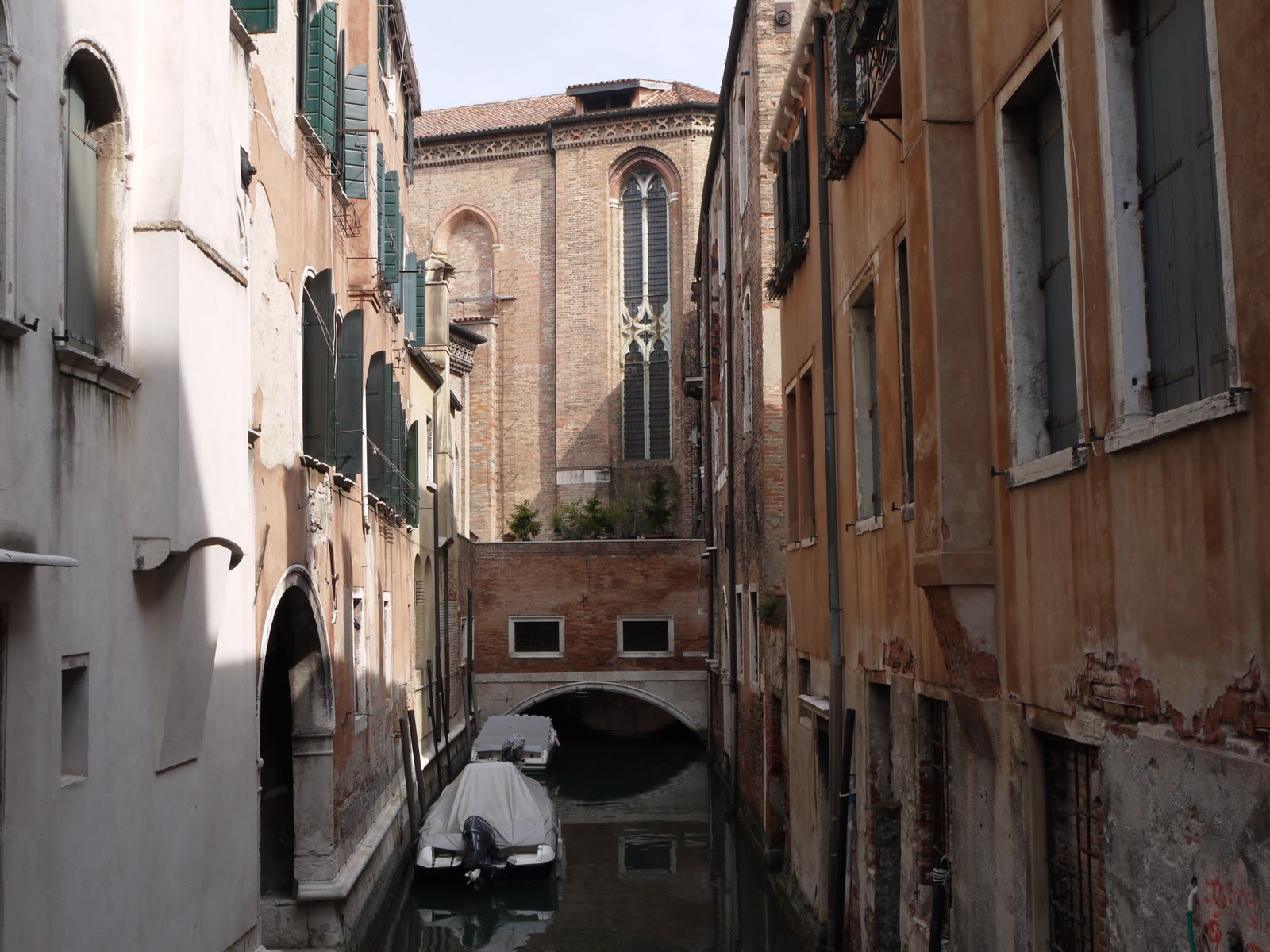
Crossing a small rio in the direction of San Marco we saw this wonderful view of the side of the church of Santo Stefano which demonstrates an extraordinary fact about the church - a small canal runs under it. Canals are everywhere in Venice, but this is a first.


We then made a short detour down to the edge of the Grand Canal to photograph one of the most striking palaces on it, the Palazzo Barbarigo. The owners were Murano glass blowers intent on bringing awareness of their product to a wider audience.


Back on the route towards San Marco, the Campo San Moritzio offers a view of the campanile of Santo Stefano which clearly reveals just how much it is leaning.


Once we reached Piazza San Marco (see the picture at the head of this post) we were struck by how much restoration is currently going on. The major works apparently are underpinning the campanile. This is probably a good idea since the existing campanile was built a hundred years ago as an exact replica of its predecessor which had collapsed.

Here is a nice detail of the facade of the cathedral.


We walked under the astronomical clock, which dates from 1497, ...


... and headed towards the Rialto. The main route is the Merceria. I spotted a very appealing jacket in the window as we passed by and so by the time we eventually reached Rialto, I no longer needed to doing any shopping. (This is of course a rather male approach to shopping; females know that shopping is not a zero-sum activity.)

We decided however to make a detour to see one of Venice less well-know sights, but one of our favourites, the exterior staircase of the Palazzo Contorini de Bovolo.


As we made our way finally towards the Rialto, we enjoyed this view from Calle del' Ovo of the narrow Rio del Salvador, full of gondolas, with the campanile of San Marco in the background.


Finally we emerged onto the side of the Grand Canal to enjoy a view of the wonderful Rialto bridge.


Max Mara beckoned and now it was time for some serious shopping.

Conditions: sunny, hot in the open, cool in the narrow streets

Distance: about 2.5 miles

Rating: four stars

Wednesday 30 March 2011

Venice: Campo Santo Stefano to Campo San Giacomo dell' Oro

Campo Santo Stefano

We were having coffee in a cafe in Campo Santo Stefano and wondering where to walk today. Looking at our walk book, an answer emerged: to start where we were, walk south to Dorsoduro and then swing north into the San Polo sestiere (district).

We started by revisiting the church of Santo Stefano, a fine 15th century gothic structure with a magnificent ship's keel roof. Photographs were not allowed unfortunately.

Then we crossed the Grand Canal at Accademia bridge and took a slightly different classic photograph (than the one we took yesterday on our Grand Canal walk) looking down the Grand Canal towards the Salute.


We then found our way towards the Fondamenta Nani, with the campanile of the church of San Trovaso looming at the end of the narrow street we were walking along.


Turning left into the Fondamanta, we soon came abreast of the Squero de San Trovaso, one of the few remaining workshops in Venice to make and repair gondolas.


At the end of the Fondamenta you reach the Zattere, the wide promenade beside the Guideca canal, where we walked yesterday. We made a short detour to the right to see the Molino Stucky on the island of Guideca opposite. One of the few industrial buildings in the the core of Venice, it is now a five star Hilton hotel.


From here we headed back to the rio de Trovaso, and walked up the other side, passing close by the church. We then headed north west to reach the small Campo de San Barnabo and cross the celebrated Ponte del Pugni (the bridge of the boxers).


In former times, there was intense rivalry between the Castellani, who lived in the southern and eastern sestieri of San Marco, Dorsoduro and Castello, and the Nicoletti, who lived in the the northern and western sestieri of Santa Croce, San Polo and Cannaregio. Ponte del Pugni was where this antagonism was played out in the form of mass fist fights.

Carrying on broadly the same direction, we next came to the triangular Campo Santa Margharita, one of Venice's largest. The rectangular building in the centre is the Scuola dei Varotari (leatherworkers) - one of the innumerable confraternity buildings which are scattered across Venice.


A little further on we reached one of Venice's greatest churches, Santa Maria Gloriosa dei Frari, the Frari for short. It was begun in 1340 and completed a century later. The massive campanile is 70m high.


We did go inside for once and admired the imposing space and, among a number of artistic delights, the magnificent Assumption by Titian and a superb tryptic by Giovanni Bellini.

After a restorative lunch in the Campo San Polo, we headed on to our final destination, Campo San Giacomo dell' Oro. This houses the very old, but rather unimpressive-looking church and was a veritable hubbub of activity, including a group of kids having a lively game of football. There was no evidence of a higher skill level than you would see in a comparable English location.


Conditions: sunny, hot in the open, cool in the narrow streets.

Distance: about 3 miles.

Rating: four stars.

Tuesday 29 March 2011

Venice: Grand Canal and Dorsoduro

Ponte degli Scalzi

The first day of  a week in Venice and what better way to get reacquainted with the city than a tour down the Grand Canal partly on foot and partly by vaporetto (water bus). The plan was to cover virtually the whole of the Grand Canal, from the Ferrovia (railway station) at the top end to where it meets the Guideca Canal and opens out into Bacino San Marco by Piazza San Marco. Vaporetto line 1 runs up and down the Canal, with stops more or less on alternate sides

We walked along the canal side from Ferrovia for a short distance to cross the Ponte degli Scalzi, one of only four bridges across the Grand Canal. The existing bridge dates from 1934 and was built to replace a 19th century iron built by the Austrians.

We walked through the usual maze of small streets to reach the next stop, Riva di Biasio, pausing to study the undistinguished, but unusually narrow Palazzo Flangini. It is said that exactly half of it was demolished out of spite in a row between two brothers who inherited it.

Now we hopped on another vaporetto to the next stop, San Marcuola for what our walk book promised would be an interesting view of the Palazzo Vendramin-Calergi, now the municipal casino. This was a deep disappointment. The view from the canal, once we were back on another vaporetto was much more pleasing.


We soon interrupted our route again to visit the museum of modern art in the Ca' Pesaro. There were some nice late 19th and early 20th century paintings, but it was also wonderful to able to see the spacious interior of this magnificent 17th century palace, one of the largest on the Grand Canal.

Resuming our vaporetto journey we passed the handsome Pescaria (fish market). It dates from only 1907, but looks older, being built in a convincing neo-Gothic style.


Soon afterward, we passed under the Rialto bridge, one of the great symbols of Venice, from the less touristy side.


The wooden Rialto bridge which can be seen in medieval paintings was destroyed by fire in 1514 and was built in 1588-91 to the ambitious designs of the appropriately named Andre del Ponte.

Beyond the bridge, the Grand Canal stretched out in an imposing fashion. I tried for a Canaletto style image.


We admired the fine palaces innumerable. The one on the right is the Ca' Foscari, with the Palazzi Giustinian and Bernardo Nani beside it.


By the time we got off at the third bridge, Accademia, we were starting to feel hungry and decided to head for the north side of the Dorsoduro where we remembered a nice restaurant overlooking the Guideca canal. First however, we climbed onto the bridge for the obligatory shot towards the mouth of the Grand Canal with the great church of the Salute on the right.


We headed confidently off and soon passed through the lovely campo Sant Agnese.


Slightly to our surprise, once we reached the canal side path we quickly located the restaurant, La Calcina, and had a leisurely lunch in the sunshine. We hadn't remembered that it was Ruskin's home in when he was writing his epic Stones of Venice. On the other bank, Palladio's imposing church La Redentore dominated the sky line.

We decided to do an impromptu walk around this section of the Dorsoduro and wandered inland to came to the beautiful 16th century facade of San Gregorio.


And then headed back to the Guideca canal for a fine view of San Georgio Maggiore, Palladio's other great Venetian church.


We now circled round underneath the Dogana, the customs house, and admired the view across to San Marco.


We took the vaporetto across and could now clearly see the top of the Dogana - . The building dates from 1677 and was apparently conceived as the prow of a ship - this is more apparent from the Bacino San Marco. It put us in mind of the Vienna Secession building.


Conditions: sunny, hot in the open, cool in the narrow streets.

Distance: about 3.5 miles of actual walking, and about 4 miles of vaporetto.

Rating: four stars.


Reflections

We hadn't made much use of the vaporetto network on our previous visits to Venice, but armed with a week's rover ticket it is an excellent way to get about and a much cheaper way of seeing the Grand Canal than a gondola trip, wonderful though that is. It will also allow us to take walks to distant parts of the city and not have to walk back. But most of all, it solves the perennial problem of crossing the Grand Canal. Otherwise you take have to take circuitous routes to use the two main bridges (Rialto and Accademia) or use the gondola ferries (traghetti) located at various points.

Sunday 27 March 2011

Randwick to Coaley Peak (Cotswold Way 9 )

Looking back towards Stroud

We return to the Cotswold Way project with Merv and Pud, picking up the route at Randwick and descending through grassy fields to cross the Frome Valley to the west of Stroud. Sadly, it is again very hazy and so it is pointless to try to take any landscape photographs.

We cross the path of the river Frome, here canalised as the Stroudwater Canal, and at this point have a choice: straight ahead lies the direct route via Middleyard to Pen Hill, to left lies the scenic route via the canal and Selsley. Naturally we take the scenic route.


Initially, the scenic route follows the canal bank towards Stroud. The canal was part of a network which supplied coal to the mills of Stroud and was abandoned in 1914-18. It has now been partially restored and further works could be seen as we walked along.

At the point at which we left the canal, Ebley Mill could be seen ahead. The chimney and tower are by GF Bodley. It is now the headquarters of Stroud District Council.


We left the canal at Oil Mill Bridge. The Oil Mill is on the river, which here flows beside the canal, was built in 1721 to process rape and linseed oil, but this use apparently lasted only a couple of years and it was later used for cloth, corn and animal feed. It  is now the headquarters of Snow Business, suppliers of fake snow for movies and the like.


We crossed the A419 and climbed the steep grassy slope to reach Selsley (the view back to Stroud is shown in the photo at the head of this post).

We passed the imposing gatehouse and then the roofs of Stanley Park. According to Pevsner, the core of the building is Elizabethan, but the majority of what you see today dates from 1850 and 1871. It was the home of the Marling family.


Sir Samuel Stephens Marling owned Ebley Mill and also commissioned Bodley to build the fine church of All Saints which lies next to the big house.


There is a story that Marling insisted that Bodley should copy a church at Marling in the Austrian Tyrol, but Pevsner thinks this is apocryphal and that Bodley was simply deploying the French gothic style he was a master of. It is a very handsome building with a recently slate roof.

Inside, there is wonderful stained glass by Morris, Marshall, Faulkner and Co. It was "The Firm's" first major commission and all Morris's gang are represented: Philip Webb, Burne-Jones, Rossetti, Ford Madox Brown and Morris himself. This is Burne-Jones's Adam and Eve window - Eve looks to be modeled on Janey Morris.


I have read a lot about Morris and have long known about All Saints - but I had it in my mind that the location was Selsey - in West Sussex. So what a delight this was - an unexpected reward for taking the scenic route!

We now walked diagonally across Selsley Common and enjoyed the sight of these terracettes, caused by soil creep as moisture, frost and ice allow gravity to pull the soil down a steep hillside. Sheep and other animals have used the naturally occurring terraces as paths.


We met the direct route at Pen Hill and followed the line of the escarpment around through Stanley Wood to eventually emerge, rather weary now, into the open at Coaley Peak, the site of Nympsfield Long Barrow. It is a burial site of the Neolithic people who farmed the land here 5000 years ago. This barrow dates from 2500 BC. Earlier in the walk we saw the Belas Knap long barrow when we were en route from Cleeve Hill to Seven Springs.


Map: Explorer 168 (Stroud, Tetbury and Malmesbury).

Conditions: mild, cloudy, hazy, but at last dry underfoot.

Distance: 8 miles.

Rating: four stars.

Flower of the day

The goal of Flower of the Day is to drive improvement in my flower identification. This lovely Cuckoo Flower was featured in April last year as we walked from Sandhurst to Farnborough beside the river Blackwater, so obviously it has not been completely successful! It is becoming clear that this a spring flower which thrives by water, as today's was spotted by the Frome.

Monday 21 March 2011

Exton and Old Winchester Hill

Old Winchester Hill

We met up with our friends Viv and Giles for another of our regular walks, this time in the lovely Meon Valley. We started from the Shoe Inn in Exton and walked up the road to cross the A32 and skirt the edges of Meonstoke.

We walked along a short stretch of former railway (the Meon line from Alton to Fareham), then along a lane which soon became a track leading us into open country. We climbed up to reach a small road with views to the south over a gentle valley, with rolling hills beyond.


We now continued on an anti-clockwise course and took a path descending down the side of a field, with a fine view of Old Winchester Hill opposite on the other side of the valley (see the photo at the head of this post).

We climbed up a lane and then a track from the bottom of the valley, passing a bijou shepherd's cottage and a farm. We were surprised by the emergence from the hedgerow of what I have since (I think) identified as a juvenile Red-Legged Partridge. The view looking back from the slope of Old Winchester Hill was also impressive.


As we climbed the Hill we were surprised to see a small vineyard to our right. I haven't been able to find out anything about it however. At the top the extent of the earthworks which make up the iron age hill fort became clear. The Hill is also a Nature reserve and later in the year we could have expected to see a good selection of butterflies and orchids.


We now followed a track descending gradually into the Meon valley. We ignored any temptation to take the Monarch's Way to the north. I hadn't previously heard of the Monarch's Way, but the Long Distance Walkers Association website reveals that it traces the somewhat tortuous route taken by Charles II after his defeat by Cromwell in 1651 and runs from Worcester to Brighton, via Shrewsbury and Dorchester. The whole route is 615 miles in length is described as the longest inland trail within England.

We crossed the Meon line again ...


.. and followed a flower-covered path beside a small tributary of the Meon.


The path was flooded at the end, but we successfully broached some barbed wire to reach the A32 again - only to be nearly blown back into the wire by a large lorry which passed uncomfortably close to the edge.  From here we walked along the lane into Exton and headed straight to the pub without exploring the village. Still, we had done so when we walked from Exton to Warnford a couple of years ago. That post has a nice photo of Exton's restored 13th century church.

From: Pocket Pub Walks in Hampshire by Nigel Vile (Countryside Books). The version in the book starts from the Bucks Head in Meonstoke. Unfortunately, it was closed today, hence the start instead from the Shoe Inn in nearby Exton.

Map: Explorer 119 (Meon Valley, Portsmouth, Gosport & Fareham).

Conditions: sunny, hazy, hot.

Distance: about 6.5 miles.

Rating: four stars.


Flowers of the day

Lots of Celandines and also these Purple and White violets. The former were growing in some profusion on the slope of Old Winchester Hill.


Sunday 20 March 2011

Llanthony


Llanthony Priory

We were in Usk on family business and our cousins Ruth and Jon took us to walk in Black Mountains. We drove along the Vale of Ewyas and parked in the car park by the fantastic ruined Priory at Llanthony.  We could immediately see the scale and grandeur of the building.


The story of its origins is rather wonderful. A nobleman is out hunting, sees a ruined chapel of St David and decides there and then to become a hermit. A couple of years later the former chaplain of Queen Matilda joins him, they gather disciples and begin to build a church. Later it becomes the core of a priory for the Augustinian canons. The church which remains today was started in about 1180 and was suppressed in 1538 under Henry VIII's dissolution of the monasteries. The architectural style is transitional between Norman and early Gothic. The picture shows the south transept and part of the nave.

To answer the next obvious question, it seems that Augustinian canons follow the rule of St Augustine of Hippo and engage both in monk-like contemplation and in ministry to those outside. A priory is a monastery headed by a prior: it may be subordinate to an abbey (headed by an abbot) or not meet the criteria to be designated as an abbey by the Pope.

But now back to the walk. We walked past the little church of St David. Pevsner (actually John Newman in the Gwent/Monmouthshire volume of the Buildings of Wales) explains that it was fitted up as a church after the dissolution, using part of the 12th century infirmary as the nave, and of course subject to later modifications and a 19th century restoration.


We now walked across fields following the Beacons Way and climbed up through woodland and another field to reach the steep slope of the flank of a long ridge. As we climbed there was a good view south east to the Sugar Loaf (Y Fal in Welsh), a landmark for miles around at 550m.


At the top the Beacons Way joins the Offa's Dyke Path. But before heading along it, we admired the view of England.


We turned right and walked along the ridge with the Sugar Loaf in the distance.


Before long we came on a group of seemingly wild ponies.


We were now on Hatterall Hill at 531m and the silver ribbon of the Severn could be seen in the distance.


At this point time was running out and the clouds were darkening, so we decided to retrace our steps. After a short way the whole of the curving ridge lay before us stretching away to the north west.


While on the ridge we heard and saw several Sky Larks, a considerable number of Meadow Pipits and a couple of very large black birds, which we identified with reasonable confidence as Ravens.

On the slope back down there was time for a few more efforts to capture the setting of Llanthony Priory and to see a brown hawk, smaller than a Buzzard - perhaps a Hen Harrier.


Map: Explorer OL 13 (Brecon Beacons).

Distance: about 6 miles.

Conditions: sunny and warm, but windy and quite fresh on the ridge.

Rating: four and half stars.


Flower of the day

It was lovely to see this Celandine in the woods.