Monday 31 December 2018

The Test Way

Combe Gibbet

The Test Way is a 44 mile path which runs from Combe Gibbet near Inkpen to Eling at the top end of Southampton Water. An informative leaflet can be downloaded from the Hampshire CC website here.

We did the walk with our friends Viv and Giles and broke the walk into six sections of about 7 miles each.

1 Combe Gibbet to Hurstbourne Tarrant

2 Hurstbourne Tarrant to Longparish

3 Longparish to Stockbridge

4 Stockbridge to Awbridge

5 Awbridge to Lee

6 Lee to Eling

The strangest thing about the walk is that it takes quite a while before you actually encounter the River Test- not until well into the Longparish to Stockbridge leg - i.e. almost half way. And even after we had our first encounters with the river, a typical fast-flowing trout stream, it remained elusive. This of course is because the banks and fishing rights are almost entirely privately owned and therefore out of bounds.

We enjoyed walking and chatting with our friends, but the walk itself was pleasant enough, but never especially exciting, after the dramatic start. It probably didn't help that we had a long break between stages four and five because Viv had hurt her foot

This was my favourite image of the Test:


The tidal mill at Eling however was particularly interesting. It has been operational since at least the 15th century and continues in use today. The only other operating tide mill is in Woodbridge in Suffolk. There is another former mill, now the yacht club HQ, at Emsworth near Portsmouth - the end of the Wayfarer's Walk.


Thursday 13 December 2018

Mexico: Tulum

El Castello

There are three Tulums: the town (pueblo), the beach hotels where are staying and the Mayan ruins. This post is of course about the latter. Tulum is interesting in that it is the only Mayan city by the coast and the only one with walls around it. It was also one of the last to be built, albeit in a style which is more rough and ready than in the classic period.

You enter the site through a narrow passage way and emerge next to the Casa del Cenote: a building built on top of a cenote (a sinkhole-cum-well).


Over to the left, the coastal side, is an attractive round building, the Temple to the Wind god.


Looking inland it suddenly becomes clear that Tulum is quite a large site.


Next up on the same side is the imposing Palace of the Great Lord.


And the seaward side comes a small building which has an unusual carving over the doorway: a statue of the Descending God. A careful look reveals that his feet are over his head.


We pass round the back of the Castello and come round to look at its imposing seaward side. The Spaniards named it as a castle, but it seems that it was primarily a watch tower. Did the Maya know the Spanish were on their way? There is a nice view out to sea for the modern tourist.


And here is a view looking back towards the Castello.


Heading inland we admired the Temple of of the Paintings. This may have been the last Mayan building to be built before the Spanish conquest. It has carvings as well as paintings


As we ended this lovely walk we had a couple of nice nature encounters: a fine iguana (actually they were all over the site) ...


... and a pair of brown Coatis (we saw black ones in Costa Rica a few years back).


Conditions: hot

Rating: four and half stars. I was surprised by how big the site was. The sense of surprise is increased by the very narrow entrance way.

Wednesday 12 December 2018

Mexico: Tulum Beach


I haven't often blogged about walking along the beach - the walk around Shell Bay and Studland Bay is the only example which comes to mind. However, the beach at Tulum is rather fine and we had a very satisfying walk along it soon after we arrived.

Our hotel is towards the south end of the long line of hotels which are set at the back of the beach, among the palm trees. We headed south, with the Caribbean on our left, in the direction of the Sian Ka'an nature reserve hoping to get away from the built-up area. This was the view back after a while.


We came upon this sculptural piece of driftwood. Just as I was reaching for my camera, a couple appeared and she began to disport herself in various poses across the branches while he took pictures. Mercifully, they had vacated the spot by the time we got back.


Further on, another fine tree trunk enlivened the shore line.


After about 45 minutes walking we felt we had left the developed area behind. The density of washed-up seaweed was noticeably greater. It was tempting to carry on, but the afternoon was getting on so we headed back.


Soon a flock of birds passed us on the seaward side. They were soon identified as Sanderlings. Not being birders, we found it astonishing that the same birds can be found on Studland beach.


Rather wonderful, the flock then landed and flowed back and forth across the beach.


As it got darker, we saw some Frigate Birds and another flight of large birds passed by overhead which we could not identify.


Later I popped out to catch the sunset. It's always better going down over the sea, but here we had to settle for a landward setting sun.


Conditions: hot with a cooling breeze.

Distance: Perhaps 4 miles.

Rating: four stars. Delightful and varied.

Mexico: Coba

The Great Pyramid

We are stopping at Coba en route for our final destination of this wonderful holiday - Tulum. It is a sprawling site where you car hire bicycles or ride on pedal cars to get about. Naturally we are walking.

Like Ek Balam it is located deep in the jungle and far from fully excavated.  It was at its peak in 800-100 AD is thought by archaeologists to have covered 70 sq miles and had a population of perhaps 40,000. We begin our walk noting several ruined structures in the trees. It is hard to imagine what they might be. Our guide thinks that Coba may turn out to eclipse Chichen-Itza in 20 or 30 years time.


After a while however we come to what is by now a readily identifiable structure: a ball court. One thisn which has now become apparent is that although all ball courts have a similar structure, the dimensions/proportions of the various components are not at all consistent. Was the game played in the same way? Or did each city have its own rules? Who can say?


One advantage of walking was that we were able to follow quieter trails (and not be at risk of being run over all the time). The picture below shows a road (or sacbe), now totally overgrown, but which reminds us that Mayan cities were linked by a network of roads.


As ever, there are a few reminders of the more barbaric side of Mayan civilisation.


We emerged from the paths through the jungle to pass the bike park and encounter this rather fine structure, presumably a temple.


Our guide immediately leads us off piste through the jungle on a narrow path to a rather overgrown lake. Is it a centote? I am not sure, but it has a wonderfully mysterious feel to it.


Returning to the main path, we head to the Great Pyramid. It is Nohoch Mul in Maya, which means Big Mound - Great Pyramid may be less accurate, but sounds more impressive. We climb carefully up the rather battered steps and reach the summit at 42m, the highest we have climbed. This is the view: basically 100% jungle in all directions.

We had a nice chat at the top with a Dutch couple who had come here by bus from Tulum. Astonishingly, to us anyway, they hadn't even heard of Chichen-Itza.

Getting down was a bit more challenging and a fixed rope had helpfully been provided running up the centre of the pyramid. We observed a few people climbing down backwards clinging to the rope.


The other advantage of walking was that it was possible to spot a certin number of butterlies, generally perched on a sunny leaf in the otherwise shady path edges.


Conditions: hot and pretty clear.

Rating: five stars. I have to say that climbing the pyramids, especially this one was one of the great highlights of our trip.

Tuesday 11 December 2018

Mexico: Ek Balam

The Acropolis

We are on an outing from Valladolid to see the ruins of Ek Balam, a Mayan city which reached its peak in the 8th century AD and was then abandoned.

We walk along a track from the main car park, passing a couple of half naked young men with their skins painted, presumably in the style of a Mayan warrior. On the way back we realised that their game was posing for photos with tourists.

The entrance to the archaeological site involves passing through three massively thick walls to a small gateway.


The gate is an attractive structure, with, unusually, entrances on four sides.


We emerge between buildings into a wide grassy space with buildings on three sides. To the left are twin temples (known officially as Structure 17 or The Twins).


We climb a similar structure (the Oval Palace) at right-angles to the twin temples and are rewarded by a fine view over the site as whole. The Acropolis can be seen above the trees.


A grassy knoll to the right has this small building on top.


We head through the trees and climb the Acropolis, an impressive 32m high (7m more than El Castillo at Chichen-Itza, but not as much as Coba [42m] or Calakmul [45m]).

About two thirds of the way up, hidden under palm frond covers is this fantastic structure, only recently uncovered. It is believed to be the tomb of an important king named Ukit Kan Le'k Tok. There is remarkable stone carving and the analogy of a mouth is carried to extreme lengths with the monstrous lower teeth projecting forwards.


There is even some rather Egyptian-looking wall painting on the side of the door.


At the top we look back towards the Twins and the Oval Palace and all we can see is a sea of forest. It is the same for as far as the eye can see in all directions.

It is a bit more challenging coming down than it was going up.


Returning to the entrance, we pass the inevitable ball court.


Conditions: hot and sunny.

Rating: Five stars. A quiet and very interesting site. The tomb of the king was a fantastic highlight.

Monday 10 December 2018

Mexico: Valladolid

The Temple of St Bernard and the Sisal Convent

We are now in Valladolid, the third largest city of Yucutan State (third by a long way with a population of 45,000 compared to Mérida's 1m).  The city was originally founded in 1543 on a site to the north of its current location, but had to be relocated because of mosquitoes. Francisco de Montejo conquered the Mayan city of Zaci, demolished it and built his new city on the site. Like Merida it has a central square and a grid pattern of streets. And also like Mérida it is named for a city in Spain, which was at that time the capital.

Armed with a very useful map and briefing from our hotel, we headed along Calle 40 towards the centre. This was the view ahead. We quickly realised one common stylistic feature: the hood mouldings above the doors and windows as well as the colourful facades that we saw in Mérida.


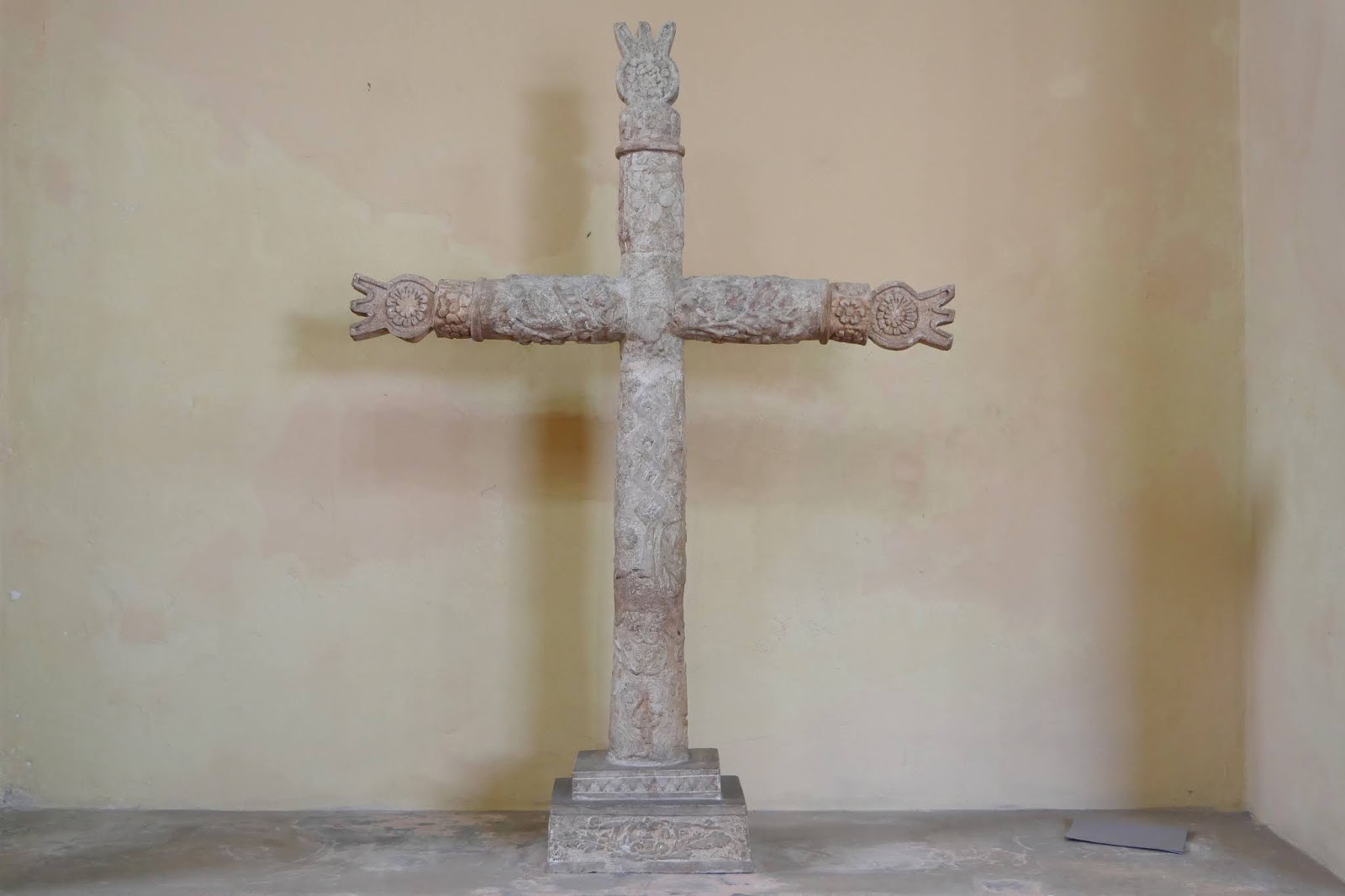
On reaching the main square we immediately made a detour to the right (Calle 41) to see the Museo de San Roque (a museum of regional history). It was once a hospital.


It was a bit old-fashioned inside and all in Spanish, but there was a marvelous crucifix.


We continued our detour to see the charming Municipal market where bought some avocados.


Returning to the main square we admired the facade of the Cathedral de San Gervasio. The original church was built using the stones of the main pyramid in 1545, but it was demolished and rebuilt in the early 1700s. It is the only church with a north-facing entrance in the Yucatán.


At this point we heard a commotion of car horns and sirens. It was yet another of the innumerable parties of pilgrims we have seen over the time we have been here. Small groups of mainly young men make a pilgrimage to the various shrines of Our Lady of Guadalupe. The cult began in Spain in the 14th century and was introduced into Mexico after 1531 when the Virgin appeared to a man named Juan Diego telling him to build a church in her honour. You can read the full story on Wikipedia. For present purposes, the key point is that the feast day is tomorrow, 12 December. Here is a typical group with the Town Hall (the Palao Municipal) behind.


The main interest of the Town Hall is a group of four lively paintings in a gallery on the top floor which depict the history of the city, starting with the pre-Conquest Mayan period, followed by the Spanish Conquest, the civil war of the 19th century and the revolution of 1910. Here is the Conquest painting.


Continuing to the north side of the square we admired another market (actually a modern construction) and a Spanish colonial style house which now contains a reasonable restaurant.


On the same side of the square is another nice pair of houses, the one on the left seems to be a Spanish colonial dwelling which has been unaltered, at least externally.


We headed along Calle 42 and returned along Calle 40, passing several more attractive buildings. Like the hood moulding, I think the pilasters are modern.


We now left the town centre and walked along the picturesque - and very well restored - Clazade de los Frailes ...


... to reach, at the end, the (former) Convent of Sisal and the adjoining church of San Bernadino di Sienna. They were built between 1552 and 1560. The convent was rather battered looking, the central cloister looked in bad shape - as well as being architecturally very dour.


We emerged outside to see this interesting structure in the garden. It is a water wheel built in 1613 above a cenote to provide water for the convent.


The church, was light and spacious with a long nave, with some nice vaulting at the end.


Outside, one the most striking, and uncomfortable, features, was the remains of the external chapel where Mayan converts were able to hear Mass - they were not allowed inside the church.


Conditions: hot.

Distance: maybe 3 miles.

Rating: four and a half stars. Les dramatic than Mérida, quieter, but calmer (apart when the pilgrims were passing by) and somehow more characterful.

We unfortunately missed Valladolid's most famous site: the Casa de los Venados, a privately owned art gallery, as it was shut at just the wrong times.