Showing posts with label statue. Show all posts

Friday, 20 May 2022

Brighton

We are here in Brighton to go to a gig at the Brighton Centre, conveniently located facing the sea. We are looking forward to enjoying Michael Kiwanuka and his band. The gig was first on our radar two years ago, but COVID and lock down created a long delay. Before the main business however we thought we would have a brisk tour around the city to remember sights we saw in our previous visit in 2010 and to enjoy some new ones.

We started at the Town Hall (above). The current building was commissioned to replace a previous town hall built on the western side of Market Street in 1727. The new building, which was designed by Thomas Cooper in the Greek Revival style and built at a cost of £60,000, was officially opened in 1832. Later the local police force, formed in 1838, established a police station in the building and police cells in the basement. The police cells were removed in 1965, but a police museum took their place.

We found our way into Ship Street and the imposing Seven Stars.

We wondered through the Lanes and emerged into North Street where we admired this redbrick building on the left.


Continuing in the same direction we found ourselves in the gardens of the wonderful Royal Pavilion.


This statue of George IV stands near the North Gate of the Royal Pavilion. It was put up in 1828 and paid for by public subscription. During his time as Prince Regent (1811-1820) he was responsible for the huge growth of Brighton and the building of the Royal Pavilion

As time was short we retraced our steps up North Street to reach the Clock Tower, one of the very many erected all over the country in honour of Queen Victoria's Jubilee. Our most recent sighting was in Ripon.

Now we hurried back to our hotel, passing several interesting buildings (OK, bars) ...


Then to the Brighton Centre where Michael Kiwanuka and his band put on a great, and long overdue, show. Below is is my best effort at an iPhone photo.


Tuesday, 26 April 2022

Lindisfarne

                                                                    Lindisfarne Priory

For our final outing in the North East we decided to see Lindisfarne or Holy Island. I knew from a friend that the island is connected to the mainland by a causeway which floods twice a day. Visitors are exhorted to check the tide times.  I didn't have any sense of what the causeway looked liked or how long it was. 

I now know that the causeway is a tarmaced road wide enough for two vehicles going in opposite directions. It is 3 miles long and the vast majority of visitors arrive by car. At high tide the road lies under 1.5 - 4 metres of water.

We parked in the large car park and walked towards Lindisfarne Priory. Holy Island has a recorded history which goes back the 6th century AD; it was an important centre of Celtic Christianity, especially St Cuthbert.   After the Viking invasions and the Norman Conquest a Priory was was re-established. A small castle was built on the island in 1550.

Below are two views of the Priory ruins. The monastery continued until its suppression in 1536 under Henry VIII's Dissolution of the Monasterie after which the buildings surrounding the church were used as a naval storehouse, and presumably began a long period of decline

 We concluded our visit of the Priory by admiring this modern statue of St Cuthbert by Fenwick Lawson. 

We could see Lindisfarne's other major sight as we were exploring the Monastery - the Castle, perched upon a rocky hill on the highest point of the island. It was constructed in 1550 and stones from the priory were used as building material.

We followed a road and then a grassy path towards the Castle, now looked after by the National Trust. When you get there it is a steep climb to the top.

In 1901, the Castle became the property of Edward Hudson, a publishing magnate and the owner of Country Life magazine.  It is said that Hudson and the architect Sir Edwin Lutyens came across the building while touring Northumberland and climbed over the wall to explore inside. 

Lutyens created a remarkably cosy and characterful building, and as you tour round it now you are taken by the small homely rooms, many of which have the feeling of having just been vacated. No doubt this was the work of the National Trust.

From the rear windows you can see the small walled garden which had originally been the garrison's vegetable plot. It was redesigned by Lutyens' long-time friend and collaborator, Gertrude Jekyll, between 1906 and 1912. It is some distance away from the castle itself. Between 2002 and 2006 it was restored to Jekyll's original planting plan by the National Trust.

On the opposite of the building there is a terrace which offers fine views back towards the main body of the island.


This view is particularly interesting, with the two columns at the back of the sands which remain important for navigational purposes. The thick black line in the foreground is ..... yes, hundreds of seals on a spit of land!


A wonderful experience!


Wednesday, 23 October 2019

Wantage

King Alfred's School

Another walk with my good friend Merv. In fact it is two walks: a circular walk from Wantage passing through Letcombe Regis, East Challoe and Cove, and a walk around the town itself.

We parked at the Beacon art centre and walked a short way along the road to pass the original King Alfred's School, which dates from 1849–50. From here a path led us towards open country which we crossed to reach the pretty village of Letcombe Regis. We we were very struck by this lovely half timbered house of 1698.


And also by the handsome Old Rectory opposite. I couldn't quite get a photo however. Nearby was the church of St Andrew. The tower is 12th century and other parts were restored or rebuilt in the 15th and 19th centuries.


We followed a narrow track with a lovely view across fields to typical downland countryside.


We turned right onto another track, along a short section of road and then along Cornhilly Lane to reach and then follow the former Wilts and Berks Canal. It was completed in 1810 (so late in the canal era) with the purpose of allowing coal to be shipped from the Somerset coal fields to the towns of Wiltshire and Berkshire. It went into decline only 30 years later with the advent of competition from new railways.

The first section of the canal was dry and required some imagination to recognise it as a canal.  At a crossing road we found this fine old building, we think once a forge but now converted into housing accommodation.


Continuing along the same line, the next section of canal had water in it, although covered by green algae. A new housing estate was just beyond the hedge on the left.


At the end of this section the canal side path was briefly diverted on account of a new housing estate. This did mean we saw a flock of Goldfinches - a lovely sight.

The estate was one of several built on the former airfield at Grove. An emblem of the airfield was this de Haviland Venom, a fighter-bomber introduced in 1951. I have no great interest in aircraft, but I was surprised by how modern it looked. It was only in service until 1962.


We now followed a network of paths through the outer areas of Wantage to reach the area known as the Wharf (the Wilts and Berks Canal once terminated nearby). This was once an industrial area and it was interesting to see that two mill buildings still remain.


We walked up Mill Street passing a set of Almshouses dating from 1868.


At the top of the road we passed the former Town Hall, currently being restored, and entered the oblong Market Place to start our town walk - which we decided to do in reverse order. The detailed route can be found here. The main item of note in the Market Place is the statue of Alfred the Great,  although Merv greatly enjoyed the massive second hand bookshop in a sort of arcade at the far end.


You might wonder there is a statue of Alfred here, and the answer is that he was born in Wantage. The statue was the work of Count Gleichen, Prince of Hohenlohne-Langenburg and was unveiled in 1877. The battleaxe in one hand and the manuscript in the other attest to Alfred's prowess as a warrior (victory over the Danes at Ashdown in 871AD) and to his education and statesmanship.

We headed down Grove Street passing the interesting Georgian Clock House


At the top we continued along the road and then turned right and right again to pass through a housing estate which was suddenly revealed to have the 18th century former stables of Stirlings House tucked away in it.


Now down to Post Office Lane to find the attractive Eagles' Close Almshouses of 1867.


Nearby in Newbury Road were the Stiles Almshouses of 1680. Their founder was Robert Stiles, a merchant ... of Amsterdam.


We then went along Church Street to see the 13th century church of St Peter and St Paul, which was sadly closed.


It was a short walk from there to the Beacon.

Conditions: quite mild, but mainly cloudy.

Circular walk distance: about 6 miles.

The walk route can be found here.

Map: Explorer 170 (Abingdon, Wantage and Vale of White Horse)

Rating: four stars.

Sunday, 22 September 2019

Padua: Cittadella

Our first view of Cittadella

We are on our way to Verona airport for the flight home, but we have spotted the opportunity to stop off on the way at the wonderful walled town of Cittadella, about 30 km north of Padua and midway between Castelfranco del Veneto and Vicenza.

We drive north and soon reach the centre of Cittadella, appropriately at the Porta Padova (Padua Gate). We were enormously impressed by the wonderful walls of Montagnana, but in many ways the walls of Cittadella are more impressive - they are certainly higher.


Cittadella was founded in 1220 as a fortified castle, designed to act as outpost of Padua in the Veneto, with the intention of protecting its borders from assault by Treviso and Vicenza. Nowadays. Cittadella is a town of 20,000 inhabitants - most outside the walls.

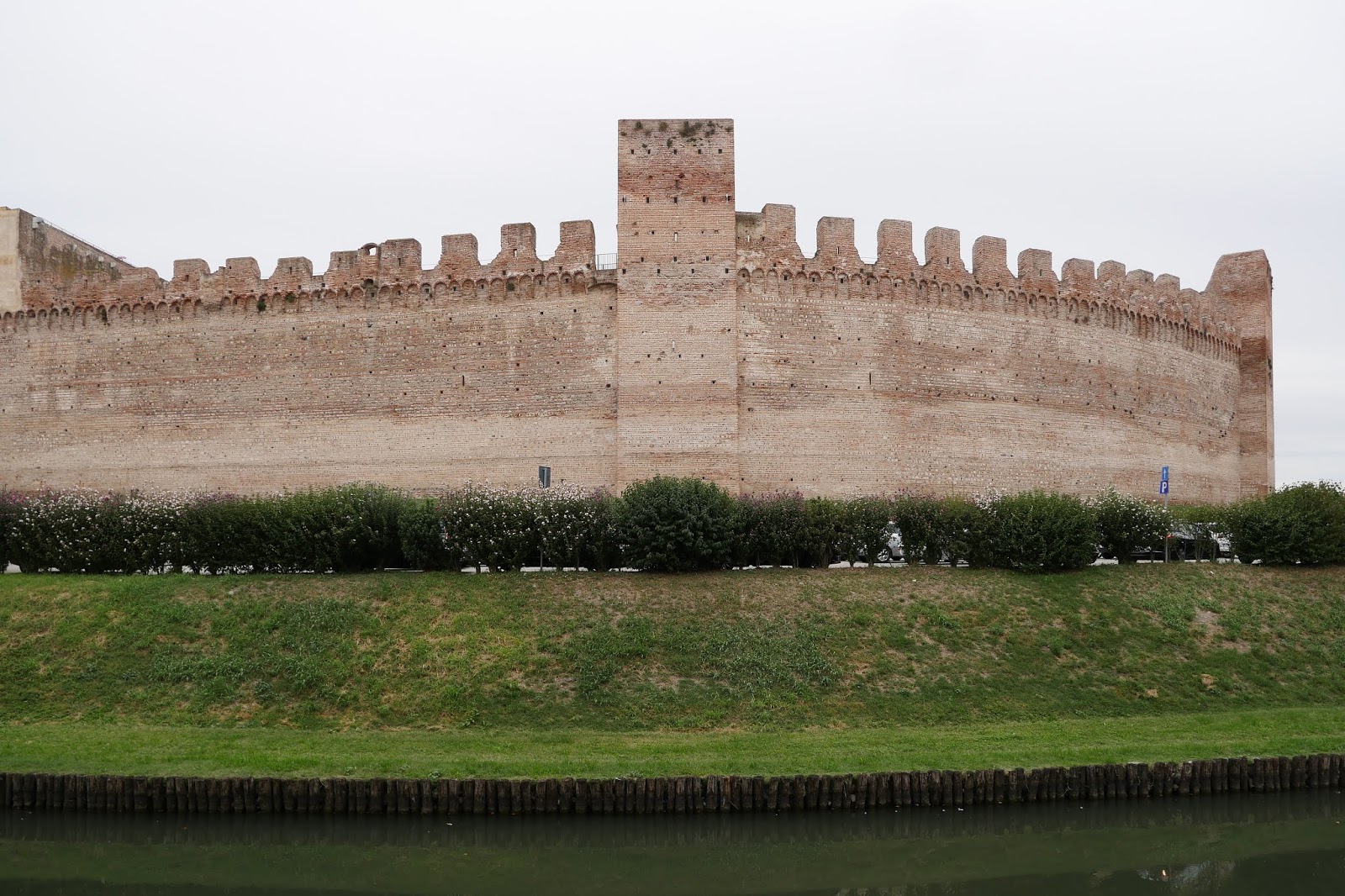
We decided to start by walking round the outside of the walls, to get a proper sense of them, They are basically oval, 1461m in circumference with four gates more or less on the cardinal points. This first section, anti-clockwise from the Porta Padova features a rather incongruous modern section.


We soon arrive at the Porta Treviso, with a substantial barbican.


The next section of walls is equally imposing and my photo features the moat which is fed by spring water and encircles the walls. It was once twice as deep and twice as wide as it is now and as well as being part of the defences it was a useful source of fish.


At the third gate, Porta Bassano we spotted some people on the top of the walls and quickly discovered that this is the main point of entry


We climbed up to the Tourist Office and bought our tickets for the Parapet Walkway, which was only opened in 2013 after 20 years of extensive renovation work. It is just wonderful! This is our first view of the area inside the walls. The main feature is the Duomo, built between 1774 and 1826. You can also see one of the two main roads which connect opposite pairs of gates.


Looking out from the parapets we had a good view of this beautifully frescoed house, which we had noticed as we were on Porta Bassano.


The main focus however is the imposing line of walls seen from the inside.


It was also impressive to see how the walkway passes through a whole series of towers.


This was the final quadrant, between the Vicenza and Padova gates. We were interested to notice the hills in the background.


We carried on around the full circuit (you can bail out at Porta Padova) and returned to ground level after a truly wonderful walk around the walls. We walked towards Porta Padova and at the central crossroads admired the inside view of Porta Treviso. There wasn't much to be said about the Duomo.


We headed onwards towards the Porta Padova, along a very quiet street ...


... enlivened at the end by this jolly statue.


Conditions: a bit grey.

Rating: 5 stars.

Note: According to the very helpful leaflet about the walls, other nearby walled towns include Bassano del Grappa, Marostica, Asolo and Castelfranco Veneto. We have been to Castelfranco, and indeed stayed there, but the others might form the basis of another trip!