Showing posts with label Somerset. Show all posts

Thursday, 13 April 2023

Almshouses of Taunton and South Somerset

The Taunton Heritage Trust  is rather like the The Exeter Homes Trust in that it covers several discrete almshouse buildings. The first and most impressive is Gray's Almshouses. They were founded in 1635 by the wealthy cloth-merchant Robert Gray, whose monument survives in the Church of St Mary Magdalene. The building is one of the oldest surviving in Taunton and is one of the earliest brick buildings in the county (from Wikipedia). 

17th century Gray's Almshouses in East Street, Taunton, founded by Robert  Gray. Still in use as sheltered accommodation Stock Photo - Alamy


Then we have the impressive Huish Homes. They are located in a  Grade II listed building, built in 1868, that provides four flats, a laundry room and a communal garden. The offices of the Trust are also there. 
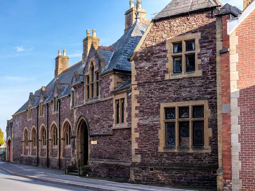
Huish


The buildings of Leycroft Close in Hamilton Road were built in 1931 and consist of 328 flats.
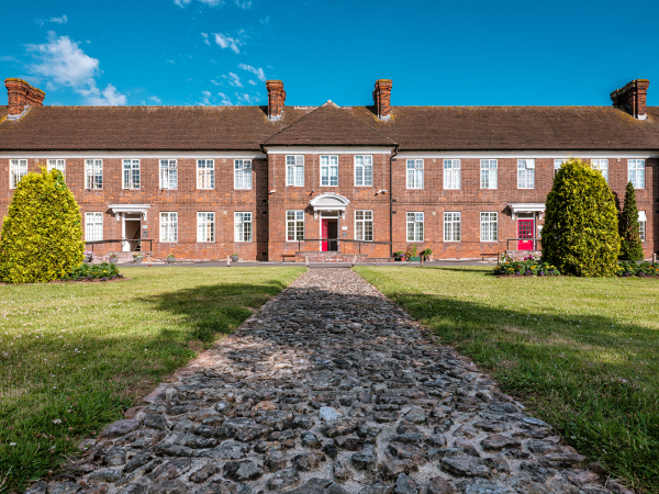
Leycroft Close

The St James's flats, dating from 1845, consist of eight flats with a shared garden.
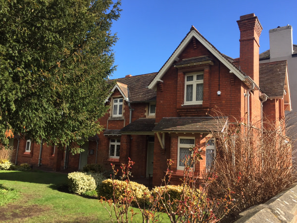
St James Close

Finally, the Bernard Taylor homes date from1984. The accommodation is intended for single occupancy, but there is a large communal area. 

The remaining Almshouses are the St Margaret's Almshouses. They began as a leper hospital - or Leprosaria - in the 12th century where diseased locals were isolated. The building is said to have featured secret underground tunnels to transport the dead to a nearby cemetery.  The almshouses are now privately owned.


St Margaret's Almshouses - Architecton 

St Margaret's Almshouses - Wikipedia

 Finally, I discovered a relocated almshouse preserved by Taunton Castle in the Museum of Somerset .

File:Museum of Somerset almshouse 03.jpg 

 To the south of Taunton there are Staple Fitzpaine with Portman's Almshouses.


These almshouses were founded by Sir William Portman and were restored in 1970.

To the east is the village of East Coker, famous for T S Eliot's celebrated poem. They were originally built in 1640 for 11 women and a man, and are still in use.  A plaque in front of a large tree marks the site of a "plague pit", where 70 villagers were buried in 1645.
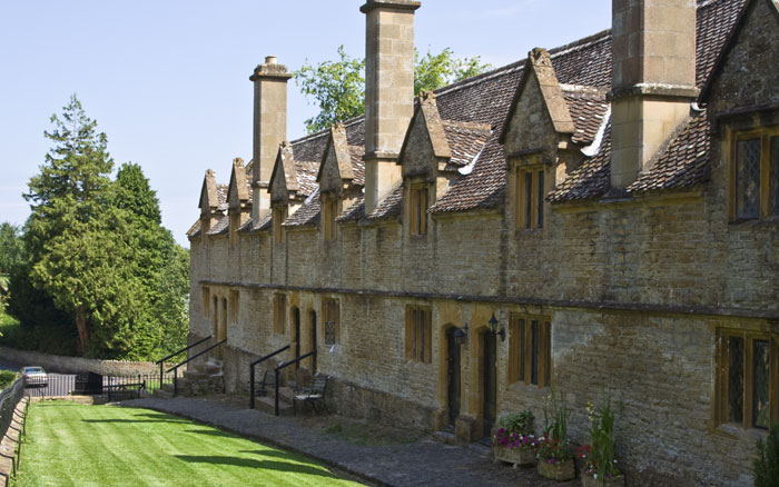
Alms Houses East Coker

Nearby is the village of Bishops Lydeard. The almshouses in the high street were originally built in 1616 by Sir Richard Grobham.  They were restored in 1854 and again in the mid 20th century.


Finally, there are Harvey's Almshouses. These almshouses were founded by an Exeter merchant called Richard Harvey in 1663.  He was born in Chard.  The original almshouses were demolished in the 19th century and replaced by the present building in 1841-42.


Thursday, 19 August 2021

Dunster Castle and town

The Gatehouse

On our way home from Lynton we decided to stop off at Dunster Castle, near Minehead. We had passed by the entrance several times in the past as we returned home from visits to North Devon, but there never seemed to be the right moment to stop.

The first castle on the site was built - of wood - just after the Norman Conquest by the De Mohun family. According to the Dunster website,  the De Mohuns sold the castle to the Luttrell family in 1376 and they were responsible for most of what we see at Dunster today. They built the gatehouse in 1420, created a Jacobean mansion in 1617, defended and saved the castle during the English Civil War and updated the castle in the Victorian era. The Luttrells lived there for 600 years until 1976 when the property was gifted to the National Trust.

Nowadays visitors go through the massive Gatehouse and then reach the 13th century lower level gateway with its massive iron-bound oak doors.


You emerge at the top into a large grassy area with the facade of the house before you. George Luttrell commissioned Anthony Salvin to remodel Dunster Castle in 1868-72. Luttrell employed the prolific architect Anthony Salvin, to redesign the castle and create a comfortable Victorian family home. Salvin had worked on many other castles and country houses including Alnwick, Caernarfon and Windsor Castle. At Dunster he altered the building’s exterior, demolishing the chapel on the south front, building two new towers and adding battlements emphasising its medieval origins.

We went inside to have a look. The rooms were very Victorian and perhaps you could say were quite cosy. The most striking room by far housed a set of 17th century leather wall hangings of Antony and Cleopatra. They are believed to be the largest and most complete of their type in the world. We were certainly impressed.


Emerging into the area in front of the castle we were very taken by this delightful structure, Tenants Hall. It was built on the upper storeys of the Gatehouse in 1764.

We decided - perhaps wrongly - to give the celebrated 18th century watermill a miss and instead have a brief look at the village of Dunster. We started by walking down to the very attractive West St, with its pastel-painted houses.

From there we walked back to the imposing Priory church which mainly dates from the 15th century.


A little further on, on the left, was the Dunster Village (or Secret) Garden, a delightful walled area managed by local residents.  Above the garden looms the Conygar Tower. It was commissioned by Henry Luttrell and designed by Richard Phelps. It was built in 1775 and was designed to be about 18m high so that it can be seen from Dunster Castle on the hill opposite. It was just a folly: there is no evidence that it ever had floors or a roof.

A little further on we came to this unusual and interesting building. It looks to be half-timbered with a slate-hung facade. There seems to be no evidence that it was ever used by nuns.

Turning into the High Street we headed to the top to see the splendid Yarn Market which was built for the wool trade in the 12th century,


Conditions: greyish and a bit wet.

Rating: four stars. A very interesting and enjoyable stop off. We doubtless have spent more time exploring the the castle, the village and its environs.

Thursday, 29 July 2021

Frome and Nunney Castle

                                                                    The Round Tower

Merv and I started our exploration of Frome at the Black Swan Arts Centre where we acquired a map. The Round Tower was built as a wool-drying stove in the 18th century and is a reminder of Frome's cloth industry. It is now the start of the town trail. Opposite, where the cattle market was, is the Market Hall, now a pub.

We crossed the bridge over the River Froom (1667) to reach the handsome Blue House. It was built as an almshouse around 1465 and rebuilt to include a school in 1724. The pupils wore blue uniforms which gave the building its name. It now houses flats for retired people. It was a shame that building works are underway.


We walked up the narrow Market Place and turned left into medieval Cheap St where an ancient leat (an open water course) channels water.

We then approached St John the Baptist's Church by following a path parallel to its wonderful Via Crucis (the Way of the Cross).


My photo of the church was taken from the rear, but one taken from the road (Bath St) would have been preferable. The first (saxon) church founded by St Aldhelm in 685AD and replaced by a Norman structure of the late C12 which was gradually extension until reaching the present footprint around 1420. It was largely rebuilt in the 19th century.

We walked down to Bath Street to see the very grand Rook Lane Congregational Chapel of 1707. It was so grand that many Chapel members found it offensive.

We returned past the church and turned right into Gentle Street, where two fine houses could be found on the right hand side: Argyll House of 1766 and 19th century Argyll Lodge.

We continued along the lane passing the massive former Lamb Brewery.


We turned right at the top passing Wesley Villas on the left, a complex of 19th century buildings, to reach the modest Town Hall.

Now left into Wine Street which led us to a delightful little street, Sheppards Barton, which was developed by the Sheppards to provide workshops and houses for cloth weavers. At the end of the street steps lead down into Catherine Hill.

This is the view downhill (back towards the Market Place).

We turned left and passed this curious lovers' post box and the Valentine Lamp, installed in 1993, inevitably on Valentines Day.

At the top end of Catherine St we turned right along Vallis Way which leads into the Trinity area. Our guide book explains that this area was one of the earliest developments of industrial housing in Europe. At the end of Trinity St we admired Trinity Church (1838). Only once I got home did I spot that the church contains stained glass windows designed by Burne-Jones and made by Morris and Co.

We turned right down Trinity St to pass the monumental Butler & Tanners Steam Printing Works.

We continued down hill via Trinity St, Castle St, Milk St and Cork St to return to the start of the walk.

To add extra spice to our walk we headed off to nearby Nunney, where a picturesque medieval castle, Nunney Castle, waited for us. It dates from the 1370 and its builder was Sir John de la Mare, a local knight who was beginning to enjoy royal favour. Much modernised in the late 16th century, the castle was besieged and damaged by the Parliamentarians in 1645, during the English Civil War.

This is the first view you get of the castle: you can deduce that it is rectangular with huge circular towers in each corner.

Once you get inside the enclosure it becomes clear that the Castle is surrounded by a moat. It  is pretty battered, but has a very impressive presence.

Conditions: bright and sunny.

Rating: four stars.

Friday, 4 August 2017

Porlock Weir to Minehead (South West Coast Path 103)

The end of the South West Coast Path

This is the final leg of the SW Coast Path! We set off from Porlock Weir in light drizzle, looking across the rocky beach towards Hurlstone Point. A small tower can just be made out part-way up.


We followed the road through the village and turned left to walk along the back of the beach for a while, passing the wooden stakes indicating the oyster beds.


Soon we had to turn inland because of a "breach". We followed a well-trodden path which eventually turned back towards the sea, passing a dramatic stand of dead trees.


We passed through the pretty village of Bossington, where we especially admired the brick columns of the cattle byre attached to one house.


We then began a long climb, passing inland of Hurlstone Point and thereby missing the small tower which we had seen from afar. I learn from Google that it is a coastguard lookout tower which was built in 1902, and remained in use until 1983.

We were now climbing Hurlstone Combe where we soon reached the heather line and plodded on up the long slope.


 At the very top there was a great view back towards Porlock Weir ...


... and also a fine one inland towards Porlock.


Soon afterwards we ignored the sign for the "Rugged Coast Path" to continue along the regular Coast Path across moorland, passing Selworthy Beacon at 308 metres, only 10 metres lower than the Great Hangman which we climbed recently on the Combe Martin to Hunters Inn section. It turned out that we had somehow drifted off the official path at this point and it took us a while to edge our way back onto the correct route.

By the time we achieved this we were opposite Grexy Combe with North Cliff largely out of shot to its right. The trees were quite picturesque.


As we approached Minehead we were rejoined by the Rugged Coast Path. We were still over 200m above sea level and soon the path made a zig-zag turn towards the sea. The variations in colour were fascinating.


We descended steadily and entered some woodland, emerging eventually onto a minor road which took us into Minehead. It was interesting to see the stony beach in the foreground and the sandy one in the distance. We concluded that at some point in time the rocks had been cleared from the sandy area.


We headed inland in search of the Duke of Wellington in Wellington Square. We passed these rather lovely Coastguard Cottages built in a lovely red sandstone, which we quickly discovered was characteristic of the town.


Just before Wellington Square is Mansion House Lane where the Quirke Almshouses are to be seen. Founded 1630 by Edward Quirke, merchant and mariner, and restored 1986. Note the bellcote at the far end: it reputedly houses a bell from one of Robert Quirke's ships.


Wellington Square is home to St Andrew's church, in front of which is this fine statue of Queen Anne, by Bird who made the similar one which stands outside St Paul's in London.


We now adjourned to the rooftop beer garden of the Duke of Wellington to celebrate our completion of the South West Coast Path with a nice bottle of Wetherspoon's reasonably priced Moet et Chandon.

Conditions: Quite warm, but mainly cloudy.
 
Distance: 9.5 miles.
 
Map: Explorer OL 9 (Exmoor).
 
Grading:  Moderate.
 
Rating: four stars.