Showing posts with label North Devon. Show all posts

Wednesday, 18 August 2021

Lynmouth and Watersmeet

The East Lyn River

Today Jim and Em are taking us on a walk to see Watersmeet. We walked down from Lynton to reach Lynmouth and our first sight on this trip of the East Lyn River. This was famously the location of the devastating 1952 flood which resulted in 32 lives lost. A substantial programme of remedial works  successfully prevented a repeat.

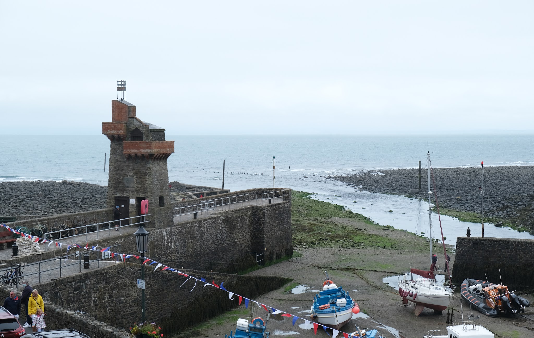
We passed the harbour with its delightful Rhenish tower (c 1860 by one General Rawdon), rebuilt after the 1952 flood. It is a pity the tide was out.
We continued along the right bank of the river and then cross to the left where we had a nice view of the church of St John the Baptist (1869, with later additions in 1908 and 1921).

 
Soon we saw this delightful creature climbing up the right bank ...
 

... while on the left we spotted a new horror: artificial hedge! It looked truly awful. I couldn't bring myself to take a picture.

Soon we left Lynton behind and crossed the rather lovely bridge to enter the woodland.
 
 
We followed a climbing path through the woods with the pretty river on our left. Quite soon we started to spot Grey Wagtails with their characteristic nodding (or perhaps I should say wagging) behaviour.
 

 As we got nearer to Watersmeet the river became more rock-strewn.
 

Watersmeet marks the joining of the East Lyn and Hoar Oak rivers. The house usually provides a cafe and loo, but sadly not today.
 
 
We headed back along the opposite - and rather quieter - bank, admiring another shapely bridge.
 
 
Further along, these trees stood out along the hillside ...
 

... and a little further on this fallen tree had been embellished by banging coins into the wood. I would love to know whose idea it was and what was its purpose.


We carried on back to the start. My arthritic knee was beginning to play up so we thought about taking the the funicular up to Lynton. When we got to the entry point we quickly realised that this wasn't a viable option as there was a long queue ahead of us. I gritted my teeth and plodded slowly up the hill.

Conditions: grey, but mild.

Map: OL9 (Exmoor).

Distance: about six miles in all, including the descent from and climb to our base in Lynton.

Rating: four stars. Delightful.

Tuesday, 17 August 2021

Lynton


After our excellent walk around the Valley of Rocks, I decided to make a short blog of what we saw as we approached and then walked through Lynton. The first interesting feature was the Funicular Railyway which connects Lynton (high above the sea) with Lynmouth (at sea level). The funicular is interesting for being the only water-powered one in the world. The left hand picture shows one carriage coming down from Lynton, while the right hand picture shows the specific point where the two carriages cross.

We continued along the path and enjoyed this lovely view down to Lynmouth. It does illustrate however Lynmouth's main weakness: the lack of a sandy beach.

We emerged opposite the Church of St Mary. The nave south wall dates from 1741, but everything else is 19th century.

A right turn led us past the imposing main entrance to the Valley of Rocks Hotel. The rest was less interesting.

We walked along Lee Road to soon reach the rather splendid Town Hall of 1898-1900. Pevsner is not so positive: "Small, but certainly an attempt at municipal architecture in a holiday spirit ... Utterly un-Devonian." I think that is rather harsh.

Further along was the interesting United Reformed Church in a rather similar style.

At the end of Lee Road was the Holy Saviour: a Roman Catholic church attached to a convent of the order of Poor Clares. It a rather austere building dating initially from 1910, but not completed until 1931. Pevsner describes it as "decently and honestly utilitarian", and I can't disagree.

While we were in Lynton we learned of a local controversy concerning the convent: much of the greenery on the hillside behind the convent had been cut down and just left. This was felt to be a poor job.

Conditions: grey

Distance: a mile.

Rating: three stars, but most enjoyable.

Lynton: The Valley of Rocks


                                                     The eastern end of the Valley of Rocks

We are in Lynton in North Devon visiting Ange's brother and family and no sooner have we had lunch than we are off to see the Valley of Rocks (not the Rocks).  We have been here before, in 2017, when we were walking the South West Coast Path from Hunter's Inn to Lynton.

We were surprised by how quickly we left the town and are now following a high rocky path which looks down on the western end of the Valley. Unexpectedly, the valley is home to a cricket ground. There is also a car park.


We continued along the high path and soon passed above Lee Abbey. The site was originally owned by the Cistercians at Forde Abbey and the Gothic Revival buildings were rebuilt or extended in Victorian times. In the 1920s it became a hotel, at which time the main extensions were built. During the Second World War it became a boys' school, and in 1945 was acquired by the Christian Fellowship. The site now offers retreats, group weekends and Christian family holidays


We gradually descended from the high path and reached the road that leads up to Lee Abbey. There was a fine view of the buildings, which look unchanged since our previous visit.

One we had passed the Abbey we entered the Valley of Rocks at ground level.

The official South West Coast Path is the path coming in from the left, but we took the narrow road instead which comes in from the right. Why?

Well it turns out that if you stand in the right place along the road and look in the right place in the high rocks opposite, you get an interesting view. It is the White Witch. You may want to click on the image to get a full-size version.

Look at the large square rock on the left. On its right side is a slanting rock. If you look at the gap between the two rocks a silhouette of a woman comes into view. So long as you are in the right place!

It remained only to continue along the Coastal Path to reach Lynton and then head through the town to where we are staying. This was surprisingly interesting and will shortly be the subject of a separate post.

Conditions: Warm and sunny.
 
Distance: about 4.5 miles.
 
Map: Explorer OL 9 (Exmoor).
 
Grading:  Easy.
 
Rating: four stars.

Friday, 14 July 2017

Lynton to County Gate (South West Cost Path 101)

 Lynmouth Bay and Foreland Point from Lynton

We set out from our hotel in Lynton and, perhaps controversially, took the wonderful funicular down to Lynmouth.


The funicular is water-operated, 862 feet (263 m) long, operating on a 1 in 1.75 gradient track. One car descends, while the other ascends, on a counterbalance system. The water is piped from the West Lyn River. It was opened in 1890 (information from Wikipedia).

We walked past the small harbour with its lovely Rhenish tower.


Soon the path took us into woodland to begin the long climb out of the town. After some zig-zags the path emerges onto the cliff side just below the road and the ascent continues, offering fine views over Sillery Sands.


Just before you reach the church of St John the Baptist at Countisbury (an 18th-19th century rebuilding of an older church) there is a great view of the shoreline of Sillery Sands.


 The church enjoys a wonderful position.


The path levels out for a while as you walk above the grey sand beach. Then you start climbing again to pass just under the summit of Butter Hill (302m) where there are some lovely views back to Lynmouth/Lynton.


Now there is a bit a descent and then the path winds inland behind the great bulk of Foreland Point. There are great views down Caddaw Combe towards South Wales.


We followed the path on the right and then descended to the bottom of the valley and climbed again behind the coastal cliffs.


At the top we can see east as far as Hurlstone Point.


Once we entered the next zone - Glenthorne Cliffs - there was a fine view back towards Foreland Point.


The path which continued through Glenthorne Cliffs was predominantly woody with the path winding along a mid-cliff level around a series of combes. Just before Wingate Combe, we passed the worryingly named, but unimpressive, Desolation Point, photographed into the sun unfortunately.


After this, the path continued on the same line but now with the slopes mainly covered in rhodendrons. At length we emerged through a rather wonderful gate (note the pigs on the top) and realised that we had been walking through the grounds of Glenthorne House.


I haven't been able to discover much about this mysterious house except that it is Neo-Tudor house built 1829-30 for the Reverend Walter Stevenson Halliday. I would love to know the story behind the pigs' heads.

We headed uphill through woodland to pass this intriguing cross.


From here, a grassy track led uphill to the A39 and the boundary between Devon and Somerset. The County Gate car park is off to the right.


Conditions: Warm and sunny.
 
Distance: 6.2 miles.
 
Map: Explorer OL 9 (Exmoor).
 
Grading:  Moderate to Strenuous.
 
Rating: four and a half stars. Dramatic at first. The area around Foreland Point was wonderful. A bit more mundane later, but always enjoyable.

Thursday, 13 July 2017

Hunter's Inn to Lynton (South West Coast Path 100)

The Hunter's Inn

We set out from the Hunter's Inn and re-traced the last part of yesterday's walk before resuming the Coast Path at the bottom of the Heddon Valley. Soon we came to the stone bridge over the River Heddon and began the long climb up the other side of the valley.


As we approached Heddon Mouth, there was a great view down to it.


At the top we passed inland of Highveer Point and had our forst view of the next section of coast, bounded by Foreland Point in the distance. Lynmouth and Lynton lie in the bay before it.


As we advanced, we noticed this interesting holed rock.


Now we were forced inland and were delighted to come on this waterfall.


The next section was through woods, but eventually a nice view across Woody Bay presented itself.


We joined a tarmac track inland through the small settlement of Woody Bay and left it at this rather wonderful sign, now heading towards New Zealand!


Soon there was a choice between a road option and a track option. Naturally, we took the latter and headed down towards the coast again. It was surprising how overgrown the field path was. After a while we began to glimpse this watch tower on the hill over Crock Point and eventually managed a half-decent pic of it.


We descended into the hamlet of Lee and enjoyed refreshments at the delightful cafe in its lovely garden. The route continued up the hill and past Lee Abbey, a Christian community, not an actual abbey.

The site was originally owned by the Cistercians at Forde Abbey and seems to have been rebuilt or extended in Victorian times. In the 1920s it became a hotel, at which time the main extensions were built. During the Second World War it became a boys' school, and in 1945 was acquired by the Christian Fellowship.

Just as you leave the Abbey grounds you enter the extraordinary Valley of Rocks. There is a curving rocky slope on the landward side, parallel to the sea and two very dramatic rocks on the seaward side. The OS map names them as Castle Rock and Rugged Jack, which seems pretty reaonable.


The far side of Castle Rock has some vaguely human or animal shapes: the one on the right suggested a Teenage Ninja Turtle to me.


Rugged Jack was truly impressive - note the small figures on the left hand side.


Now we followed the tarmac path which leads to Lynton for about a mile. It clearly offered a delightful excursion from the town. There was some evidence of goats on the path and just towards the end we discovered one of the culprits.


We were staying in a hotel right on the path so the walk ended soon afterwards.

Conditions: Warm and sunny.
 
Distance: 7.3 miles.
 
Map: Explorer OL 9 (Exmoor).
 
Grading:  Strenuous.
 
Rating: four stars. Started and finished really well, but the section around Woody Bay was less enjoyable.