Friday 29 April 2016

Etchilhampton Hill to Market Lavington (Wessex Ridgeway [Wiltshire] 4)

The Monument on Monument Hill

Close to where we picked up the Wessex Ridgeway is this imposing lion on a plinth. Pevsner reveals that the monument commemorates road improvements made in 1768 and that the lion has an iron tail. It is a nice straight stretch of road and perhaps it was an early example of a bypass (around the village of Stert)?

We started walking in a mixture of cloud and sunshine, greatly regretting that we had left in a rush and failed, for the first time ever, to pack a waterproof top layer. The view to the south over the villages of Urchfont, Easterton and Market Lavington was delightful.


After crossing Monument Hill, we find ourselves in less open country than on the previous leg. We enjoyed the sight of these fine oak trees just coming into leaf.


A little further on, a gap in the trees offered glimpses of Stert. The church of St James (rebuilt 1845-6) can be seen on the left and the thatched house in the centre had an intriguing round section on the left.


We crossed a railway line and headed towards Urchfont. There was a nice view back in the direction of Stert.


On the edge of Urchfont we were all impressed by the new buildings at Knights Leaze Farm, with a great setting on top of a hill. The curving roofs were especially impressive.


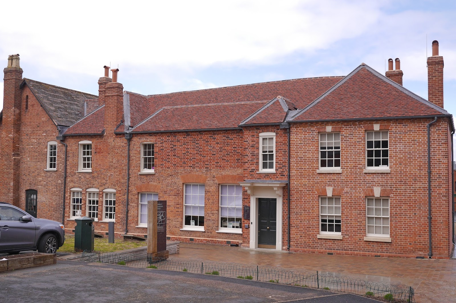
Pevsner observes that there are many attractive houses in the village, and this pair is fairly typical.


The area around the pond was clearly being prepared for an event of some kind, judging by the traffic signs and tents. The imposing house in front of the church is the early 19th century Manor Farmhouse. To the right, the redevelopment of another farm was underway.


We followed a muddy track which climbed steadily out of the village towards Urchfont Hill (215m). We were just on the edge of a hailstorm, but got away lightly. Just before the summit, the Wessex Ridgeway turns left (south west) offering lovely views of the villages in the valley below.


The final section simply followed a track along the ridge for about two miles to reach where we had left the car at the top of Lavington Hill. The views were great, but we were walking into a howling cold wind and it was hard to fully appreciate them.

Conditions: cloudy with some sunshine and hail, windy.

Distance: 6 miles.

Map: Explorer 130 (Salisbury & Stonehenge).

Rating: four stars.

Monday 25 April 2016

Ledbury

The Market Hall

Merv and I headed off for a distant town walk in Ledbury, familiar to him, but unknown to me. We found a nice simple route on the Herefordshire County Council website. The route began at the John Masefield High School (the poet was born in Ledbury, although only lived there until he was about 13). You follow one of the main streets of the town, The Southend, in towards the centre.

Soon you pass the former Girls' School, founded in 1708, but rebuilt in 1910.


At a crossroads there is a spectacular house called Ledbury Park dating from 1590. The close-set timbers are apparently as sign of wealth.


On the opposite corner is a house of about 1600 with the overhanging first floor supported on pillars.


You now enter the High St with another fine timber-framed building on the left: this is the Feathers Hotel of 1560-70. It displays what seems to be a common feature in Ledbury: where the upper storeys are jettied out the ends of the floor beams are protected by a horzontal fascia called a bressummer. I had never noticed that before or heard the word 'bressummer'.


Just past the inn are the almshouses that form part of St Katherine's hospital (of which more later). The left hand or south range, including the tower, were the work of Robert Smirke in 1822. The right hand north range was by William Chick and dates from 1866.


Opposite the almshouses is the wonderful Market House shown at the head of this post. It dates from about 1617. The same William Chick restored it in 1866. The upper part of the building was used as a grain store, while the open section below housed the market.

You take the turning to the right of the Market Hall, Church St and immediately bear left to enter this house at number 1. Externally, it is not especially distinguished, but there is a surprise inside.

The first floor houses a room containing 16th century wall paintings showing flowers and knot designs supplemented by quotations from the Bible. These were only discovered during building works in 1988.


Continuing up Church Lane you pass the interesting Heritage Centre and the imposing Church House, another fine timber-framed building, to reach the church of St Michael and All Angels.


It was built in 1042 and rebuilt in 1140 and again in the 13th and 14th centuries. Some Norman features were retained or relocated - like waht is now the west door in an otherwise gothic facade. I was struck by the undressed stone on the inside of the walls. Adjoining it is a free-standing bell tower: one of 10 in Herefordshire and only 40 in the whole country.The base is 13th century, but the upper parts date from 1732-3. The steward at the church told us, having checked that we weren't Welsh, that the tower was intended to aid defence against marauders from that country.


Now back to the High Street to continue walking along it, with the imposing Barret Browing Memorial Institute on the opposite corner. It was built in 1894-6 by Brightwen Binyon of Ipswich who won the design competition. According to Wikpedia, his design was based on the Market Hall and it does certainly complement it.


We walked uphill now in the splendidly named The Homend, like at a footbal ground.This is a pleasant enough street but nothing much stood out.


Turning left at the top brought us to Belle Orchard, the former Workhouse of 1836.


Returning down The Homend, we noticed that once or two 1890 or 1900 shop fronts had pleasing glazing bars in cast iron with delicate floral motifs - stirrings opf art nouveau perhaps.


Finally, oppoiste the Market House again, we tunred right to find the older parts of St Katherine's Hospital, originally founded in 1232. This is the 16th century Master's House. It looks unprepossessing, and currently houses a public library, but there is another surprise within.


The brick georgian exterior conceals a wonderful timber framed late 15th century hall.


Opposite is the Hall and Chapel of the Hospital. We couldn't unfortunately see inside.


Conditions: cloudy, bright at times, threat of rain.

Distance: maybe 2.5 miles.

Rating: Four stars. A delightful town.

Sunday 24 April 2016

Lyveden New Bield and Oundle

Lyveden New Bield

Ever since we visited the extraordinary Rushden Triangular Lodge almost two years ago, we have wanted to see Lyveden New Bield, also the work of Sir Thomas Tresham. Tresham was a devout Roman Catholic who lived during the reign of Queen Elizabeth I. Catholicism was repressed in that era and Tresham was imprisoned for twelve years on account of his faith. Rushen gave coded expression to his beliefs and Lyveden, also built as a Lodge, was in the same mould.

The house you see today is not so much ruined as incomplete: work started in 1595, but Tresham died in 1605, deeply in debt, before it could be completed. The builders, who could see they weren't going to be paid, simply downed tools and left - and who could blame them. It is remarkable that the house survived.

Rather like Rushden, the house is laden with symbolism, with shield-like panels in sets of three (symbolising the holy Trinity) forming a frieze at ground level and a continuous frieze of seven repeated symbols, each representing aspects of the life of Christ above the first floor windows. The excellent audio guide also mentioned the number five as well (symbolising grace) and the five windows in each bay may be an example.


The house is perfectly symmetrical and is shaped liked a Greek cross, with curving bays at the end of each arm. The cross shape is easier to infer from this photo taken on an angle.


You enter through a servants passage (bottom left in the photo) and arrive in the basement which housed kitchens and other service functions. Looking up it was a surprise to see that the upper floors contained Renaissance doorways - but perhaps Catholics looked to southern Europe more than Protestants did.


It was possible to climb to one of the first floor windows and enjoy the view over the relatively flat Northamptonshire country side. The filed has apparently been sown by the National Trust as a flower meadow, and the mown bits will presumably be paths.


We walked from the house to explore the pleasure gardens starting with this attractive spiral hill surrounded on three sides by a moat.


A path led towards the old Manor House, owned by the National Trust but not open for visiting. You could just glimpse it through a hedge. It looked like the sort of building that might have inspired Charles Rennie Mackintosh: especially the rectangular windows, placed irregularly.


We walked around the edge of the orchard and reached another section of moat, with the house frame between the trees.


After this we simply retraced our steps to the car park and headed off to Oundle for lunch in the Talbot Inn. Oundle is a charming stone town, not quite as imposing as Stamford, but full of character. We parked near Paine's Almshouses (early 17th century) in West St, admiring the obelisks and pinnacles over the entrance door.


At the end of West St, a left turn into New Street brought us to the imposing Talbot Inn, with the buildings of Oundle School beyond.


Up on the right is a further part of the school, looking like an Oxbridge College, which was no doubt the model.


Conditions: bright but quite cold at times.

Distance: maybe a mile and a half - one of the shortest walks I have blogged.

Rating: four stars. Fascinating. It would have been good to have had time to explore Oundle more fully.

Friday 22 April 2016

Peterborough

The Cathedral

I had to go to Peterborough in a hurry to get my Passport renewed, but I turned it into an opportunity to have a good wander round the city. I had always wanted to see the cathedral, but I wasn't too sure what else to expect. I am writing this without my usual copy of Pevsner at my side, so this may be more sketchy than usual.

I parked in Market Street near the Passport Office, possibly not the conventional departure point for a city walk, and headed towards the centre to be immediately confronted with the red and yellow brick neo-romanesque former County Court, now a club.


Across the road (City Road) was a red brick building (Peterscourt) which is now an "eco centre". It almost looks, from the line of chimneys, that could once have been almshouses, but in fact was built in 1856-64 by Sir G G Scott as a teacher training college for men, a role it continued to have until 1938.


At the crossroads with Broadway and Long Causeway, I carried on into Westgate, where a bit of prior research had identified the former Wortley's Almshouses of 1837, now a pub. The Hon Edward Wortley was the MP for Peterborough.

Retracing my steps to the crossroads, I turned left down the pedestrianised Long Causeway to arrive in Cathedral Square. I turned right to face the wonderful Guildhall, built in 1669-71 by John Lovin. Cathedral Square was known as the Market Place until 1963 and the arcaded section was originally used for butter and poultry markets.

Over to the left was this fine shop front which bears the date 1911.


To the right another set of former almshouses can be found: Miss Pears's Almshouses of 1903 on the site of the old House of Correction.


Behind the Guildhall stands the church of St John. It was built in 1407, but heavily restored by John Loughborough Pearson in the 1880s. Pearson removed galleries above the aisles and replaced most of the aisle windows. Later additions include a rood screen in the 20th century.


Turning back towards the entrance to Cathedral Square you find the Great Gate, the entrance to the cathedral precincts, facing the Guildhall. I decided to save the Cathedral until last however and continued along Bridge St.


On the left is the massive red brick Town Hall which dates from 1933. It appears that there are currently controversial plans to relocate Council staff and let out the accommodation. It is mildly curious that the building is called the Town Hall, when Peterborough has been a city since 1541.


I continued down Bridge St to the River Nene and turned left, passing the Old Custom House of 1790, to find my way to the fantastic art deco 1930s Lido which I had seen by chance on my way in.


From here I returned to the Cathedral precincts, checking out a third set of almshouses (seemingly unnamed) on the left, now a Solicitors.


The Cathedral facade (at the head of this post) is unique in its three great arches and dates from 1237 in Early English Gothic. Most of the rest of the building is Norman: construction started in 1118. You enter the nave facing a wonderful 13th century font. This view shows the great arches of the nave and the magnificent painted ceiling. It is the original ceiling which was completed between 1230 and 1250. It is the only one in Britain and one of only four in the whole of Europe. It has been over-painted twice, once in 1745, then in 1834, but still retains the character and style of the original. (Credit to Wikipedia for this.)


The vaulting over the crossing is extremely impressive as well.


For me, the great surprise was to find fan vaulting in the so-called New Building, constructed as a sort of ambulatory around the east end of the cathedral in 1496 and 1508. It is thought that the architect was John Wastell, who was responsible for the magnificent fan vaulting in King's College Chapel in Cambridge.


Conditions: pretty grey, but not too cold.

Distance: a couple of miles.

Rating: four and a half stars.