Friday 28 July 2017

Stoke-on-Trent

The Town Hall

Stoke is rather an unusual city in that it was formed from six towns: Stoke, Hanley, Burslem, Tunstall, Longton and Fenton.  An application for city status was made in 1925, but rejected by the Home Office as it had fewer than 300,000 inhabitants. The decision was overturned after a direct approach was made to King George V who agreed that the borough ought to be a city. The public announcement of the elevation to city status was made by the King during a visit to Stoke on 4 June 1925. (This is one of several examples which contradict the widespread, but erroneous belief that a city has to have a cathedral - see my Cities page.)

It is in consequence rather a sprawling place and I decided to focus on Hanley, which is signposted as the city centre and contains a cultural quarter, which sounded promising. I started this walk in Albion Square opposite the Town Hall. It was in fact  built as the Queen's Hotel in 1869 - and it does rather look like one.

Then down Bagnall St past the imposing Victoria Hall. It was constructed as an annex to the Town Hall in 1888, as part of the celebrations for  Queen Victoria's Golden Jubilee. There is also modern extension (out of shot).


Then into John St and Bethesda St to find the Museum. Main claim to fame is the Staffordshire Hoard.

The hoard consists of a large number of Angl-Saxon metal artifacts  which was discovered in 2009 in a field near the village of Hammerwich in Staffordshire. The hoard was purchased for £3.285 million jointly by the Birmingham and Potteries Museums under the Treasure Act 1996. Here is an example of the cleaned and restored finds.


They are very striking and have been exquisitely restored, but I was disappointed to be honest by the small number and small size of the exhibits on show. Maybe the best bits are in Birmingham? There is also a display at Tamworth castle.

The other main exhibit is a restored Spitfire. The designer of this, dare I say iconic, plane was a local man, Reginald Mitchell.

Opposite the Museum is what looks like a pub, with beautiful decorations. It was raining really hard now and I had to take my picture from under an awning outside the Museum. I couldn't take the main facade which was even more beautifully decorated.


Round the corner was the extravagant Bethesda Church, with a lovely art deco building next to it.


 The nave of the church, seen from the Museum again, had very attractive brickwork.


I then walked along Pall Mall and was delighted by the terracotta decoration on this pub.


Then up Piccadilly to find an extravagant art deco shop on the corner.


Now round the corner into Tontine Square where the former Market Hall of 1831 is now a combination of Waterstone's and Wetherspoon's. The pub turned out to be the Reginald Mitchell. A nice coincidence.


 Nearby was another splendid pub ...


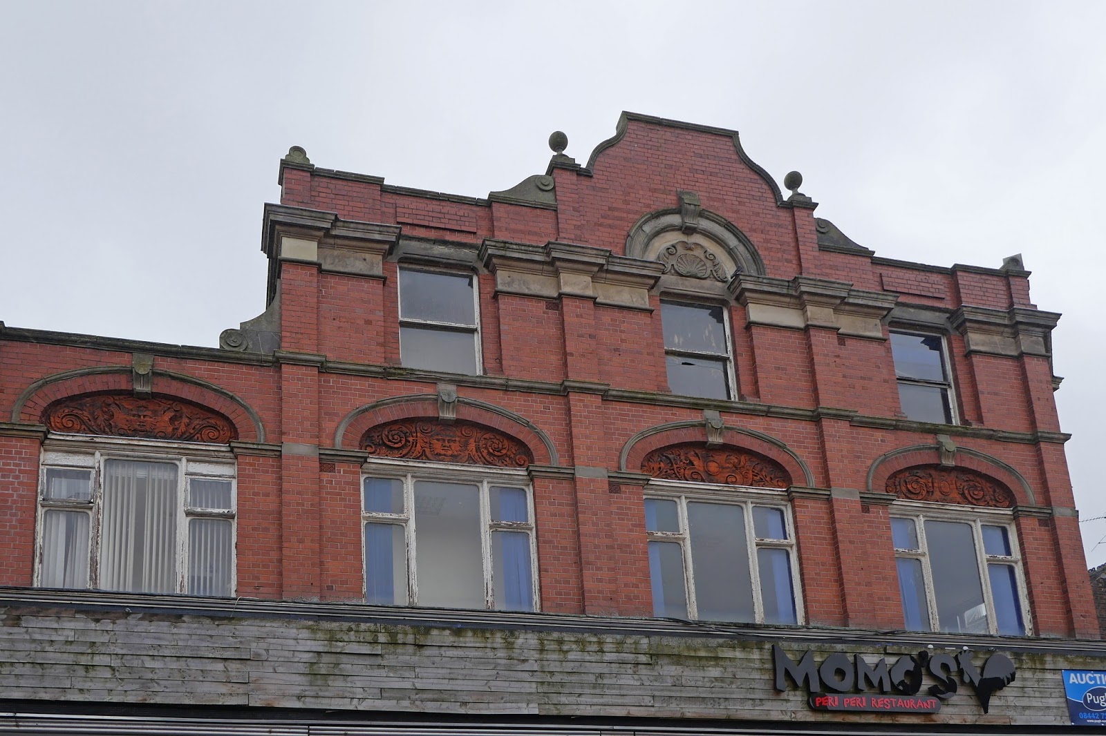
... and, shortly afterwards, a house with wonderful brick decoration under the eaves.

It was now raining very hard and so I abandoned any further efforts at exploration.

My overall impression was of a city which has not looked after its (mainly 19th century) heritage very well. Most of the streets have a jumble of buildings from different periods and there is no coherent centre. It feels like a town rather than a city.

Conditions: wet and grey, cool.

Distance: maybe a mile and a half.

Rating: three stars.

Thursday 27 July 2017

Knutsford and Tatton Park

St John the Baptist church

I started my walk around Knutsford at the imposing Georgian church of St John the Baptist (1741-4, by J Garlive) and continued along Church St to reach Toft Road and the rather lovely former Town Hall, now a wine bar / restaurant. It was the work of Alfred Waterhouse (National History Museum, Manchester Town Hall) and dates from 1870-2.


Continuing south along Toft Road, on the right the Court House hotel. This was once the Sessions House (1815-8, by Thomas Harrison). It is quite imposing, but too heavy for my taste. According to Pevsner, the gaol was once just round the back - very efficient!


Left at the traffic lights and down Adams Hill past the station to reach the start of King St, Knutsford's main and most characterful street. On the opposite corner was the former public library of 1904, now a nursery school. (A bit of a pattern is emerging here, no doubt not uncommon.)


King St is a very attractive street with an interesting miscellany of houses. I liked this half0timbered group on the left hand side.


A bit further up on the same side is the surprising Gaskell Memorial Tower. It was built for Richard Harding Watt  in 1907 in honour of the novelist Mrs Gaskell. I rather liked small the art deco tower beside it.


Now on the right was the Gusto restaurant (formerly Est! Est! Est!). This is a building of no special merit except that my wife and I had our first date here.


Next was the nicely decorated entrance to the Royal George Hotel.


And finally, Marble Arch - once a coaching inn, but now offering a picturesque view through the archway.


I continued northwards to reach the entrance to Tatton Park, Kutsford Lodge (1810). Tatton was owned by the Egerton family from 1598 to 1958 when the last Lord Egerton died without an heir. It passed to the National Trust and is now the responsibility of Cheshire East Council.


I followed a track passing close to Tatton Mere, apparently an actual mere rather than the artificial creation of a Capability Brown.


Way off to the left I had my first glimpse of the house (now called the Mansion).


A very pleasant path through the parkland eventually provided a close up view. The house was designed by Samuel Wyatt and started in 1788 but not completed until after 1807. I am not much of a fan of neo-classical architecture and I confess I found it uninspiring.


The main entrance seemed even more so, but I loved the fallow deer grazing on the grass opposite.


Time was up and I made a brisk return to Knutsford along the long drive back to Knutsford Lodge. There was just time to spot this handsome red deer.


Conditions: mild, threat of rain.

Distance: 6 miles.

From: Discover Cheshire website

Map: Explorer 268 (Wilmslow, Macclesfield & Congleton)

Rating: four stars.

Friday 14 July 2017

Lynton to County Gate (South West Cost Path 101)

 Lynmouth Bay and Foreland Point from Lynton

We set out from our hotel in Lynton and, perhaps controversially, took the wonderful funicular down to Lynmouth.


The funicular is water-operated, 862 feet (263 m) long, operating on a 1 in 1.75 gradient track. One car descends, while the other ascends, on a counterbalance system. The water is piped from the West Lyn River. It was opened in 1890 (information from Wikipedia).

We walked past the small harbour with its lovely Rhenish tower.


Soon the path took us into woodland to begin the long climb out of the town. After some zig-zags the path emerges onto the cliff side just below the road and the ascent continues, offering fine views over Sillery Sands.


Just before you reach the church of St John the Baptist at Countisbury (an 18th-19th century rebuilding of an older church) there is a great view of the shoreline of Sillery Sands.


 The church enjoys a wonderful position.


The path levels out for a while as you walk above the grey sand beach. Then you start climbing again to pass just under the summit of Butter Hill (302m) where there are some lovely views back to Lynmouth/Lynton.


Now there is a bit a descent and then the path winds inland behind the great bulk of Foreland Point. There are great views down Caddaw Combe towards South Wales.


We followed the path on the right and then descended to the bottom of the valley and climbed again behind the coastal cliffs.


At the top we can see east as far as Hurlstone Point.


Once we entered the next zone - Glenthorne Cliffs - there was a fine view back towards Foreland Point.


The path which continued through Glenthorne Cliffs was predominantly woody with the path winding along a mid-cliff level around a series of combes. Just before Wingate Combe, we passed the worryingly named, but unimpressive, Desolation Point, photographed into the sun unfortunately.


After this, the path continued on the same line but now with the slopes mainly covered in rhodendrons. At length we emerged through a rather wonderful gate (note the pigs on the top) and realised that we had been walking through the grounds of Glenthorne House.


I haven't been able to discover much about this mysterious house except that it is Neo-Tudor house built 1829-30 for the Reverend Walter Stevenson Halliday. I would love to know the story behind the pigs' heads.

We headed uphill through woodland to pass this intriguing cross.


From here, a grassy track led uphill to the A39 and the boundary between Devon and Somerset. The County Gate car park is off to the right.


Conditions: Warm and sunny.
 
Distance: 6.2 miles.
 
Map: Explorer OL 9 (Exmoor).
 
Grading:  Moderate to Strenuous.
 
Rating: four and a half stars. Dramatic at first. The area around Foreland Point was wonderful. A bit more mundane later, but always enjoyable.

Thursday 13 July 2017

Hunter's Inn to Lynton (South West Coast Path 100)

The Hunter's Inn

We set out from the Hunter's Inn and re-traced the last part of yesterday's walk before resuming the Coast Path at the bottom of the Heddon Valley. Soon we came to the stone bridge over the River Heddon and began the long climb up the other side of the valley.


As we approached Heddon Mouth, there was a great view down to it.


At the top we passed inland of Highveer Point and had our forst view of the next section of coast, bounded by Foreland Point in the distance. Lynmouth and Lynton lie in the bay before it.


As we advanced, we noticed this interesting holed rock.


Now we were forced inland and were delighted to come on this waterfall.


The next section was through woods, but eventually a nice view across Woody Bay presented itself.


We joined a tarmac track inland through the small settlement of Woody Bay and left it at this rather wonderful sign, now heading towards New Zealand!


Soon there was a choice between a road option and a track option. Naturally, we took the latter and headed down towards the coast again. It was surprising how overgrown the field path was. After a while we began to glimpse this watch tower on the hill over Crock Point and eventually managed a half-decent pic of it.


We descended into the hamlet of Lee and enjoyed refreshments at the delightful cafe in its lovely garden. The route continued up the hill and past Lee Abbey, a Christian community, not an actual abbey.

The site was originally owned by the Cistercians at Forde Abbey and seems to have been rebuilt or extended in Victorian times. In the 1920s it became a hotel, at which time the main extensions were built. During the Second World War it became a boys' school, and in 1945 was acquired by the Christian Fellowship.

Just as you leave the Abbey grounds you enter the extraordinary Valley of Rocks. There is a curving rocky slope on the landward side, parallel to the sea and two very dramatic rocks on the seaward side. The OS map names them as Castle Rock and Rugged Jack, which seems pretty reaonable.


The far side of Castle Rock has some vaguely human or animal shapes: the one on the right suggested a Teenage Ninja Turtle to me.


Rugged Jack was truly impressive - note the small figures on the left hand side.


Now we followed the tarmac path which leads to Lynton for about a mile. It clearly offered a delightful excursion from the town. There was some evidence of goats on the path and just towards the end we discovered one of the culprits.


We were staying in a hotel right on the path so the walk ended soon afterwards.

Conditions: Warm and sunny.
 
Distance: 7.3 miles.
 
Map: Explorer OL 9 (Exmoor).
 
Grading:  Strenuous.
 
Rating: four stars. Started and finished really well, but the section around Woody Bay was less enjoyable.