Wednesday 30 October 2013

Bradenham and West Wycombe

St Botolph's church, Bradenham

After an interesting stroll around High Wycombe this morning, I carried on into the Chilterns for a bit of country. A study of the map suggested that a circular walk from Bradenham to West Wycombe would be good, so I duly parked at Bradenham near to the church. It is mainly Victorian, but the tower is impressive.

Just to its right is the splendid Jacobean Manor House, which Pevsner dates to about 1670. It is now owned by an accountancy firm.


In front of both is a vast village green, the upper part of which contains - as it should - a cricket pitch. I followed the road down the hill and passed this extravagantly crenellated house, the 18th century Gothick White House.


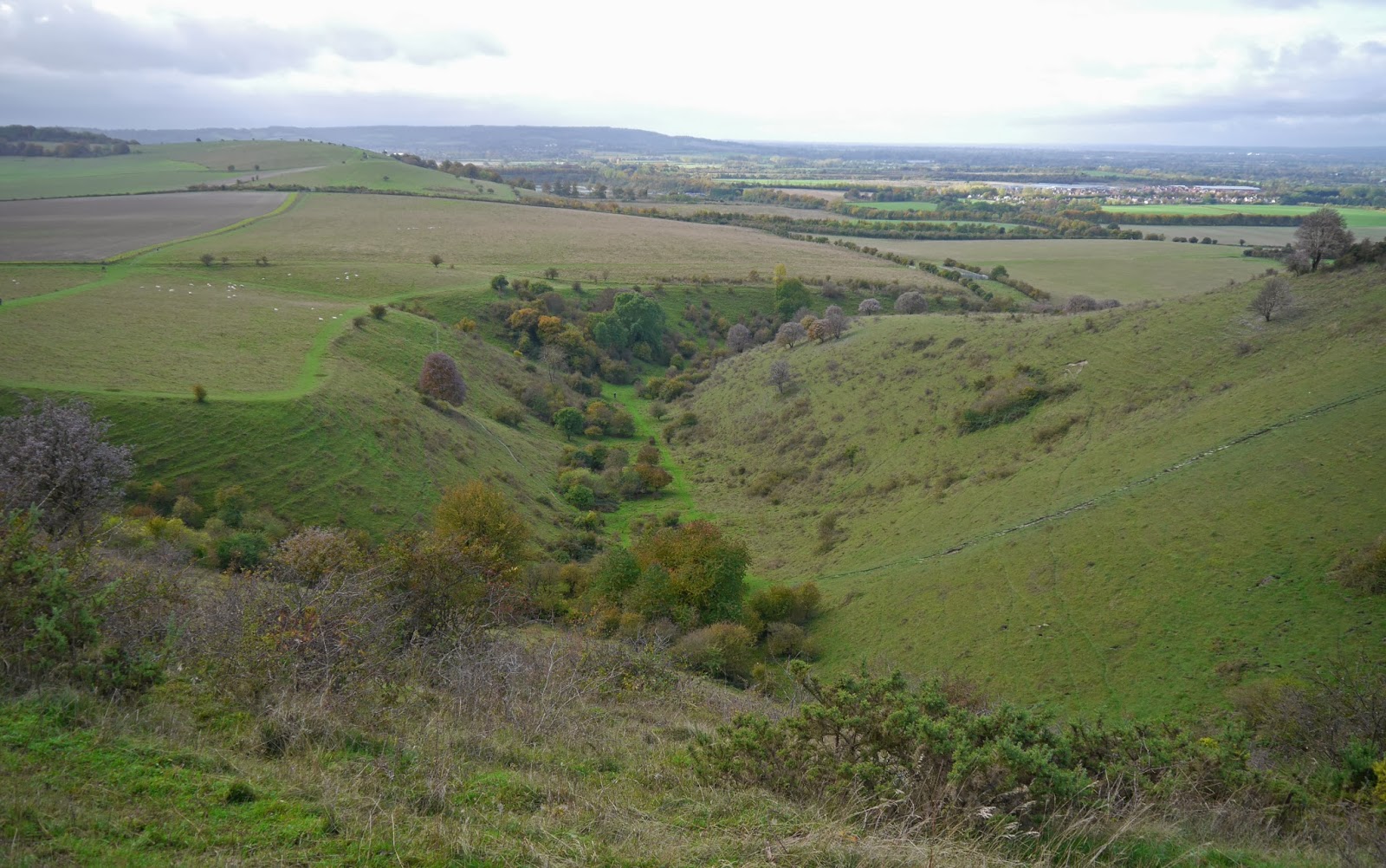
At the bottom of the hill, which is also the bottom of the valley, I crossed the road and climbed up the slope to the wooded ridge on the other (west) side. On the way up, there was a nice view back towards Bradenham.


Reaching Nobles Farm, I turned left and followed a track through light woodland all the way to West Wycombe Hill. On the way I saw an optimistic Emperor Dragonfly flying hopefully around a large puddle. Overhead, the plaintive cry of Red Kites was a constant companion.

The most instantly striking feature of Wycombe Hill is the church of St Laurence.


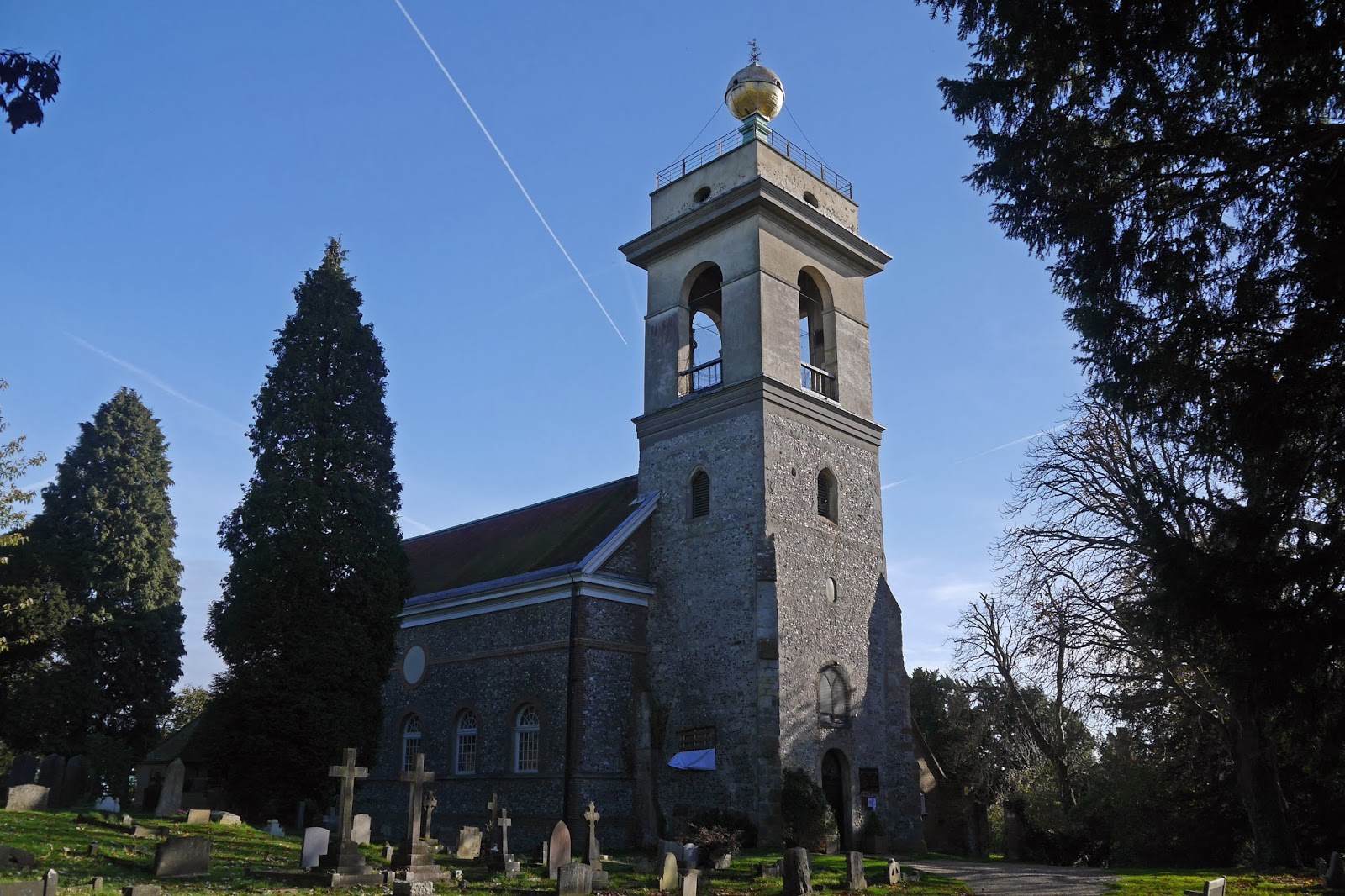
The immediate impression is of a Georgian church tacked on to a much older tower, which itself has a must later upper storey with a mysterious golden ball on the top. There is also a 14th century chancel beyond the nave, which was indeed rebuilt in a Georgian style in the mid 18th century. The rebuilding was the work of Sir Francis Dashwood, Baron le Despencer and creator of the nearby West Wycombe Park. Dashwood is better known for being a founder of the notorious Hellfire Club.

Just behind the church is an even more surprising structure. It is hexagonal and open to the sky (and currently being restored, so only visible from the back). It is a memorial to Dashwood's friend George Duddington, a fellow Hellfire Club member.


The architect was the wonderfully named John Bastard, who I have met before as the architect of the rebuilding of Blandford Forum after the great fire of 1731. I couldn't resist a close up of the golden ball as I left the churchyard.


There was a nice view across to the east side of the valley as I headed downhill.


I found some difficulty locating the path to the valley bottom and emerged midway down the hill and had to circle round the edge of a vast field before finding the cross-field path


On reaching the road, the A4010, I walked under the railway bridge and decided that I had insufficient time to climb the other side and return to Bradenham through the woods, and so settled for following the road back. I had thought this might be a good day to see a late season butterfly and lo! just the other side of the bridge I saw a Peacock, which was very cheering.

Conditions: mostly bright and sunny, some cloud.

Distance: I ended up walking about five miles.

Map: Explorer 172 (Chiltern Hills East).

Rating: three and half stars.

High Wycombe

The Guildhall

We passed through High Wycombe last Saturday on our way to start the Ridgeway at Ivinghoe Beacon and I realised that I had never really looked at it as a town in its own right, it was just somewhere en route to somewhere else. So today, with good weather in prospect, I decided to have a look around. I parked in the massive Eden Centre shopping complex and largely by lauck managed to park near the exit to the towncentre, emerging rtaher incongrously close to the magnificent Guildhall.

This dates from 1757 and was designed by Henry Keene. It was built on the site of an earlier Guildhall of 1604. Pevsner describes it as "charming".

I had decided to follow Pevsner's "perambulation", aware or course that as it was written in 1960 things could be different. I headed east towards the High St, stopping immediately to admire the Market Hall.


This is also dates originially from the 17th century, but was rebuilt by Robert Adam in 1761 - "not one of his masterpieces" says Pevsner. Maybe, but it is certainly interesting and unusual. The distance signs above the arches indicate that this was once the main road from London to Oxford.

As you continue along the wide and now pedestrianised High St, there is a great view back to the Guildhall as it projects out into the road.


The High St is pleasant enough, but with more modern elements than in Pevsner's day. At the end, I continued into Easton St and enjoyed this ambitious, presumably late Victorian, building. It is one of those that the architect has thrown everything at. The doorway is especially extravagant.


Towards the end of the street is the former Royal Grammar School of 1873. Very picturesque in red and cream brick, it is now an insurance office.


Right in front of it, is what must be Wycombe's oldest building, the "bedraggled remains" (Pevsner - I can't disagree) of St John's Hospital dating back to 1180. This was a classic medieval hospital where a small body of monks or nuns looked after both local people who were poor or sick and wayfarers in need of shelter. Such hospitals are seen as the forerunner of almshouses.


The part that remains is the infirmary hall. There would also have been a chapel and cells for the monks around a courtyard. The hospital was closed during the Dissolution of the Monasteries (I have only recently understood that all monastic buildings were affected, even ones doing such good works as this one) and acquired by the town for use as a school. When this was rebuilt in 1873, most of the original buildings were knocked down. One might ask why?

This was the extent of my eastern walk and I retraced my steps along Easton St to turn left into Queen Victoria Street, where the excellent Edwardian Town Hall of 1903 stood out like a beacon among the drab 1930s buildings that surround it, especially the extremely dull extension.


Pevsner now describes a walk along St Mary's St round to Church St. This has all much changed, but the large church of All Saints is still very  much in evidence.


It is medieval in origin, but the fine tower is "a very pretty piece of early Gothic revival" (Pevsner again) of 1755 by Henry Keene (he of the Guildhall). Most of the rest is Victorian restoration.

I carried on into Frogmoor, a rather depressing area showing the economic consequences of the massive Eden Centre: empty buildings and bottom of the market shops.

Finally, returning to the car park, I was delighted to see the Millenium Clock. It is a simplified version of the clocks built all over the country in honour of Queen Victoria's jubilees.


Conditions: sunny.

Distance: two miles.

Rating: four stars. Full of interest. Ideal for a short stroll.

Saturday 26 October 2013

Ivinghoe Beacon to Wigginton (The Ridgeway 1)

 View north from Beacon Hill

Today we begin our latest walking project with our friends Merv and Pud: The Ridgeway. We have done small sections of it as part of the Berkshire Way and I have wanted ever since to do the whole thing.

The Ridgeway starts officially at the top of Beacon Hill near Invinghoe. So the first challenge is to climb to the top of the 233m hill. We started from the layby to the north and after a struggle with the slippery chalk path soon had a lovely view over Gallows Hill to the east.


There was also a nice view north towards (I think) Edlesborough, whose church of 13th century origin stood out in the morning sunshine.


The path heads south along a grassy ridge to pass Incombe Hole, a lovely combe, on the right.


The signs were rather absent here but we eventually decided to take a right fork along a further grassy track and soon enjoyed a view to the west with St Mary's Ivinghoe in the foreground ("a big and noble church" according to Pevsner) and Mentmore Towers bright just below the horizon. It was was built between 1852 and 1854 for Baron Mayer de Rothschild by Joseph Paxton. Later owners have included the Maharishi Mahesh Yogi, who enchanted the Beatles.


A bit further on, at Pitstone Hill, there was an excellent view back to Beacon Hill on the left of the picture.


Now we skirted the gassy slopes of Aldbury Nowers, where you can apparently see 30 species of butterfly in the summer on the west-facing slopes. I fancy I might come back next year.


The route then leads down to Tring railway station, which is at the end of a 2.5 mile cutting through the Chilterns. We admired the Posting House, the former Royal Hotel.  The London to Birmingham railway Line was opened in 1837 and the hotel was opened the following year. It has now been converted to flats.


A little further on we crossed the Grand Union Canal. This too is in a long cutting through the Chilterns. It was opened in 1797 as the Grand Junction Canal. I had always imagined that the Grand Union was built as a single long canal from London to Birmingham, but a comprehensive Wikipedia entry explains that it came into being only only in 1929 and was formed from the amalgamation of several different canals.


From here, we climbed up through Chestnut Wood, crossed a bridge over the A41, still climbing, and soon reached the outskirts of Wigginton where we ended our first leg. We adjourned to the Greyhound pub in Aldbury, where we enjoyed an excellent lunch.

 Conditions: cloudy, threat of rain.

Distance: 5.3 miles.

Map: Explorer 181 (Chiltern Hills North).

Rating: four stars. A great start, but tailed off towards the end.

Wednesday 23 October 2013

Newbury

The Town Hall

I know Newbury reasonably well, but I was surprised to discover in a book on the subject that there are a number of groups of almshouses, a special interest of mine. I decided to do a town walk and developed my own route to take in as many almshouses as I could identify. I decided to start at the Clock Tower at the top of Broadway. It dates only from 1929 - I would readily have believed it was Victorian.

Down Broadway, into Northbrook Street, with many impressive 18th and 19th century facades above the shopfronts, over Newbury Bridge and left into Mansion House St towards the Market Place. On the right is the Municipal Building of 1908, which replaced the old Mansion House when the road was widened. The Town Hall itself dates from 1876-81 and is reminiscent of Waterhouse's one in nearby Reading.


The Market Place leads to the Wharf which boasts the timbered-framed Cloth Hall of 1626-7, the "most interesting house in Newbury" according to Pevsner, and now the town Museum. Sadly for me it is currently shut for refurbishment.

In the Market Place itself the other really notable building is the Corn Exchange of 1861. There are also some nice old pubs.


I left the Market Place via Cheap St and passed the former public library of 1902, now a restaurant. It has some very pleasing art nouveau style glass panels in the windows.


Then along Market St and into Bartholomew St, with the massive Oddfellows Hall of 1886 in Craven Road to the right. It is now flats.


Further along Bartholomew St there is the empty Eight Bells pub, which dates back to the 16th century.

At the junction with Pound St, Argyle St is over on the right and this contains a remarkable group of buildings. On the left is St Bartholomew's Hospital, an almshouse originally founded in the 12th century, but whose current buildings date from 1698. It looks a little worse for wear and older photos show a clock above the stone plaque announcing its name.


Opposite is a building called St Bartholomew's Manor House. Pevsner says that the facade dates only from 1927-8, but that the house behinds goes back to Tudor times.


Further along on the right are the Essex Wynter Almshouses. Originally a farm, they became the Phillip Jemmet almshouses in 1670 (and his initials can be seen over the door) and were reconstructed (having become derelict) in 1929.


Round the corner are the Upper Raymond Almshouses of 1826. They consist of a plain brick terrace, but with dramatically large chimneys, gothick windows and a curious shallow stone arch stuck on to the centre of the block.


Nearby are the very plain Lower Raymond Almshouses, bearing the date 1796. Another range at right angles to this one was destroyed in by bombing 1943.


The contrast between these two groups of almshouses is interesting. Alsmshouses were effectively an early form of social housing, but they almost have a higher level of architectural ambition than is found in workers' cottages of any period and housing estates of the Victorian or later periods. The Upper Raymond ones fit this pattern, but the Lower Raymond ones don't. I wonder why.

I retraced my steps towards the town centre, this time taking Bartholomew St to reach St Nicholas church. This fine Perpendicular Gothic church dates from about 1500-32.


Now long West Mills, with a very pleasing collection of houses of various ages beside the Kennet and Avon canal, some of which were once almshouses.


I walked along the other side of the stream to reach Newbury Lock and another view of the church. This marked the effective end of the walk.


Conditions: bright and sunny, with odd bits of cloud.

Distance: about 3.5 miles.

Rating: four stars.

Tuesday 15 October 2013

West Parley to Wimborne (Willett Road) (Stour Valley Path 2)

The Stour near Dudsbury

We started the Stour Valley Path in August and today offered an opportunity to continue with it. We picked up the route at the Dudsbury pub in West Parley and followed a path towards the iron age hill fort of Dudsbury Camp. You would never guess that now as it is a flat grassy area with a girl guide camp on it. Once you pass by however you can see that it is in indeed on a hill.

The first glimpse of the Stour now presents itself (above) and the path continues with a golf course on the right. You cross the A348 and pass the weir and water works at Longworth to then skirt the pleasant Longham Lakes reservoir.


We then followed a field-edge path, which our guide book (The new Stour Valley Path by Edward Griffiths - 1998, but still very usable) explains was once a river terrace when the Stour carved its way through the flat countryside.


This leads to Hampreston and the churchyard of All Saints. The tower and nave date from the 1400s.


Just beyond the church, the village school seemed to have the hall marks of the Lady Wimborne cottage that we see all over the Poole/Wimborne area, and next door are a pair of them. They had
however sadly been altered, with modern replacement windows. There were 108 Lady Wimborne cottages. They were built for workers on the Canford Manor estate from 1867 onwards. The work was started by Charlotte Guest, wife of Sir John Guest, an iron magnate, and continued by her daughter in law, Cornelia, Lady Wimborne (the Guest's son Ivor was made Lord Wimborne in 1880).

We now followed a busy road to eventually turn left for Little Canford, soon passing the picturesque gatehouse of Canford Manor.


We had seen quite a few butterflies (Speckled Wood, Red Admiral, Small Tortoiseshell, Peacock) and several dragonflies, and as we approached the Fox and Hounds Inn an Emperor dragonfly consented to be photographed.


After a pause for refreshments at the excellent pub  we walked across fields to finally see the river again. Here it was shallow and often choked by plants. As we passed Canford Magna on the other bank, the towers of Canford Manor (now Canford School) came into view. The main tower was the work of Sir Charles Barry junior, son of the architect of the Houses of Parliament.


Then we reached the exquisite suspension bridge across the river. The bridge is 120 years old and a major refurbishment was only completed earlier this year.


The river upstream was now wide and deep.


Once on the other bank, we detoured to see the delightful gate (Lady Wimborne again) to Canford School.


And the adjacent parish church which dates back to the 11th century; the tower is Norman.


We retraced our steps to follow Lady Wimborne's Drive - the carriage drive from Wimborne to Canford.

This is a very pleasant track, but it seemed odd to not be walking along the towpath by the river, which was just to our right through the trees. Still, this seems to be shaping up as a Lady Wimborne walk, so perhaps it is right.

We passed under the busy A31 and soon came to the truly wonderful Lady Wimborne railway bridge (who else?). It dates from 1876 and is looking in need of renovation, but it surely must be one of the most ornate bridges to simply carry a railway line. I have seen gates of major cities which are less impressive.


At the end we emerged through a turnstile (!) and went past another Lady Wimborne house, which unusually is also entered via a turnstile.


Finally, we walked through a suburban housing area to then follow line of the river back to where we left the car, at the end of Willett Road. This last section coincided with part of the route of our previous Wimborne route, in August 2011. 

Conditions: sunny and surprisingly warm.

Distance: 7.75 miles. Distance now covered 18.75 miles.

Maps: Explorer OL 22 (New Forest) and118 (Shaftesbury and Cranbourne Chase).

Rating: four stars.