Sunday 24 November 2013

Tintern

Tintern Abbey

We were guided by cousins Ruth and Jon on this fascinating walk from the imposing ruins of Tintern Abbey. The abbey was founded in 1131 and is the second oldest Cistercian abbey in the Britain (only Waverley in Surrey is older). The original buildings would have been austere, but the church whose remains you now see is the result of a grand reconstruction which began in 1269. By the time the abbey was dissolved in 1536 it was the wealthiest in Wales.

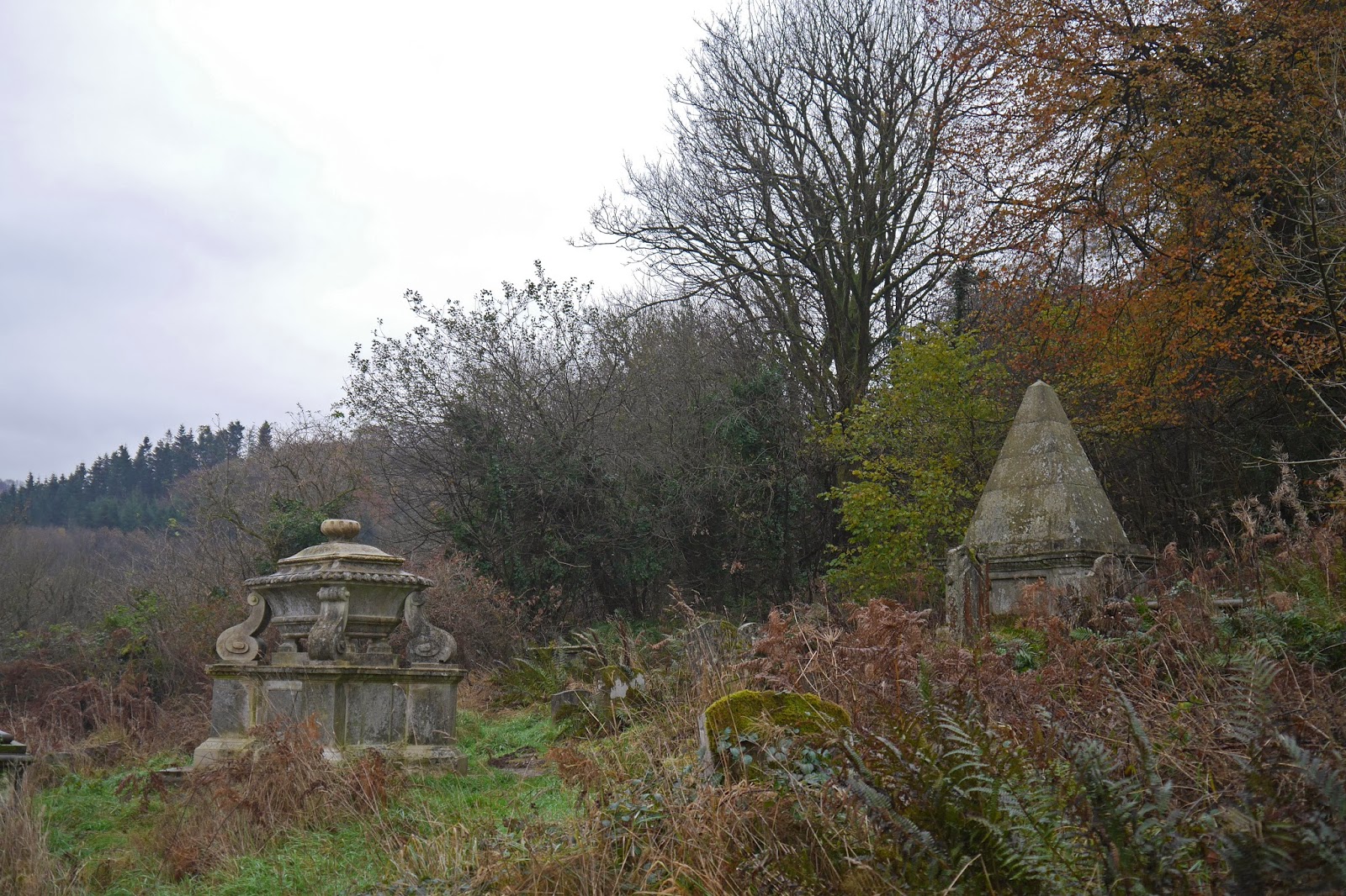
We walked away from the abbey, crossed the road and climbed up to more ruins, those of St Mary's church built in 1866 to replace a medieval chapel and burnt down in 1977.


The sloping churchyard contains some impressive 18th and 19th century graves.


A series of narrow paths led us through scattered houses and we especially liked the oriental statues on the gateposts of one of these.


We entered some nice beechwoods on one slope of the Angidy River valley ...


... and descended to a small bridge over the river.


This river valley developed as an important industrial centre from the late 16th century and there were numerous water-powered works along its route. The most conspicuous now is the abbey bast furnace, where the location of the water wheel is readily identifiable.


We walked up through Buckle Wood to a hamlet marked on the map as Fairoak and then along the road and across fields to reach the Gare Hill WT station at 260m above sea level. There was a great view, unfortunately very grey and hazy today, down over the Severn, with both the Old and the New Severn bridges clearly visible.


We retraced our steps and now enjoyed a splendid view towards the Wye valley.


As we descended towards the valley we passed the tiny church of St Mary's at Penterry. The walls are medieval but the porch and bellcote are the result of a Victorian renovation. On the north side there is a medieval leper window, a lancet at a low level that allowed lepers to view services without coming into contact with other members of the congregation.


After crossing some fields, we descended through Limekiln Woods, soon passing the eponymous lime kilns. These ones were used from the 1700s until 1902.


Scrambling up the bank of the sunken track allowed me this view of the abbey as we approached


We also saw this intriguing and mysterious fungi.


And finally some mummers (?) were performing outside the Anchor Tea Rooms, which provided an unusual end to a very interesting walk.


Conditions: cloudy, grey, cold.

Distance: 5 miles.

Map: OL 14 (Wye Valley & Forest of Dean).

Rating: four stars

Tuesday 19 November 2013

London: Inns of Court

King's Bench Walk, Inner Temple

 I was in London to have lunch with a friend and decided to do this walk around the Inns of Court, taken from London's Hidden Walks book 1 by Stephen Millar. This is an exceptional walk book with detailed accounts of each walk. Rather than repeat all that, I will simply pick out the things that most interested me.

You start at Blackfriars and walk along Tudor Street to enter the seemingly vast expanse of the Inner Temple. The imposing King's Bench Walk stretches out on either side of the gateway. It dates from the 1670s and was designed by Wren.

I was especially keen to see the celebrated Temple church and headed straight there. The round church, modelled on the church of the Holy Sepulchre in Jerusalem, was consecrated in 1185 and the nave was added in 1240.


The inside is light and airy, the original round section being exceptional beautiful.


The route continues along Middle Temple Lane to reach Middle Temple Hall, a handsome building dating from Elizabethan times (1573).


Now you double back to emerge suddenly into the bustle of the Strand. George Edmund Street's magnificent Royal Courts of Justice is just to the left.


Now up Chancery Lane and left into Carey Street, where in a side street is one of the more unusual sites of this walk: an original Victorian public toilet.


Further along Carey Street is the entrance to Lincoln's Inn. This is the more elaborate view of the gate from the inside.


In the far corner is the dramatic Great Hall (left) and Library (right), opened by Queen Victoria in 1845.


While on the right there is the Old Hall built in 1490, which was once used as a law court.


You exit through an arch next to the Old Hall and then go through the rather plain Gatehouse of 1564 into Chancery Lane. Emerging into High Holborn you would normally paused to admire the half-timbered Staple Inn, although it is currently hidden behind scaffolding. I have walked past this building many time and it was pleasing to now know what it is.

Heading briefly west you pass the old Cittie of London pub and enter Gray's Inn, with the chapel dating from 1689 ahead.


Turning through an arch on the left you come to Gray's Inn Gardens, known as "The Walks", a delightful area open to the public, as are other gardens in the Inns of Court, at lunchtime.


Leaving Gray's Inn, you cross High Holborn to reach Lincoln's Inn Fields, London's largest square at 12 acres. It was laid out by Inigo Jones in the 17th century. One of the most interesting buildings is the extraordinary Sir John Soane's museum.


Leaving on the opposite side you pass the Old Curiosity Shop in Portsmouth St. This dates from the 1560s and is one of the oldest hops in London, but the link to Dickens may be opportunistic rather  than real.


Finally you emerge in the Strand and I will end with one of my favourite London churches, St Mary le Strand by James Gibbs (1727).


Conditions: cold but bright and mainly sunny.

Distance: 3 miles.

Rating: four stars. A very interesting look at an area I have passed through many times but never before explored.

Sunday 17 November 2013

Wendover to Princes Risborough (The Ridgeway 3)

The Red Lion, Wendover

We resumed The Ridgeway on a very misty morning, picking up the route in the centre of Wendover and walking up the hill past some very attractive cottages. Further along we left the road to climb Bacombe Hill and then carried on up the 260m Coombe Hill. At the top is a monument which was erected in 1904, by public subscription, in memory of 148 men from Buckinghamshire who died during the Second Boer War. It is one of the earliest examples of a monument to the fallen, rather than to commemorate a victory.


There is apparently an excellent view from the top, but we could see nothing and so headed swiftly south along the side of the ridge to cross a road and enter a large area of woodland. The beech woods of Goodmerhill Wood were a delight to walk through.


At the end of the wood we crossed another road and entered the grounds of Chequers. It dates from the mid 16th century but has been much altered since and was given to the nation by Lord Lee of Fareham in 1917 to be used as a country retreat for the Prime Minister of the day. You can't see much of it - reasonably enough - as warning signs require you to keep to the outer edge of the park.

After crossing the main drive, you climb across a field and into more woodland. Just before you enter the wood there is a nice view across the fields with the roof of Chequers visible on the left and the Boer War monument just discernible on the end of the ridge.


We saw an especially fine tree as we left the next section of woodland.


Later we emerged into an open area, with farm buildings out of shot on the right, where a winding path led towards a lovely selection of autumn trees.


This brought us to Pulpit Hill where there was a great, but indistinct, view south west over Princes Risborough, with Wain Hill in the background.


We meandered our way down, passing the popular Plough pub at Lower Cadsden and then skirting Princes Risborough along the line of a former railway. We ended this leg when we hit the A4010. From the map, I had thought the Ridgeway turned right here, but the signs pointed left. We have found a number of discrepancies between the map and the signposts and have decided on a policy of the signs being the definitive route.

We had therefore bypassed Princes Risborough, but before we started I had a very brief look at the centre and took this picture of the Town Hall of 1824 located in the centre of the Market Place.


Conditions: misty, drizzle, clearing somewhat as the walk progressed.

Distance: 6.5 miles (18.3 covered so far).

Map: Explorer 181 (Chiltern Hills North).

Rating: four stars, but more for its potential appeal than today's walk which was rather frustrating.

Wednesday 13 November 2013

Abingdon

The Market Place from the High Street

Abingdon has claims to be the oldest town in England, and it also has five sets of almshouses. I wonder why I have not previously done a town walk here, but today here I am. I start from the Market Place, which is dominated by the Old County Hall (Pevsner calls it the Town Hall), a wonderful building of 1678-82. It was built by Christopher Kempster, who was one of Wren's City masons; it is not known if he also designed it.


To the left is a delightful group of buildings. On the left is St Nicholas Church: the door is Norman, but most of the rest is later and it was restored in 1881. The building to the right was once the hall of the Hospital of St John, a medieval hospital caring for the sick, the poor and travellers alike. I saw a ruined version of the same thing in High Wycombe only a couple of weeks ago. In between the two is the 15th century gateway, which is almost all that remains of the great abbey founded here in 675.


I headed through the gateway, passing on the right the one-time entrance to the grammar school founded in 1563 in the former hospital buildings by John Roysse.


At this point I was following a walk with picture clues that I found on the Friends of Abingdon website. It now took me through the pleasant Victorian gardens on the the abbey's religious buildings and then on a less rewarding loop past Waitrose supermarket and through some new housing developments. I did see the Mill Stream however and eventually emerged by the restored domestic buildings of the abbey, with a 13th century chimney.


On the right of the photo a narrow passageway, or slype, can be seen and leads quite soon to the river Thames and Abingdon's medieval bridge (1416, but mostly rebuilt in 1927). This is the view from the far bank.


The view down river is equally pleasing, with the prominent spire of St Helen's church.


Retracing my steps towards the town, I found a good viewpoint to take a picture of the old Gaol, which dates back to 1805-11. It features an octagonal centre with radiating wings as required by the penal theories of the time. It is now being converted into apartments, alongside "a cafe and restaurant quarter".


Now up Bridge St and left into the attractive East St Helen's St, the best in Abingdon according to Pevsner, with a nice medley of old houses. Entering the churchyard of St Helen's, you are confronted by an extraordinary sight of three sets of almshouses: "No other churchyard anywhere in England has anything like it" (Pevsner).

On the right are Twitty's Almshouses of 1707.


In front of you, are the extraordinary Long Alley Almshouses, which date from 1446. The front doors are accessed via a long pentice, or cloister walk.


To the left are the Brick Alley Almshouses, built for Christ's Hospital in 1718. The giant arches carry first floor balconies.


The church itself takes up the final side of the churchyard. The 13th century steeple seen earlier from the river bridge turns out to accompany a massive church, rebuilt in the 15th and 16th centuries to have double aisles on each side of the nave.


The final stage of my exploration involving walking up West St Helen's St and turning left into Ock Street. A small detour revealed part of the fine old brewery, now apartments.


Further along Ock St are the fourth set of almshouses: Tompkins's Almshouses of 1733. The Dutch gables mark the ends of two ranges of houses which face each other across a small but pretty courtyard.


I retraced my steps back to the Market Place, pausing to note the Baptist church of 1841, with its fine Tuscan columns and portico.


Finally, I found my way to Vineyard for the final set of Almshouses, St John's Hospital, re-established here in 1801.


Conditions: a beautiful day.

Distance: four miles or so.

Rating: four and a half stars. A fantastic town walk.