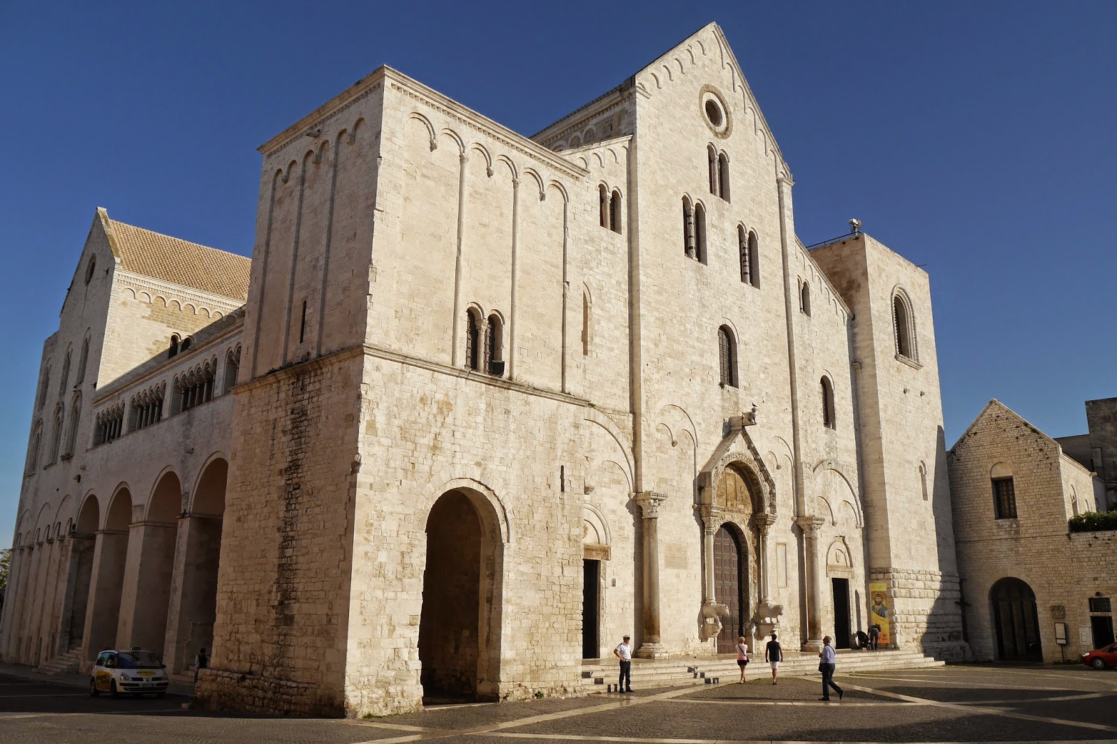
Tuesday 30 September 2014

Monopoli


 The Cathedral

We've just arrived in Monopoli, on the north coast of Puglia, which will be our base for the next few days as we explore the famous Trulli houses of Alberobello and the celebrated White Towns. We thought we should start with an exploratory walk around the town.

We are staying in a Bed & Breakfast just outside the Old Town, so we walk down the hill towards the sea and soon find our way to the Baroque 16th century cathedral. It is fronted by a small square, closed off on one side by a large stone wall. It is strange but very effective.


We walk down the street beside the Cathedral, delighted to discover that we have stumbled on the tourist historical trail around the Old Town. At the end of this street we suddenly emerge beside the old town walls and the sea. People have clearly moved off the small beach onto the rocks as the sun has left the beach, which is to the right.


Further along the street which runs behind the walls we come upon the tiny chapel of St Vito. It looks as though it had melted.


A little further on we reach the sea again and another battered church of San Salvatore.  We were struck by the shape of the windows.


Next we find the ruins of the Torre Santa Maria, from which there is a nice view of the 16th century castle.

This looks even better, basking in the evening sunshine, from directly in front.


We follow the edge of the harbour round to Piazza Garibaldi, a delightfully intimate square whose best feature is the Torre Comunale. 


We have a delightful aperitif of Fiano in one of the many bars and then walk along via Garibaldi, past another nice Baroque church, San Domenico.


At the end we briefly visit the tourist office to find out where we can locate a bank. We are very helpfully told that such a thing does not exist in the old town and pointed towards a square in the new where we can find one.

Conditions: warm, sunny, blue sky.

Distance: two miles.

Rating: three and a half stars. A charming, quiet town.

Monday 29 September 2014

Bari


Castelo Normano-Svevo

We have just arrived in Puglia for a week's holiday and we start with a walk around the old part of Bari, the capital of the region. Following our Thomas Cook guidebook, the only one I could find which deals only with Puglia, we started our walk at the Castello Normano-Svevo.

It was built by Frederic II in the 13th century and embellished in the 16th by Isabella of Aragon. It is a large, angular building, surrounded by a dry moat and rather difficult to photograph. I especially liked the Romanesque arcading midway up the walls.

After a light lunch, successfully negotiated in our best Italian, we advanced towards the Cathedral of St Sabino. We admired the beautiful white stone facade with its mixture of romanesque and baroque elements, especially the gargoyles under the blind arcading.


The cathedral dates from the 12th century and the inside was more severe than the facade, with classic romanesque round arches. 


Going round the side produced a fantastic view of the great tower.


A few narrow streets, with people sitting out having coffee or doing their ironing, brought us to the Basilica of San Nicola, apparently regarded as more important that the Cathedra. It was one of the first Norman churches in Italy, dating from 1087.


The exterior is severe, with two blocky towers either side of the nave. The effect is lightened by the sculptures of animals either side of the main portal.

Inside it is less attractive. The gilded baroque ceiling seemed merely gaudy and the three doubled columns with arches across looked like rather desperate remedial measures in the face of unsound construction.

I just loved the series of shallow blind arches on the side of the Basilica. They seemed almost art deco in feeling.


A splendid archway through old city walls, one of the old gates, showed how near the sea was.


And we quickly found a way to climb up to the broad path atop the walls to walk along towards the old harbour. This is the view back.


We headed down past the old harbour, glimpsed through a lovely line of palm trees.


Before long we reached the Piazza Mercantile which houses the town hall of 1862.


This flows into an adjacent square, at the end of which there is a great view of the rather handsome 19th century fish market on the left and the impressive Teatro Margherita on the right.It dates from 1910-12 and is apparently in the process of being restored and converted to a new life as an arts centre.


It remained only to walk along Corso Victorio Emanuele back to our hotel

Conditions: hot, sunny, blue sky.

Distance: 2 miles.

Rating: Four stars. There may not be much to see in Bari, but what there is makes an excellent afternoon stroll.

Friday 26 September 2014

Windsor and Eton

Elison House (The Windsor Almshouses)

A short, fairly local, walk today around Windsor and Eton. I noticed it in a walk book the other day and it offered me the opportunity to see the Windsor Almshouses. I parked in Victoria St, where the almshouses are, and started the walk from there.

The almshouses, now called Ellison House, were built in 1862, but I have been unable to find anything more about them. The photograph on the invaluable Images of England website (English Heritage's photo library of listed buildings) totally fails to do justice to the beautiful brickwork.

Nearby is Charriott's Place of 1863, which Images of England says formerly had a row of almshouses attached. It is an extravagant and picturesque construction.


After this, I set off towards the river for the official start of the walk, first passing in Town Hall (or Guildhall) in the High St. It was designed in 1687 by Sir Thomas Fitch and construction was supervised by Wren after Fitch's death. Next door is the delightful Crooked House.


Continuing along High St, Castle St on the right offers an impressive view of the Castle. It is remarkable just how big it is. It is of course England's largest castle and covers about 13 acres. It was founded in 1165, but most of what you see today is 19th century.


The massive walls and towers that form one side of Thames St are however from Henry III's reign (1216-1272).


I reached the footbridge across the Thames that leads to Eton and turned right following the Thames Path out of the town centre and along the edge of the Home Park enjoying more views of the castle.


You cross the river at a road bridge and double back on the other side, initially through a golf course (ugh!). There was a funny moment on emerging from the golf course when the instructions in the walk book completely failed to match what was there is front of my: specifically, there was a river where the book described rough meadowland. Walk books do become out of date of course and you expect minor changes and perhaps the odd new housing development, but a new river seemed a bit much. After a moment I realised that it was the Jubilee River, a flood defence scheme and on checking discovered that the book pre-dated the Jubilee by some years.

Thus reassured I found my way to the playing fields of Eton and then the road into the small town, where I enjoyed this view of the school and its chapel. Eton College was founded in 1440.


The school is massive, as a result of its 19th century expansion, and very reminiscent of Oxford or Cambridge. I hadn't previously realised that the chapel is contemporary with St George's Chapel in Windsor Castle and the chapel of King's College Cambridge (i.e. mid 15th century).


As you emerge from the College buildings you enter the attractive High St and I was delighted to discover, right at the end, the Christopher Hotel with its wonderful tiled art nouveau facade. The left hand section had shamefully been over painted.


Conditions: mainly cloudy with some sunshine especially at the end.

Distance: a bit over four miles from my starting point.

From: Chilterns and Thames Valley Walks (Pathfinder Guides). The full walk extends to Eton Wick and back along the river from there, 5.5 miles in total.

Map: Explorer 160 (Windsor, Weybridge and Bracknell).

Rating: four stars. There are lots of interesting things to see in Windsor and in Eton, but the walk along the river and back along the other side was extremely dull for the most part.

Tuesday 16 September 2014

Bishop's Norton and Apperley

 Bishop's Norton from Sandhurst Hill

 I met up with my friend Merv for this surprisingly rural walk not far north of Gloucester. We started at the small but pretty village of Bishop's Norton and climbed Sandhurst Hill (86m) to enjoy a panoramic view over the village to the east. The tower seems to be that of Norton Court. The view to the west was also extensive, but much too hazy to be worth a photo.

We followed the ridge along to Norton Hill and had a good view along the Severn over a hedgerow full of berries.


We descended to meet the river just by the Red Lion pub, which surprisingly has a caravan park attached. We followed the Severn Way through fields to reach Haw Bridge (1931) - the only point for many miles where the river can be crossed. This was the view back towards Norton Hill.


After an excellent lunch at the Haw Bridge Inn we continued on our grassy way, with some hills now appearing on our right.


At the next pub and caravan park combination we headed away from the river and uphill towards Apperley. It was noticeable how the mobile homes here were on stilt-like wooden frames to guard against flooding. The first thing we noticed when we reached the village was a pond complete with duck house, with the tower of the romanesque Holy Trinity church (1856) visible to the left. Had we strayed onto the property of some conservative MP?


Soon we passed Apperley Hall, a 16th century house apparently being very well restored. The gable on the left has a very worn finial which Pevsner says represents the badge of the Earl of Warwick (the bear and ragged staff). He doesn't explain why.


We headed south from Apperley to cross the Combe Hill Nature Reserve. This is named after the Combe Hill canal, long disused and now largely overgrown.


It runs from the Severn (we passed the point where it leaves earlier in the walk) to Combe Hill and was opened in 1796 and closed in 1876. It seems to have been a white elephant from the start, as it was intended to carry goods to Cheltenham, but stopped five miles short. This seems a fairly serious failure of planning.

We walked along a track to Leigh, aiming for the unusual yellow stone tower of St Catherine's church. The oldest parts of the church are 13th century.


The gravestones seemed to be blowing in the wind.


 Further field paths brought us back to Bishop's Norton.

Conditions: quite warm, but often hazy and grey.

Distance: 8 miles.

Map: Explorer 179 (Gloucester, Cheltenham and Stroud)

Rating: four stars.

Friday 12 September 2014

Ivinghoe Beacon and Aldbury

Looking south from Ivinghoe Beacon

I met up with my friend Chris for this lovely circular walk. The first part repeats the Ivinghoe Beacon to Wigginton section of the Ridgeway which I did last year: I have tried to avoid taking the same pictures again. The view above shows the Ridgeway stretching out before us.

We walked ahead, crossed a road and continued along Steps Hill to pass Instone Hole on the right.


This winding combe is a very attractive feature and this time I noticed (but only because Chris pointed it out) that there is a windmill in the middle of the large field in the background.

We headed then across open ground to cross a lane which is also the route of the Icknield Way. This is the view back to Ivinghoe Beacon.


We climbed Pitstone Hill and skirted Aldbury Nowers, a series of slopes which are now a nature reserve. Like last year, it was too late to see much in the way of butterflies.

After this we left the Ridgeway and headed east into Aldbury, first passing the church of St John the Baptist. The chancel dates back to the 13th century.


The centre of the village features the old Manor House overlooking the duck pond and stocks. We had an excellent lunch at the Greyhound pub.


We left Aldbury following a track which climbed quite steeply up to Pitstone Common and the Bridgewater Monument.


This monument to Francis Egerton, the third Duke of Bridgewater, a pioneer of the development of canals, was designed by Sir Jeffry Wyattville and erected in 1832.

The monument is within the Ashridge estate and the next stage of the walk involved following a winding track through the woods along the perimeter of the estate. Although we were quite high (200 metres or so) we could see little for the trees. Eventually we worked out that these were mostly ash trees and that we were we on a ridge - ah! Ashridge!

At length we emerged into open country and admired the open panorama to the right (slightly north of east). We were very struck by the animal carved out of the chalk of Dunstable Downs. It was the White Lion.


It is associated with the nearby Whipsnade Zoo and dates only from 1933. Only a couple of weeks ago I was looking at the much older white horse near Osmington in Dorset, created in honour of George III.


I asked myself why I didn't notice the White Lion on last year's Ridgeway walk. The picture above shows it very clearly at the end of Gallows Hill, which heads off east from Ivinghoe Beacon. I dug out last year's picture from about the same spot for comparison.


I zoomed in further today, but the Lion was definitely there last year, albeit rather less distinct. It looks as though he has been refurbished during the year.

Conditions: warm and quite sunny.

Distance: 7 miles or so.

From: Chilterns and Thames Valley (Pathfinder Guides), although we started in a different place and did the walk in the reverse direction.

Map: Explorer 181 (Chiltern Hills North).

Rating: four and a half stars.

Wednesday 10 September 2014

Zennor to St Ives (South West Coast Path 66)

 Looking west towards Gurnard's Head

One of the features of this section of the coast path is that there are no settlements at all on the coast, so you have to start from somewhere a bit inland. Today we are starting from the hamlet of Zennor, which does boast an excellent pub and a handsome church.

We walk less than a half mile to reach the coast and enjoy fine views to the west past Pendour and Veor coves towards Gurnard's Head.

Ahead lies Zennor Head, with fine rock formations behind the carpet of heather and broom.


The view west from the Head is quite inspiring. Pendeen Watch is just visible on the horizon.


Once you turn the Head, the view forward is of inaccessible sandy beaches. The terrain becomes increasingly rocky and laborious. There was however a sustained stream of people coming towards us, making this one of the busiest sections of path since Looe to Polperro, almost exactly a year ago.


The next section is a bit easier walking as we pass inland of Carn Naun Point, Pen Enys Point and Hor Point. 

As we descend towards the near sea level Clodgy Point there is a wonderful view of St Ives, with Porthmeor Beach prominent and The Island to the left. St Ives Bay can be made out in the background.


Once we reach St Ives, we start with a delightful lunch at the Porthmeor Beach Cafe and then visit the Tate. I am not really a fan of abstract art and I must confess that I found the collection rather a disappointment: it is hard to understand why some of these daubs are superior to others. The building is quite impressive though, with its dramatic peristyle entrance.


We walk around the Island and pass Porthgwidden Beach.


Then we head down to the harbour. Reaching the West Pier we are entertained by some young people unaccountably jumping into the sea.  There is a nice view across the harbour towards Smeaton's Pier.


Smeaton's Pier was built between 1667 and 1670, and was lengthened, and the new lighthouse added, in the 1890s. John Smeaton, the first man to call himself an engineer, was also the designer of the Eddystone Lighthouse which we encountered rebuilt on Plymouth Hoe.

We head inland a little to see the church of St Ia, consecrated in 1434. Its fine tower is a local landmark.


Soon afterwards we reached the fine sandy Porthminster beach before finishing our walk at the railway station. 


 There was a great view back over the harbour in the evening sunshine.


Conditions: warm and sunny.

Grading: Severe.

Distance: 6 miles (distance now covered 397.2 miles).

Map: Explorer 102 (Land's End).

Rating: four and a half stars.