Showing posts with label South Devon. Show all posts

Wednesday, 12 April 2023

Almshouses of South Devon

This post covers some impressive Almshouses in South Devon: specifically in Moretonhampstead, Newton Abbot, Wembury and Plymouth. We start with Moretonhampstead, now owned by the National Trust

'Recorded as 'new' in 1451, the building was converted into eight almshouses in 1637. Having been used as a poorhouse and private residences during the following centuries, it was given to the National Trust in 1952 and today consists of two cottages. 
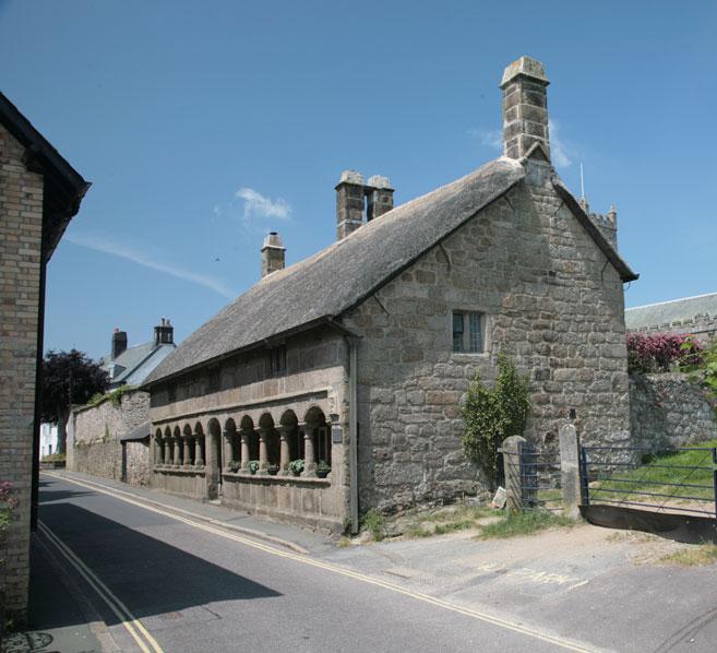
Moretonhampstead Almshouses 

Moretonhampstead 1 and 2 The Almshouses, Moretonhampstead, Dartmoor National Park


The first of the almshouses in Newton Abbot are the Mackrell's Almshouses in Wolborough Street.
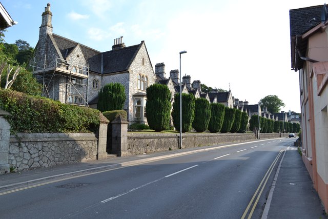
Mackrell’s Almshouses, Wolborough Street, Newton Abbot

(From https://www.geograph.org.uk/photo/4109108) The 40 almshouses were designed by JW Rowell, built in 1874 and extended in 1894.The walls are of Devonian limestone crazy-paving rubble. The slate roof is continuous with moulded rubblestone ridge stacks to party walls. The building is double-depth in plan - there are houses front and back, in similar style. The southwest (right-hand) entrance has an inscription in the tympanum which reads "By the grace of God the Mackrell alms-houses built and endowed by Thomas and Sophia Mackrell, natives of Wolborough were extended by the erection of eight additional dwellings in the year of Our Lord 1894." A similar inscription to the northeast (left-hand) entrance is dated 1874. 

Here is a more detailed view of the Almshouses:
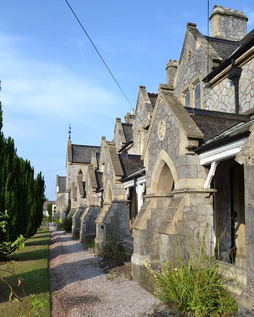
Mackrell’s Almshouses, Wolborough Street, arched entrances to houses


A group of 4 almshouses in 109-115 East Street dating from 1845 are built in a Picturesque Tudor style. Lady Lucy Reynell, wife of the owner of Forde House Torquay Road, originally endowed the almshouses in 1640. She intended them to accommodate priests widows, "the relicts of preaching ministers, left poor, without a house of their own". The original building in Torquay Road was demolished in 1790 and rebuilt in East Street nearer to the town centre. 
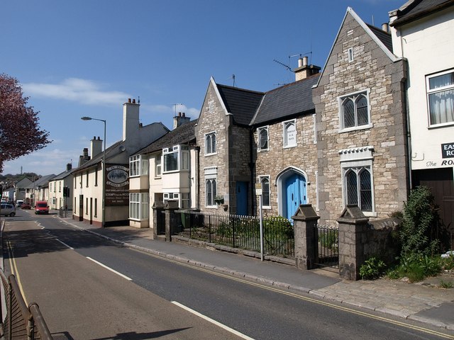
East Street, Newton Abbot


Also in East Street, at 133-147, are the Haymans Almshouses.
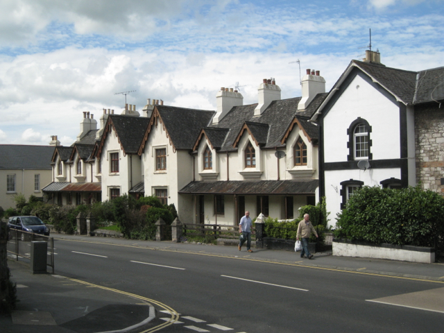
Robert Hayman's almshouses, East Street


They date originally from 1576 when Robert Hayman endowed properties in East Street "for the better maintenance and relief of poor people". These properties included almshouses. They were rebuilt in 1840 as this symmetrical terrace of eight almshouses in what Pevsners calls the Regency Gothic style.

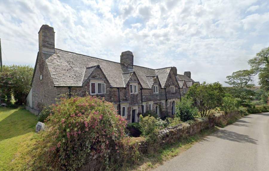
Continuing South west there are two more interesting almshouses. The first are the delightful Sir Warwick Hele's Almshouses in Wembury. They consist of 6 houses: built in 1685 and renovated in 1975. Sir Warwick was the High Sheriff of Devon at the time. Ange I walked past them almost exactly 10 years ago while we were walking the South West Cost Path.


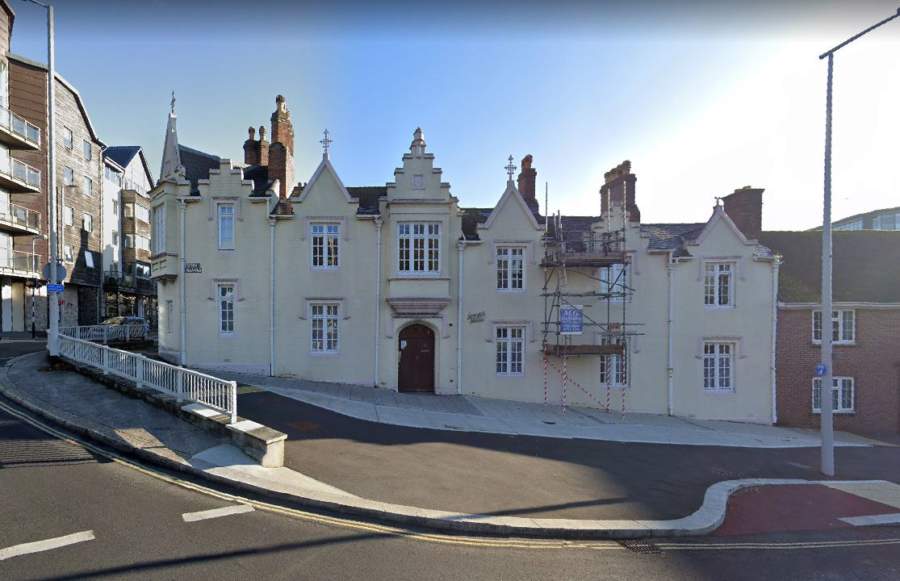
Finally, in Plymouth we reached Lanyon House in Green Street. The original almshouse was built in 1679 with £300 left in a will by John Lanyon, ex Lord Mayor of Plymouth and a Friend of Samuel Pepys. The present almshouses were moved to their site in Green Street in 1868, and renovated in 1977. They are still in use as Almshouses.
 

Finally, a mention for the Pearn Almhouse Trust in Higher Compron, which was funded by a legacy from a local benefactor, Edwin Alonzo Pearn, in 1893. The self-contained accommodation has three separate buildings.


Saturday, 6 September 2014

Topsham


We are in Topsham visiting cousins Iz and Nev en route for another bout of South West Coast Path walking. They took us for this lovely walk around their historic town.Topsham was once a the major port on the Exe estuary.

We set out from their house and walk up Monmouth Street, which has many imposing 18th century houses like those above. The Duke of Monmouth is said to have roused his troops in one of the houses along here. He led a Protestant rebellion in western England against the newly crowned James II in 1685.

 At the top we turn right along a lane, leaving the town to quickly reach the Bowling Green nature reserve. We can see lots of Small Egrets and various waders, notably Black-tailed Godwits and Greenshanks.

Further along we are tipped off by some birdwatchers that there is an Osprey roosting on the top of a post across a field. We whip out the binocs and have a good look.

The end of the lane opens out to the river estuary where the Clyst meets the Exe. We walk along a quite narrow path called Goat Walk, apparently it was only allowed to be wide enough to accommodate a man and his goat!


It leads into The Strand, with an impressive house, Strand End immediately on the right.


Just further along, we enjoyed this pretty bust.


At the far end of the Strand stands the handsome Shell House with the splendid porch which gives it its name.


Passing into Ferry Street, we climbed some steps to reach St Michael's churchyard. The views over the Exe include the wonderful Nail House with its Dutch gables.


Across the river, a wrecked boat provides a counterpoint to the smart ones moored against a pontoon. 


St Margaret's church is interesting as the sandstone tower appears to be in the angle of the transept. Pevsner (my 1952 edition) says that the church is mostly of 1869-78, although the tower is "old". I must check to see if a more recent edition is a bit more forthcoming


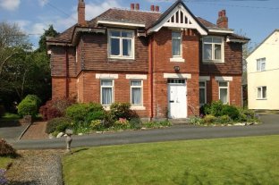
Knowing of my interest in almshouses, Iz and Nev routed us past this charming group of houses in Clara Place, in case they might add to my collection. They date from 1841, but seem to be a normal residential development on an unusual plan.


The High St has a pleasant variety of shops and buildings including the Salutation Inn of 1726. Pevsner comments on the "curious" combination of a Venetian window and a broken pediment.


Conditions: mild and bright at first, but becoming cooler and greyer.

Distance: maybe three miles.

Rating: four stars. A delight.

Sunday, 1 September 2013

The South West Coast Path - South Devon: A review

Lyme Bay

Background

It has taken us almost exactly a year to compete the South Devon section of the South West Coast: we started in August 2012 and finished in August 2013. From Lyme Regis to the River Tamar in Plymouth is, it turns out, 133 miles. We are now 219 miles in all along the Coast Path. Only 411 to go!

Because we were now farther from home we adopted a new model of making three and four day trips, in place of the previous single day outings, and this sense of increased momentum was also reflected in our efforts to walk a bit further each day, several times over 10 miles.

Impressions

Perhaps the biggest difference we noticed between Devon and Dorset is the number of river estuaries: notably the Sid, the Exe, the Teign, the Dart, the Avon, the Erme, the Yealm - and the Kingsbridge estuary (although this is strictly a ria - a drowned river valley that remains open to the sea). The Dorset section effectively has none. Planning the logistics of ferry crossings was a new challenge. Many of the estuaries were very pretty. The Erme is often especially praised, but my personal favourite was the Avon.


Secondly, although there is much isolated and unspoilt coast in Devon, there seemed to be many more towns actually on the coast than there were in Dorset - and, linked to this, a much more evident holiday industry. So there was more urbanised walking, for example around Torbay and in Plymouth. We thought Brixham (below) and Dartmouth were perhaps the prettiest. However, Torquay had some surprises: Torre Abbey and the fantastic 1912 Pavilion; while the Hoe in Plymouth is a fantastic urban open space.


But there were of course some spectacular sections of coastline. We very much liked the red sandstone cliffs around Buddleigh Salterton and Sidmouth. This is the view from Littleham Cove.


And, further west, dramatic rocky areas like Soar Mill Cove ...


... and Aymer Cove


Lyme Bay is a dominant feature of much Dorset walking and in Devon Tor Bay, Start Bay and Bigbury Bay (with Burgh Island) all loomed large. One of the great things about bays is that as you approach the final headland, you can look back at a wide sweep of coast and say that you have walked along all of it.  

One last impression is of the amount of relics of past wars, even more so than in Dorset. There are castles dating back to the fear of a Spanish invasion in the 1540s, towers built against the threat of the Dutch a century later, massive 19th century defences against the French around Plymouth and lots of traces of the Second World War, gun emplacements and the like, and also memorials like the Sherman Tank at the end of Slapton Sands at Torcross.

All in all, a wonderful section of coast!


Stages

21 Lyme Regis to Seaton

22 Seaton to Branscombe

23 Branscombe to Sidmouth

24 Sidmouth to Buddleigh Salterton

25 Buddleigh Salterton to Exmouth

26 Starcross to Teignmouth

27 Shaldon to Babbacombe

28 Babbacombe to Paignton

29 Paignton to Brixham

30 Brixham to Coleton Fishacre

31 Coleton Fishacre to Dartmouth

32 Dartmouth to Torcross

33 Torcross to East Prawle

34 East Prawle to Salcombe

35 Salcombe to Hope Cove

36 Hope Cove to River Erme

37 River Erme to Noss Mayo

38 Warren Point to Mount Batten

39 Mount Batten to Cremyll Ferry

Tuesday, 6 August 2013

Plymouth: Mount Batten to Cremyll Ferry (South West Coast Path 39)

The Citadel from Mount Batten Point

Now for the final stretch of the Coast Path in Devon. We pick up the route at Mount Batten and pause to enjoy the view across the Sound to the Citadel, with the celebrated Plymouth Hoe on the left. We walk round past the marina and climb to then get a comprehensive view across the area known as Cattewater - the estuary of the River Plym. There is a just-so story to account for the odd name: there was allegedly once a rock formation which looked rather like a cat.


As we entered Turnchapel we saw the first of many variations on the usual methods of signing: finger posts and yellow arrows on low posts, both usually having the familiar acorn symbol. The idea with this older version was presumably that the appropriate directional arrow would be painted white.


Turnchapel has the character of a fishing village, with its neat cheerfully painted houses. Most have a doorcase, although in the case of the one on the extreme left it is painted on.


Passing behind some seemingly abandoned wharves, we followed a creek round to pass a new housing development on the end of Hooe Lake.


The lake itself has an interesting mixture of industrial buildings and hulks of old ships around its edges and at the far end what looks like a small castle. We followed a mixture of urban and woodland paths around the lake, passing another novel sign post on the way ...


... and emerged at Radford Castle, looking derelict and unloved. It sits on a dam separating the tidal Hooe Lake from the freshwater Radford Lake. All I can turn up on it is that it is "an early 19th century folly".


It has to be said that the next few miles were fairly grim: boat yards, light industrial areas, a length of the A379, chemical plants, more light industry. Not like anything previously seen on this scale in two hundred miles of coast! Of course Plymouth is by far the biggest urban settlement we have passed through and the most industrialised.

Eventually, we emerged onto a hedged tarmac path in Coxside which offers a great view back across the Sound to Mount Batten.


In the ivy hedgerow, alerted by a flash of orange, we spotted a Garden Tiger moth: staggeringly beautiful.


And at the end of the path, there is the ultimate signpost-cum-waymark. We saw other less dramatic variants too: red arrows on stone and red metal finger posts high up at right-angles on lampposts.


We pass the uninspiring National Aquarium building, cross the footbridge across the mouth of Sutton Harbour and reach the busy Barbican. It is too crowded and messy to be worth photographing. We continue along the harbourside to pass beneath the massive Citadel.


This picture shows one end. It was built in 1666 by Charles II and incorporated an earlier fort of Drake's time. Charles seems to have wanted to promote Plymouth as a cross-channel port and may also have had it in mind that the town supported Parliament in the still-recent Civil War - the guns were able to fire into the town as well as out across the Sound. It would have been nice to see the baroque Portal.

There was now a great opportunity to see Plymouth's newly refurbished art deco Tinside Lido, albeit looking into the sun. It originally opened in 1935 and was closed in 1992. It reopened after massive renovation in 2005.


Now we reached the famous Hoe. The first thing that struck us was the art deco column on the far side. It is in fact a war memorial to sailors who died at sea. After the First World War an Admiralty committee recommended that the three "manning" ports in Great Britain - Chatham, Plymouth and Portsmouth - should each have an identical memorial of unmistakable naval form, an obelisk, which would also serve as a leading mark for shipping. The memorials were designed by Sir Robert Lorimer, with sculpture by Henry Poole. The Plymouth Naval Memorial was unveiled by HRH Prince George on 29 July 1924. We saw the one in Portsmouth in February 2012 without realising that it was one of a trio.


Walking back towards the sea gives a fantastic view of Smeaton's Tower. This was once the third Eddystone Lighthouse, completed in 1759 and in use until 1877 when it was found to be unstable. The upper part was dismantled and relocated here as a memorial to its designer John Smeaton. The foundations and stub of the old tower remain on the Eddystone Rocks, close to the current lighthouse.


We walked through West Hoe to reach the monumental French chateau-style Duke of Cornwall hotel, which dates from 1863.


We somehow lost our way here and headed towards the Cremyll Ferry by a route that took us past the
imposing Royal Marine Barracks at Stonehouse. It dates from 1784, but the majority is mid 19th century.


At the the end of the walk, by the ferry, was the extraordinary entrance to the Royal William Victualling Yard. It dates from 1826-35 and was the work of Sir John Rennie. The 13 foot high figure on the top of the arch is the reigning monarch, William IV. The victualling work of the Yard is symbolised by the bulls' heads and tools on the facade.


Conditions: clear, sunny and warm.

Distance: 7.5 miles. We have now completed the coast of South Devon. Next stop Cornwall!

Map: Explorer 108 (Lower Tamar Valley and Plymouth).

Rating: Four stars for the best bits, but a lot was very dreary.

Sunday, 4 August 2013

Warren Point to Mount Batten (South West Coast Path 38)

 The mouth of the Yealm

Having got to Noss Mayo last night, we resumed our walk on the other bank of the Yealm, at the edge of Wembury. I had noticed that the road down towards the sea passed some Almshouses, and as they are a special interest of mine I proposed that we should begin our walk there.

The Hele almshouses date from 1682. They consist of a terrace of six houses with a chapel in the centre, marked by the higher gable. They were founded by Sir Warwick Hele, the then High Sheriff of Devon. They make a typically picturesque group.


A bit further on we found the path down to the sea and followed a wide hedged track for half a mile or so. There were many butterflies in the hedgerow and just as we emerged to get our first view of the Yealm in sunshine, I had the opportunity to take a quick snap of this lovely Wall.


We now joined the Coast Path and headed along a level track near the top of a slope leading down to the sea. The landward side especially was covered in flowers - it was like walking through a wild garden.

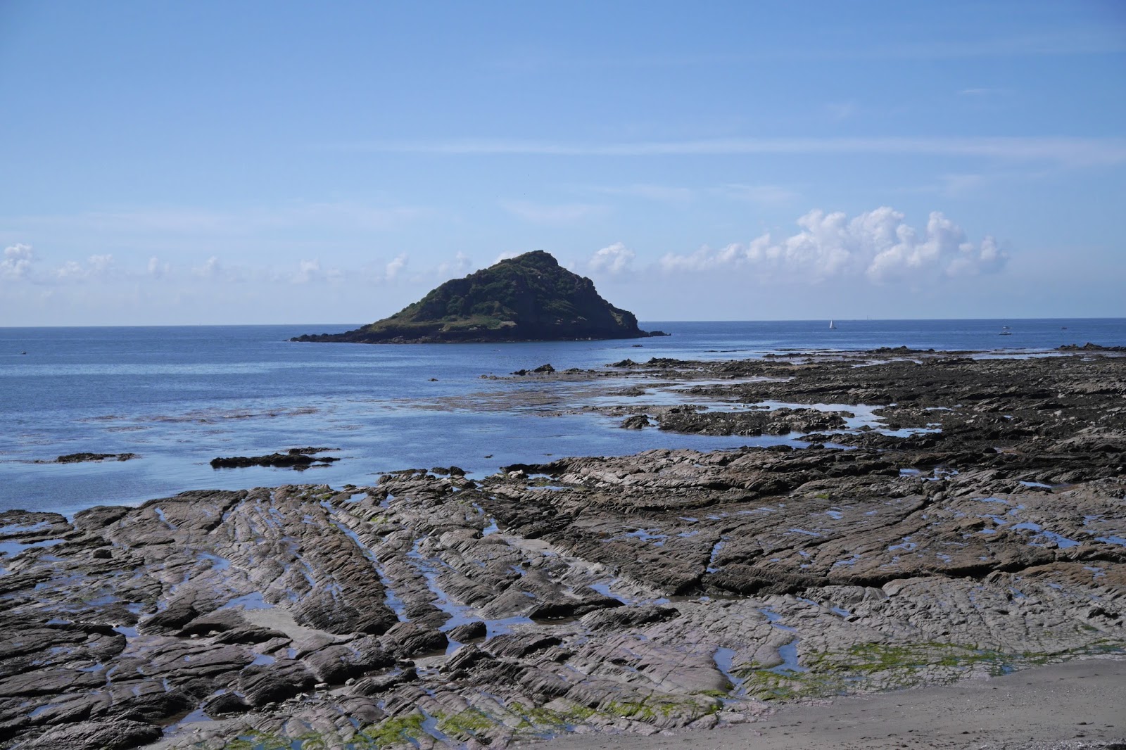
Once on the grassy headland, first viewed in the mist and rain last night, the coast stretched away invitingly. The Great Mew Stone was now on the left and Rame Head could be clearly seen in the distance beyond.


We soon reached Wembury, passing the church of St Werburgh in its remarkable location so close to the sea. The handsome tower dates from the 15th century, although it and the whole south side of the church have been pebble-dashed, presumably to protect the stone underneath from the elements.


The path then goes round the back of the attractive beach, where any amount of rock pools demand exploration. The rocks extend out in increasingly flat shelves towards the Great Mew Stone.


The next milestone is Heybrook Bay, where we resisted a detour to that rare thing, a pub close to the Coast Path. As we turned the corner, a new vista opened up across Plymouth Sound.


At first we couldn't quite work out what we were seeing in the centre of the Sound, having stupidly left the relevant map behind. We subsequently established that the mystery element was the Plymouth Breakwater, curved in shape with a fort standing just behind it. There is a lighthouse at one end and a beacon at the other. Directly behind, on the far side of the Sound, is Picklecombe Fort.


The breakwater was constructed in 1812 as a safe harbour for the English fleet during the Napoleonic wars. The Breakwater Fort dates from 1860 and was thus almost contemporary with the Palmerston Forts near Portsmouth which I passed on the last leg of the Wayfarers Walk.

The path climbed and soon offered a view of Drake's (or St Nicholas's as it says on the OS map) Island. Drake set out from here in 1577 to circumnavigate the world, returning in 1780. In 1583 he was made governor of the island which later fortified against possible Spanish attack. In the 16th century it was used as a prison and bigger guns were installed as part of the 19th century defences of the harbour.


We now passed the holiday centre at Crownhill Bay and the popular beach at next door Bovisand, climbed up behind Bovisand Fort and walked through a wooded area from which we had a clear view of Mount Batten - the small hill on the left with a fort on top.


The large grassy area in the photo is called Jennycliff and having walked along there - a delightful open area so near to the city - we somehow missed our route and walked beneath Fort Staddon, seen here from further down the hill.


This strange building, spectacularly ugly and not especially fort-like, is improbably now a leisure centre and country club. It dates from 1869 and was originally a gun battery.

Soon after this we reached Mount Batten, as already noted a bit of a misnomer. Its tower dates from about 1650 (this time the fear was war with the Dutch) and was still housing guns 70 years later. In the 19th century it was a lookout post.


Conditions: clear, sunny and warm

Distance: again somewhat over 9 miles, of which 8.5 were on the coast path. Just one more leg to do and we will have completed the coast of South Devon.

Map: OL 20 South Devon.

Rating: Four stars.

Butterflies

This was a very good day for butterflies: we saw 16 different species, more than a quarter of the UK total. Red Admiral, Peacock, Painted Lady, Small Tortoiseshell, Comma, Large White, Small White, Green Veined White, Common Blue, Holly Blue, Small Skipper, Meadow Brown, Gatekeeper, Speckled Wood, Small Copper, Wall.