Thursday 3 December 2020

Newbury

                                                             St Bartholomew's Hospital

It is almost three years since we moved to Newbury and I thought it would be a nice idea to post a blog about the town. I started my route at St Bartholomew's Hospital, founded in the early 13th century possibly by King John. A number of other almshouses can be found in Argyle Street and elsewhere in the town.

From the top end of Argyle St I went up Newtown Road to admire these grand Italianate mansions of circa 1869-70. Pevsner suggests that this was a stalled villa development.


Now along Portchester Road to head towards Newbury Racecourse where you are greeted by this unusual and mysterious sculpture.


Horse racing first took place here in 1905, although other locations in the area had been used for a hundred years before.

I retraced my steps to cross the railway and head towards the town centre along Cheap Street. On the right was the former Public Library, latterly a Prezzo restaurant and now empty like the Post Office further along the road. The building has the distinction of having been funded by the philanthropist Andrew Carnegie.

Just before reaching the Market Place I felt I had to photograph Newbury's tallest and most ugly building, the BT tower, or the Stasi building as I prefer to think of it. It dominates many a view of the town.

On the right in the Market Place are the delightful Elephant pub and the former Corn Exchange of 1862, now an arts centre.

If you turn right at the far end of the Market Place into Wharf Street you find the recently restored Granary building, now part of Newbury museum. It dates from about 1723 according to Pevsner.

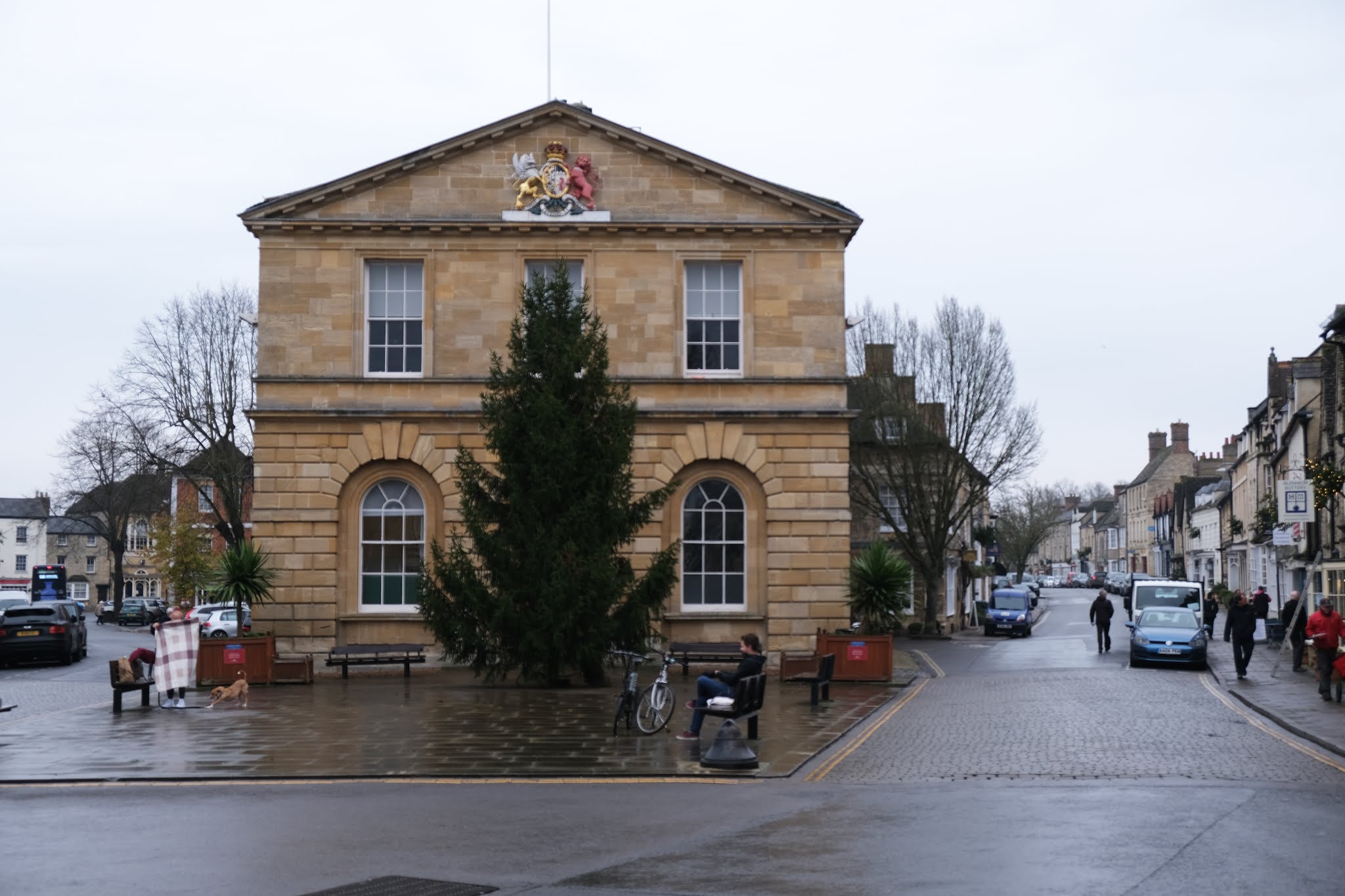
Retracing your steps you are confronted by the Town Hall on the opposite corner. It was built by a local architect, James H Money, in 1876-81 rather in the style of Alfred Waterhouse. An extension was added in 1909-10, also by Money. What did he do in between?

Just beyond the extension, in Bartholomew Street is St Nicholas church, rebuilt c 1509-32. Pevsner judges it to be more like a Cotswold wool church than a typical Berkshire one. Access to the church is via either of two fine Gothic style archways which date from 1770.

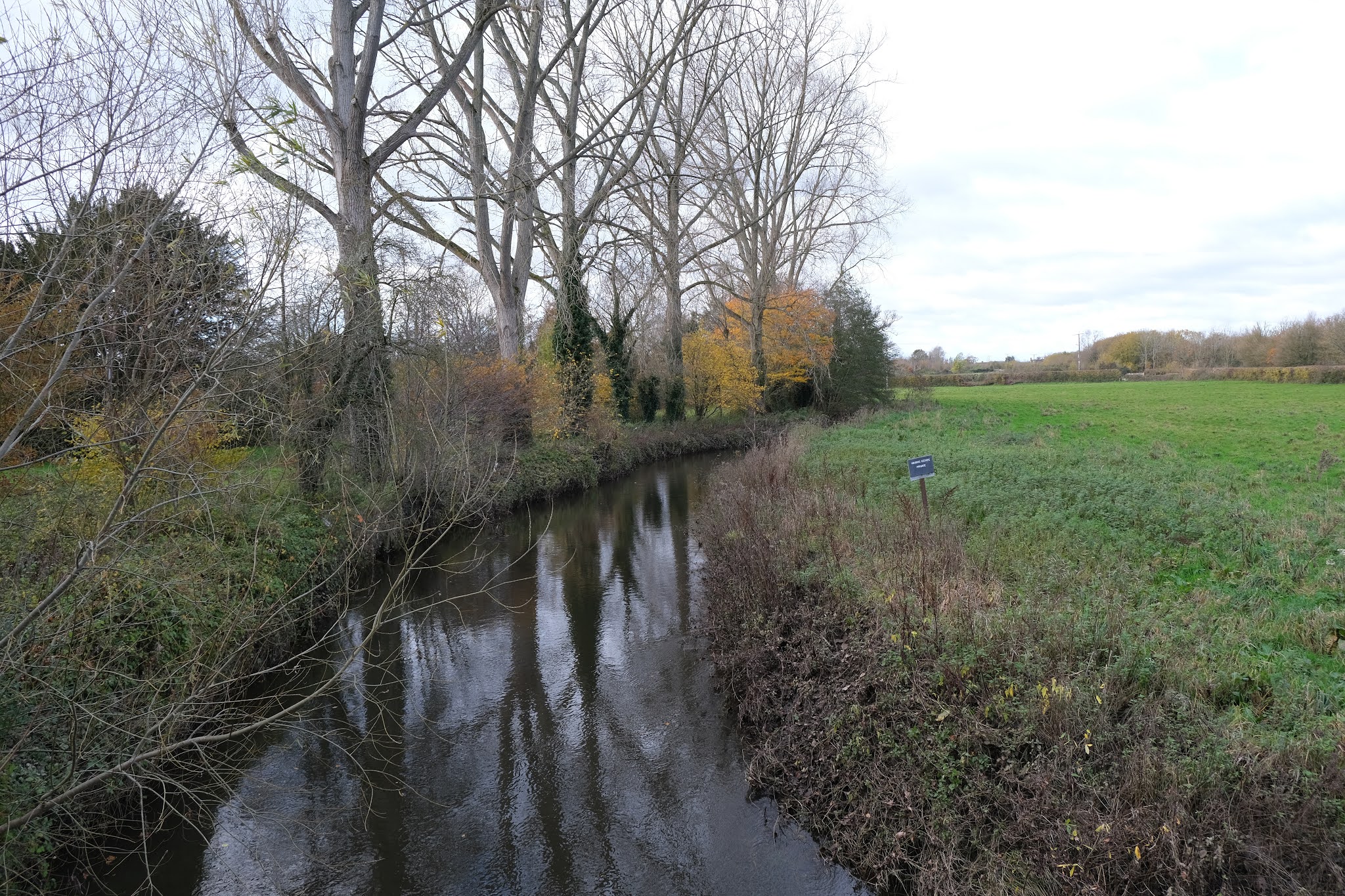
I continued along Bartholomew Street to cross Newbury Bridge (1769-72) over the Kennet and Avon canal ...

... and then turn sharp right to descend to the canal bank. The remains of a wharf can be seen on the far side of the canal.

Now into Victoria Park, past the tennis courts to reach the Queen Victoria memorial. The statue and attendant lions was funded by George Sanger (1825-1911), a Newbury born circus owner (is that a clue to the presence of the lions?), and designed by Arthur E. Pearce. It was originally located in the Market Place but removed in 1933 and put into storage. It was installed in its present site in 1966.

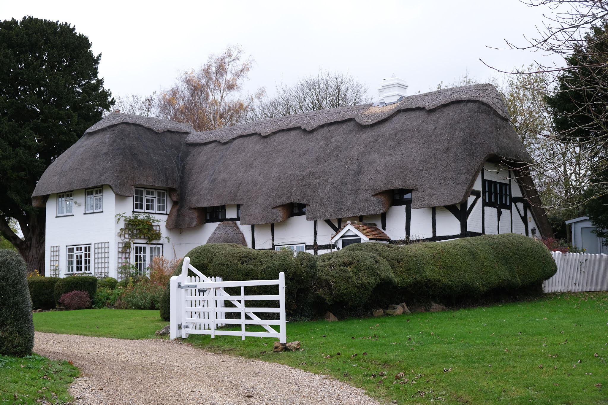
Heading west now I passed this very attractive terrace and emerged into Parkway,


Then into London Road, once the main road from London to Bath. There are a few imposing Georgian houses along here.

Then left into Northbrook Street at the Clock Tower of 1929 ("Tower" seems an overstatement) and along the wide, mostly pedestrianised street with many 18th and 19th century buildings, now all shops, many of which are vacant.

 On the right is the slim and elegant Methodist church of 1837-8.

Retracing my steps over the Bridge and along Bartholomew St I turned right into Craven Road to pass the one time Oddfellows Hall of 1886, now apartments. I have found it quite difficult to pin down just what the Oddfellows now do - their website is curiously opaque. There is certainly a Friendly Society ...


I ended my walk there and headed home.

Conditions: grey at first becoming brighter.

Distance:  Perhaps four miles in all.

Monday 30 November 2020

Blenheim Palace and Woodstock


The Great Court of the Palace

A birthday outing to Blenheim on rather a grey and misty day. The first thing to know about Blenheim is that it was built as a national monument rather than just a home. Queen Anne provide the land and money to build the palace to commemorate the defeat of Louis IV's army at Blenheim on the Danube in 1704. It was seen as a great victory and the first real check on Louis's attempt to dominate Europe. The architect was Sir John Vanbrugh.

We parked up and headed towards the Palace, soon arriving at the Kitchen Court, which sits on the west side of the Great Court. The gateway is certainly impressive and Pevsner describes it as having a rugged military character. Although the gate was half open it wasn't possible to explore the courtyards or the interior.

We turned right passing the large lake, the work of Capability Brown in 1764-74, who swept away Vanbrugh and Henry Wise's design for the grounds.


Having reach the Great Court we headed away from it ...

... crossing Vanbrugh's magnificent Palladian style bridge, which separate the two parts of the lake.
 

 Having crossed the bridge there is a view of the Column of Victory (1727-30).

Returning across the bridge, we found an interesting poster which showed Vanbrugh's beautiful original design for the bridge.

Heading towards the Palace we turned right to skirt the Stable Court and visit the formal gardens - which were a little disappointing.

We retraced our steps towards the car park and then turned left towards the gate which leads to Woodstock. This brought us a much more dramatic view of the bridge.


We went through the Italianate gateway into the main street of Woodstock ...

 ... and followed the road round to the right to pass the church of St Mary Magdalene, a medieval church almost completely rebuilt by A W Blomfield in 1878.

 A little further on is the the Bear Hotel ...

 ... and the Town Hall. The lower storey probably served as a market hall until it was enclosed in 1898.


We then did a loop around the main streets of the town and then returned via the Gate to the car park. Woodstock is a consistently Georgian town. It is a pleasant town,  although with no individual building being especially remarkable.

 Conditions: cold and grey.

Rating: five stars

Thursday 19 November 2020

Wasing, Brimpton and Ashford Hill

                                                         Wasing Place

Another walk with my friend Merv under the dispensation for meeting a friend for the purpose of walking. We met up at Brimpton Common opposite the former Pineapple Pub, now an Italian restaurant, and headed northwards across a wet and muddy track. We then followed a track skirting Wasing Wood to reach Wasing Place. The house was largely rebuilt after the Second World War, re-creating the original Adam style building of 1773.

To the left of the house is St Nicholas's Church dating from the 13th century, but largely rebuilt in 1771.

 Further off to the left is an interesting miscellany of buildings, which may be part of the holiday lets offered by the Estate.


We had a very pleasant walk through the estate and left it to cross Shalford Bridge over the mighty Enborne, here fairly straight and calm.


Now we followed field paths to reach Brimpton and the gateway to St Peter's Almshouses (which date from 1854 but presumably are no longer in use as such).


We headed round the corner to reach St Peter's church of 1870. For the first time the sun came out.


We crossed a large field to reach Hyde End and pass Hyde End House and and then Hyde End Farmhouse. We passed an interesting house which was apparently once a trout farm ...

... and then walked along beside the River Enborne again for a short way before climbing through woodland, now briefly in Hampshire, to cross some very wet and muddy terrain and eventually emerge at the Ship Inn in Ashford Hill.

We now headed through the delightful - but also wet - Ashford Hill meadows, then climbed steadily through woodland and then across a large open area to return to Brimpton Common.

Conditions: Cool, often wet under foot.

From: Walks in the Kennet Valley and beyond (West Berkshire Ramblers).

Distance: 6.5 miles.

Map: Explorer 159 (Reading, Wokingham & Pangbourne).

Rating: four stars.

Wednesday 11 November 2020

Peasemore, Chaddleworth and Hill Green


Another walk with my good friend Merv, who planned the route.

We met up on the edge of Peasemore, north of Newbury, and without seeing anything much of the village headed off to the west. We followed a road, passed a nice looking pub, and then took a path to reach attractive open country.

We crossed the B4494 and followed a road to reach Cotswold Farm and a grassy track took us to Oak Ash Farm. From here we skirted Chaddleworth to head east again along a lovely green track marked on the map as Wick Lane. We turned briefly onto a road and then across a sequence of large fields to reach the  attractive Manor Farm on the edge of Leckhampton. We continued past the farm to reach the main street and this church which has been under restoration for many months. The latter section duplicated part of the Chaddleworth and Leckhampton Ange and I did in March.

We continued along the same line to descend to cross the B4494 again and then climb to reach the fascinating hamlet of Hillgreen. Immediately in our left was The Old Manor, a beautiful half timbered house.


 A short way further along was this splendid Georgian mansion, Hill Green House.

We turned right a few more cottages and headed up a field, which was surprisingly covered in a crop of Oilseed Rape. I seem to have seen much less rape than usual this year and it seems very odd to see it in November.


At the top we emerged through some trees to find a beacon in a large grassy field. 

Now along a short section of road, past a wrecked SUV which had driven into a tree, to cross a field and reach Peasemore. The path took us through the front garden of a house - the owners were enormously friendly and unfazed - to reach the church of St Barnabas.

The tower bears the inscription "1737 Will Coward Gent built ye tower" (Pevsner) but what you see now is largely the result of a remodelling in 1842 and the addition of a new longer chancel by G E Street in 1865.

As we returned to our cars we passed this lovely group of barns belonging to Peasemore Manor.


Conditions: cloudy, grey.

Distance: 6.5 miles.

Map: Explorer 158 (Newbury & Hungerford).

Rating: Four stars. Thoroughly enjoyable.

Sunday 18 October 2020

Golden Cap


                                                            Golden Cap

Golden Cap is famously the highest point on the south coast at 627ft / 191m above sea level. The name derives from the distinctive outcropping of golden greensand rock at the top of the cliff. We crossed Golden Cap on a 6.5 mile South West Coast Path walk from Eype to Charmouth in 2012. It seemed about time to see it again. We started this time from Seatown, accessed via a narrow road down from Chideock.

We parked at the busy car park, owned by the Anchor Inn nearby, and headed back up the narrow lane to soon turn left following a sign to the Coast Path and Golden Gap. This led first through woodland and then to more open land. We soon realised one feature of this walk: it was very popular.

Looking back, we could see Thorncombe Beacon, with the Isle of Portland in the distance.


Golden Cap became more striking as we got closer (see photo at the head of this post). And naturally the higher we got, the more extensive was the sweep of coastline that could be seen behind us.

We passed the simple memorial to the Earl of Antrim, who, as Chairman in the 1960s and 70s, spearheaded the National Trust's drive to buy up sections of the coastline before developers moved in. 

There were great views to the west ..


We were very struck by the patchwork quilt of small green fields inland - astonishingly different from the vast arable fields of Wiltshire where we have also walked a lot lately.

Our route now took us downhill to reach the ruins of St Gabriel's church a few hundred yards inland. It apparently dates back to 1240. 

This is all that remains of the lost village of Stanton St Gabriel. I have read that the main road was moved a mile and a half inland at some point, because of coastal erosion, and that this was the cause of the village's demise.

We now headed inland along a narrow lane to reach a crossroads. We turned right and continued up Muddyford Lane, which after a while became extremely steep. We turned right onto a concrete track and passed a National Trust farm with the great bulk of Langdon Hill (178m) on our left. After a couple of fields and large grassy area we found Pettycrate Lane (a muddy track) which headed all the way downhill to meet the Chideock to Seatown road, running more or less parallel with the route we came up on. It was very quiet, although we still crossed a few walkers coming up the hill. Turning right at the bottom we soon returned to the car park.

Conditions: cool and cloudy.

Distance: 4 miles.

From: 50 walks in Dorset (AA).

Map:  Explorer 116 (Lyme Regis & Bridport).

Rating: four stars.