Showing posts with label Essex. Show all posts

Tuesday, 15 March 2016

Chelmsford

 Shire Hall

On the way back from a trip to Suffolk, there was just time for a short walk around Chelmsford, a city only since 2012, when it was awarded the status on the occasion of the Queen's Jubilee. I started at Shire Hall in Tindal Square at the top of the High St. It dates from 1790-2 and was designed by John Johnson. It is, said Pevsner, "a thoroughly civilised public building". The facade is very harmonious and well-composed.

Just behind Shire Hall lies Chelmsford's other main architectural treasure, the Cathedral of St Mary.


It is all too obvious that this is a parish church later elevated to cathedral status, in this case in 1913. The tower is the oldest part, dating from the 15th century, and there were significant additions and alterations in late Victorian times and in 1923.

Inside the cathedral is light and surprisingly colourful, with a wonderful Tudor style ceiling in the nave dating from 1899. The late 15th century piers were rebuilt by John Johnson, mentioned above, in 1801-3.


The church is surrounded by an irregularly sized church yard, with Victorian or late-Georgian houses on the New St side.


I headed up New St and crossed the inner ring road to reach the offices of the former Marconi works of 1912, once one of Chelmsford's principal employers. The whole site is now being redeveloped as apartments, having I think been empty for some long while.


I turned back towards the centre and then right into Victoria Road and on into Victoria Road South, where I found this imposing 1908 building, also recently done up. It was apparently the Law Building of the former Anglia Ruskin University central campus.


Back up Victoria Road South and into Duke St, to find the red brick County Hall of 1909. Clearly the years before the First World War were an important time for Chelmsford. Surprisingly it is not even mentioned in Pevsner.


It is in any event dwarfed by the newer stone County Hall next door, dating from 1935. It seems the earlier effort was soon found to be inadequate. This is in Pevsner, and he is scathing about it: "a sad anticlimax ... classical motifs handled loosely and without distinction ... it might be a bank in any city bigger than Chelmsford".


It is indeed curiously unimposing, but a closer look reveals that quite a lot of effort has gone in to the decoration of the facade.


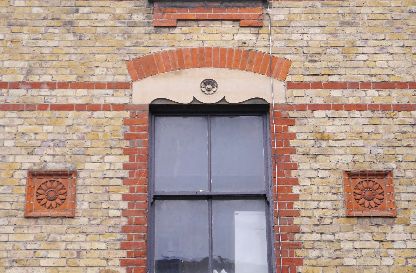
Further along the street I enjoyed these nice sunflower panels on the first floor of a Victorian shop.


Duke Street leads back into Tindal Square where the 18th century Saracen's Head stands, surely a one-time coaching inn.


Conditions: grey.

Distance: about a mile and half.

Rating: three stars. My researches hasn't led me to expect much, and I wasn't wrong. I may have missed some other worthwhile buildings, but most in the central area are modern. In truth it doesn't really feel like a city and interestingly the road signs in from the A12 still refer to "town centre".

Friday, 13 February 2015

Dedham to Flatford Mill

High Street, Dedham

Pevsner describes Dedham as "easily the most attractive small town in Essex" and as we arrive here with our friends Dave and Chris we are inclined to agree. We parked near Dedham Mill and walked up to the High Street to see the church of St Mary the Virgin.


This is a typical wool church, started in 1492 in the Perpendicular gothic style.

A little further up the High Street is the former Grammar School in pair of early Georgian houses. John Constable apparently went to school here.


We walked further along, and continued into Brook Street then Crown St to see two sets of almshouses. Barfield's Almshouses date from 1834.


Dunton's Almshouses, further up the road, date from the 16th century but were rebuilt in 1806 and modernised in 1966. They are less visually interesting.

We retraced our steps and headed across the fields towards the River Stour.


This was slightly confusing as we have only recently completed the Stour Valley Path in Dorset. After walking across the water meadows we reached a bridge across the river with the National Trust tea shop known as Bridge Cottage on the far bank. A family of swans enlivened the foreground.


After crossing the river into Suffolk, we turned right passing the exquisite Valley Farm on our left ...


... to reach Flatford Mill, where Constable painted the celebrated Haywain.


Nearby is Willy Lott's House, the subject of another of Constable's pictures.


We now retraced our steps and walked up the hill away from the river and along a path by the road to reach East Bergholt. Pevsner describes St Mary's church as "eminently picturesque" with its incomplete tower and brick west end.


The church was begun in the 15th century and the tower in 1525. It seems that construction soon stopped, never to be resumed. The church bells were placed in an unusual structure in the churchyard called a Bell Cage and are still rung from there.


From here, we walked back a little way along the road and turned right to walk down a track towards the river and return to Dedham across the water meadows, finally reaching the bridge and mill.

Conditions: cold with a threat of rain.

Distance: just over 4 miles.

Map: Explorer 196 (Sudbury, Hadleigh and Dedham Vale).

Rating: four stars. Full of interest.

Thursday, 12 February 2015

Coggeshall

West Street, Coggeshall

We are in Essex on a visit to our friends Dave and Chris and they have taken us to see Coggeshall, near to where they live. We park in the centre and head off along West Street.

West Street has a nice mixture of Georgian houses with older half-timbered ones. After a short while we come to Paycockes House, a simply fabulous half-timbered house built for merchant Thomas Paycocke in about 1500. Pevsner describes it as "one of the most attractive half-timbered houses in England". It is owned by the National Trust, but was not open today.


The detailed wood carving is especially impressive.


We retraced our steps to Market Hill and walked up Stoneham St to be immediately confronted by wonderful wooden Clock Tower. It dates from 1887, i.e. Queen Victoria's Golden Jubilee.


Further along the street on the right is this whitewashed half-timbered house' It struck us as rather unusual - typically the wooden frame is brown or black. On the right hand side, near the ground, can be seen a plaster sheep. This is a reminder that wool was the original source of the town's prosperity.


We turned right into Queen street, passing another plaster sheep and then this vivid depiction of  a gun-dog.


At the end, just before the church and much to my delight was a set of almshouses. The blue plaque revealed that they were founded with money given by Josiah Greenwood in 1795. They were built (or rebuilt) in 1864 and renovated in 1981.


The fine church of St Peter-ad-Vincula (St Peter in Chains - apparently there are other churches with this dedication) lies just beyond the almshouses. It was built to a single plan in the 15th century and is 125 feet long. The tower was rebuilt after being damaged in the second world war, and we all felt was too low for the rest of the building. It was still in ruins, along with the nave, when Pevsner visited in 1953.


When we visited a wake was in progress, but we were still welcomed to have a look at the inside - and indeed offered cake - which was very generous.

We walked down Church Green, where I failed to spot four almshouse bungalows of 1900. This led into Church St, where we admired the unconventional, but very successful, colour scheme of this Georgian house. We also wondered about the little glass room which can just be seen at the top. Is there a name for such a room?


Conditions: Cold and pretty grey.

Distance: a couple of miles.

Rating: four stars. A little gem.


Postscript

On the way home, we stopped to admire Coggeshall's other National Trust property: Grange Barn. This vast monastic barn dates from the 13th century and is "one of Europe's oldest timber-framed buildings" according to the National Trust.


Wednesday, 10 April 2013

Colchester

Colchester Castle

About the walk

En route for another meeting in Harwich. Last time I had an excellent walk around Harwich itself, today I am breaking my journey to walk around Colchester, self-styled as the oldest recorded town in the country. In 2022 the town became a City as part of the Queen's Platinum Jubilee honours.

I hop off the mainline train at Colchester and get a shuttle train round to Colchester Town station where the walk, which I scanned from Walk magazine in Autumn 2008 (you never know when these things will come in handy), commences. You turn right and right again, skirt the early Victorian St Botolph's (in a presumably sympathetic romanesque style) church and find the ruins of St Botolph's Abbey.


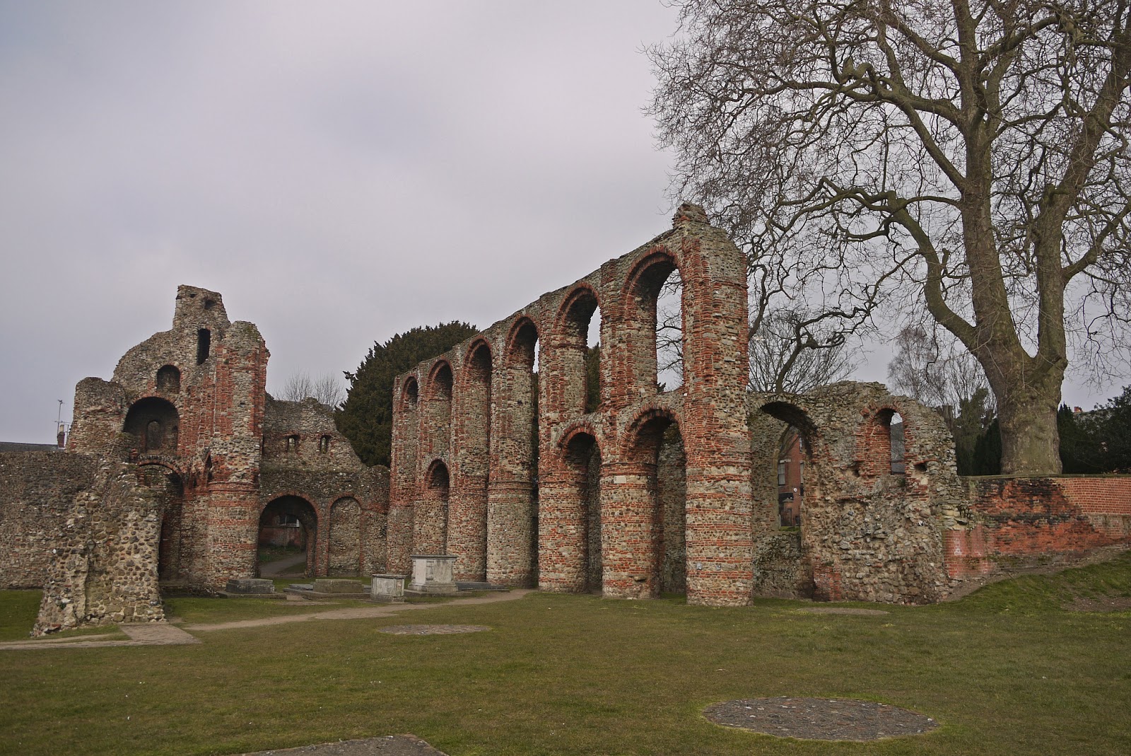
This was an early Norman church of considerable size. Above is the view from the east end back along the nave. And this is the west front.


It was built with a mixture of flint and Roman bricks. Usually one would look to the Dissolution of the Monasteries to explain the ruinous state of an Priory, but this was badly damaged by cannon fire during the Civil War siege of 1648.

I followed Priory St, with sections of Roman wall on the left, to reach East Hill. here I took the optional detour to the right to cross the river Colne and see the Siege House, now a restaurant. the corner has civil war bullet holes helpfully marked in red. Although much restored, Pevsner dates the house to about 1500.


I retraced my steps and walked up East Hill to see on the right, opposite the Minories - an art gallery in a red brick late 18th century house, a nice pair of old houses. The Gate House on the left is described by Pevsner as as "excellent house of c1600". I confess to a childish delight when I spot something not mentioned in a walk description, but praised by Pevo.


Behind the Minories is firstsite:newsite (ouch!) the town's new arts centre, designed by the New York- based architecture practice, Rafael Vinoly. Its website seems to limit the name to firstsite. Locals apparently call it the Banana, no doubt on account of the curve, which is not apparent in the photo.


I retraced my steps and cross East Hill to pass Hollytrees, Colchester's "best C18 house" (Pevsner again) and enter the Castle Park. The Norman keep is immediately ahead, looking at first more like some vast church. And in fact the projection on the right is the apse of a chapel.


It is late 11th century and is the largest Norman keep in existence, measuring 152 by 100 ft, bigger than the White Tower of the Tower of London. It would originally have been faced with stone, what you see now is the rubble and brick core. The castle was used a gaol in the 17th century  and in the  1740s it was owned by Charles Gray, the local MP, who restored parts of the building and added the cupola, also creating the park around it.

I left the park and found my way into Maidenburgh St in the so-called Dutch Quarter: Protestant weavers from Flanders settled her in the 16th century in attractive timber framed houses. The first memorable sight however was the Greek Orthodox chapel of St Helen (or Helena). 


I was warmly invited in by the priest (the not very Greek-sounding Father Haig). He explained that the structure is one of the oldest buildings in Colchester and was built as a chapel in Saxon times. Suppressed during the Reformation, it had a variety of secular uses before being restored by the great Victorian architect William Butterfield in the 1880s, to become a meeting hall for the C of E, and later a store room. In 2000 it was leased to become the church of the Orthodox parish. (All this, and more, from the parish website.) Colchester it turns out has one of the  largest Greek communities in Britain.

The timber-framed houses of the Dutch weavers have almost all been re-fronted, but these two made a picturesque pair.


Now round to West Stockwell St, which Pevsner thought was "perhaps the most attractive street in Colchester". This handsome late 15th century wool merchant's house, now a solicitors, is the highlight.

You emerge into the High St pretty much underneath the massive 162 ft high tower of the Town Hall, a landmark for miles around. It sated from 1898-1902 and was designed by Sir John Belcher. The bronze figure at the very top of the tower is that of St Helena, the patron saint of the town.


At the top of the High St I noted another interesting structure, the colonnaded Essex and Suffolk Fire Office, built as the Corn Exchange in 1802, according to Pevsner. Here you turn right, and the left opposite the 18th century St Peter's church, with its imposing tower.


A short passage brings you to an even more imposing red brick structure: "Jumbo", the 105 ft high water tower built in 1882 - the other great feature of Colchester's skyline. Pevsner describes it as "painfully assertive, but age had brought it a certain grandeur.


Just behind Jumbo, you go right back in time to the original Roman gate, the Balkerne Gate, which once had four openings.


Turning left you follow a quite well preserved section of the Roman walls.


Then you turn left and go through a church yard to reach Sir Isaac's Walk and pedestrianised Eld Lane with its specialist shops to reach Vineyard Steps. The walk instructions say you should "look ahead" to see the gatehouse of St John's Abbey. In fact it is invisible from here and stands a few hundred yards away across a duel carriageway. However it is worth the struggle to get there to see the 15th gatehouse, all that remains of a Benedictine Abbey, dating from the late 11th century. The photo unfortunately could only be taken into the sun.


From here it is short walk back to Colchester Town station, from where I continued my journey to Harwich.

Conditions: mild and mostly bright.

Distance: perhaps 3 miles, about an hour and half.

Rating: four stars. Very interesting. Some lovely buildings from a wide range of historical periods.

Tuesday, 12 February 2013

Harwich

The Guildhall

I was in Harwich on business and naturally planned to have a town walk after I had finished my meeting. I found a partial tour on the Harwich Society website and putting this together with other information and a sketch map on the same website I was able to develop my own route around this interesting port. I have since found an extraordinarily well-documented walk around Harwich on the Discovering Britain web site. This is rune by the Royal Geographical Society and looks to be an absolute treasure trove.

I started the walk at the railway station and turned away from the town to find the Redoubt. This is a circular fort surrounded by a deep moat which was built in 1808-10 as a defence against invasion by Napoleon. It originally accommodated ten 24 pounder cannon. The guns were later upgraded several times, but it never fired a shot in anger. In World War II it was used as a detention centre for soldiers awaiting court martial. In winter it is only open on Sunday, so I had to content myself with a walk around the outer perimeter.


I then doubled back towards the town and turned right towards the sea to see the Low Lighthouse, now the maritime museum.


Behind it, across the green, is - yes! - the High Lighthouse.  A helpful plaque reveals that they both date from 1818 and were designed to work together as leading lights to guide ships into the harbour. However, as Languard Point silted up and the safest route changed they became known as "misleading lights" and their use was discontinued in 1863. (In case you were wondering where the light is, the picture was taken from the land side, so the fixed glass for the light cannot be seen.)


Nearby is the celebrated Treadwheel Crane. It is believed to be the only remaining example of this type of crane in the country. Inside the hut are two caged wheels in which men walked to lift and lower the crane. There was no braking mechanism so it must have been a very hazardous undertaking. The Crane dates from 1667 and was moved from the naval yard to its present site in about 1932. This of course explains the element of mystery in its present location: what is a crane doing on a promenade behind a beach?


There was a nice group of late Georgian houses on the nearby quayside ...


... and I then turned into Church Street. Immediately on the is left Forresters. Dating from 1450, it is thought to be the oldest house in the town.


I passed the barn-like St Nicholas church of 1822 on the right. It could apparently seat 1500 people. A little further up the street I reached the imposing Guildhall of 1769, looking like a substantial merchant's house, now the home of the Town Council.

Further along Church Street is the modest house of Christopher Jones, master of the Mayflower, no doubt the most famous Harwich ship. I turned left into West St to check out the Old Customs Houses, a pair of undistinguished red brick houses. From here it was a few steps to the Quay. I waited to cross while a convoy of identical Land Rovers without number plates drove by, presumably fresh off a ship.

The view from the quay was dominated by the line of modern cranes which mark the port of Felixstowe.


To the right there is the Halfpenny Pier. It was opened in 1853 as the Corporation Pier and acquired its current name from the original entry fee.


Opposite is the extravagant former Great Eastern Hotel and the jolly Pier Hotel, now a restaurant. I turned right along King's Quay to pass a fine Georgian building which I think is the Old School House.


A little further on is the wonderful Electric Palace cinema - it was built in 1911 and is said to be the oldest unaltered, purpose-built cinema in the country. We did a walk in Notting Hill last December where we saw the Electric Cinema, also of 1911, which our guide book claimed as the oldest purpose-built cinema - but no doubt it has been altered.


It was shut, but looking through the railings it was possible to see this heading above the left hand door. The door on the right offered admission at six pence.


From here it was a short walk back to the station.

Conditions: cloudy, very cold wind.

Distance: about 2 miles

Rating: four stars - full of interest.