Wednesday, 30 May 2012

Abbotsbury

Abbotsbury Sub-Tropical Garden

We walked through Abbotsbury in January on our Langton Herring to West Bexington leg of the South West Coast Path. We always meant to come back and see it properly - and today was the day.

Abbotsbury was the site of Benedictine Abbey founded in the 11th century. After the Dissolution of the monasteries the land and buildings came into the possession of Giles Strangways and is still owned by his descendants.

We started from the Sub-Tropical Garden founded by the first Countess of Ilchester (the family name of the Earls of Ilchester is Fox-Strangways) in 1765 as the kitchen garden of the now-demolished Abbotsbury Castle and embellished by later Earls.

We walked through the beautiful gardens and reached a newish viewpoint overlooking the Fleet, with Portland very clear in the background.


The next section allowed a lovely glimpse of St Catherine's Chapel in a gap between the trees, with gorgeous azalias in the foreground.


Having completed our circuit of the gardens, which really were excellent, we walked down the road towards Chesil Beach and followed the Coast Path in the reverse direction to last time to reach the track which leads down to the Swannery. This time we went to explore.

The Swannery is an artificial pond which dates back to at least 1393. The swans were originally reared as a source of food for the monastery. Nowadays it is the only managed colony of nesting mute swans in the world. We were lucky that it was the nesting season - although we were dismayed by the signs we saw in all directions calling people to come and see the "baby swans" - cygnets surely!


We now walked towards the village and took a path to the left leading up to St Catherine's Chapel. We were immediately confronted by this magnificent sycamore.


Emerging onto a grassy hillside we exercised our right to roam and headed straight up the slope towards the chapel. A great benefit of this approach was that we soon had a panoramic view of the village.


Unfortunately by now a sea mist had come in, so the chapel had to be photographed against a nebulous white background. The small but enormously solid chapel was built by the monks in the 14th century. It allowed the monks to withdraw from the monastery during Lent for private prayer and meditation.


We followed the path down the village and gained a good view of the church of St Nicholas. It is late 14th / early 15th century.


After a frankly disappointing lunch in the Ilchester Arms pub, we walked down the lane to see the massive Abbey Barn, now somewhat incongruously used as a children's play area. According to Pevsner it is one of the largest barns in England and dates from about 1400. It was 272 feet long and had two porched entrances. The timber roof is later.


We now retraced our steps to return to the picturesque High St. I particularly liked the Strangways (inevitably) Hall and the adjoining cottages. I think the Hall was probably once the school.


Distance: about 5 miles

Map: Explorer OL15 (Purbeck and South Dorset)

Conditions: sunny until the sea mist arrived

Rating: four stars


Flowers of the day

There was lots of Red Campion in hedgerows.


Climbing up the slope to St Catherine's chapel we saw several clumps of Common bird's-foot Trefoil, with its distinctive red buds. Apparently it is also known as eggs and bacon.


I have not been able to identify this beautiful pink plant which was growing in some profusion by the side of the main road through the village.


Wednesday, 23 May 2012

Hinton Ampner to Bramdean

All in all this was a bit of disaster, but some enjoyment came of it. I intended to do another leg of the Wayfarer's Walk and picked up the route where I finished last time. I was feeling a bit below par, but I hoped that a bit of fresh air would improve things. Unfortunately, about 200m up the road I turned left, following a WW sign, but unfortunately it was one for a Circular Walk, rather than the linear route which was straight ahead. I only discovered this when I reached Bramdean, having followed WW signs the whole way. When I returned to Hinton Ampner I saw that the straight ahead sign was partially obscured, which made me feel just a bit better.

The obvious lesson is to review the route on the map before setting out. I do normally do this, but today I didn't, knowing already that there would be a long walk along a track through fields. So the real lesson is that you are at most risk of going astray when you think you know the way, but haven't checked. I fear I have learned that one before!

Anyway, the track through and beside fields was very pleasant. I loved the variety of shades of green.


When I reached the outskirts of Bramdean I was delighted by the Curate's Cottage, with its shell porch.


I crossed the main road by the pub and when the path ended soon afterwards in a housing estate, I could no longer escape the uneasy feeling that it had all gone wrong. A friendly resident took a break from his gardening to put me straight.

I was still feeling a bit rough, so I plotted a more direct route back: this is an area rich in paths. I took a path across fields towards the church. Across to the right, on the main road, a handsome grey and red brick Georgian house could be seen (Bramdean House, according to Pevsner).

The church of St Simon and St Jude was quite picturesque. A notice board proclaims its foundation in 1175, but Pevsner says that it is mostly 19th century.


Next door, in a classic relationship, is the Manor House, a rather forbidding double bay structure in red brick, originally of 1740. Then across fields to rejoin the track back to Hinton Ampner.

Conditions: sunny and hot (26 degrees).

Distance: just under 4 miles.

Rating: three stars.


Flower of the day

There was lots of Common Field Speedwell, looking very pretty in the sunlight.


Thursday, 17 May 2012

Asthall, Widford and Swinbrook

St Nicholas, Asthall

We met up with our friends Sally and Malcolm for this walk in West Oxfordshire (it's on the Oxfordshire County Council website). We started at the Maytime pub and soon reached the charming church. It is Transitional Norman from about 1160, with 13th and 14th century additions and late 19th century restorations.

Overlooking the churchyard is the extremely imposing Manor House, which dates from about 1620. It was altered and enlarged in 1916 and the right hand bay was added at this point.


We walked up past the Manor House and turned right to follow the road to Widford, with the River Windrush to our right. After a while there was a fine view across the river valley towards the tiny 13th century church of St Oswald, all that remains of the medieval village of Widford. The church was built on the site of a Roman villa.


We turned right, crossed the river and right again to double back along the opposite side of the river. Reaching the chapel, this was the site of the abandoned village. I suppose an archaeologist might have been able to detect some vestiges of it. We admired the delicate colour of the two Copper Beech trees.


Inside the church there were 1th century murals and very high 19th century box pews. The inhabitants would have been invisible when they were sitting down.

We walked across fields to enter a narrow walled path which led into Swinbrook.


The church is an interesting mixture of Transitional Norman, with later Perpendicular and Decorated  elements - apart from the tower which dates from 1822. Inside, there are extraordinary 17th century monuments to members of the Fettiplace family, whose grand house stood nearby until it was demolished in the early 19th century.

We walked through the village and then continued across fields parallel to the river. As lunch time was approaching as we came level again with Asthall, we crossed back over for an underwhelming lunch at the Maytime Inn.

We again crossed the river, impressively full of water ...


... and carried on along a slight rise overlooking the curving valley.


When we hit a road, we turned right along it, then right again to follow the river back into Asthall.

Conditions: cloudy, mild, a little sun.

Distance: said to be 5 miles, but seemed a little less.

Rating: four stars. A delightful area of ancient settlements which none of us really knew. And a very nicely designed and documented walk.


Flower of the day

We saw this impressive Star of Bethlehem by the path at the edge of Swinford.


Talking point of the day

We saw a Crow trap at one point. It was a sort of wood and wire cage with a bait bird in one section and a captive bird in another. The farmer we ran into explained that the Crows were vermin which took the young of other smaller birds and the goal was to kill as many as possible. A bit of googling reveals that it was a Larsen trap and that the wild bird lands on the roof and falls through a trap-door into the body of the trap. The bait bird was clearly being provided with food and water and it is clear that this was a legal activity being done correctly, but we felt a bit uncomfortable about it. I suppose it is a case of the chocolate box country being confronted by the real country. I wasn't too surprised however to discover a website devoted to opposing Crow trapping.

Wednesday, 16 May 2012

Alresford to Hinton Ampner (Wayfarer's Walk 12)

St Michael and All Angels, Cheriton

This week's good day, so back on the Wayfarer's Walk. I started on the edge of Alresford, walked down the road and crossed the A31 by a footbridge. Then across a golf course, along a section of road and a triangular route around fields brought me to Cheriton Mill. All pleasant enough, but undistinguished.

However, things began to look up with the crossing of the small, but clear and fast-flowing river Itchen. It is near its source here, but goes on to merge with the Alre and then swing south through Winchester.


The path then follows the line of the Itchen through fields to reach the pretty village of Cheriton. We were here last year on a walk from Hinton Ampner with Viv and Giles. I briefly detoured to visit the  the church, which I described last year, based as ever on Pevsner. The re-set 13th century porch is very attractive.


Walking back along the road to rejoin my path, I was struck by this sign, later repeated on a small bridge over the river. It is clearly an early example of the modern trend towards notices whose function is not so much to inform as to disclaim responsibility.


The path away from Cheriton was through delightful open country with Middle Farm to the left.


The view looking up through the wayside trees was pretty good too.


A hedged track brought me to the edge of Hinton Ampner, the latter part being the reverse of last year's walk. I decided to stop there and was pleased to find on the map an excellent direct track which took me most of the way back to Alresford. So this became something closer to a circular walk.

Conditions: bright, sunny and increasingly warm.

Distance: 8 miles in all of which 4.5 were forwards along the Wayfarer's Walk; 43.5 now covered.

Map: Explorer 132 (Winchester).

Rating: four stars.


Sightings

Another reasonable crop of birds, a bit different from the last couple of times:  Mistle Thrush, Nuthatch, Goldfinch, Heron, Sky Lark, Black Cap, Swallow, Kite, Buzzard.


Flower of the day

Lots of members of the Buttercup family in evidence, including some fine Marsh Marigolds by the river. This I think is the Meadow Buttercup.


Saturday, 12 May 2012

Whitstable


The Royal Native Oyster Stores

In Whitstable for a birthday treat. Last night we had a fine dinner at the Royal Native Oyster Stores and now it is time to explore the town. We were staying at the Hotel Continental and began by turning right along the seafront and heading east. Quite soon you come to an intriguing spit of gravel heading out to sea. This is known as The Street and is apparently about half a mile long at low water.


If you click to expand the photo you will see some mushroom-like shapes on the horizon. These are Red Sands Sea Forts - anti-aircraft defences erected in 1942. There are close-up pictures on the Underground Kent website. I first learned about them on the Coast programme on the TV and is was great to be reminded by the strange shapes out to sea.

We now headed inland to find Whitstable's Castle. The tower was built in the 1790s and substantially extended by Wynn Ellis in the mid 19th century. He seems to have been a bit of character, being MP for Leicester, a successful London silk merchant and art collector, and JP and Sheriff of  Hertfordshire. He used the house to accommodate his mistress. We thought that the tower, with its contrasting brickwork, was the most pleasing part - the later elaborations look even more obviously like pastiche.


The grounds are now Whitstable's only park. You leave by the imposing gatehouse, built by the next owner in the late 19th century.


Opposite is the pleasing Coach House, with more nicely contrastinbg brickwork in an unusual colour combination.


Just down the hill, towards the centre of the town you pass Wynn Ellis's Almshouses of 1875, built with a legacy left by the great man (who also gave his art collection to the National Gallery and I think endowed the parish church).


We now returned to the sea front and soon reach the harbour, where a lively food and craft market was underway.


Whitstable is still a working port and there are a number of fishing boats and a substantial works which imports aggregates, giving part of the area a surprisingly industrial tone.


Beyond the harbour, at low tide, the mud flats stretch out towards the Isle of Sheppey opposite.


We headed a little inland now to walk along Harbour Street, to the left of the entertaining Harbour Building of 1905 - it now houses an appealing clothes shop.


It is a lively shopping street with a quirky selection of small shops - a wonderful antidote to the identikit high streets of most towns. Towards the end of the street there are some nicely gabled Victorian buildings, with local institution Wheelers Oyster bar pretty in pink at the far end.


Harbour Street gives way to the High Street, which largely continues the individual character. The church of St Alphege (1844-5) stands opposite the threatre.


Further along there is a former cinema dramatically converted into a pub and highlighting its art deco history. The actor Peter Cushing apparently lived a few hundred yards away.


We now turned right to reach the sea front again, walked past last night's restaurant and along Island Wall where there are some nice 19th century houses, some timber-boarded.


This was effectively the end of our walk, which we had thoroughly enjoyed. We adjourned to the tiny Williams and Brown tapas bar in Harbour Street for a really excellent lunch.

Pevsner, my usual resource for town walks, doesn't rate Whitstable at all. "There is no sense in perambulating Whitstable. The only worthwhile bit is by the beach, Island Wall and Middle Wall ..." Things have clearly improved since 1969 or perhaps I was just in a very good mood!

Conditions: fresh at first, but sunny and warm later.

Distance: about 2.5 miles.

Rating: four stars (including half a star for the quality of the shopping). There is something just wonderful about strolling by the sea.


Postscript

This part of north Kent is apparently famous for the quality of its sunsets. I wasn't aware of this until we arrived, but as conditions seemed reasonably auspicious last night I took my camera to the restaurant. The elements delivered pretty well.


Friday, 11 May 2012

Margate

Margate Station

It's my birthday and we have come to Whitstable for a gourmet fish dinner, but first to Margate to see an exhibition at the Turner Contemporary gallery called Turner and the Elements. Obviously this requires a town walk around Margate and we were thrilled to find a map and Heritage walk on the Turner Contemporary site to give us some pointers.

We went by train and the walk starts very conveniently at the station. This turns out to be an early work by the Modernist architect Maxwell Fry, designed before he had fully shaken off his classical training.

From here we walked to the sea front and looked across the beach towards the Stone Pier. The sand was noticeably fine-grained, but the beach is surprisingly small.


Walking along the esplanade you come to the clock built for Queen Victoria's Jubilee in 1887. It put us in mind of the more elaborate one in Weymouth, built for George III's jubilee.


Further round the esplanade we followed Market St to foray into the Old Town. We quite liked the old Town Hall of 1820 ("drab" according to Pevsner) and were amused that the pub beyond it was included in the heritage trail - because the comedian Eric Morecambe married the landlord's daughter. We thought this was carrying the concept of heritage a bit too far.


We returned to the sea front and walked to the end of the Stone Pier, which dates from 1810-15, passing former coal stores now converted into shops. At the end is the bronze Shell Lady, by Ann Carrington, which depicts Turner's long-suffering mistress Sophia Booth.


At the town end of the pier is the Droit House of 1812 where harbour dues were once collected. A plaque explains that the original building was destroyed during the war, but was rebuilt in 1947.


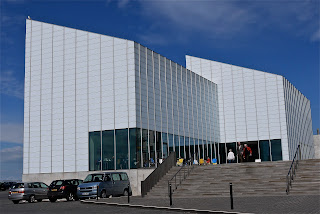
Opposite stands the stark, but imposing Turner Contemporary gallery designed by David Chipperfield Architects.

Inside, the gallery is spacious and the seaward side has a dramatic group of tall windows with a curiously compelling view out to sea. The area is famous for its light, highly valued by Turner, and is both effective and appropriate to make it a feature of the building.

We were now running out of time and perhaps did not give the rest of Margate the attention it deserved. We walked up past the gallery to the Winter Garden and downhill to King St where we detoured to find a surprising and rather incongruous restored 16th house - known, perhaps inevitably, as the Tudor House.


The section of King Street nearer the sea had a nice Georgian/Victorian appearance.


Now we we returned to the sea front and retraced our steps to the station. I see from Pevsner that we missed The India House of 1767, "the best house in Margate" and Drapers' Almshouses of 1708.

Conditions: warm and sunny.

Distance: about 3 miles.

Rating: three and half stars. Much more interesting thab might have been feared.