The lighthouse at Anvil Point
On a brief visit to Poole we saw a chance to make a little further progress along the Coast Path. We parked at Durlston Country Park and followed a winding tarmac path down towards Anvil Point to resume our route. According to the Trinity House website, the lighthouse dates from 1881 and was opened by Joseph Chamberlain, father of Prime Minister Neville Chamberlain.
There was a fine view down to the lighthouse as we drew closer. Out to sea the sun broke through the clouds in a few places creating bright circles on the surface: a searchlight from heaven.
Before reaching the lighthouse there is a small preserved stone quarry, with a little four wheeled cart, called a quarr, used to bring the stone up.
We joined the Coast Path, initially walking along a grassy area, but soon joining a narrower and increasingly muddy path. We rapidly formulated a law to the effect that the depth of the mud was inversely proportional to the width of the path - some of the narrow sections were extremely sticky.
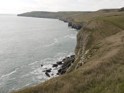
This section of the Coast Path is fairly straight, without major features. We went through a National Trust section named Belle Vue, although it did not seem any more belle than the adjoining areas. The first landmark was Blackers Hole and there were by now impressive views along the coast towards St Aldhelm's or St Alban's Head.
Another half a mile or so of struggle through the mud and we came to Dancing Ledge.
We found our way down the ledge itself and noticed that some climbers had descended from there down to sea level to make an assault on the cliff face further along. We naturally had a little dance on the ledge, doing some of our favourite jive moves.
We had planned this walk by reference to the map and now climbed the steep hillside leading to the ridge which runs parallel to the coast along this section - an ascent of about 50m. On the way up we saw our first daisy of the year, which we found strangely cheering. At the top we briefly sat and enjoyed the feeling of the warm sun on our faces - for a moment we felt that we might have been in Nice.
The walk back along the ridge was a delight by comparison with the walk out and we fairly sped along over the short grass. The sky had cleared somewhat and we were surprised by how blue the sea was in places.
The route continued over grassy paths interspersed with dry stone walls.
We reached Round Down and soon returned to the car.
Map: Explorer OL15 (Purbeck and South Dorset).
Distance: about 5 miles, of which about 2.5 was on the Coast Path. Distance covered now 12 miles.
Conditions: cloudy, some sunshine, about 9 degrees; did I mention that it was very muddy underfoot?
Rating: four stars.


No comments:
Post a Comment