Sunday, 26 March 2017

Barnstaple

The Albert Memorial clock

We are walking the South West Coast Path in the area around Barnstaple and I felt the town was worth a walk around in its own right. I also knew there were several almshouses to see. This walk was a combination of seeing the almshouses and following the town's Heritage Trail (but excluding the river bank as that is covered in our Barnstaple to Braunton Burrows walk). I started at the Albert Memorial Clock (1862 - this was quick work as Albert had died only in December 1861).

From here I walked along Litchdon St in search of the Penrose almshouses. I was struck by this fine, but sadly empty, Victorian building with coloured bricks and ceramic and terracotta tiles - Brannam's Pottery of 1886 by W C Oliver.


The almshouses of 1627 are a little further along the street. They make lovely composition with projecting buildings at the ends joined by a colonade with the main entrance in the middle.


You are welcoem to go in to find a courtyard with a water pump in the middle.


I was told that the caretaker was happy to show people the chapel (the right hand building on the street front) and took the opportunity. The lectern from where the Reader read to the almsfolk from the bible is still present along with a lovely plastered ceiling.

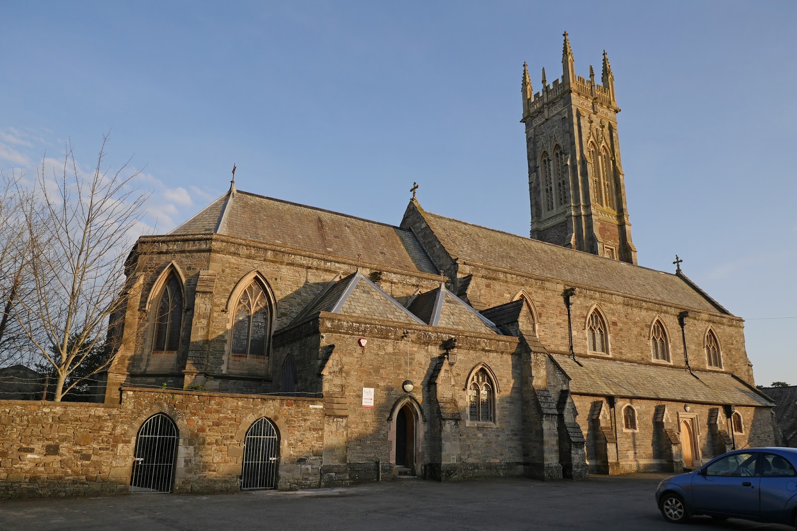
I continued along the street and headed towards the tower of Holy Trinity, a landmark. The church was revealed to be Victorian (1843-5, but partly rebuilt twenty years later). Pevsner describes the interior as dull and I took him at his word and didn't look inside.

I headed back towards the centre of the town along Trinity Street, passing the Salem Almshouses on the right. They were founded in 1834 by Charles Roberts for 24 men and women. There are three ranges, with the street side left open.


Regaining the centre, I headed along the High St, pausing to look back at the imposing 19th century Royal and Fortescue Hotel, where we are staying.


On the opposite corner was a small gift shop with exquisite art deco stained glass in the windows.


On the right of the High St I noticed this jolly building with nice stained glass and a sort of loggia at the top.


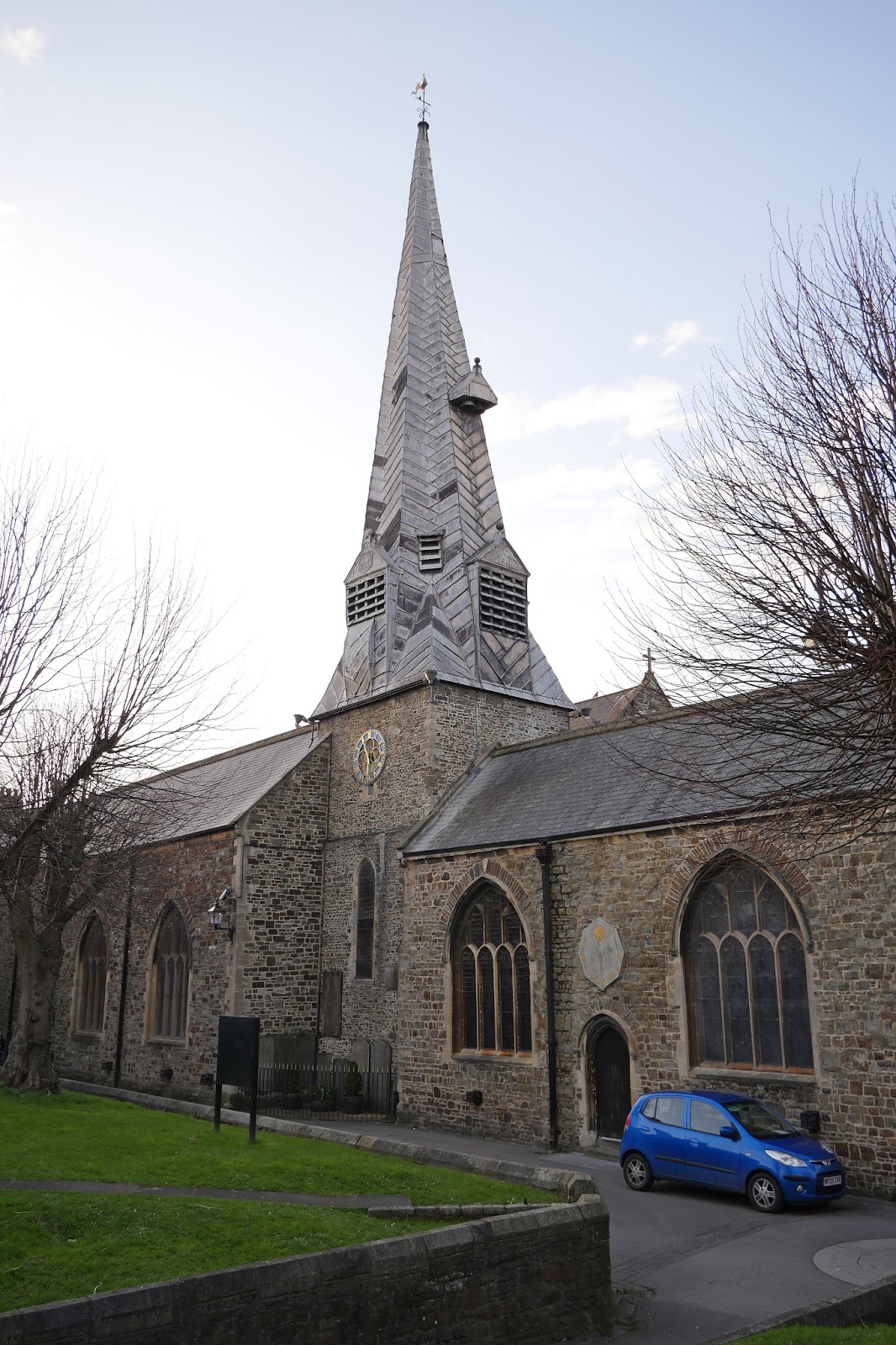
A bit further on I turned to the right to see the church of St Peter and Paul, with its distinctive tower of the late 12th or early 13th century and twisted spire which was added in 1388-9 (Pevsner).

Just beyond it is St Anne's chapel, an early C14 chantry chapel, now a museum. A chantry chapel was one built on private land, or within a church, endowed in the will of a deceased person). They were abolished at the Dissolution of the Monasteries.


Nearby in the narrow Church St were Paige's Almshouses (1656) and Horwood's Almshouses and School (1674 and 1659 respectively)

Returning to the High St, the next main building was the Guildhall (1826 by local architect Thomas Lee, a pupil of Soane and Lang).


Backing straight onto the Guildhall is the Pannier Market of 1855-6. It is 320 feet long. There are well-known Pannier markets in Bideford, Tiverton, Tavistock and Truro - so it seems to be a Devon thing. But what is a pannier market? According to the Plymouth Council website, the word pannier derived from the French for a basket. So a basket market. This wasn't modern enough for Plymouth who have renamed theirs the City Market.


I now retraced my steps down the High St and turned left into Boutport St to quickly be confronted by the art deco cinema of 1931 by W H Watkins of Bristol. The grotesques at the top of the pilasters are by Eric Aumonier.


Beyond the end of Boutport St is North Road and then Pilton Park. I was now in the suburb of Pilton, once a separate town and possibly older than Barnstaple itself (Pevsner). In Pilton St are the attractive Lower Almshouses dating from 1860.


At the top of the street are the Feoffee Cottages and Church Cottages, a very pretty group with the arch in the centre leading to the church of St Mary, founded in the 12th century and once belonging to Malmesbury Abbey. They date from 1849.


I headed back to the hotel along Under Minnow Road, passing the redbrick Lake Almshouses of 1863, and continuing past Pilton Park via Abbey Road.

Conditions: pleasant late afternoon sunshine.

Distance: perhaps 5 miles.

Rating: four stars. A delightful town, well worth exploring.

Saturday, 25 March 2017

Instow to Barnstaple (South West Coast Path 93)

Instow seen from Appledore

We sent off from the car park behind the dunes in Instow and followed the edge of the estuary northwards. The tide was out and there was a wide expanse of mud and sand. Now we were in the Taw estuary and looked across to Crow Point which we will pass inland of tomorrow.


Before long there was another spectacularly derelict boat (we saw several yesterday - they seem to be a feature of the area). The grafiti reads "Davy Cameron's offshore treasure map". I am writing this on the day Brexit was declared. It seems appropriate somehow - people who believe in treasure maps are often deluded.


We carried on along a winding trail through marshland which eventually rejoined the tarmac of the Tarka Trail, which had more bicycle traffic than yesterday's section. To the left were several marshy nature reserves.


A bit later, a tunnel of trees provided some variety.


We reached Fremginton Pill (Pill seems to be a local word for a Creek) and a view across to the north bank of the Taw estuary. The stone monument on the left was a memorial to a "local fisherman and character" John 'Dinger" Bell who drowned 30 years ago.


We walked across the former railway bridge and had this view of the Pill with the obligatory derelict boats.


On the other side was the former Fremington railway station now converted into a cafe and doing a roaring trade.


We plodded on towards Barnstaple approaching an attractive road bridge which was soon followed by a cutting.


Here I was delighted to see a  Brimstone and my first Peacock of the year. A sign board revealed that the sides of the cutting were being carefully cultivated to produce a series of colourful flowers. There was a fine showing of Primroses and a few Snake's-head Fritillary (Fritillaria meleagris).


As we reached the edge of Barnstaple, the splendid Torridge Bridge opened in 2007. It is an example of a balanced cantilever design. A rather negative article on Wikipedia describes it as the Barnstaple Western Bypass and expresses worries about the effects on seabirds and the difficulty of reopening the Barnstaple to Bideford Railway.


We completed our walk by crossing Barnstaple's fine Long Bridge (I will use it's picture to head the post of tomorrow's section). It's not as long as Bideford's (yesterday) but is still a great sight.

Distance: 7.0 miles.

Grading: Easy.

Map: Explorer 139 (Bideford, Ilfracombe & Barnstaple )

Rating: Three stars. A bit samey.

Friday, 24 March 2017

Appledore to Instow (South West Coast Path 92)

Appledore seen from Instow

We are back on the Coast Path after an 18 month absence (I ruptured a tendon in my ankle). We have done quite a lot of walking meantime, but this will be the first time we have done four successive days in that time. We should really resume the walk at Bude, but it seemed more sensible to start with an easy section. We start off from the car park in Appledore and wander along The Quay, made in 1845 place of a number of private jetties. We turn right into Marine Parade, where we enjoy this interesting terrace.


We pass a small shipyard and various industrial operations to reach the estuary of the River Torridge (Appledore is near the mouth of the river where it meets the river Taw before flowing into the Celtic Sea. As we turn right along the river back we are struck by a group of derelict boats.


A bit further on, in a small wooded bay, is this boat, apparently in effect a house boat - we saw someone who was presumably the owner hard at work with a chain saw.


We continued along the side of the river to gain increasingly clear views of the impressive Torridge Bridge. The bridge was opened in 1987. Sadly, it seems that it has been the site of several suicides.


We were now in the orbit of Bideford and soon had a clear site of its famous Long Bridge. This is said to have been first built by Sir Theobald Grenville in the 14th century and the present structure is supposed to date from the 15th (Pevsner). Pevsner adds that much of the present stonework dates from repairs in 1638 and widening in 1865. It is impressive however at 677 feet long.


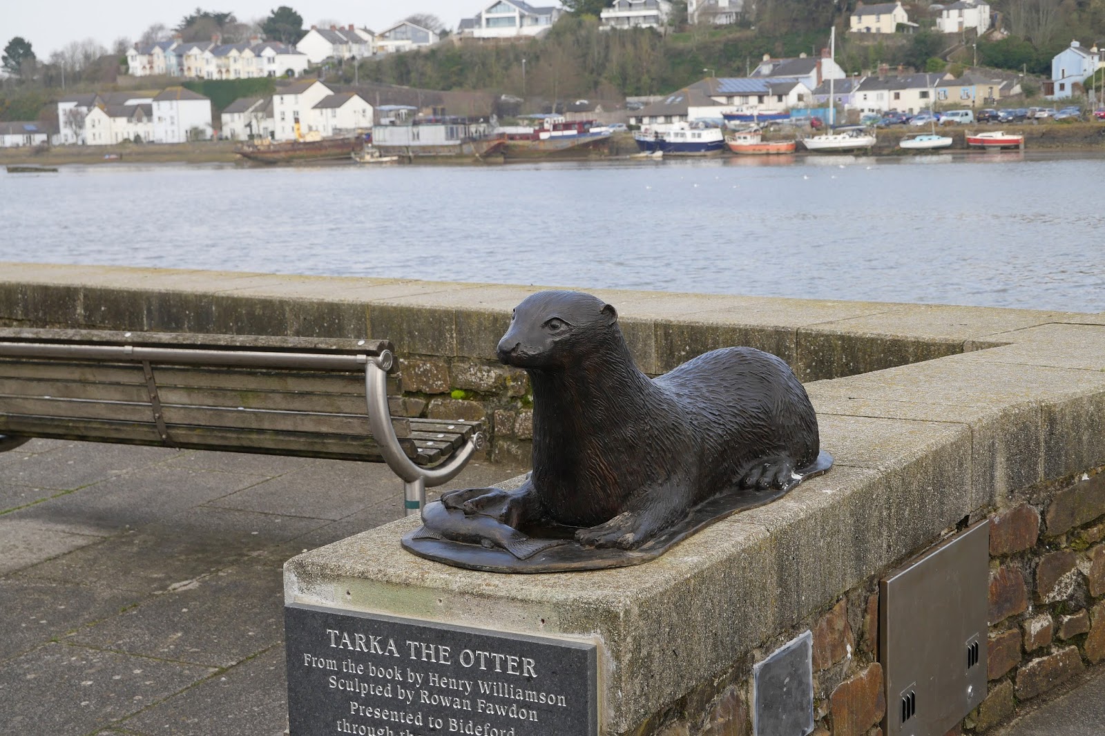
Just before the bridge is a statue of Tarka the Otter, hero of the stories by Henry Williamson.


Looking back from the bridge is the Town Hall and Library (on the left), mostly of 1905 by J A Dunn of Birmingham. Pevsner describes it as "quite a playful free Tudor". It is certainly rather charming.


Having crossed the bridge, we turned left to walk up the other bank of the Torridge and now we were sharing the route with the Tarka Trail. It apparently follows the route taken by Tarka the Otter and covers a total of 180 miles (290 km) in a figure-of-eight route, centred on Barnstaple. This section follows the disused, but now tarmaced railway line between Bideford and Barnstaple.

Soon we saw another, even more striking, derelict boat.


We passed under the Torridge Bridge and passed the entrance to Tapeley Park, a house of about 1700 remodeled in a neo-Renaissance style in 1898-1916. We had earlier caught a glimpse of the house on its high vantage point.


Walking along a tarmac track is not that exciting, but things picked up when we reached Instow where the former platform remains intact complete with benches, despite the new housing behind it.


At the end is the original signal box of about 1855 with the remains of the level crossing.


After this the SWCP and the Tarka Trail parted company for a while and we walked along the seafront (you can just make out the open sea at the mouth of the combined estuary of the Torridge and the Taw) to the car park behind the dunes at the north end of the village.

Distance: 7.1 miles.

Grading: Easy.

Map: Explorer 139 (Bideford, Ilfracombe & Barnstaple )

Rating: Three and a half stars. Quite interesting.

Tuesday, 21 March 2017

Tewkesbury

Tewkesbury Abbey

The Abbey is Tewkesbury's greatest attraction, but there is lots else to enjoy. I am here to explore the town with my friend Merv/ We park near the Abbey, on a car park with warnings of its propensity to flood, and head there straightaway.

The first impression of a great, mainly Norman building and it was indeed started in 1087 and consecrated in 1121. The abbey was founded in 1107 before the completion of the church. The East end clearly has Gothic additions and these date from the 1400s.

Inside the Norman columns are solid and monumental, almost devoid of capitals. The centre rib of the roof has bosses representing the life of Christ.


Heading straight down the nave you come to the crossing, whose roof has a wonderful pattern of lierne vaults.


Beyond it lies the Quire with an even more astonishing roof. The lierne vaults here are overlaid with Yorkist badges of the sun in splendour. These commemorate the Yorkist victory over the Lancastrians at the battle of Tewkesbury in 1471.


The abbey was restored by Sir George Gilbert Scott in 1875-9 and his proposals so outraged William Morris that he founded the Society for the Protection of Ancient Buildings in protest.

Emerging into daylight, the next delight was the Russell Almshouses. They were founded 1674, rebuilt in 1831, modernised between 1958-1960 and re-instated in 1989. I have found nothing on why they were reinstated. Quite a pleasing group however.


Heading further west we came to the Abbey Gatehouse. It dates from the 15th/16th century and was restored in 1849. It is not very imposing.


We headed now towards the River Avon - this section is known as the Mill Avon. And here is the Abbey Mill, a flour mill which opened in 1865.


At the point we headed away from the river to join the High St and immediately noticed a number of impressive timber-framed buildings with large (larger than usual, we thought) jetties. This one, now a branch of the Halifax Building Society was especially good.


On the right, further along, was the first of many alleys for which the town is known. Merv thought they were related to the existence of long burgage plots (long but narrow pieces of land in a town). Such plots were often separated by alleys.

Back on the left hand side was the rather bijou Town Hall, built in 1788, enlarged about 1840 and altered in 1891 - and now the home of the Town (rather than Borough) Council


We now made another foray towards the river to see the imposing, but sadly derelict, Healings Flour Mill of 1865.


We returned again to the High St and turned left into Mythe Road, passing the closed down Old Black Bear pub. Being the oldest pub in Gloucestershire doesn't seem to have been enough to keep it going. Further along we crossed the Avon and admired the enormous 1930s pumping stations which try to manage the complicated water flows stemming from Tewkesbury's position where the Avon and the Severn converge.


Walking back we could see, the lock gates on the left, the small channel which joins the two.


We returned along Mythe Rd and turned right into the High St, taking a left to get a closer look at this rather striking church. It is Holy Trinity of 1837 by Ebenezer Trotman.


We reached Barton St and turned right to head back to the car along Church St. This street was distinguished by this exceptional terrace of half timbered houses. I have never seen anything like it.


Pevsner says that they were probably built by the monks of the abbey, and are therefore pre-Reformation, to let to tenants in the town as a speculative development. They would then be "one of the earliest surviving examples of uniform medieval town development".

Conditions: bright at first, becoming a bit greyer.

Distance: maybe three miles.

Map: Explorer 190 (Malvern Hills & Bredon Hill)

Rating: four and a half stars. An excellent day out.