Tuesday, 29 September 2020

The Hardy Monument and Littlebredy


                                                                                                                The Hardy Monument 

Today we finally got round to visiting the Hardy Monument and doing a circular walk inland from it. The Hardy Monument is a twenty-two metre (70 feet) single column built of local Portland stone and perched on the summit of Blackdown Hill, above the village of Portesham. Although the Monument looks like a chimney, it is in fact intended to represent a spyglass. The Monument was restored in 1900 by Hardy's descendants and given to the National Trust in 1938.

 The Monument commemorates Thomas Masterman Hardy who was born in nearby Portesham in 1769 and died in 1839. He was the Captain of Nelson's flagships, especially the Victory, and was later an Admiral himself. He was principally famous for being the recipient of Nelson's dying words - "kiss me Hardy".

The view above conceals a doorway in the rear of the monument. There are 122 steps inside the monument and a small viewing platform on top. It is of course currently closed.

Before we set off we noted the splendid views down towards Portland.

We headed downhill passing a tree with a series of carved rocks bearing the message: Be still, Close your eyes, Be still, Listen. Obviously we were in too much of hurry to get into our walk to pay any attention.

The path continued through woodland and then a field-edge path to reach a view point looking down to near to Abbotsbury. You can see the Fleet along with the Chapel of St Catherine on its hill.

 We continued along this path to enjoy further wonderful views ...

... and then reach a road junction.We now headed inland along a field edge path to reach the KIngston Russell Stone Circle, a rather minimal circle if truth be told. We wondered if the two people sitting there had just had a domestic.

We headed across the large field and passed some ancient grassy mounds. The next section was quite stressful in that the directions suddenly became sparse and approximate. We struggled our way across fields and streams to eventually reach Littlebredy. This is an estate village which was once the property of Cerne Abbey. We passed the Village Hall and another building ...

... to reach the attractive church of St Michael and All Angels. It is a medieval church largely rebuilt in the mid 19th century.

This was quickly followed by the Bridehead Estate Estate Yard with its Blacksmiths Cottage and Old Forge. We then followed an estate road, catching a glimpse of Bridehead through the trees. The house dates from 1630, but was was rebuilt and extended in the mid 19th century. 

We climbed a steep hill to reach a road, which we soon left to follow a woodland path for a mile of so back to the Monument. We missed a turning towards the end and overshot the Monument, but fortunately a dog walker pointed us towards a path which led upwards to it. 

Conditions: bright and sunny.

Distance: 7 miles.

From: 50 walks in Dorset.

Map:  Explorer OL15 (Purbeck & South Dorset).

Rating: four stars.

Saturday, 26 September 2020

The Pepperbox

                                                                                                                The Pepperbox

We started today's short walk at The Pepperbox on Pepperbox Hill near Salisbury. The building gets its name from its shape, although the doors and windows have all been bricked up. It is said to be one of England's earliest follies - dating to before the term was invented in the 18th century. It is thought to date from 1606 and be the work of Giles Eyre of Brickworth House, hence the alternate name "Eyre's Folly". Accoring to Wikipedia "The building's original purpose is unknown, though theories include that it was built to provide Eyre with views of Longford Castle or to provide local landowners' wives, including Eyre's wife Jane, a lookout tower to watch the hunt." Wikipedia also floats the idea that it may have been influenced by the Tower of the Winds in Athens.

The walk route required us to head due south and we soon had a fine open view in that direction. Longford House can be seen on the left of this photo and Salisbury Cathedral on the right. The theory that the Pepperbox was designed to provide view of Longford House isn't very convincing!

Taking our lives in our hands we crossed the busy A36 and headed up a track to emerge into grassland. We followed a track heading south and soon had a fine view over fields to the right.

 After this we were in woodland with fields to the right.

We emerged to turn left into a farm track with a massive field on the left and at the end turned left along a field-edge path, now heading north. We soon had to turn into woodland and only got slightly lost as we negotiated innumerable twists and turns.

We then followed another woodland path, this time in a narrow strip with fields visible on both sides. We were very taken by this large tree.

Emerging from the wood we followed the left edge of a large field into more woodland which soon led us back to the A36.

Conditions: bright and sunny.

Distance: 4 miles.

From: Wiltshire: from Salisbury to the Kennet (Jarrold).

Map:  Explorer 130 (Salisbury & Stonehenge).

Rating: three stars. The Pepperbox and its history were interesting and it was great to be able to see Longford House, albeit in the distance. But the actual walk was a bit disappointing.

Thursday, 24 September 2020

Kintbury and Hamstead Park


                                                                                                                            Kintbury Lock

We parked by the Kennet & Avon canal to start our walk at Kintbury Lock. We headed east along the tow-path and soon passed this unusually large craft.

After half a mile or so we passed the handsome Shepherd's Bridge ...

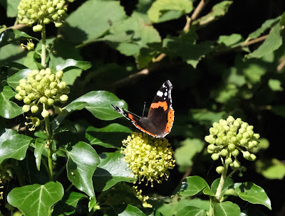
 ... and soon became aware of a large number of Red Admirals attracted by the greenery. 

A little further on was one of the wartime pill boxes that are to be found all along the canal as far as Reading. This one was in better shape than many of the others.

 We reached Hamstead Lock ...

... and left the tow path here crossing the bridge and then the River Kennet, which at this point is on the right of the canal (it is sometimes on the left).

We entered Hamstead Park and walked up past the remains of the Norman motte and then past the church to reach some imposing gate posts (several other sets can be seen over to the left). They are the remnants of a mansion built for the first Earl of Craven between 1663 and 1697. The house burnt down in1718.

We walked through a group of attractive houses, apparently former barns ...

... to cross a road and then make our way across various fields, mostly well stocked with cows. At length we had a high level view of Shepherd's Bridge. This is quite unusual as the canal is usually only visible near ground level.

From here we climbed across fields to join a minor road into Kintbury. We admired the former watermill buildings ...

... and the pretty bridge over the Kennet with its beautiful Maple tree.

Conditions: warm at first, becoming grey and cooler.

From: Walks in the Kennet Valley and beyond (West Berkshire Ramblers).

Distance: 6 miles.

Map: Explorer 158 (Hungerford & Newbury).

Rating: four stars.

Tuesday, 22 September 2020

Ashdown House and the Ridgeway


                                                                        Ashdown House

Today's goal was to do a circular walk involving a length of the Ridgeway and other tracks and hopefully to get close enough to Ashdown House to take some photos of it (we knew it was closed). We (Merv and I) started just south east of Ashbury, where the Ridgeway crosses the B4000. The spot is known as Ashbury Folly for some reason - no folly could be spotted. We headed west and after half a mile turned left down a track heading towards Ashdown. There was a lovely view over the downs to our right.


A left turn across fields led us to the rear of Ashdown House and our first view (see the head of this post). The house was built in 1662 by William, Lord Craven, for Elizabeth, the daughter of James I of England and VI of Scotland. Her husband, Frederick, the Elector Palatine, was defeated at the battle of White Mountain and Elizabeth was thereafter known as the Winter Queen (echoes of Game of Thrones!) After Frederick's death Craven looked after Elizabeth and it is said that they married in secret, although there is no evidence for this. Sadly, Elizabeth died before the building of the Dutch-style house was complete.

A little further along there was a more square-on view of the back of the house which made the two pavilions visible.


We headed anti-clockwise passing Ashdown Farm this disused, but rather imposing, stable block.


We passed the main entrance to the House and were lucky to get this shot up the drive as a car drove in. 

We crossed the B4000 and began a steady climb up the grassy hillside, with this initial view back ...

... soon followed by this view which highlights the downs at the rear of the House.
 

 We continued north east and reached this enticing track, still heading north east.

We could see a series of parallel tracks to the left all of which would head towards the Ridgeway. We so enjoyed the track we were on that we ended up taking the last of the tracks and making our walk longer that we had planned.

Soon we were rewarded by  quite a large herd of deer charging across the track and then regrouping in the middle of a large field.

Eventually we rejoined the Ridgeway and turned left along the track.

Some distance later we came to Weyland's Smithy, an imaginative name for a long barrow. We passed by here in April 2015 when we were doing the Gramps Hill to Ashbury Folly stretch of the Ridgeway. It looked rather different with the trees still in leaf.

Soon afterwards we reached Ashbury Folly.

Conditions: warm and sunny.

Distance: 8 miles.

Map: Explorer 170 (Abingdon, Wantage and Vale of White Horse)

Rating: 4 stars

Sunday, 20 September 2020

Coate Water


                                                                        Coate Water

Today's walk is around Coate Water, a country park on the edge of Swindon, and beyond. It's a nice place for a stroll, but there is also an arc deco diving platform (although swimming has been banned since 1958), fishing swims, a cafe and areas of grass for play. Although it looks like a lake, Coate Water is a 56-acre reservoir built in the 1820s as a headwater tank for the Wiltshire and Berkshire Canal. The canal was abandoned in 1915. In the 1970s a smaller lake was created as a flood storage lagoon, which later became Wiltshire's first Local Nature Reserve.

We walked clockwise around the lake passing the Reserve and then following a wide track, shared with cyclists, which led down to the M4 moroway. There was a remarkable spiral bridge, larger on the north side than the south side, which enabled the cyclists to not have to dismount.

We continued along field paths and some woodland to walk along a pleasant valley and then along the edge of a large field to emerge on a road. This led down to a bridge over the M4.

We crossed the bridge and walked along two sides of a large field - all very noisy - to find in the corner a fine pair of sarsen stones.

In the corner of the next field we passed through an absolute quagmire of cold muddy water which went over our boots as we went towards the only gate. Soon after this we re-entered the Country Park and had a lovely view of the bottom end of the reservoir.

Soon after this, there was a lovely avenue of (beech?) trees.

We then followed the line of the lake on our right to return to the start.

Conditions: bright and sunny.

Distance: 4 miles.

From: 100 walks in Wiltshire.

Map:  Explorer 169 (Cirencester & Swindon).

Rating: three stars. A nice change.

Thursday, 10 September 2020

Thorncombe and Forde Abbey


St Mary's church, Thorncombe

We started today's walk from St Mary's church, which was rebuilt in 1866-7. There are, according to Pevsner, wonderful 15th century brasses inside the church.

We headed away from the church towards the north west, being immediately struck by the dramatic countryside.

We followed a series of paths quite comfortably until we reached a very large field where none of the route description in the walk book seemed to apply. We used our skill and judgement and managed to find our way to the Forde Abbey fruit farm and the road which was our target.

We followed the road for a short while then turned right into a massive field of sweetcorn, enlivened only by a pretty set-aside at the end.

We wondered what these (slightly out of focus) attractive blue flowers were.

Now across a field to reach a road and the entrance to Forde Abbey, which we had hoped could be visited as a detour from the walk. We walked up the drive to see in quick succession the dormitory range (or Dorter) ...

... and then the beautiful exterior of the main part of the Abbey.

The Abbey was founded in the 12th century, but like so many others, was in decline by the the time of the Reformation with an abbot and only 12 monks. It was then in ruins until 1649 when it was bought by Edmund Prideaux who created an unusual mansion from former parts of the monastery.

The Chapel (once the Chapter House) is on the right with the Abbot's Hall, the West Dining Room and the Drawing room arranged from right to left. 

The gardens were laid out in the 18th century and include the Long Walk with cheerful flower plantings on both sides, and three ponds. We rather liked these two wart hogs under a tree.

A high point in the gardens offered a lovely lateral view of the main front of the House and part of the Long Walk and Long Pond.

Leaving the Abbey we crossed the River Axe, only a small stream here, with deep banks. 

We followed the river for a while and then headed away from it, passing this curious piece of landscaping. We couldn't work out what was going on.

After this, a narrow path through another large field of sweetcorn, several field paths and a small copse led us back to the village.

Conditions: warm and sunny.

From: 50 walks in Dorset (AA).

Distance: 5 miles, plus the wander round Ford Abbey.

Map: Explorer 116 (Lyme Regis & Bridport).

Rating: four stars.