Thursday, 10 August 2017

Kimmeridge to Lulworth

Looking towards Tyneham Cap

Out friends John and Anne were visiting and wanted to see something of the South West Coast Path. We took them to what is arguably one of the very best sections on its entire 630 mile length. We parked at the car park at Kimmeridge and headed west towards Tyneham Cap. Moments after I too this picture a shepherd on a quad bike roared up and very quickly rounded up the sheep. It was a wonderful sight. (Interestingly, a shepherd's cottage is marked on the map, but I rather doubt that it was where this modern shepherd came from.)

We headed round to Hobarrow Bay, with rocky cliffs ahead.


We climbed up to the cliff top and had a great view back over Kimmeridge Bay and as far as St Aldhem's Head.


Soon the path began the long descent towards Warbarrow Bay. The low point is Arish Mell.


As we descended the curious outcrop of Warbarrow Tout became visible at the east end of the bay. Inland is the village of Tyneham, occupied by the Army during the Second World War and still part of the extensive MOD ranges.


And soon after that there was a more close up view of the lovely bay with its ring of chalk cliffs.


After coming down to sea level, the next task was to climb up to Flowers Barrow, an Iron Age hill fort. It covers about fifteen acres today, but at least a third of the original hill fort has been eroded and has tumbled into the sea. It is 160m above sea level.


As we began our descent from Flowers Barrow Lulworth Castle could be seen inland. It is a 17th century construction set in a large park. We have for some reason never explored it.


Now began the steep descent to Arish Moll - sharply followed by steep climb to Bill Hill.


This is the view back from the top of Bindon Hill. We last walked this part of the coast in August 2011 and at that point you could walk along the narrow path right at the top of the hill - now, because of erosion, the safe path is some way below the top, depriving you of the fine views previously available.


We passed Mupe Rocks, far below, and headed along the high path towards Lulworth.


The drawback of of this is we were almost deprived of a view of the wonderful cove, but I manged to remember the right path to make a short detour along.


At the end of the hill top I planned to descend Bindon Hill in the hope of seeing a few butterflies. This was partially successful in that we managed a few Chalkhill Blues and a lone Marbled White, but a path diversion took us a long way inland.


Conditions: warm and sunny.

Distance: about 8 miles.

Map: Explorer OL15 (Purbeck and South Dorset).

Rating: five stars.

Wednesday, 9 August 2017

Macclesfield

Arighi Bianchi

I had been to Macc, as the locals call it, before but never had a proper look around. I started my walk at the station and immediately walked away from it in the direction of Buxton to see the wonderful Arighi Bianchi shop (when we bought some dining room furniture many years ago) of 1882-3. Along the Buxton Road on the right, are the attractive Fence Almshouses of 1895.


Returning to the station I climbed the celebrated 108 Steps towards the town centre. They could do with some attention.


You emerge behind the medieval church of St Michael and All Angels (previously All Hallows according to Pevsner). Much of it was rebuilt around 1900 by Sir Arthur Blomfield, but the oldest remaining parts are on the south side: the Savage chapel (1504) on the right and the Legh chapel (1422) on the left.

Inside, I found the Savage chapel to be more interesting with some wonderful stained glass (the three Graces) by Morris & Co from cartoons by Burne-Jones.


To the right of the church as you exit onto the Market Place is the Georgian Town Hall of 1823-4 by Francis Goodwin.


On the opposite side of the Market Place is the curious "Ye old shop" (at least it's not Ye olde shoppe!) of 1897, with art nouveau style decoration.


Off to the left, in Mill St, was a nice art deco shopfront.


I headed in the opposite direction, passing the Tourist Office where a kind lady gave me a copy of the Macclesfield Heritage Trail, to reach Jordangate. On the corner was the former Macclesfield Arms, once a coaching inn and then a hotel. I must say it doesn't look like one. Opposite was the imposing Jordangate House, rather spoilt by the blue colour scheme.


Now along King Edward St past the King Edward St chapel, one of the oldest Dissenting chapels, dating back to 1690. Unfortunately it was closed. Further along on the right was a pub with a thoroughly odd name of The cock in treacle.

At the junction with Churchill Way and off to the right were Stanleys Almshouses, founded in 1870. Four blocks form three sides of a courtyard. Two others were added in 1927 extending the development into Cumberland St.


I turned into Churchill Way and then right into Chestergate. In Bridge St, on the right, I spotted this impressive building with its battlemented tower. It turned out to be the Drill Hall of 1871.


Returning to Chestergate, I passed the interesting Picturedrome, the town's first cinema. It was converted into a bingo club in the 1970’s into offices in 2000.


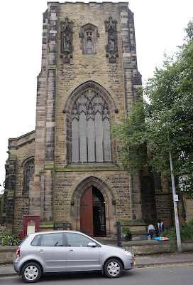
My real purpose in heading out here was to see A W N Pugin's St Alban's church in Chester Road. It was funded by the Earl of Shrewsbury and built 1839-41. It was intended to have had a much larger tower but this was never finished.


Inside there is a rood screen as Pugin thought should have and some lovely stenciled decorations.


Heading back into town I passed Christ Church (1775-6), somewhat reminiscent of St John the Baptist in Knutsford which I saw the other day. It was built by Charles Roe, a wealthy local businessman. The tower was deliberately raised to a height to match that of St Michael and all Angels.


I returned to the centre via Bridge St and Roe St to reach the Heritage Centre. It is housed in a building which was once the Sunday School. I found this quite astonishing until I read in the Heritage Trail booklet that 1600 children who worked in the silk industry for which Macc was famous attended the school.


From here back to the station passing near the Silk Museum, but now with no time left to have a look.

Conditions: grey, but dry and mild.

Distance: about 3 miles.

Rating: four stars. Interesting and varied.

Friday, 4 August 2017

Porlock Weir to Minehead (South West Coast Path 103)

The end of the South West Coast Path

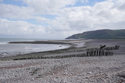
This is the final leg of the SW Coast Path! We set off from Porlock Weir in light drizzle, looking across the rocky beach towards Hurlstone Point. A small tower can just be made out part-way up.


We followed the road through the village and turned left to walk along the back of the beach for a while, passing the wooden stakes indicating the oyster beds.


Soon we had to turn inland because of a "breach". We followed a well-trodden path which eventually turned back towards the sea, passing a dramatic stand of dead trees.


We passed through the pretty village of Bossington, where we especially admired the brick columns of the cattle byre attached to one house.


We then began a long climb, passing inland of Hurlstone Point and thereby missing the small tower which we had seen from afar. I learn from Google that it is a coastguard lookout tower which was built in 1902, and remained in use until 1983.

We were now climbing Hurlstone Combe where we soon reached the heather line and plodded on up the long slope.


 At the very top there was a great view back towards Porlock Weir ...


... and also a fine one inland towards Porlock.


Soon afterwards we ignored the sign for the "Rugged Coast Path" to continue along the regular Coast Path across moorland, passing Selworthy Beacon at 308 metres, only 10 metres lower than the Great Hangman which we climbed recently on the Combe Martin to Hunters Inn section. It turned out that we had somehow drifted off the official path at this point and it took us a while to edge our way back onto the correct route.

By the time we achieved this we were opposite Grexy Combe with North Cliff largely out of shot to its right. The trees were quite picturesque.


As we approached Minehead we were rejoined by the Rugged Coast Path. We were still over 200m above sea level and soon the path made a zig-zag turn towards the sea. The variations in colour were fascinating.


We descended steadily and entered some woodland, emerging eventually onto a minor road which took us into Minehead. It was interesting to see the stony beach in the foreground and the sandy one in the distance. We concluded that at some point in time the rocks had been cleared from the sandy area.


We headed inland in search of the Duke of Wellington in Wellington Square. We passed these rather lovely Coastguard Cottages built in a lovely red sandstone, which we quickly discovered was characteristic of the town.


Just before Wellington Square is Mansion House Lane where the Quirke Almshouses are to be seen. Founded 1630 by Edward Quirke, merchant and mariner, and restored 1986. Note the bellcote at the far end: it reputedly houses a bell from one of Robert Quirke's ships.


Wellington Square is home to St Andrew's church, in front of which is this fine statue of Queen Anne, by Bird who made the similar one which stands outside St Paul's in London.


We now adjourned to the rooftop beer garden of the Duke of Wellington to celebrate our completion of the South West Coast Path with a nice bottle of Wetherspoon's reasonably priced Moet et Chandon.

Conditions: Quite warm, but mainly cloudy.
 
Distance: 9.5 miles.
 
Map: Explorer OL 9 (Exmoor).
 
Grading:  Moderate.
 
Rating: four stars.

Thursday, 3 August 2017

County Gate to Porlock Weir (South West Coast Path 102)


 View inland from County Gate

Just two more stages to go and we will have completed the South West Coast Path! We start out from County Gate, the car park on the Devon-Somerset border, and head downhill towards the coast. Soon there is a very pleasing view over the purple heather down to the blue sea.


We carry on downhill into woodland and reach a combe with a lovely stream falling down the hillside.


Gradually we realise that this walk is an extension of the second half of last one we did (from Lynton to County Gate) – a reasonably level path about two-thirds of the way up the cliff. It is very green, but there is not much sign of life (although there were clearly loads of bluebells here earlier in the year).  There are no views because the trees are quick thick and the coastline is fairly straight. There are no boats or ships in sight either.

This continued until we reached a sign telling us the path ahead was closed because of a landslide. A steep climb followed to a new path on a higher contour.


Soon afterwards there was a repeat to an even higher point. After this we turned inland and arrived at the hamlet of Culbone, with its lovely church nestling at the back of the combe.


Another mile or so, including a gradual descent, brought us to the wonderful entrance to the Worthy Toll Road.


We carried on down to Porlock Weir and snatched this view of the small harbour. There are three pubs and not much else. The rocky beach is not too brilliant either.


Conditions: Mild, but quite a lot of drizzle.
 
Distance: 6.2 miles.
 
Map: Explorer OL 9 (Exmoor).
 
Grading:  Moderate.
 
Rating: three stars. Rather underwhelming.