Thursday, 30 June 2016

Stoke Hill to Warminster (Wessex Ridgeway [Wiltshire] 6)

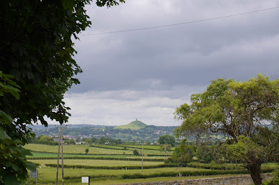
View over Salisbury Plain

We resume the Wessex Ridgeway at Stoke Hill overlooking Salisbury Plain from about 220m. We follow the road as far as Coulston Hill and then continue along a track. There are lovely views over the Plain, which in this area seems to contain a number of delightful combes and dry valleys.

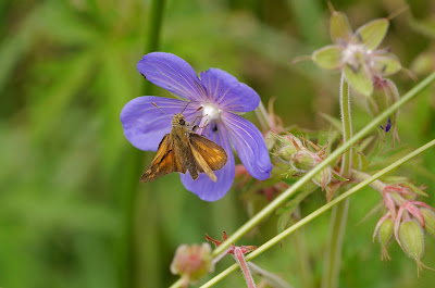
We ignore the temptation of the White Horse Trail on our left and continue down a hedged path looking for the next left. There is lots of Meadow Cranes-bill around and this one was host to a Large Skipper.


When we do turn left there is a lovely view through a field gate of the direction of progress: the chimney of the disused cement works just outside Westbury is a landmark for miles around.


We head diagonally downhill and pass Westdow Farm to tunr left again to follow a narrow path next to vast field of Oilseed Rape. The field margin has a solid band of Poppies and some more Meadow Cranes-bill provides a beautiful counterpoint.


Soon after this we head due west, now following the boundary of the MOD firing range - we can hear small arms fire from time to time. In the hedgerow we spot this lovely yellow flower, which we later identified as Common Toadflax.


Now we started to see cows grazing on the MOD ranges. Surely they are not used for target practice?


At length we reached Bratton Camp Fort, an Iron Age hill fort where there were also Neolithic long barrows.


Just round the hillside is the dramatic Westbury White Horse. According to the helpful plaque, "local records suggest that the horse was originally cut in the late 1600s, probably to commemorate the supposed Battle of Ethandun, thought to have taken place at Bratton Camp in AD 878."


The horse had to be re-scoured from time to time to keep it looking good. The last recorded re-scouring was in 1853: a hundred years later it was covered in white-painted concrete. We were frankly shocked by this - we had already detected something rather false about it from the horizontal and vertical lines.

A little further on we admired the slope of Westbury Hill with Westbury itself beyond.


We continued past a massive chalk pit and continued along the Imber Range Perimeter Path. We were still of course skirting the MOD ranges, although the immediate prospect was of a cornfield with a dense population of poppies.


Soon we took a left and headed down a steep hill towards the bottom of a long dry valley.


The climb back up was more gradual and at the top we unaccountably missed the correct path on the left, emerging on the road that leads up from Waminster to the rifle ranges. We weren't sufficiently upset to retrace out steps and simply plodded on down the hill. Just before we reached the car we were surprised to see this old mile post on the left hand side, which had presumably been moved from its original location into this dead-end road.


Conditions: mild, cloudy.

Distance: 9.3 miles. We thought it was going to be about 7 miles. The planners of the walk were duly chastised for their incompetence and have vowed to measure future legs more carefully.

Map: Explorer 143 (Warminster & Trowbridge)

Rating: four stars.

Thursday, 23 June 2016

Market Lavington to Stoke HIll (Wessex Ridgeway [Wiltshire] 5)

View towards Gibbet Knoll from West Lavington

What better way to pass Referendum day than continuing our walk along the Wessex Ridgeway in Wiltshire. We picked up the route at Gibbet Knoll, just up the road from Market Lavington. It was mild but hazy. We soon became aware of a great profusion of intensely coloured Dove's-foot Crane's-bill (Geranium molle) along the way side.


After walking along the wide track for a while, past some police supervising the recovery of what appeared to be an abandoned vehicle, we turned right into a narrower path towards West Lavington. Here we quickly spotted a few Large Skippers, my first for the year, and this Narrow-bordered Five-spot Burnet moth (a bit of a mouthful!) on Devil's-bit Scabious.


We arrived at the southern end of the village, passing this lovely house, which I am pretty sure is the late 17th century Parsonage described in Pevsner.

A bit further on along another track we passed the church of All Saints. This 13th century church had its tower added in the 14th century and then extended in the early 15th.


Now we climbed steadily, spotting a couple of Small Tortoiseshells, to reach the wide open grassland of Strawberry Hill. To the left a wide flower margin and to the right a much narrower one; in between, a wide grassy path.


We started to see quite a few orchids - this Common Spotted one and a number of Pyramidal ones too.


Gradually some butterflies revealed themselves from the grass: lots of Meadow Browns,  a few Common Blues, a Small Heath and some Marbled Whites, with this one being very obliging.


Then there was a descent to a valley bottom at 106m and quite a stiff climb to reach the Imber Range Perimeter Road at 192m. This is the view back from about two-thirds of the way up: beautiful grassland, with loads more orchids, but few butterflies.


It remained only to walk a mile or so along the road to where we had parked the car.

Conditions: mild, cloudy, muggy.

Distance: 7 miles.

Map: Explorer 130 (Salisbury & Stonehenge) and 143 (Warminster & Trowbridge)

Rating: four stars.
Tuesday, 21 June 2016

Collard Hill


Collard Hill

I am visiting Collard Hill in the hope of seeing a Large Blue. It's a bit late in the day, but still quite warm so perhaps it's possible. You park outside the nearby Youth Hostel and walk along a track marked with blue posts towards the hill itself. There are lovely grassy areas immediately by the path and within moments I spot this Bee Orchid, so at least there will be something to photograph! I seem to be taking many more flowers than butterflies at the moment!


Off to the left I notice that a desire path has been beaten to a gate on the left. I go to investigate and am delighted to see this great view across to Glastonbury Tor.


The path now goes through a wooded area to emerge in a larger flower meadow where there are simply loads of Common Spotted and Pyramidal orchids. This Pyramidal was just pristine.


At the end of the path you cross the surprisingly busy B3151 and enter the reserve through a gate. You walk uphill and walk along the top of the hill with it sloping steeply down to the right. There is a meadow to the left.

I walked along the top path to the end of the reserve. It was cooler now and very windy, so I wasn't surprised to find no butterflies on the wing. At the end of this section you can see the top of the Butleigh Monument on nearby Windmill Hill (a monument to Admiral Sir Samuel Hood). This is the view back along the slope of Collard Hill.


I followed a path along the lower part of the hillside and continued to see nothing moving, although I did startle a pair of Green Woodpeckers who had landed on the track, clearly thinking that everyone had gone home.

As I retraced my steps back to the car park through the flower meadow however I did begin to see a few Meadow Browns, including this one taking nectar from a Pyramidal orchid. A nice note to end on. I'll have to come back on a better day!


Conditions: mostly cloudy and becoming cool.

Distance: a couple of miles.

Rating: three and a half stars.

Haddon Hill

Looking north towards Wimbleball Lake

Having just had a nice walk around Tiverton, I headed east to explore Haddon Hill, a known site for the elusive Heath Fritillary. It was pretty cloudy, so my hopes were not high, but I headed west along a circular route thinking that at least I would spot some wildflowers. Soon I was aware of lots of Tormentil by the side of the track.


There was also a good smattering of the beautiful pink Cross-leaved Heath ...


... and the darker pink Bell Heather.


No butterflies at all however. After a while I was passing below the summit of Haddon Hill (321m) and strolled up the last little bit to see the view from the trig point there. This is the delightful view to the south.


While to the north, the full extent of the reservoir was now apparent, including the Bessom Bridge, a bit Capability Brown from this distance.


The summit area had a few sheltered depressions and some new flowers. First I spotted this rather striking Common Cow-wheat.


Nearby, in a warm dell, was this delicate Common Milkwort. I always find it a bit dispiriting when attractive flowers I have never noticed before turn out to be called Common something or other.


I headed back downhill and carried on along the path curving around the hill top to begin the return leg. This was not remarkable, although I had nice chat with a fellow walker, until I investigated one of several scattered wild azalias I had seen dotted about in the heathland. Close up, it was absolutely stunning.


That was it although I saw a token Meadow Brown near the car park.

Conditions: Cloudy, mild, a few rays of sunshine.

Distance: 2.5 miles

Rating: Three and a half stars.

Tiverton

The Town Hall

I started my walk around Tiverton in Fore Street, with the Town Hall off to my left. It dates from 1864 and was the work of Lloyd of Bristol - Pevsner describes it as "atrocious, a mongrel affair". It's not great, but perhaps that's a little harsh.

Then down Angel Hill and across the bridge over the River Exe, somewhat canalised, with a view of the tower of St Peter's church.

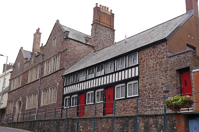
In Wellbrooke St there are Waldron's Almshouses with their adjoining chapel. They date from 1590 and were restored in 1987 (the chapel in 1990). The founder, Thomas Waldron, was a merchant. This area of the town, West Exe, was a centre for weaving and spinning from the early 16th century

Not far away is Heathcoat's Lace factory, founded by John Heathcote in 1816. By 1822 it was employing a staggering 1500 hundred men and it is still the town's largest employer. The original factory burned down in 1936, but was speedily reconstructed. The building on the right is the factory school of 1843, now the factory shop. I had a nice chat with the former Chief Engineer who happened to pass by as I was taking my photo.


Now back across the Exe and left into St Peter's St where a second set of almshouses, Slee's, founded by George Slee in 1610 for six single women. The first floor gallery was originally open.


On the left of the almshouses is the Great House of St George, constructed 1603-14 for George Slee apparently after a substantial fire of 1598 which destroyed much of the town.

At the end of the street is St Peter's church, a "gorgeous display of civic pride (and ostentatiousness)" [Pevsner] and dating from the early 16th century. The other side of the church has an imposing porch, but this side offered more favourable light.


Next to the church is the Castle, parts of which date from the late 13th and early 14th centuries.


There are more (former) almshouses in nearby Barrington St. The plaque reveals that this was "Blagdon's Charity. Destroyed by Fire and rebuilt 1833."


I now doubled back for a look at the Pannier Market of 1830. I liked the delicate iron columns.


Nearby, in Gold St, is the former Corn Market of 1732 with more imposing columns.

The final main sight, further down Gold St was Greenway's Almshouses, which like Waldron's have an attached chapel. They were founded in 1529. The stonework seems to have been renovated quite recently.There are two further parallel ranges behind dating from 1839 and 1889.


Beyond the end of Gold St, in Station Road, is the Clock Tower. I thought it might be one of the many clocks erected in commemoration of one or other of Queen Victoria's Jubilees, but it dates in fact from 1907.


Conditions: grey, cool, threat of rain.

Distance: about two miles.

Rating: four stars.

Wednesday, 15 June 2016

Passy Plaine-Joux

Passy Plaine-Joux

Still in the Alps and today's weather shows a massive improvement. We cross the valley from St Gervais and climb up to Passy Plaine-Joux at 1600m. Looking back across the valley we can see the pointed summit of Mont Joly at 2525m.

This is a well-known paragliding launch point and here is the spectacular view down into the valley from the edge of the launch zone.


With out backs to the valley we walk back past the car park and uphill towards the rocky massif behind.


Almost immediately I spot an unfamiliar Blue butterfly. I wasn't quick enough to get a picture and off it flew. A hopeful sign though.

Soon afterwards, the first new wildflower of the day presented itself: it seems to be some sort of vetch, but I haven't been able to identify it. A beautiful colour though.


Then we started to see a lot of this yellow flower, Field Mustard (Sinapsis arvensis).


As we continued uphill I thought I had found several examples of another butterfly, perhaps some sort of Checkered Skipper. My butterfly book established that it wasn't - it seems instead to be a moth, the Latticed Heath, or some continental variant of it.


Also flying in the same locality was another creature which was more obviously a moth, a Burnet Companion.


And another orchid to join those we saw yesterday at Le Bettex. I think this is a Military Orchid.


We were gradually getting nearer to the massif, which dramatically loomed over us.


A bit further on we heard the sound of a rock fall and could see some small debris coming over the edge of the massif. We were glad we were well out of the way.

The flowers were starting to become thinner on the ground, but this attractrive red flower stood out. Sadly, I have not been able to identify it.


There was a lovely view back over the winding track with a couple of other walkers kindly providing a sense of scale.


Finally, with the cloud growing and the temperature falling I spotted this pretty Matted Globularia (Globularia cordifolia).


It remained only to retrace our steps. Here is a final view of Mont Joly.


Conditions: clear and bright at first, becoming cloudier.

Distance:a couple of miles, but 1500m of ascent.

Rating: four stars.