Thursday, 28 January 2016

South West London

Sir William Powell's Almshouses, Fulham

A beautiful day for once and I decide to pursue my interest in almshouses with a Tube-assisted walk in South West London, starting from Putney Bridge tube station. Almost opposite is the church of All Saints. It has a handsome 14th century tower, but the rest of the church, abutting awkwardly against it, is late Victorian, by Sir Arthur Blomfield.


Behind the church, in Church Gate are Sir William Powell's Almshouses. They were originally founded in 1680, but were rebuilt here in 1869 by the architect John P Seddon. As the photo above shows, the site was small and constricting, but Seddon did a great job with the picturesque composition, high pitched roof and dormer windows. Pevsner (writing in 1952) says that these almshouses "should be carefully marked down for preservation". And happily they have been. 
The second picture shows the gable end and a tower apparently containing a staircase, adorned with figures of Faith, Hope and Charity.


At this point I decided to head across Putney Bridge in search of a second set of almshouses. But first, on the far side was another interesting church, St Mary's. Like its sister on the other bank this too had an old tower (15th century, with a nice sundial) and an incongruous nave, this time of 1836.


Round the corner in Putney Bridge Road, were Sir Abraham Dawes' Almshouses. These were originally founded in 1648 and rebuilt here, more humbly than the Powell ones, in 1854.


Returning to the Fulham side of the river, I decided to follow a sign to Fulham Palace - I didn't know there was one. You follow the river bank and then turn right to find this lovely entrance courtyard. This part dates back to the early 16th century. It turns out that it was country seat and later the Palace of the Bishops of London, from at least the 11th century up to 1975. It is still owned by the Church of England but managed by a Trust and the local authority.


The rear elevation is very different, late 18th century, with a red brick chapel by William Butterfield over to the left. I didn't go in, but it was a delightful surprise.


For the second part of my walk I took the Tube to Vauxhall. From there I walked South Lambeth Road to Fentiman Road, where I found Sir Noel de Caron's Almshouses. Like the others, these were founded in the 17th century (1618) and rebuilt in a new location in Victorian times (1854). De Caron was a long-serving Dutch ambassador to England.


I had one further target in mind and walked back along South Lambeth Road and along Kennington Lane and then Tyers St. This offered both a City Farm with donkeys and unusually clear view of the MI6 building designed by Terry Farrell.


My destination was Woodstock Court in nearby Newburn Street, set within a massive area of public housing dating mainly from the 1930s. This development dates from 1914 and was built by Prince Edward, Prince of Wales, for old tenants of the Duchy of Cornwall.


Conditions: clear and sunny!

Distance: I walked about 5 miles.

Rating: four stars. Partly what I expected, plus some nice surprises.

Saturday, 16 January 2016

Shell Bay and Studland Bay

Mouth of Poole Harbour

We did this walk on New Year's Day in the howling wind and rain. It was bracing and satisfying, but not much fun. Today offers a much nicer prospect to do it again. It is also the first stage of the South West Coast Path which we did on 25 January 2011. The really striking thing is how few other people were on the beach that day.

We took the Chain Ferry across the mouth of Poole Harbour, marked in the National Trust car park and headed past the wooden and blue metal signs marking the start of the wonderful Coast Path. Five years on, we have walked 500 miles along the coast path and have reached Bude. It is still hard to believe.


There is a sort of lagoon at the back of the beach and the sand patterns in the shallow water looked a bit like the pictures you sometimes see of the human brain.


Further along, there was a lovely view from the dunes across to the other side of the harbour mouth.


Soon we saw the first of the Sanderlings that we first noticed on New Year's Day. These hyperactive little waders have a wonderful way of running sideways in the sand at the edge of the water.


After we turned the corner into Studland Bay there was a steady stream of people waking along the beach, very many of them accompanied by their dogs.


The sun was in the wrong place for this picture towards Old Harry Rocks - more or less straight ahead - but it was still a nice view with the waves rolling in.


The view looking back was brighter, with the sun behind us, but there was still a steady stream of people walking on both directions. This picture came closer than the previous one to the style of Boudin, who painted so many views of people on the beaches of Normandy. They were much more formally dressed of course with their top hats, parasols and crinolines.


Eventually we reached the welcoming National Trust cafe at Knoll Beach and had a refreshing drink before heading back. I couldn't resist another view of Old Harry Rocks across the very calm sea.


In the latter part of the walk back we followed a path along the top of the dunes instead of walking along the shoreline. A steady two-way flow continued however.


Conditions: bright at first, becoming cloudier. Cool.

Map: Explorer OL15 (Purbeck and South Dorset).

Distance: about 5 miles.

Rating: four stars. A delightful walk.


Friday, 15 January 2016

Horsebridge and King's Somborne

Horsebridge Mill

This very pleasant walk starts at the hamlet of Horsebridge. You pass the handsome early 19th century mill and turn right along the Test Way alongside the shallow, fast flowing river Test. The path here follows the route of a dismantled railway. After about three-quarters of a mile you turn right onto the Clarendon Way to soon reach a road high above Kings Somborne. The village sits at the bottom of a valley.

You follow a field-edge path down to the village where you turn right to reach the church of St Peter and St Paul. The church is 13th century, but as is so often the case, much of what you now see is the result of a Victorian restoration. Inside there are some old brasses and a monument to a 14th century vicar.


We headed up church lane and were slightly surprised to find a vineyard on the right: Garlick Lane Vineyard, part of Somborne Valley Vineyards.


At the top of the hill the route bears left and passes a rather poignant monument to four German airmen shot down in 1940. Out walk book explains that the pilot, Bob Doe, who shot them down as his fifth kill (giving him the status of a "ace') went to the scene of the crash and was sicked by the scene of his triumph. He carried on fighting but never again went sightseeing. As an addendum to this tale, the small metal plate at the bottom of the monument gives the names of the Germans, discovered at some later date. From Wikipedia I learned that Doe shot down another 11 German planes and lived to be 89.


Soon after this the route turns left and follows the edge of a gallop, part of the equestrian centre.


This gives way to a field-edge path which descends gradually into King's Somborne. We returned to centre for lunch at the very pleasant Crown Inn, full of locals who were doing the same.


Now it past the church again then immediately right past the school, with a large grassy area on the left which is said to have been the site of John of Gaunt's Palace. This may have the same status as the numerous sites of "King John's Hunting Lodge" - i.e. a myth.

After crossing a playing field and a road, a narrow path running behind and sometimes through gardens led back to Horsebridge. This was a disappointing end to the walk.

On returning to Horsebridge we went to see the restored Southern Railway station, now a private house. The one angle with a reasonable view was looking straight into the sun, but I quite enjoyed this view through the hedge of an old coach.


Conditions: bright and sunny, cool.

Map: Explorer 131 (Romsey, Andover & Test Valley).

Distance: 6 miles.

From: 50 walks in Hampshire and Isle of Wight (AA).

Rating: three and a half stars.

Sunday, 10 January 2016

London: Clerkenwell

The Charterhouse

It was too wet and muddy to walk in the country, so we decided on another walk in London from the excellent London's Hidden Walks (vol 2) by Stephen Millar. We weren't entirely sure where Clerkenwell was, but it turns out to be the area between Barbican and Farringdon. Starting from Barbican tube station you walk through Charterhouse Square to reach the Charterhouse, once a medieval hospital, then an almshouse and school and finally, from 1872, only an almshouse.

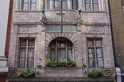
I already knew about the Charterhouse, but a short distance away along Charterhouse St, was a wonderful surprise: the art nouveau Fox and Anchor pub dating from the 1890s. We would have gone in to investigate further had it been open ...


Now across the road and through the centre of Smithfield meat market to West Smithfield, a pleasant sort of square, with some nice eateries - although it was once apparently a place of public execution (William Wallace, to whom there is a monument bedecked with Saltires, was one such unfortunate.) Tucked away in the corner is the hidden gem of St Bartolomew the Great, the "finest Norman church ion London". A service was underway, so we couldn't go in, but there are some nice photos in the City West walk I did a couple of years ago.


St Bart's hospital is around the corner and, unusually, it has a church inside its boundary, St Bartholomew the Less. Its tower can be seen in the photo below behind Henry VIII's gate, the main entrance to the hospital.


Coming back through Smithfield, we were struck by the beauty of the iron arches over the road.


Now the route heads north and we lost our way momentarily, but this did lead us past this intriguing house in Peter's Lane.


Going along St John's St we came on another surprise, the medieval St John's gate, the surviving part of the Priory of the Knights of St John of Jerusalem (or Knights Hospitaller, founded in 1099). The second surprise was that was site has been owned since 1872 by the British Order of St John, founders of the St John Ambulance Brigade, which is still headquartered there.


Soon after this we were in Clerkenwell Green, with the 18th century St James's church off to one side.


At the end of Clerkenwell Green there is a housing development by the Peabody Trust and nearby the Horseshoe pub, a cosy example from the early 19th century.


Just round the corner is the former Hugh Myddleton school, now converted into apartments. Our route takes us past the front and round to the back where there were three entrances: Boys, Girls & Infants, and Special Girls. What were Special Girls? Was that good or bad?


Soon we pass through Exmouth Market and and turn left into Farringdon Rd, passing the Mount Pleasant Sorting Office and later the Coach and Horses pub in Herbal Hill which runs parallel. In the road outside the pub is a grille under which runs the River Fleet, hidden underground since the mid-19th century.

Off to the left there is a glimpse of this wonderful house, Abbots Court, in Farringdon Place. I can't find out anything about its history.


And back in Farringdon Road is this Victorian gem in the style of a Venatian palazzo. Again, I would love to know more.

Returning now to the route, we walked further along Herbal Hill and turned right into Clerkenwell Road to see the wonderful Italian church founded in 1853. This area was home to many Italian immigrants in the 1850s and clearly still remains an Italian enclave: it was noticeable how many people we heard in the streets nearby speaking Italian.


Finally, we walked through Hatton Garden, with many jewellery shops open even on a Sunday afternoon, to pass the hidden Ye Olde Mitre Tavern, dating from 1546, and reach Ely Place. Here stood Ely House, the grand London residence of the Bishops of that town. The church of St Etheldra, dating from 1290, is the only surviving part of Ely House.


From here, it was a short walk to Farringdon Tube station.

Conditions: cold but sunny.

Distance: about 3 miles.

Rating: Four stars.