Tuesday, 31 March 2015

Midhurst

The ruins of Cowdray

Today a "town and country" walk starting in Midhurst with my friend Merv. We parked in North St on the northern edge of the town and headed across the main road, past the former Grammar School, to the new South Downs Visitor Centre where we were delighted to find the excellent Town Trail leaflet. I immediately went just a little further up North St to photograph Ognell's Almshouses. The twin plaques reveal that they were erected in 1578 and rebuilt in 1840.


We made a loop around Lambert's Lane a rejoined North Street nearer the town centre, noticing some fine Georgian buildings such as the Clock House.


Some apparently Georgian buildings were in fact medieval ones which had been refronted, sometimes quite blatently. We saw one with a Georgian facade on the main street and half-timbering along the side.

A bit further on we saw this wonderful art deco shop front. I couldn't take the whole of it because a large white van pulled up as we were approaching.


We walked along the charming Duck Lane to find the other, unnamed, Almshouses in Bepton Road. They were originally 16th century, but were rebuilt in 1832.

Turning now into West Street, we enjoyed a lovely street scene with timber-clad and timber-framed houses.


On the right a mysterious plaque announced that "In 1811 The Commandery House of the Knights of St John stood here". We collected a leaflet about this is the Midhurst Museum, of which more in a moment. Apparently, the Knights of the Hospital of St John the Baptist at Jerusalem, to give them their full name, held property in Midhurst and had a chapel there. The Knights were suppressed by Henry VIII in 1540 and their lands were seized, the chapel later being demolished. The plaque and the doorway in which is located, were erected in 1811 by John Seymour, local antiquarian, but there is apparently no evidence of the existence of a Commandery.

At the end of West St we turned right into South St and looked back on a lovely view with the Spread Eagel Hotel on the left. The tower of St Mary Magdalen and St Denys can be seen to the right. It is of 13th century origin but has been subject to "too much restoration" (Pevsner). It is certainly rather  a jumble of disparate elements.


The Market Square stands in front of the church and on the right is the Old Market Hall dating back to 1571. "Indifferent" says Pevsner and it is not hard to agree.


We followed Church Hill into Knockhundred Row, admiring a mixture of half-timbered and Georgian buildings. The town Museum already mentioned is in Knockhundred Market and is a remarkably small one: a single room 8ft 6in square. A very helpful volunteer explained that the collection changes every week.

We were now nearly at the end of our town walk and I must just mention one other impression: we saw several houses with their woodwork painted a rather virulent shade of dark yellow and we spent some time trying to conjure explanations for this. Maybe somebody had bought too much and sold it off cheap to his friends? The house in the background on the right above is an example.

Now up Sheep Lane past St Ann's, the largest of the many Georgian houses and along a narrow lane to suddenly emerge in the country, at the bottom of St Ann's Hill.

This quiet wooded hill is now all that remains of the Norman castle built here not long after the Conquest. We walked round it and then down to follow a path by the River Rother which soon led us to the magnificent ruins of Cowdray. This view taken on an angle gives more a sense of the large scale of the house and a glimpse of the ruins of the chapel.


The house was started in 1492 and bought by Sir William FitzWilliam, later Earl of Southampton, in 1537. It was he who added the magnificent gatehouse. His half-brother, Sir Anthony Browne, took over in 1542 and made further additions. The house was sadly destroyed by fire in 1793. Pevsner adds that eight days later the last of the family was killed trying to shoot the Rhine Falls; this fulfilled a curse (Pevsner does not say by whom or why).

We followed a wide path to nearby Easebourne, once the site of an important Priory, now a house attached to the church. "A picturesque ramble" says Pevsner.


We were soon confronted by more dark yellow woodwork. This building is the (Cowdray) Estate Office and it finally dawned on us that the ubiquitous dark yellow is the Cowdray colour. 


After a very good pub lunch we headed on through the village and turned right to walk through teh outskirts of Cowdray Park. After passing Vining Farm, there was a pleasing view south towards the South Downs.


Soon after this there was great excitement as we saw our first butterfly of the year, a Comma.


This was quickly followed by a Small Heath as we walked through classic country house parkland - landscaped, inevitably, by Capability Brown. Then across the golf course, the A272 road and beside the massive Polo field to return to Easebourne and thence past Cowdray again and back to the car park.

Conditions: sunny, but very windy.

Distance: about 6.5 miles.

Map: Explorer 133 (Haslemere & Petersfield).

Rating: four stars. A delightful small town with a wonderful ruined castle nearby.


Saturday, 28 March 2015

Godrevy Point to Portreath (South West Coast Path 69)

Seals in Mutton Cove near Godrevy Point

We picked up the Coast Path at Godrevy Point and headed on along the high (say 60m) cliffs. We noticed that a section of the cliff edge had a wooden barrier. On it were the words "Please speak only in whispers. Any sudden movement or noise can disturb the seals." Seals? We looked down and there stretched out across the sandy beach of Mutton Cove were maybe 70 Grey Seals.

We have had a few glimpses of Grey Seals at other points on the Coast Path, but to see such a large group was a real joy. They were mostly motionless, but every so often one would move awkwardly across the sand. These two seemed to be engaged in foreplay.


Soon the route entered a new environment: heathland. This is the view looking back over beautiful bright yellow broom towards Navax Point.


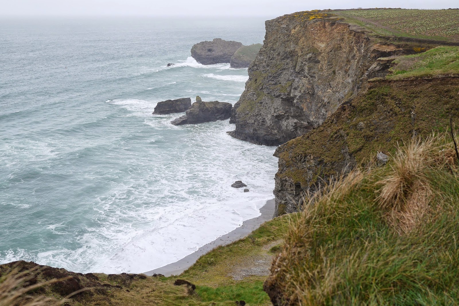
The coast gradually becomes more rocky.


But for the time being you continue on a cliff top path, now about 85 m above sea level, with a wide plateau inland. The coast stretches out ahead apparently promising more of the same.


Things change a bit further on with the Crane Islands in the foreground and the Samphire Islands beyond. In between lies a classic Coast Path descent to near sea level followed by a steep climb. You can see the gap in the cliff top on the right of the photo.


By now the rain which had been threatening for a while caught up with us as we made another descent and ascent at Carvannel Downs.

Finally we reached Western Hill overlooking Portreath and made our way down to the car park where we had left the car.


Conditions: not cold, but wet and grey.

Grading: Moderate.

Distance: 7.5 miles (distance now completed 415.0 miles).

Map: Explorer 102 (Land's End) and 104 (Redruth and St Agnes).

Rating: four stars.

Friday, 27 March 2015

Hayle to Godrevy Point (South West Coast Path 68)

We picked up the Coast Path again in Hayle and crossed a bridge to head along the North Quay. Behind us was the rather lovely church of St Elwyn. It dates from 1886-8 and was the work of J D Sedding, the architect of Truro cathedral and of the restoration of St Uny, across the estuary. In front of the church was the delightful Church Hall of 1905, looking like a church itself.  I am describing this rather than presenting a photograph because it was already raining, in sharp contract to the lovely weather yesterday evening.

Once we were clear of the quay we passed through an area of holiday homes, some ramshackle and other quite imposing. This was Hayle Towans, a towan is a sand dune. The rather urban route continued into The Towans and then, more exotically, Mexico Towans.

At the end of Mexico Towans, the path follows the back of the enormous sandy beach through the sand downs, now un-named. It was hard going with constant ups and downs over often quite soft sand. There were numerous parallel paths and it was hard to be sure that you were on the right one - but perhaps it didn't really matter.

As we headed further north we began to notice a nice line in slate waymarks pointing the way ahead over the dunes. The rain had finally stopped so it was possible to take a photo.


After Gwithian Towans, the sandy Godrevy beach stretched out ahead, with various random walkers and kite fliers offered a bit of interest.


At the end of the beach you begin a more conventional section of coastal path which leads round to Godrevy Point. Just off the Point is Godrevy Island which houses a still operational lighthouse of 1858–1859.


At Godrevy Point we called it a day.

Conditions: not cold, but wet and grey.

Grading: Moderate.

Distance: 4.2 miles (distance now completed 407.5 miles).

Map: Explorer 102 (Land's End).

Rating: three and a half stars.

Thursday, 26 March 2015

Truro

Truro City Hall

We have made a lot of visits to Cornwall while walking the South West Coast Path, but never seen the county town, Truro (Truro became the seat of the new diocese of Cornwall in 1876 and was granted city status in 1877). It was time to end that omission. Internet research revealed a town trail "Footsteps around Truro" available from the tourist office so we decided to follow that. The tourist office is located in the City Hall an Italian Renaissance style building of 1846-7.

Turning right along Boscawen St immediately brings you to face the former Coinage Hall.


This had nothing to do with money but everything to do with tin - tin mining. Truro was one of the five Stannary Towns in Cornwall - towns where until 1838 tin was assayed for purity and taxed before it could be sold or exported. (The others were Bodmin, Helston, Lostwithiel and Liskeard.) Coinage was the process of cutting a corner ("coin" in French) from the tin ingot.

I learn from Pevsner that the original Coinage Hall was demolished in 1840 - the current building dates from about 1850. It retains the name, but never carried out the function.

Bearing right of the Coinage Hall brings you into Princes St where the Mansion House, now rather appropriately an estate agents, is on the right. Pevsner regards this, and its near neighbour Princes House, as "the best town houses in Cornwall".


We found both a bit too severe, but further along the street we enjoyed this jolly pub, seemingly once a shop, with its fine windows and terracotta decoration.


Now along Quay St and into Duke St to then turn right down a narrow passage called Squeeze Cuts Alley. Truro has a number of these narrow passages which go by the name "opes". You emerge in St Mary's St opposite a small building which once housed the grammar school founded in 1549.


Towards the end of the street you are greeted by a dramatic view of the Cathedral. The extraordinary thing about this view is that an aisle of the former St Mary's church which previously occupied the site remains tucked in the south east corner (the rest of the church was demolished). This was at the insistence of the architect John Loughborough Pearson against the wishes of the first bishop of Truro, Edward White Benson. It is an unusual and charming feature.


We walked round to the magnificent west front to see head the towers which had only previously glimpsed from the main road on the edge of the city. Apart from its vertical emphasis, the other striking feature is the combination of grey Cornish granite and creamy bath stone.


Inside the principal impression is of calm, unity and harmony. The Cathedral took 30 years to build (started 1880, completed 1910). You can see that the choir is at a slight angle from the nave and this is the result of aligning it with the St Mary's aisle. It is just slightly disturbing.


St Mary's aisle is a delightfully airy space with a series of attractive bosses on the roof. They are a recent but very effective addition.


Outside to the right is the stately facade former Assembly Rooms of 1780, another reminder of Truro's Georgian heyday.


We walked along Pydar street past the substantial Victorian Library in search of some almshouses which I had read were there. The entry in Brian Howson's invaluable book, Almshouses, describes them as having inscriptions but being "otherwise unrecognisable as almshouses". This bank building with its low roofline and central pediment seemed the best fit with his 1631 date. I couldn't find any inscriptions though.


Pydar Mews brought us to Castle St where the modern Court buildings are to be found on a site that once home to a Norman castle. They date from 1986-8 and are the work of Evans and Shalev. Pevsner describes the work as of "the highest calibre in concept, architectural composition and immaculately controlled detail". We were ready to be impressed, but overall our feeling was that the building was too low-rise and suggestive more of a holiday hotel.


River St now brought is to Victoria Square at the opposite end of Boscawen St to where we started. Opposite, but even then not immediately visible, was a hidden gem, Walsingham Place. A curving terrace built in 1837 by Edmund Turner and John Ferris. The left hand side is more dramatic and the imposing entrances feature wonderful carvings of lions' heads.


At the end we went through the pleasant Lemon St Market into the Georgian Lemon Street, with a fine collection of late Georgian houses (it was built in 1801).


At the bottom is Lemon Quay where the Hall for Cornwall backs onto the City Hall. We quite liked the pub next door.


Conditions: a beautiful sunny day.

Distance: about 2 miles.

Rating: four stars. A delightful city.

St Ives to Hayle (South West Coast Path 67)

Porthminster Beach, St Ives

It's the start of of our annual progression along the South West Coast Path and we pick up the route by St Ives station, overlooking the beautiful Porthminster Beach. The path runs above the beach and then climbs further towards Porthminster Point. As you progress St Ives harbour opens itself up to view.


Beyond the point lies the equally sandy Carbis Bay.


You descend to just behind the beach and climb again to emerge overlooking Port Kidney Sands at the mouth of the Hayle River.


The path follows the dunes at the back of this vast sandy area and turns inland to follow the estuary. The tower of St Uny's church at Lelant dominates the view. According to Pevsner, Lelant was an important sea port in medieval times. The church is originally Norman, but mainly 15th century with late Victorian renovation by J D Sedding, the architect of Truro Cathedral.


Soon there is a good view across the estuary towards Hayle.


After the church the route becomes more suburban as you pass through new housing developments and then follow the road around the edge of the wide estuary into the town of Hayle. The last couple of miles are a bit boring to be honest.

Conditions: beautiful late afternoon sunshine.

Distance: 6.1 miles (distance now completed 403.3 miles).

Map: Explorer 102 (Land's End).

Grading: Easy.

Rating: three and a half stars.

Wednesday, 18 March 2015

Devizes and Caen Hill locks

The Market Square

Today looked to be the only bright day this week and so I decided on an outing. I fancied a town walk, but with a bit of country as well. I found this delightful walk on the AA website. It starts from the car park by the Kennet and Avon canal in Devizes.

You walk down Wharf Street and turn right into New Park St to soon reach Brownston House,which Pevsner described as "the best house in Devizes".


Next door is St Mary's church, Norman, but rebuilt in the 15th century.


The route leads into Monday Market Street, where Great Porch House on the left claims the distinction of being the oldest in the town.


After continuing along the uninspiring Sheep St you turn right into Bridewell St, where the former bridewell can be seen on the right.


Turning right out of Bridewell St into Long St, you pass the Wiltshire Heritage Museum where a pound buys you the excellent descriptive booklet for the Town Trail.

Soon, on the left, is the town's major church, St John's, another Norman foundation. This time it is more obvious with the great crossing tower. As ever, there are 15th century and 19th century rebuildings.


Over in the far corner of the churchyard is the Sexton's House, which the blue plaque describes as former almshouses - Pevsner adds a date of 1615


Behind the Sexton's House, Devizes Castle can be glimpsed. The Norman castle of 1080 was the origin of the town. The original castle, presumably of wood, was burnt down in 1113 and quickly rebuilt on a grand scale. Like other early medieval castles, e.g. Corfe, it was "slighted"(i.e rendered unusable) after the Civil War.


As I left the churchyard to go into St John's Alley I was struck by this attractive group of buildings.


I was convinced that the stone cottages on the right must be former almshouses and when I saw the name God's House I was even more persuaded. Pevsner confirms that they are the former New Almshouses of about 1842, altered in 1895.

At the end of the alley, you pass the Town Hall of 1806 and further on along St John's St, over to the right, I enjoyed this wonderful facade.


On the corner was the handsome Old Town Hall of 1752. I preferred it to the new Town Hall, built just over 50 years later.


The Market Place now opens up before you with the Corn Exchange (1857) on the left and the Market Cross (1814) to the right. The Market Place is a vast space, the site of a market since the 14th century, surrounded by attractive houses.

You leave it by Northgate St, with the imposing presence of Wadworth's Brewery (1885) at the end.


Continuing past the brewery you reach the Kennet and Avon canal where you turn left to follow the tow path towards the celebrated Caen Hill locks. The path descends gently past a couple of locks and then you gradually realise that you are on the edge of a plateau.


The descent of the hill is about three quarters of a mile and covers 16 locks in remarkably close proximity to each other. Each lock has a large sideways-extended "pound", a pond to the uninitiated, to store the water needed to operate them.


This is the front-on view from the bottom. This section of the canal was designed by John Rennie and it was completed in 1810.


From the bottom, you simply retrace your steps to Northgate Street and continue along the tow path back to the Quay.

Conditions: bright and sunny, feeling quite warm in the sun.

Distance: 4.2 miles.

From: the AA website.

Rating: four stars. A lovely day out.