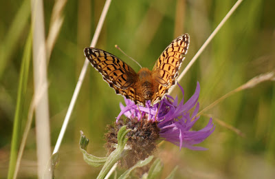
Wednesday, 24 July 2013

Aston Rowant


Another butterfly walk, chosen like other recent ones from  David Newland's wonderful Where to see butterflies in Britain. Today's target species was the Chalkhill Blue, which I have never seen.

There are two paths from the car park at Aston Rowant. I look the left hand one, closest to the motorway and followed a descending route through woodland, with mounting traffic noise - not awfully auspicious. After about half a mile however you emerge at the bottom of Beacon Hill. I looked around and immediately saw my first Chalkhill Blue!

I then made a very slow movement along the sunken track ending at a wooden stair rail. I then lopped back along a higher path and came round again. The view back shows the lower hillside on the left and the point where the M40 cuts through the Chilterns is on the far right.


There were just loads of Chalkhill Blues, especially on the clumps of Large Thyme, but on other plants to. They were not too bothered by my presence and just continued fidgeting around on the flowers, sometimes disturbed by the strong breeze or by other insects. The characteristic and distinctive silvery blue was very obvious and it was instructive to see how variable the back markings on the wing margins actually were. The hind wings consistently had black dots surrounded by white, but the fore wings sometimes had clear black dots on a dark ground, sometime fuzzy dots and sometimes no real dots at all, just a black edge.


The undersides were actually more of a creamy colour than photos suggest and the coloured dots varied between pale orange and quite red.


The early clump of Large Thyme was also host to this beautiful Small Copper ...


... and a spectacularly bright Small Tortoiseshell, as well as innumerable Small Skippers.


Later, I had a very nice shot of a Large Skipper.


There were also legions of Meadow Browns, a few Small Heaths, some Marbled Whites, Large and Small Whites, a Comma and a Red Admiral. So quite a good haul.

The hillside flowers included this unusual Dwarf Thistle ...


... some Clustered Bellflowers ...


... and this lovely Pyramidal orchid.


After a thorough exploration of the lower hillside, I walked on along a climbing track and turned right to reach the path at the top of the hill, just below the tree line, and followed this back to the car park. It was noticeably windier up here and there were many fewer butterflies.

Conditions: hot and sunny again.

Map: Explorer 171 (Chiltern Hills West).

Distance: about 2 miles.

Rating: four stars.

Sunday, 21 July 2013

Pamber Forest

A Gatekeeper

It seems that the sunny weather is about to give way to thunder storms, so I thought I would have another butterfly walk before it was too late. Last week's butterfly walk at Prestbury Hill was a joy and I decided to go again to nearby Pamber Forest where I saw Silver-washed Fritillaries and White Admirals last year.

I parked on the edge of Tadley Common and walked along Pamber Heath Rd for a quarter of a mile, turned left into a gravel track and right to join the long straight path that diagonally crosses Pamber Forest. Almost immediately I saw my first Gatekeepers of the year, in the hedgerow, exactly where they should be, along with Meadow Browns, Ringlets, Large Whites and an unexpected Marbled White.

Within minutes of entering the wide sunny forest drive I had seen Large and Small Skippers and it wasn't long before the first Silver-washed Fritillaries and a lone White Admiral appeared. It gradually became crystal clear that every open sunny patch on the left of the path would have these, so long as there were some brambles as well. There was of course the frustration, that neither would roost for long enough to allow a decent photo.

The largest number of sightings occurred once I was about three quarters of the way through the Forest and the wide gravel track had narrowed to a small path. Here at last I got a nice clear shot of a Silver-washed Fritillary with wings wide open.


And in a nearby bush, an equally clear shot of the underwings, with the streaky silver wash which is the distinguishing feature of the species.


The White Admirals were more cooperative too, but this time I did not get to see the richly patterned underwings.


To add to the fun, I number of Brimstones could be seen taking nectar from thistles: the proboscis (tongue) is clearly visible in this picture, at least if you click to enlarge it.


And a Peacock added its iridescent colours on a bracken frond. A couple of Commas were flying around too and some Green-veined Whites.


To complete the picture, I managed - in the less deeply wooded section - a nice Large Skipper ...


... and a Small Skipper.


Distance: just under 4 miles.

Conditions: hot and sunny.

Map: Explorer 159 (Reading, Wokingham and Pangbourne).

Rating: four stars. Happily lost in butterflies!

Thursday, 18 July 2013

Prestbury Hill

The entrance to the Bill Smyllie reserve

En route to visit one of my daughters in Gloucester, I decided to continue my butterfly sites project: I have been recently to Martin Down and Noar Hill. David Newlands's excellent Where to see butterflies in England lists only this in Gloucestershire, so it was an automatic choice. It is run by Butterfly Conservation and the information panel you can see in the photo is reproduced here. The precise location is on the Cleeve Hill escarpment, overlooking Cheltenham Racecourse, at map reference S0 993 244. I had already walked through the bottom of the reserve as part of the

The main part of the is a grassy limestone hill known as the Bill Smyllie Reserve. My "walk" consisted of a slow meander down the hill and a slightly quicker one back up again. I was especially hoping to see some Dark Green Fritillaries. I knew within seconds of parking the car, even before I entered the reserve, that this was going to be a good day as I could immediately see lots of butterflies fluttering in and just above the long grass.

I saw my first Dark Green Fritillaries within moments and was struck by the massive number of Marbled Whites everywhere. It quickly became clear that there were also lots of Meadow Browns, Ringlets, Small Blues, Small Heaths and Skippers. I also saw just a couple of Large Whites, one of which seemed to be being chased away by a much smaller Marbled White.

I have read that Dark Green Fritillaries can be hard to photograph, as the males are constantly in flight and the females hide in the grass, so I was thrilled to quickly have this photo opportunity once i spotted a clump of Greater Knapweed.


Soon a second DGF offered me a clear view of its upper wings.


And another provided a good view of the green-washed underwings which give it its name.


There were any amount of chances to capture the beautiful patterning of the underwings of the Marbled White. This is a female.


And this, rather more unusual, sight of the butterfly with its wings open photographed from below. This is the darker male.


Later I became aware of a number of Six Spot Burnet Moths, mostly to be found, like this one, on Scabious.


Towards the bottom of the hill, there were some scattered orchids and this exquisite Yellow Wort.


Distance: about a mile!

Conditions: sunny and hot.

Map: Explorer 179 (Gloucester, Cheltenham and Stroud).

Rating: four and half stars.

Wednesday, 10 July 2013

Cerne Abbas and Minterne Magna


Abbey Farm, Cerne Abbas

Today's brief from my daughter and son-in-law, who are staying with us in Poole, was for a demanding walk, without vertiginous sea cliffs. I thought the Cerne Valley would hit the spot.

We left the car at the Kettle Bridge picnic area on the edge of Cerne Abbas and walked along a path by the tiny river Cerne to the village, emerging near to the abbey ruins. We wandered down Abbey Street to admire a lovely group of timber-framed cottages opposite the mainly 15th century church.


Then we walked back to the imposing Abbey Farm with the abbey ruins in its grounds. The great Benedictine Abbey was founded in 987, but destroyed in the Dissolution of the Monasteries in 1539. The main feature now is the impressive Gatehouse.


There is also a 15th century building known as the guest house. The walk route then leads through the graveyard, entered and left by arched gates.

We crossed an open grassy area and spotted our first butterflies: Meadow Brown, Ringlet, Small Tortoiseshell and Small Skipper. Now climbed some steps to reach the slope of Cerne Giant Hill. The path followed the contours below the famous chalk giant, of which more later. The hillside was covered in flowers, including lots of Pyramidal Orchids.


There were just loads of Ringlets now and a good number of Marbled Whites. We, erroneously, climbed the steep hillside to near the ridge, but at least we were rewarded with wonderful views across the Cerne valley.


We now walked across a series of field paths along the right (east) side of the valley, with views down the valley to the village of Minterne Magna.


The ridge turns to the northwest and soon Minterne House is the dominant feature.


 The house dates only from 1904-06 and is the work of Leonard Stokes for Lord Digby. In Pevsner's view, it is a "beautifully sophisticated design". Unfortunately, it is not open to the public, although the gardens are.

We shortened the walk by coming down from the ridge into Minterne Magna, passing through the park of Minterne House and then coming to St Andrew's church.


It is a mixture of 15th century, early 17th century and early 19th century work - "a rare assembly", says Pevsner. The overall effect is quite harmonious.

Having descended from one ridge, the next stage inevitably was quite a steep climb towards the ridge on the other side of the valley, followed by a slow descent to the valley bottom through woodland - which we weren't really expecting.

Emerging from the woods, we walked along a tarmac track along the valley bottom to reach Minterne Parva. There are only a few cottages, a manor house and a church: a rather classic combination.


Just along the lane we saw a pair of Ringlets mating, which allowed a nice, if slightly blurred, photo.


The lane eventually joins the main road and soon you have a great view of Cerne Giant Hill ...


... and then of the Giant himself, who to be honest, was not really looking his best today, although his masculinity was reassuringly to the fore.


From: Dorset Walks (Pathfinder Guides).

Map: Explorer 117 (Cerne Abbas and Bere Regis).

Conditions: sunny and hot.

Distance: 5.5 miles.

Rating: four stars.

Wednesday, 3 July 2013

The Oxfordshire Way: A review


Background

The Oxfordshire Way runs for 68.25 miles from Bourton-on-the-Water to Henley-on-Thames, from the Cotswolds to the Chilterns. The Path was developed by the Oxfordshire Branch of the Council for the Protection of Rural England (CPRE) as far back as 1978 and later adopted by the County Council. We used The Oxfordshire Way. A walker's guide published by the County Council in 1993 as a resource and found it to be very useful and informative and still largely accurate. There was just one map where the route was wrongly marked, but we soon figured it out. The signposting was pretty good too.

We did the Oxfordshire Way with our friends Merv and Pud and we started by doing the short Windrush Way in two sections from Winchcombe to Hawling and from Hawling to Bourton as a sort of warm-up and to link it to our previous venture, the Cotswold Way. We started on 1 April 2012 and have only just finished. Some personal factors resulted in the odd cancellation of a planned leg, but the weather played a big part - there is just no fun in setting out on a walk when you know it is already pouring down with rain.

Impressions

The walk has three distinct components: the section up to about Charlbury (our third stage) still feels like the Cotswolds, then there is the main body of the path which arcs across Oxfordshire, north of Oxford, which we found surprisingly flat. After that the final two stages through the Chilterns came as a bit of a relief. Overall, then it was an easier walk that the Cotswold Way, but less dramatic and with less stunning scenery.

It was striking how many country house parks we walked through. Blenheim was by the far the greatest of them, but there were several other pleasant, mainly Georgian, houses at places like Kirtlington, Rycote and Waterperry.

Otmoor is an unusual area and important type of habitat. Our guide described the low lying flat moorland as "often boggy". This turned out to be something of an understatement - totally saturated would have been more accurate and just after Waterperry there was a section which could only be described as flooded, which gave us some concern about whether we would be able to get through at all.

We found a good number of excellent pubs to have lunch on afterwards, notably the Kings Head at Bledington, the Crown at Pishill and the Angel on the Bridge at Henley

And finally every walk had its share of Kites, many swooping low to show off their fine colours. At one point we saw five in the air at once. To think that this species was once endangered and had to be re-introduced. "As common as sparrows", somebody said - but of course sparrows are becoming much rarer in this part of the country, so this is a rather two-edge comment.

All in all a most enjoyable walk that did not quite reach the heights of the Cotswold Way, both literally and metaphorically. Would we recommend it? It is an excellent means to get an overall feel for what Oxfordshire is like. The only problem is that it turns out that some parts are perhaps a bit dull.

We now plan to start the Ridgeway this autumn.

Stages

1 Bourton-on-the-Water to Foxholes

2 Foxholes to Grove Lane

3 Grove Lane to Littleworth Farm

4 Littleworth Farm to Kirtlington

5 Kirtlington to Islip

6 Islip to Menmarch Guide Post

7 Menmarch Guide Post to Albury

8 Albury to Wheatfield

 9 Wheatfield to Pishill

10 Pishill to Henley

Monday, 1 July 2013

Wareham and Swineham Point

 Wareham Quay

We were looking for a short local walk, ending with a pub lunch, to take our friends Sarah and Alan on. I came up with this delightful walk around Wareham in Pocket Pub Walks in Dorset by Nigel Vile (Countryside Books). We like Wareham, having previously walked around the town, from Wareham to Stoborough and at nearby Arne.

We started at Wareham's charming quay and walked towards Lady St Mary church.


The church is of Saxon origin, but the Saxon nave was demolished in 1842 apparently because the roof leaked. Much of what you see now is Victorian, but the tower is 15th century and other parts are older.

We skirted the churchyard and soon found ourselves on the grassy Saxon walls. They date from the 9th century and surround the town on three sides.


At about this point we left the walls and headed right through woodland to arrive at the open grassland which borders the tiny river Piddle. This is the view looking back as we turned right towards Swineham Point Reserve.


After passing a flooded gravel pit along a reed-lined path, we reached Swineham point and were offered a choice of paths back to Wareham: a winding one following the course of the River Frome (2.5m), or a more direct and straighter one (1m). We were feeling in need of lunch and so we chose the latter. Our walk book is in error here as it describes the river route as 1.5 miles.

Along the way back we suddenly saw a lot of this purple-pink flower in the hedgerow. The leaves indicated that it was obviously some sort of vetch, but which? The answer turns out to be Tufted Vetch. Very striking.

A little further on and I managed to get a decent picture of a Common Blue Damselfly. We had seen lots of them, but this was the first one I noticed perching for any length. It let me get surprisingly close - this picture was taken with the macro lens I normally use for flowers.


We returned to the walls and then took a right to follow East St to the main cross roads and then South St down to the Quay. We had a pretty ordinary lunch in the Quay Inn. There was shock and horror when the Ploughman's Lunches arrived with sliced white bread. A request for granary bread instead produced .... sliced granary bread.

Conditions: pleasantly warm.

Distance: about 3 miles.

Map: Explorer OL15 (Purbeck and South Dorset).

Rating: Three and a half star.