Monday, 29 November 2010

Seven Springs to Birdlip (Cotwold Way 6)


We resumed our assault on the Cotswold Way with our friends Merv and Pud, picking up the route at Seven Springs - which despite its interesting-sounding name is essentially a lay-by for lorries on the A436.

We soon joined a farm road and climbed with fine views on the right towards Wistley Hill and the section of the Cotswold Way we walked last time (Ravensgate Hill and Lineover Wood). As the photo above shows, the landscape had a wintry hue.

We soon reached the Cotswold escarpment at Hartley Hill, where, as at Lineover Wood in the previous leg, there were fine views over Cheltenham.


 My shadow creates an odd - and unintended effect - on the frozen bench. Must watch out for that in future! The route then follows the Cotswold escarpment around Leckhampton Hill.


There were noticeably more people on this part of the walk, including a number of families with young children. We saw the first of several larches here, still boasting strong autumn colours.


Soon after this the route leaves the scarp for a while and follows a track and a small road to enter Barrow Piece plantation. You emerge from this into Crickley Hill country park with its 250 year old beech trees.

Soon you can follow the scarp again around the open edge of Crickley Hill. The visibility had declined by now and the photographic opportunities with it. This picture shows Crickley Hill looking back from Barrow Wake.


We descended from the Hill, crossed the busy A417 by the Air Balloon pub and climbed up to Barrow Wake, following a path below the level of the car park. This path soon entered woodland which led to a rocky promontory, The Peak. From here, we soon reached Birdlip.

Conditions: below freezing, hazy, some bits of blue sky.

Distance: 7.5 miles.

Rating: four stars.

An unusual experience

At one point, we stood aside to let a range rover past and the driver stopped and hailed us cheerily, commenting on how cold it was and saying that he would get his wife to put the kettle on a make us some tea. To our astonishment, further along he came roaring up behind us with a jug of tea, which he served us out of plastic cups. We had an interesting chat about the locality and the story behind his house. We were all surprised and delighted.

Monday, 22 November 2010

Salisbury

Salisbury Cathedral from the Cathedral Close

We met up with our friends Sally and Malcolm for this walk. We have been following a home-and-away principle, but this time we took a more radical approach and met up in Salisbury, a city which none of the four of us had ever visited. I found this excellent walk around the city on the AA website.

It begins conveniently enough at the Central car park. You walk along by the Avon tributary stream past a shopping centre to reach St Thomas's church. This is a delightful church of the early 15th century with a bell tower that was originally separate. We could not look inside as there was a service underway.

We turned left along Silver St to soon encounter the 15th century Poultry Cross, the one remaining of the original four market crosses.


Further along you reach the back of the Guildhall and we went round to the front in Market Square for a better look.

We were impressed with the size of the Market Square and were pleased to correctly guess the age of the Guildhall as late 18th century. In fact it dates from 1788-95 and was built following the destruction of its Elizabethan predecessor by fire.

Two right turns brought us into New Canal to visit the Odeon Cinema. A surprising choice for a walk in a historic city, but an absolute delight. Behind an extravagant late Victorian timber-framed facade lies the banqueting hall of John Halle, a wool merchant and four times mayor of Salisbury. The house was built in 1470-83 and was restored by AWN Pugin and the hall is all that remains. It has a fine fireplace, stained glass windows and an open timber roof. Just beyond it, you go up the stairs to have your ticket taken before you enter the cinema. Surreally wonderful!


We turned round, walked back along Milford St, past the Red Lion, with its charming courtyard, and then along Brown St and Trinity St to pass Trinity Hospital, almshouses. According to Pevsner, this was founded before 1379 and rebuilt in 1702. We could see through a window the small courtyard which leads to the chapel, but unfortunately the entrance door was locked.


A loop around brought us to the Joiners' Hall at the top of St Ann Street, described by Pevsner as "one of the most rewarding streets of Salisbury". He describes the Joiners' Hall as "best timber-framed house in Salisbury". It dates from about 1635.


The rest of the street contains a succession of handsome houses of various periods. At the end is St Ann's gate which leads into the Cathedral Close.


The immediate impression of the Close is of its great size, which allows the imposing Cathedral to stand in splendid isolation. It is instantly clear that the main body of the Cathedral possesses a great stylistic unity - and indeed it was all built over a 60 year period in the 13th century. The magnificent spire is clearly different, more elaborately decorated. It comes as no surprise to learn that it was added a hundred years later. At 404 ft, it is the tallest of any English cathedral. Ulm, in Germany, has the distinction of having the tallest spire of any church (530 ft) - and it was also the birthplace of Albert Einstein.

The uniformity of design is even clearer inside. The long nave with its high lancet windows and thin columns of Purbeck marble is a beautiful composition.


Outside there is a massive cloister, which Pevsner says was built as an after-thought. The lack of any surrounding buildings gives it an unusual character. The two Lebanon cedars are a wonderful centrepiece.


We then wandered round the close, admiring its mainly Georgian buildings. We left the Close by way of the North Gate, with the Matron's College - an almshouse for the widows of clergymen - on the right. It was established in 1682 and the building, says Pevsner, was quite possibly designed or approved by Wren.


North Gate leads to the High Street and from here we walked out, along a pleasant causeway across the water meadows, to the Old Mill at Harnham where we had lunch. This excursion enabled us to enjoy the view of the cathedral enjoyed by Constable.

On our return we enjoyed the Clock Tower of 1892, curiously derided by Pevsner as "a depressing Gothic erection in a position without distinction".


Conditions: cold.

Distance: about 3.5 miles.

Rating: four and a half stars. A wonderfully unspoiled city where nothing has been allowed to be built which would compete with the Cathedral. It would repay another visit.

Friday, 19 November 2010

Corfe Castle and the Purbeck Ridge

Corfe Castle

Another foray from our base in Poole. We parked at a lay-by just off the main road underneath the castle and walked up to the village proper to start the walk near St Edward's church. WE should have begun opposite the 18th century Greyhound pub, but in fact we walked round to the front of the church to see the fine 13th century tower with its impressive gargoyles (the rest of the church is Victorian (1859-60) by TH Wyatt in a matching style.

A benefit of this mistake was that we saw the tiny town hall of 1774, which boasts a plaque claiming to be the smallest town hall in England.


We decided to save a visit to the castle for another day and began the walk by going round the side of the castle mound and descending with it up on out right. The ruins of the Norman keep were clearly visible, as was the line of a later outer protective wall with various bastions. Corfe was a Royalist stronghold during the Civil War and the castle was deliberately shattered by explosives after it was finally captured by the Parliamentarians.


After crossing a lane and then the small river Corfe, the follows the Hardy Way heading upwards to join the Purbeck ridge at Knowle Hill. As it climbs, there are fine views back towards the castle (see above) and later the village, in this case with the smoke of a train on the Swanage railway line in the air above it.


As you walk along the ridge, there are fine views to the south toward another lower ridge, with the village of Church Knowle and its low mainly 13th century church in the valley below. Further on, by moving higher up the ridge views to the north become available: Wareham Forest, part of Hardy's Egdon Heath and Poole Harbour.


After a short dip, the route climbs Ridgeway Hill (168m) where there are further wonderful views towards the sea to the south: St Aldhelm's Head is hidden by the hill on the left.


This marks the edge of the ridge walk. You turn right and and right again to descend along a road through the pretty hamlet of East Creech. After a bit more road you enter Norden Wood, accurately described by our walk book as "exceptionally beautiful". The winding and undulating route also has scattered pools formed from one-time clay pits.


After a mile or so you emerge from the wood to cross a field towards the ridge and the turn left to follow the same line but part way up the slope. This section was the least pleasant for us because it was by now raining quite heavily.

However, the rain mercifully stopped as we emerged from woodland to this fine view of Corfe Castle across open fields.


From: Dorset Walks (Pathfinder Guides)

Map: Explorer OL15 (Purbeck and South Dorset).

Conditions: 10-12 degrees, sun, cloud and rain; wet underfoot.

Distance: 6 miles.

Rating: four and half stars. Great variety and fantastic views.


Sightings

We saw what we think may have been a Hobby hovering effortless at the edge of the ridge. More probably, it was a kestrel.

We also saw a single lone butterfly. It seemed to be a Small Skipper - but maybe it was my first sight of a Lulworth Skipper.

Wednesday, 10 November 2010

Sonning Common and Rotherfield Greys

Flowercroft Wood

A lovely autumn afternoon and I decided to take a short walk to try to relieve some stiffness. This walk starts in the centre of the sprawling village of Sonning Common. As I arrived, I was greeted by the almost obligatory kite circling above. You walk back along the main road and turn left to walk up past a pond and along another road before finally escaping into a field path across open country, with Flowercroft Wood ahead to the left.

You skirt the wood, climb a steep hill to reach a lane, where there are nice views towards the Chilterns to the east.


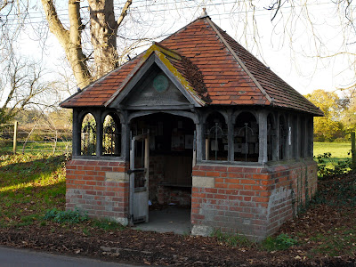
A series of field paths across very open country bring you to Rotherfield Greys, where you pass some old cottages and then notice one of the many structures built in the Thames Valley to commemorate Queen Victoria's Diamond Jubilee in 1897. This was has apparently been both a well-house and a bus stop.


Almost opposite is the church of St Nicholas. According to Pevsner, there are one or two Norman fragments: a round doorway can be seen on the left in the nave, for example, but the church was essentially rebuilt by Woodman in 1865. The north chapel (on the left in the photo) was built in 1605 by William Knollys, first earl of Banbury as a memorial chapel. (Now I can guess why there used to be a Great Knollys St in Reading.)


More fields, a small section of woodland and a path across a plantation, which then crosses a golf course, lead to the nearby village of Rotherfield Peppard, whose church also is Victorian with Norman fragments.

You now follow a steeply descending path field towards a delightful valley called Stony Bottom. On the way down I saw two pairs of kites circling away to the east. On the other side of the valley you climb through beech woods back to Sonning Common. Although most of the leaves now form a thick carpet on the floor, the view back through the trees towards the other side of the valley was still pleasing.


From: Rambling for pleasure around Reading (second series) by David Bounds for the East Berkshire Ramblers

Map: Explorer 171 (Chiltern Hill West).

Distance: 4.5 miles.

Conditions: bright, fresh, a bit muddy in places.

Rating: three stars.


Sightings

Apart from the kites, the only other wildlife interest came at the pond on the edge of Sonning Common. There were lots of mallards and a number of what, since my walk from Turlin Moor to Poole Quay, I can now confidently identify as Black Headed Gulls. The one oddity was this bird, which looks a bit like a mallard on steroids, but initial investigations suggested may be a Bean Goose.


I contacted the RSPB to find out. They identified it as a Khaki Campbell duck, a domestic type of Mallard, which had presumably escaped from captivity. My initial assessment was not so far out!

Sunday, 7 November 2010

Chichester

The East walls

The original plan was to see the cathedral, but we pestered Viv and Giles, with whom we were staying, to show us the walk around the city walls as well. We began in the South East Quadrant, which turned out to be one of the least impressive sections: just a path through a small garden.


We headed across town, past the impressive octagonal St John's chapel.


Apart from being a handsome building, it has a fascinating story. It was built in 1814 as a proprietary chapel: it was part of the Church of England, but was run as a commercial venture. The trustees had to raise enough money to pay a dividend to their investors and pay the minister's salary. It is no longer used as a place of religion.

We then passed St Pancas Church to follow the East walls. The first section was pleasant, but the walls became much more impressive once we reached the section that flanks Priory Park. To left was the handsome Guildhall.


But it looks like a church! And in fact it was once the church of a Franciscan friary founded in 1240. After the Dissolution of the Monasteries it was sold by Henry VIII to the city and became its Guildhall. It is now part of the Chichester museum.

A bit further on is a mound that was apparently once the site of a castle. Presumably health and safety concerns account for the barriers. The cathedral can be glimpsed in the background.


The North walls, the next section, also offer a nice promenade and the interesting array of houses, large and small, that back onto them provided us with plenty to discuss.


At the end of this section, we walked along East Street to see the fine Chichester Market Cross, which dates from 1501.


We then retraced our steps to have a look at the magnificent cathedral. The first thing you see is the separate campanile, free-standing in the Italian fashion. It dates from 1406.


The original cathedral was founded by St Wilfrid in Selsey, but the Normans built a new one here starting in 1076. It is difficult to take a photo of the cathedral which shows it as a whole: this one is from a corner of the cloister. A service was underway so we did not get to see the interior.


Emerging out of the cloister, we walked along the charming Vicars Close and emerged under an archway into the town centre again.


Conditions: sunny, fresh.

Distance: a couple of miles.

Rating: four stars.


Reflections

I found it surprising that Chichester does not make more its walls. There does not even seem to be a leaflet describing a walk around them or the sights you can see from them. Chichester District Council's web site contains only sketchy information and even admits that the signposting is poor. However, it does at least describe a Walls Project and promises improvements that will allow 2011 to be the celebratory year of the walls.

Saturday, 6 November 2010

Petworth Park

Petworth Park

We met up with our friends Viv and Giles for this lovely walk in Petworth Park. We started in the northernmost car park and headed across the lovely undulating parkland - created by Capability Brown between 1751 and 1764. Our first view of the Park is shown above.

After a while we noticed an increasing number of people in hunting garb riding across our route towards the house. This view, looking back, shows a couple of them.


We pondered what they might be hunting and concluded that they were drag hunting. Or maybe hunting in drag, cue general hilarity and unrepeatable jokes.

Once we reached the far hillside, this fine folly came into view.


A little further on there was a wonderful view across the park.


We now left the park and walked along the road into the village of Tillington. We enjoyed a notice on the outside of the Post Office offering to transact insurance and annuity business. When did that date from? The church of All Hallows, opposite, was mostly rebuilt and enlarged between 1807 and 1837. Its unusual Scots crown tower is distinctive.


We admired the pair of knightly - or perhaps kingly - gargoyles on either side of the main door.


After a further stretch along the road, we reached the main entrance to Petworth House. We walked up the main drive, past Capability Brown's fine lake.


And then studied the rear facade of the House itself across a vast lawn. The House dates from 1688 and was built, on the site of an earlier house, for Charles Seymour, 6th Duke of Somerset. It holds a fine and famous collection of paintings, but unfortunately for us had just closed for the winter.


There now followed a long diagonal stretch across the park, past an area where a large herd of deer had gathered, back to the car park. Petworth is famous for having the oldest and largest herd of fallow deer in the UK.


Cloudy with a threat of rain.

Distance: almost 5 miles.

Rating: four stars. We have walked in a few country house parks (Hatfield House, Claydon House, Audley End, Lyme Park ), but this was surely one of the finest.