Sunday, 28 March 2010

Hungerford and Standen Manor

St Lawrence's Church, Hungerford

We started this Sunday walk at Hungerford railway station, walked down to and across the High St and along a path to a quiet grassy square with the rather pleasing Croft Hall on the right.


A bit further on you come to St Lawrence's church of 1816. Pevsner calls it "large and uninspired", but this is harsh. It is well-proportioned in the style of a Cotswold wool church like those at Fairford or Bibury and has a most unusual apse end.

From here you walk under a railway bridge and leave the town by walking along Smitham Bridge Rd. After a while you turn left along a footpath and enter open country, walking across fields and through a copse to reach Standen Manor.


The Manor, a handsome building, dates from the early 18th century. From the front it has classic Georgian proportions, but from an angle, the unusual side of the right wing becomes apparent - seemingly a later addition.

Now the route heads east, with wide open views towards the North Hampshire Downs to the south and only a few small villages in between. The view back toward Hungerford is also quite appealing.


Reaching Inkpen Road you head back towards Hungerford, joining a path across fields at Sanham Green. We saw a kite circling not far above us. This path reaches the outskirts of the town and a footpath takes you to the top of the High St. Just for a moment the view evokes Burford and other Georgian market towns built mainly around one long street.


Conditions: cloudy, 10-11 degrees.

Distance: 4 miles.

From: Walks in the Kennet Valley and Beyond (West Berks Ramblers).

Map: Explorer 159 (Newbury and Hungerford).


Rating: three stars. Expanded our knowledge of Hungerford, but the inevitable price of starting at the railway station was walking through some drab parts of the town.


Flowers of the day

For most of the walk we were feeling rather disappointed, with only a few wild daffodils in sight. Why were there no Celandines like we saw last week in Llangybi? However when we reached the hamlet of Sanham Green we saw some Celandines at last and a little mixed clump of Common Chickweed and Common Field Speedwell.

Sunday, 21 March 2010

Llangybi

The White Hart

In Llangybi on family business, we did a second walk from the parish website - we did the other one last year. The walk begins at the White Hart pub, apparently the oldest dwelling in the village. We chose the longest option, the red walk of 4.5 miles. Rather wonderfully, the map was marked in green with the word "red" to keep us straight. Still, it was all perfectly clear.

You walk up Ton Road opposite and bear left into Fox's Lane. You are very quickly out of the village and soon enjoy lovely views over Cefn Hill to the west.


The views to the north-west are also very agreeable.


We looked down on Cefn Llech from the road. At Upper Cefn Carnau you turn north-west down a steep hill ...


... across a stream and a field and a few yards of road to pick up a track leading through Dale's Wood beside a stream to reach Craigwith House.

You skirt the house through parkland and after a short stretch of road enter Llangibby Park. Here you descend a steep wooded ravine.


At the lowest point, you swing right along a logging track to reach Parc Road which descends back to the pub in the village centre.

Map: Explorer 152 (Newport and Pontypool).

Conditions: bright, mild.

Distance: 4.5 miles.

Rating: four stars. Fantastic views in all directions.


Flower of the day

Increasing reassurance that spring is here. We saw the inevitable snowdrops and daffodils, but also some white violets and the first Celandine of the year.

Wednesday, 17 March 2010

Brimpsfield

Looking back along the valley to Caudle Green

En route for Gloucester again, I made small detour off the A417 to start this walk in Brimpsfield. You park at the Village hall and soon take a path towards the church. This passes the site of a former castle. The moat is still clearly visible as well as a mound inside it.


The castle was built in the 14th century, but its owner rebelled unsuccessfully against Edward II and was executed. The castle was "slighted" - put beyond military use - and over time the stone was appropriated for other purposes.

A slight detour leads to the church through impressive yew hedges.


On the inside, the 15th century church is found to have massive supporting pillars in something like the Norman style.

From here, the route goes across a field, down a lane and then along a track which soon runs through woodland beside a stream, the embryonic river Frome.


At the end of the woods you reach more open country and turn right into a long wide winding valley which heads south towards the village of Caudle Green.

At its most open point, the village of Syde can be glimpsed on to of the left hand slope. I made the steep climb to see the simple Norman church with its saddleback tower and beautifully simple chancel arch.


And then walked back down to the valley bottom to continue the walk. The views from the top were impressive, which was a further reward for my exertion.


Soon you descend to reach Caudle Green and then climb to the village green only to descend again to another valley which offers a very inviting route back to Brimpsfield.


From: 50 walks in Gloucestershire (AA).

Map: Explorer 179 (Gloucester, Cheltenham and Stroud).

Conditions: grey, 10-11 degrees, threat of rain.

Distance: 4.5 miles.

Rating: four stars. Two wonderful long valleys, interesting churches.


Reflections

I saw an extraordinary number of mole hills throughout the walk. I had always regarded them as distributed randomly, but once you really look you can see the lines of the underground passages fairly clearly traced on the surface.

Wondering along these wide winding valleys reminded me again again of my deep ignorance of what accounts for such geological features. I have resolved to do some reading to address yet another gap in my knowledge of the world around me.

Thursday, 11 March 2010

Enborne and Hamstead Park

St Michael, Enborne

Yesterday we took our Essex friends Dave and Chris to Kingsclere, today we thought we would offer a variety of Berkshire delights. This walks starts at the Saxon, or early Norman, St Michael's church at Enborne. You walk down the road and turn left to reach the Kennet and Avon canal at Benham Bridge.


Here you turn left (west) and follow the tow path to Hamstead Lock, just south of Marsh Benham. Now you turn left again to pass Hamstead Mill, whose original octagonal shape can still be seen in the larger house which now bears this name.

We followed the walls of Hamstead Park and walked through St Mary's churchyard. We felt out of place here in our walking clothes as a military funeral was about to take place and many people were in full dress uniform.

Cutting back inside the walls we passed an old motte - an "enditched mount, usually artificial" - on which a motte and bailey castle would have been erected. Pevsner notes that this, and two other such mounds in the ground, were probably castle mounds, but offers no further insight.


The dense covering of snowdrops was very attractive.

We walked through the park, admiring the lake, the contours and the trees and found our way back to Enborne church. We had passed through the park before on the Combe Gibbet to Hamstead Marshall leg of the Berkshire Way, but this time we gained a much fuller sense of it.


Then we got in the car and drove to the Red House at Marsh Benham where we enjoyed a really excellent lunch. We could of course have interrupted the walk to do this - or, if I was more alert, started from here.

From: 50 walks in Berkshire and Buckinghamshire.

Map: Explorer 158 (Newbury and Hungerford).

Conditions: bright and dry, but a cold wind.

Rating: four stars
. Very nicely varied. The best of Berkshire in many ways.

Wednesday, 10 March 2010

Kingsclere and Hannington

Looking along the North Hampshire downs

We had our friends Dave and Chris from Essex to stay and we thought we would show them something they would not get at home: a downland walk. We chose one of our favourites, from Kingsclere to Hannington.

This walk begins in the centre of Kingsclere and heads off along Hollowshot Lane to climb up to the ridge of the North Hampshire Downs. You then descend to cross a one-time Roman road, the Portway, and climb again to a point where our walk book promises excellent views over Basingstoke. Something of an oxymoron we thought.

You then approach Hannington village where on a previous occasion I took some nice pictures of the delightful timber-framed Bertha's Cottage and the pretty Victorian well-head on the village green. Today we paused for an excellent lunch at the Vine pub.


Just out of view in the photograph is a telephone box and we were amused to find that it was for sale - although the new owner would have to leave it in its current location.

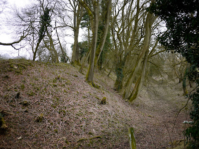
The route back again crosses the Portway and then you turn left and walk along the line of the ridge beneath the Hannington radio beacon. At the end of this stretch there was a fine mossy bank with bare trees.


At the base we saw an early indication that spring might, at last, not be far away with this Cuckoo Pint just beginning to unfurl its new leaves.


The final leg is beside a gallop and back to Kingsclere via the recreation ground.

From: Rambling for Pleasure: Kennet Valley and Watership Down by David Bounds for the East Berkshire Ramblers’ Association Group.

Map: Explorer 144 (Basingstoke).

Conditions: dry, but a cold wind.

Rating: four stars
. So wide open and quiet; wonderful views.


Sightings

Buzzards, kites and a flock (if that's the right word) of finches.

Sunday, 7 March 2010

Paris: St Michel - Luxembourg - Gobelins

Le Palais du Luxembourg

We began this walk at the intersection of two of Paris's great streets: Boulevard St Germain and Boulevard St Michel (Boul Mich to true Parisiens and bluffers alike). The route initially goes past the Hotel de Cluny, now a museum of medieval art, the former Cordeliers convent, and the house where Sarah Bernhardt was born. You return to Boulevard St Germain and pass the fine statue of Danton ...


...to turn into rue de L'Odeon with the Theatre de l'Odeon itself standing proudly at the end, following the precepts of classical street planning.


In fact it is the rear facade - actually more impressive than the main one.

From here it is a few steps to enter the grounds of the Palais du Luxembourg. The building, which now houses the Senate, is mainly 19th century, but the gardens were laid out in 1613 for Marie de Medeci, widow of Henri IV.

There were an extraordinary number of joggers, many of whom seemed to be on a "round the Luxembourg fun run". There was immediately a lovely view towards Les Invalides.


We walked across to the handsome Orangerie.


Just as in the Palais-Royal yesterday - and on a much larger scale - the gardens were busy with people practicing tai chi, sword fighting and all sorts of exotic oriental activities. The reminiscence of what we saw in China was strong.

Returning to the main section of the garden, we walked away from the elegant 19th century facade ....


...and left the Luxembourg to the south to join the long, and rather quieter, Jardins de L'Observatoire.

We were thrilled by the fantastic 1927 Ecole d'Archeologie by the anti-modernist architect Paul Bigot. The walk book describes it as "ugly", but the combination of elements and styles seemed to us to be wonderfully different and striking.


At the end of the jardins is the Observatoire itself, a neo-classical building of 1672. Apparently the Paris meridian splits it exactly in half. Which of course invites the question what is or was the Paris meridian. According to Wikipedia it is now longitude 2°20′14.025″ east, but was a long-standing rival to Greenwich as the prime meridian of the world, as was the Antwerp meridian in Flanders.

In the rue Cassini, just to to the left of the Observatoire, our guidebook drew our attention to three quite lovely houses designed on the cusp of Art Nouveau and Art Deco by the Belgian architect Louis Sue. This is number 7.


At this point we had to abbreviate the rest of the route and head directly for our lunch rendezvous at Place d'Italie. This meant we missed the 17th century abbey church of Notre Dame de Grace and a couple of streets in the Gobelins district. However, we did pass the Manufacture Royal des Gobelins, which made tapestries. The handsome facade dates from 1912.


From: Gilles Desmonds - Walking Paris (New Holland).

Conditions: clear, sunny, bitterly cold wind.

Rating: four stars. Lovely gardens and some wonderful architectural surprises.

Saturday, 6 March 2010

Paris arcades (Les Passages)

Galerie Vivienne

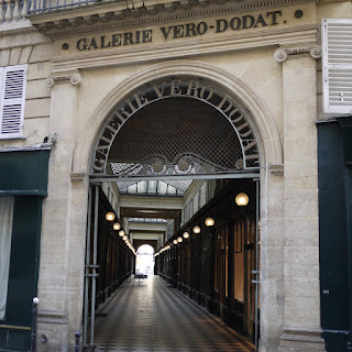
This walk in "Paris inconnu", to quote our walk book, presents a tour of the city's 18th and 19th century arcades. You start at the Louvre and heading north soon reach the Galerie Vero-Dodat, opened in 1822 by two charcutiers called, reasonably enough, Vero and Dodat. The shop fronts have uniform round arches with slim brass columns and are very harmonious in a slightly faded way. Apparently this total concept of design was unusual at the time. The galerie was gas-lit from the 1830s and remained successful the rest of the century.


Emerging from Vero-Dodat you soon pass through an archway into the Palais-Royal, built for Cardinal Richelieu in 1629-35 by Jacques Lemercier. In the main courtyard, the Cour d'Honneur, there are a number of black and white striped columns of varying heights, mostly very low. They were installed by the conceptual artist Daniel Buren in 1986 and were titled by him "Les deux plateaux". They are, perhaps inevitably known, more prosaically as "les colonnes de Buren". The effect is quite interesting, although they do clash with the neo-classical architecture. They are clearly very popular however with small children, who could be seen jumping on and off the low ones.


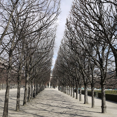
The Palais-Royal is essentially rectangular and behind the Cour d'Honneur is a large court with galeried arcades on all sides and impressively marshaled lines of trees up the centre. We watched some girls practicing kick-boxing. It put us mind of scenes we had observed in the Gate of Heaven park in Beijing.


Leaving the palace, you soon reach the Galerie Vivienne, the most interesting one on this walk. It is 193 yards long and dates from 1826. We especially liked the beautiful mosaic floor.


At the end you are supposed to double back into the Galerie Colbert. This now seems to be offices, rather than the usual shops, and we had to sweet talk the security guard to be allowed access. "C'est juste un couloir" she said, but it was in fact more than a corridor, it was a heavily restored neoclassical gem.

After a stretch of road and a restoring patisserie, next up was the workaday Galerie Choiseul. Some more fairly ordinary streets led to another treasure, the Passage des Panoramas. One of the oldest in Paris, this was opened in 1800 by an American inventor named Robert Fulton. It still retains its vitality, perhaps especially as a result of the profusion of shop signs.


From here you cross the road and go straight into the Passage Jouffroy of 1847 - you can see the date in the handsome clock at the end of the first section - the arcade then makes a dogleg turn to continue.


At the end you cross another road to enter the Passage Verdeau of 1846. This sequence of passages felt like a secret route through the city. The route soon then passed by the wonderful Brasserie Flo, where we temporarily abandoned our study of the arcades to enjoy an excellent lunch in its ornate surroundings.

The next section is frankly a bit boring and the next arcade, the Passage Brady, is terribly rundown. You then come to the imposing Porte St Denis, built in 1672 by Francis Blondel. Its splendour is explained by its role as the king's official entrance to the city. Approached from this side it is wonderfully out of proportion with the narrow street.


The end of the walk was rather anti-climatic. The final passage was to be the oldest and longest in Paris - the Passage du Caire of 1799. However, it was locked and looked very dull, being devoted to wholesale clothes merchants.

From: Gilles Desmonds - Walking Paris (New Holland).

Conditions: cloudy, very cold.

Rating: three and a half stars. A different view of Paris, but quite a lot of tramping along undistinguished streets.