Sunday, 31 January 2010
Chawton
The pretty village of Chawton is known principally for its Jane Austen connections. The walk begins opposite Jane Austen's house, but you immediately head away from it along the road towards St Nicholas church and Chawton House.
The house was owned by Jane's brother, Edward Knight, so there is no immediately escaping the Jane Austen connection. Maybe everybody else knows, but we immediately asked why Jane Austen's brother was not also called Austen? It turns out that he was adopted by Mr. Austen's patron, the rich but childless Thomas and Catherine Knight and took their surname. He later inherited the house from them.
Chawton House is now called Chawton House Library and is home to a charity with a unique collection of books focusing on women's writing in English from 1600 to 1830. Pevsner is fairly scathing about the building: "its details are so much restored that it is no longer a pleasure to look at" and "the best thing is the stables".
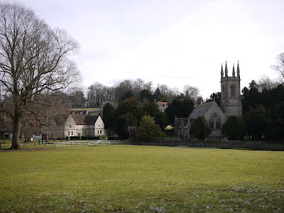
The stables on the left (now seemingly a dwelling), the church (by Sir Arthur Blomfield, 1871) and the house make a very picturesque grouping.
From here the route follows the A32 for a short way then heads across a field to enter a copse and then follows a track across country to Farringdon - one of Jane's favourite walks apparently.
Here you walk in a square around a delightful village, with interesting houses of many different periods. We just loved this late Victorian number, with its characteristic terracotta panels. It is Massey's Folly and was designed and built by the then vicar. It is now the village hall. Pevsner is a bit snooty about the terracotta panels - widely available from catalogues - but still very affecting and decorative. Well, I like them anyway.
Just around the corner, reasonably enough, you come to the church. You can plainly see from the outside the Norman nave and tower on the left and the Victorian chancel on the right. The porch is harder to guess - it dates from 1635.
In the church yard is this magnificent yew, with its vast girth and hollow middle.
You leave Farringdon and head west, crossing the A32 to reach the line of a disused railway, which you follow, crossing under a leafy bridge to the outskirts of Chawton.
Here we saw several members of the (we supposed) Chawton Metal Detection Society hard at work in the fields. Back across the A32, through some houses to return to the start.
From: Pocket Pub Walks: Hampshire by Nigel Vile (Countryside Books).
Map: Explorer 133 (Haslemere and Petersfield).
Conditions: cold, frozen ground, clear and sunny.
Distance: 4 miles.
Rating: Three and a half stars. Interesting and varied.
Thursday, 28 January 2010
South Cerney
En route for Gloucester, I made a slight diversion to explore South Cerney and the Cotswold Water Park. I had been past many times, seen the signposts - now for the walk!
The walk begins on the northern edge of the sprawling village of South Cerney. You quickly join a raised path which skirts the village to the east, leaving it at the former railway bridge shown above. A short way further on you join the banks of the former Thames and Severn Canal. I walked along another section of this recently at Sapperton and described its story in that post.
The canal-side path is unique in having a large number of trees. The effect is quite melancholy.
After following the path for a while you come on a defunct lock and a ruined lock-keeper's cottage.
After crossing a road, you can continue along the canal (now more open) or walk beside one of the many lakes. I chose the latter option, but it was very wet underfoot and only coots were in sight.
Rejoining the canal, you come on a splendid round house, apparently dating from the 18th century, when it was used by lock keepers and maintenance engineers. The gothic doors and windows were delightful.
At this point you enter the much smaller village of Cerney Wick, and cross some fields by another lake to join a path along the line of the former railway. As you get closer to South Cerney you pass between weather-boarded housing developments bordering further lakes. There is a strong New England flavour to the design of the houses: quite attractive, but also rather incongruous.
On reaching South Cerney you briefly walk along the wonderfully named Bow Wow Lane, with a stream on either side to return to Silver Street where the walk began.
I diverted here to see the church with its fine Norman tower and doorway.
From: 50 walks in Gloucestershire (AA).
Map: Explorer 179 (Gloucester, Cheltenham and Stroud).
Conditions: wet underfoot, cloudy, drizzle, quite cold.
Distance: 5 miles.
Rating: three stars. Flat (obviously), wet, an odd combination of abandoned transport systems and modern housing developments.
Sunday, 24 January 2010
Tilehurst and Sulham (Nunhide Lane and Horsemoor Wood)
Back home from St Lucia and back to reality with a walk on Berkshire clay with the M4 ever-present in the background.
This walk starts on the western edge of Tilehurst by the recreation ground in Little Heath Rd. You head west through Harefield Copse and soon emerge into open ground to pass by the red brick tower shown above, which the walk book helpfully identifies as John Wilder's folly. Wilder was apparently vicar of Sulham for 56 years until 1892. Unusually, I could find no further information from either of my most trusty sources: Pevsner and Google.
After passing a farm, the route goes along open fields and it becomes clear that the tower has been placed in a classic folly (foolish?) location on a ridge.
The route is now getting near to the M4 and the traffic noise mounts accordingly. The next stage in fact involves crossing the motorway to do a loop on the other side. Following the more-is-more philosophy applied to walking steps, we followed this route but were eventually beaten back by the second of two extensive areas of flooding. It was no loss.
Further field paths lead to the hamlet of Sulham and St Nicholas's church of 1838.
From here, and the nearby Sulham House, rebuilt by John Wilder, it becomes clear that the tower was carefully placed to provide a focal point at the end of a long vista.
Afterwards, Nunhide Lane leads to a lovely path across open country into woodland and then back to Little Heath Road.
From: Rambling for pleasure around Reading (first series) by David Bounds for the East Berkshire Ramblers.
Map: Explorer 159 (Reading, Wokingham and Pangbourne).
Conditions: cloudy becoming sunny, quite cold, very muddy underfoot.
Distance: 5 miles.
Rating: Two stars. Surprisingly open country so near to Reading, but marred by the constant noise. The extension across the motorway served to increase the step count, but was otherwise pretty pointless.
Sightings
Well we did see a kite, so all is not lost.
We also saw some early snow drops (I must learn how to get my camera to focus on small white subjects!).
And on the last leg of the walk we saw a Great Black-Backed gull standing out among a crowd of other gulls on a flooded field.
Monday, 18 January 2010
Pigeon Island
On holiday in St Lucia. It's very hot and not easy to reach the small number of designated trails, so we haven't done any walking so far. However, Pigeon Island is only a short taxi ride away from where we are staying and there is no excuse for not doing this walk.
Pigeon Island is in fact no longer a real island, having been joined to the mainland by a causeway in 1970. It is now a National Park owned by the St Lucia National Trust and it has an interesting, and violent history. It was a pirate stronghold in the 16th century and was fortified in 1788 by Admiral Rodney (for whom nearby Rodney Bay is named). It was at that point a strategically important location in relation to France's key base at Port Royal in Martinique 25 miles to the north. It was from here that Rodney defeated the French at the battle of the Saintes in 1782, ending French naval power in the Caribbean. It was later used as a whaling station and as a naval wireless base by the Americans during the second world war.
The walk begins with a fine avenue of trees leading away from the main entrance to the park.
A short detour leads down to a pleasant beach with a view of Rodney's Fort ahead.
We resisted the temptations of the beach and continued uphill along a leafy track.
At the end of this, there is a steep climb up to the Fort. There is not much there - just a few old British cannon and the remains of the powder room - but there are fine views to the south. To the north, there is a fantastic view of the ridge which leads up to Signal Peak at 110m.
You walk up the grassy ridge, and then round the right side of the peak and up a steep winding path to reach the summit. There are great views to the north, where on a clear day you can see Martinique. We enjoyed the view back down to the Fort.
There is a sort of flag pole at the top and we climbed its base and had our picture taken. As does everyone who makes it this far. Then we retraced our steps.
Distance: Only about 2 miles, but a good work out.
Conditions: Very hot.
Rating: Four stars.
Sunday, 3 January 2010
Alresford
We decided to go a little further away from home than usual for this walk in the pretty Georgian market town of Alresford (pronounced Allsford). It is sometimes referred to as New Alresford, to distinguish it from the much smaller Old Alresford, a mile or so to the north. The helpful town website reveals that Old Alresford was mentioned in the Domesday Book and that (New) Alresford was founded as a planned new town in the early years of the 13th century.
The walk starts at the car park by the station, which is now one end of a refurbished steam line to Alton, the Watercress Line. The station itself is exactly like the Southern Region station in Claygate where I first caught the train to school in 1961.
You walk down Station Road to join West Street and where it runs into East Street, you quickly turn left into Broad Street. The T shaped arrangement of the main streets goes right back to the town's founding. Today Broad Street has a Georgian character.
At the bottom is the tiny Victorian fire station.
You are soon out of the town and then follow a path down to and then alongside the river Alre, or possibly Arle. It seems clear that Alre is the original name, and it is how the river is shown on the OS map, but some signs and several house names refer to Arle. Perhaps Alre was too hard to pronounce?
We enjoyed the unusual sight of this cottage straddling the river.
A little further on the church of Old Alresford becomes visible across some of the watercress beds which are dotted around the area. From Pevsner I learned that the church (St Mary) dates from 1753 and the handsome brick tower with its impressive finials from 1769.
On the edge of Old Alresford you take the Ox Stone Drove for a mile and a quarter to reach Abbotstone. This is a pretty spot surrounded by hills and is almost too small to be called a hamlet. We ended and started legs of the Three Castles Path here last year.
You walk up the lane to the south, with a nice view back ...
... and turn onto another track, confusing called the Ox Drove, part of the Wayfarers' Walk, and follow this, crossing a road, back to the outskirts of Alresford.
The final section follows the banks of the Alre and passes by this interesting early 19th century building known as the Eel House. The three arched channels now control the water flow, but may once have contained eel traps.
From: Pocket Pub Walks: Hampshire by Nigel Vile (Countryside Books).
Map: Explorer 132 (Winchester, New Alresford and East Meon).
Conditions: blue sky, very cold, ground frozen.
Distance: 5.5 miles.
Rating: Four stars. Varied, some interesting sites, lovely tracks, quiet open country.
Friday, 1 January 2010
Compton
What could be better than the Berkshire Downs for a new year's day walk to clear the head after the previous night's celebrations?
This walk starts at the Compton Swan pub in the centre of Compton. The church with its fine 13th century tower is actually outside the village, but it makes a nice heading for this post. You walk along two village streets, cross under the former railway bridge and you are immediately on a track, sometimes open, sometime hedged, which leads up to the Ridgeway.
In the open bits, you can see the Downs stretching away to the west.
Once at the Ridgeway there is a choice between walking along it (which is what we did) and crossing over to make a circuit around Lowbury Hill and rejoining it later.
The route then follows the Ridgeway for a couple of miles with the Downs stretching out ahead.
After crossing another disused railway bridge, due north of Compton on the same line as the earlier one, you head south along gallops, with nice views to the west, to return to the village.
From: West Berkshire Council leaflet: Walking in West Berkshire 1.
Map: Explorer 170 (Abingdon, Wantage and Vale of White Horse).
Conditions: blue sky, very cold, ground frozen.
Distance: 5 miles.
Rating: Three stars. Quiet open country, but little of interest to see.
Subscribe to:
Posts (Atom)