Friday, 27 November 2009

Withington

Withington

En route for Gloucester, I followed my normal practice of diverting to find a walk. However, because I had to be there for 11.30, I had to start this one in Withington before 0900, a new experience.

Although this is officially a pub walk, I started from the church, walked up the road past typical Cotswold cottages ....


... and soon turned off on a climbing path across fields to reach a ridge crossed by power pylons at 220m. This was a climb of about 60m, and the reward was a fine view back to Withington, nestling in the Coln Valley. I walked along part of the Coln in August at Fairford, on another trip to Gloucester.


From here, the route led across a large field with Withington Woods on the left to intersect a track which leads into and then round the back of the woods. In a hollow, you turn left into the woods and follow a pleasant woodland path through a great variety of trees.


Eventually, you emerge to again see the Coln Valley.


Here the path traverses the upper slopes just below the tree line, offering delightful views towards Withington and back along the valley - just a shame about the pylons.


Eventually, you rejoin the path you climbed by and use it to return to the village. The church of St Michael and All Angels is of Norman origin, but took its present form in the 13th, 14th and 15th centuries.


From: Pub walks in Gloucestershire by Nigel Hammond (Countryside Books). I must say that the sketch map - a weakness of this series - was woefully inadequate to provide any guidance for this walk. And the directions on first reaching the ridge were pretty vague too. However, my OS map saved the day.

Distance: 4 miles.

Map: OL45 (The Cotswolds).

Rating: three and half stars. A good workout, nice views, very muddy in the woods.

Wednesday, 25 November 2009

Wherwell

One of the many thatched houses

We decided to fit in a mid-week walk plus pub lunch and go further afield than usual for it, as it was such a nice start to the day. Wherwell is a very pretty village just south of Andover, and the walk starts at the White Lion Inn.

You walk down the round away from the village and turn onto the Test Way. You cross the river and emerge on to the splendidly named Chilbolton Cow Common. You cross a tributary of the Test and, looking back, enjoy the view of the common, with the other side of the Test Valley in the distance.


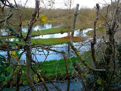
You then follow a path parallel to the river and soon have this striking view of a series of water courses, with the Test now in the background.


Next you cross the road and climb up and over West Down Countryside Park, with great views on the way back down to the river valley.


After following the line of the Test again for a while, you cross it ...


... and then you enter the valley of the River Anton. You climb up a lane to then walk along fields on the side of the valley and enjoy lovely views. Descending again, you cross the river. Here we finally got a close up view of the striking, bright orange trees which we had seen at various points in the valley.


I am pretty sure these are purple willow - which grow by river banks and are used for withies. The name comes from the colour of the young shoots.

The final stretch took us past a section of the long-closed Andover to Southampton railway, the Sprat and Winkle line.


We returned to the pub for a good lunch, chosen from its surprisingly extensive menu.

From: Pocket pub walks: Hampshire by Nigel Vile (Countryside Books).

Map: Explorer 131 (Romsey, Andover and Test Valley).

Distance: 5.5 miles.

Rating: three and half stars. Very varied, and some great views, but we felt that the various elements had been joined together a bit arbitrarily.


Sightings

We saw a Little Egret on the river at the far side of Chilbolton Cow Common. I tried to take its photo but every time I advanced close enough to be in range of my zoom lens it flew off. It seemed to have an exactly calibrated safety zone.

Amazingly, we also saw a lone butterfly flying vigorously. I am virtually certain it was a Peacock, but I suppose it might have been a Red Admiral.

Friday, 20 November 2009

Pyrford

The River Wey

Continuing to follow my 2009 resolution, I fitted this walk in on my way to have lunch with a friend in Cobham. The walk begins at the bridge over the River Wey on the road between Ripley and Pyrford. You cross the river and commence the walk by continuing along the road to Pyrford, with water meadows on both sides. Almost immediately you see on the right the ruins of Newark Priory- my second set of abbey ruins in a few days (we saw those of Waverley Abbey on Tuesday). Pevsner explains that it was a house of Austin Canons founded in the 12th century and laments that today "its satisfactions are purely picturesque". The Austin Canons were also known apparently as the Augustinian or Black Canons, a monastic order.


Further on up the road, a steep path leads up to the pretty Norman church of St Nicholas.


The next section of the walk is less inspiring: across fields under electricity pylons and then a dog-leg route through a golf course. However, at the end you reach the Wey again at Pyford Lock. This was quite nostalgic for me as I realise that I went fishing here with my father forty-odd years ago. I vividly remember fishing into the dusk once the fish started biting.

This section of the river is known as the Wey Navigation, a canalisation of the river to take barge traffic dating from 1653.


Further along the river bank you come to Pyrford Place. It is mostly invisible, which is apparently no loss as Pevsner describes it as "a nondescript house". What you can see however is the 17th century summer house in which John Donne lived for two years with his young wife.


Next you come to Walsham Lock, which has the distinction of being the only turf-sided lock on the Wey. The change of levels is minute and perhaps this allowed a more minimal approach to lock construction.


Soon you cross to the right bank and you can now see Newark Priory more closely.


From here it is a short distance back to the start.

From: 50 walks in Surrey (AA).

Map: Explorer 145 (Guildford and Farnham).

Distance: 3.5 miles.

Rating: three and a half stars. Lots of interesting things to see, but let down by the boring middle section.


Sightings

I saw this heron in a field by the river edging its way across, leading with its head. I am not sure what it was really up to, but for a moment it looked as though it was going to make an assault on the flank of this old horse.

Tuesday, 17 November 2009

Tilford (Waverley Abbey to Frensham Little Pond)

Waverley Abbey

We met up with friends to continue a series of very good walks in Surrey - previously we had done Box Hill and Leith Hill. The walk starts a couple of miles south east of Farnham at the car park near the ruins of Waverley Abbey. The first sight you see however is one of several war time pillboxes which are a feature of the area. I made some notes about them on an earlier walk along the Kennet and Avon canal.

We began with a detour to see the abbey ruins, first walking along the banks of the Wey with the handsome Georgian Waverley Abbey House on the opposite bank. It is now a training and conference centre, owned by CWR, a "christian charitable organisation" according to the house's website.


Pevsner describes Waverley House, as it was when he wrote about it in 1966, as "a puzzling house". The central porticoed part seems to have been built in 1723 by Colen Campbell for Aislabie, the Chancellor of The Exchecquer. The wings were added about 30 years later, but teh whole house is said to have been rebuilt - presumably exactly in 1833.

You reach a lovely bridge over the Wey and turn left to reach the abbey ruins (see above).


The abbey was founded in 1128 by the bishop of Winchester and was the first Cistercian abbey in England. the abbey church had a long nave with no aisles and squat square transepts. All that remains is one transept and parts of a couple of domestic buildings. This was part of the lay brothers' range.


The site is lovely, surrounded by woodland and fields, and included this splendid yew tree.


Returning to the car park to (finally) begin the walk proper, you cross the river Wey and walk along the road, eventually turning right into a byway through very pleasant woodland. This emerges onto a road which leads into Tilford. You cross the medieval bridge ...


... and walk alongside the large village green and up the hill, turning right into a track which takes you through woodland to reach Little Frensham Pond, originally a medieval fish pond.


The pond has the classic surroundings of sandy soil and pine trees. It looked positively Mediterranean in the unseasonal (and unexpected) sunshine.


From here another woodland trail and a bit more road led back to Tilford, where we had a light but restorative lunch in the delightful Barley Mow pub. "England as you expect it to be" justifiably proclaims its website. In the pub, we realised we had passed by the 800 year old Tilford Oak in our rush to reach the pub before it stopped serving food. It has been severely lopped and its trunk has been patched with iron sheets.

We returned along the side of the Wey valley and later along a delightful sunken lane through Sheephatch Copse.


From: 50 walks in Surrey (AA).

Map: Explorer 145 (Guildford and Farnham)

Distance: officially 6 miles, but seemed to be nearer 7 with our diversion.

Rating: four stars. Lots of interest and variety. An oasis of peace, although not that deeply in the country.


Reflections

This is probably the first time that a detour at the start of a walk has been given more attention than the walk itself. But there is a lot to be said for starting walks in places which are inherently interesting and attractive. Our recent walk from Dorchester and one I did in August from Fairford would be good examples.

Sunday, 15 November 2009

Cuckhamsley Hill

The Ridgeway

We wanted a nice Sunday morning walk which would not be too muddy after the recent heavy rain - and this clearly pointed to higher ground. This walk, partly along the Ridgeway, had its official start point at Cuckhamsley Hill. But as this is only accessible from East Hendred to the north, and this would have added a lot to our journey there, we started part way round at the wonderfully (and mysteriously) named Lands End, near West Ilsley. There is a copse and an isolated cottage in a pleasant valley.

From here the route leads up a wide shallow valley towards a gap in the trees, just beyond which is the Ridgeway. The track goes by the well-chosen name of Old Street.


At the top you turn east onto the Ridgeway and follow it along an open ridge with fine views north into Oxfordshire. After a while there is light woodland on either side.


And at the end of it, on the right, is a Saxon burial mound - Scutchamer Knob. As you approach you see a mound shaped like an open horseshoe, with a few trees silhouetted on the top. Unfortunately, the sun was directly behind the trees, so I had take my photograph from the other, less interesting, side.


The Cuckhamsley Hill (203m) car park is immediately after the burial mound and the Ridgeway stretches away towards Bury Down, part of our Berkshire Way walk - see photo at the top of this post. Our route however turned right here and followed a delightful descending track back down to Lands End. There were lovely views over the undulating downland to the east.


From: Chilterns and Thames Valley (Pathfinder Guides).

Map: Explorer 170 (Abingdon, Wantage and Vale of White Horse).

Distance: 4 miles.

Rating: four stars. Exhilarating, quiet, that away-from-it-all feeling. Short, but perfectly formed.


Reflections

As I was descending the final section of the route I saw the clump of trees in the last photo and I was watching for the right moment to take a photo which would capture them and the subtle curves of the landscape. It was very striking how quickly the image changed. Obviously it was the combined effect of descending through countryside which was itself constantly changing. But it gave the landscape a sense of real dynamism.

Saturday, 14 November 2009

Burford

The High Street

We were visiting friends in the Cotswolds and the plan for this morning was a walk starting from Burford. However, the weather was very uncertain and as it started raining heavily when we arrived at Burford we decided to limit ourselves to a stroll around the town. Pevsner describes Burford as "a remarkable small medieval town". The town's prosperity was based on wool and coaching inns and unusually it had no lord of the manor before the 17th century, being governed by an alderman and burgesses. On a drier day, armed with the Oxfordshire edition of the Buildings of England, we would have got even more out of it.

We approached from the west, parked at the end of Sheep Street (pretty appropriate) and walked along it to join the High Street at about its midpoint - shops to the left going down to the river, but gradually becoming residential uphill to the right.

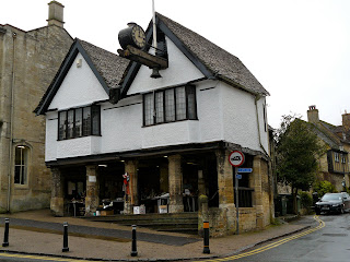
Immediately opposite we saw the first of many fine old houses. Pevsner dates WJ Castle to the late 15th century and comments as we did on the carved barge boards.


We walked down the high high street, dodged a shower in a delightful art gallery, and reached the medieval bridge over the swollen brown Windrush. We then turned round and went to the left to reach the church of St John Baptist.

The church is Norman in origin - we noted a typical doorway on our approach and the central tower has the typical round arches and thick stonework. The building was extended and remodeled in the 13th and 15th centuries to create the impressive but rather incoherent structure you see today.

One of the most extraordinary features of the interior is the elaborate 17th century tomb of the Tanfield family. Sir Lawrence Tanfield purchased the lordship of the manor in 1617 and this rather reduced the power of the burgesses who had previously run the town. The tomb was apparently just installed in this chapel by his grandson without permission, occasioning much grumbling. It is tempting to see it as a reaffirmation of who was now the boss.


Outside in the churchyard there is a group of bale tombs of the late 16th and early 17th centuries.


Only now could the facade of the church be clearly seen - and it was too wide to be squeezed into the frame of my camera. The porch is particularly impressive.


We returned to the High Street via Guildenford and Witney Street and were now facing the 16th century Tolsey or Court House. The tolls which were collected here were from people who wished to trade in the town's market.


Another shower drove us, without much resistance, into the Highway Inn of about 1500 where we had a nice lunch before returning home to watch England's dismal performance against Argentina.

Conditions: wet obviously.

Distance: probably no more than a mile.

Rating: four stars.

Friday, 6 November 2009

Crazies Hill

The Horns, Crazies Hill

Another impromptu walk. We decided quite late in the morning, so we looked for a walk starting at a pub where we could have a bit of lunch first. Lunch at the 16th century The Horns was excellent. The hamlet of Crazies Hill is north of Wargrave, where we had a pleasant walk earlier in the year. It turns out that it is not a mad-house - crazies was a local name for the buttercups which used to abound here.

You turn right out of The Horns and shortly turn right past the impressive white porticoed front of Crazies Hall, hiding behind high walls. Amazingly, this was once Henley Town Hall and was dismantled and moved here in the late 19th century. (The current Queen Anne style town hall in Henley dates from 1900, which is consistent.)


From here, you cross fields and follow a road a short way before turning onto a fenced path with lovely views towards what seems to be the park of Hennerton House, a mansion dating from 1817.


You climb past the golf course and cross fields before entering the splendidly-named Bottom Boles Wood. This turned out to be the nicest part of the walk, with some very pretty beech copses within it.


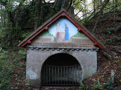
After a left hand turn the route continues through further woodland to pass Rebecca's Well, which is said to have once been the main water supply for Crazies Hill. The existing structure was built by new curate in 1870. The fresco depicts the biblical story of Rebecca, chosen to be Isiah's wife when she went to the well. However, the local name for the well was previously Rebra's well and it seems the Rebecca connection is a fanciful interpretation by the curate. Still, it was a wonderful wayside discovery.


Weather: dull at first, then rain.

From: Pub walks for motorists: Berkshire and Oxfordshire by Les Maple (Countryside Books).

Map: Explorer 171 (Chiltern Hills West).

Distance: 4.5 miles.

Rating: three and half stars.


Sightings

We were, in a loose sense, followed for much of the way by a cruising kite. We wondered if the kite should be the new emblem of Berkshire.

We just loved these impressively straight-backed cattle in a field on the edge of Crazies Hill.


And although Fly Agaric is far from unusual, we enjoyed the orange (rather than the normal red) shade of this pair, spotted in the wood.

Wednesday, 4 November 2009

Burnham Beeches

Burnham Beeches

A lovely sunny autumn morning and I made an impromptu decision to go immediately out for a walk. And where better on such a day than Burnham Beeches? Not everybody knows that it is owned by the City of London, who bought the site in 1879 when it was on sale as land for housing. It is now maintained as a nature reserve. One manifestation of this is that fallen branches are left in place, unlike at Westonbirt Arboretum, where we walked a few days ago, which is remarkable clean and tidy beneath the trees.

Equipped with an excellent leaflet, available from the information centre, I set off along Halse Drive, one of the main routes into the wood. I had roughed out a clockwise circular walk to get a good sense of the Beeches.


After a short distance, in a dip, I turned left onto a footpath named Victoria Drive. Already I appreciated the discrete names for all the pathways which are displayed at major junctions. Burnham Beeches is not as dense as many woodlands, but these signs certainly deal with the greater risk of getting lost when on a walk through woods. We saw the same sort of thing on a much larger scale in the forest of Fontainebleau recently.


After a while, approaching the road which bounds this side of the woods, I turned off onto a smaller path to the right to walk parallel with it. I emerged at the junction of Green Lane, Pumpkin Hill and Park Lane and walked up the quiet Park Lane with woodland on both sides. I soon re-entered the wood and headed along McAuliffe Drive.


The wood was more open here and soon looked even more different as the beeches gave way to Silver Birch and Oak. Crossing Halse Drive again, I continued on the delightful Burnham Walk - possibly the prettiest of the paths so far.


This curved round to again reach Halse Drive where I planned to retrace my original path back to the start. However, I was enjoying it too much to stop, and I spotted an opportunity to turn the route into a figure of eight and see some more corners of the wood. I headed across and quickly turned left up Mendelssohn's Slope ...


... to eventually reach another of the main thoroughfares, Lord Mayor's Drive, where I had noticed the Druid's Oak marked on the map. This turned out to be a battered, pollarded oak, 800 years old - the oldest tree in Burnham Beeches.


I followed Lord Mayor's Drive back to the car park, just taking a short diversion to the right to see the Upper Pond.


Distance: about 4 miles.

Map: Explorer 172 (Chiltern Hills East).

Rating: four stars. Lovely colours, including a surprising amount of green from young beech leaves, and more variety than I had anticipated.


Sightings

Passing through a clearing on the edge of the wood I was pleased and surprised to see a very late-flying Red Admiral. The excellent Learn about butterflies site also reports sitings of red admirals this week - and 10 other species.

I could not resist photographing this sign. The "Please don't pick the mushrooms" message is unremarkable, but the translation into (only) Polish was unexpected. I had noticed some Polish shops as I drove north out of Slough, so that is part of the explanation. Does Polish cooking depend heavily on wild mushrooms?


Postscript

It was clouding over as I finished my walk, and pouring with rain by the time I reached home 35 minutes later. Strong reinforcement for applying the principle of carpe diem.