Tuesday, 29 September 2009
Bibury
In Gloucestershire on family business, we decided to fit in a walk. This one starts from Bibury, famously described by William Morris as the most beautiful village in England.
You cross the clapper bridge over the River Coln and immediately walk past Arlington Row, a group of seventeenth century weavers' cottages now owned by the National Trust. It is the epitome of the picturesque.
From here, you head uphill and quickly leave the village for a path along a field edge. At a crossing path you turn left and head south east towards Coln St Aldwyns. This lovely path follows a ridge with views to the south and then skirts round a hill. This is the view looking back.
After a few yards along a road, the route goes across some flat and uninteresting fields before entering parkland and descending down to the banks of the Coln again on the outskirts of Coln St Aldwyns.
You turn sharply left here for the return leg paralleling the Coln. Gradually you approach the river bank and gain a clearer sense of what the river looks like here.
A climb through woodland and then a gradual descent bring you back to the outskirts of Bibury, where a short detour reveals the delightful church of the Virgin Mary in a quiet close with the primary school opposite and the former manor house (now a hotel) nearby.
The church is Saxon in origin and there are a few identifiable remains of this period as well as Norman doorways, 14th century windows with Decorated tracery and the impressive 15th century tower, unusually placed at the end of the north aisle.
From: Cotswold Walks (Jarrold).
Distance: 6 miles.
Map: Explorer OL 45 (The Cotswolds).
Rating: Four stars.
Sightings
Here is the first fish to feature on this blog: a trout in the clear water at Bibury.
A few butterflies as well: Painted Lady, Small Tortoiseshell, Brimstone, Whites, Speckled Wood and a glimpse of what might have been a Small Copper.
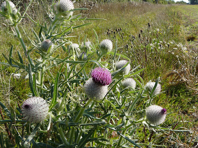
Flower of the day
This Spear Thistle was impressive, although it is of course an Injurious Weed as defined in the Weeds Act of 1959.
Tree of the day
This splendid Ash was standing in the parkland at the edge of Coln St Aldwyns.
Saturday, 26 September 2009
Lambourn
View towards Lambourn
This walk begins in the centre of Lambourn and involves an oval route to the south east. The first part of the walk is the same as the route we followed in June 2008 on the Lambourn to Hungerford leg of the Berkshire Way. You quickly leave Lambourn and follow a mainly rising track between field hedges.
What was new this time was that the walk book helpfully pointed out the Watts Reserve, a grassy slope off to the left belonging to the Berks, Bucks and Oxfordshire Naturalists Trust. We paused to explore. There were lots of wild flowers still and the information board promised a rich selection of butterflies earlier in the season. One to return to next year. The view from the top of the slope was very attractive.
A bit further on we had an unusual experience - being made to slow our pace by a horse in front. The horse and its rider overtook us comfortably enough, but then it seemed to find the combination of the stony rutted track and a descent quite tricky and slowed down markedly.
Reaching a cross roads by the 15th century thatched Cleeve Cottage, we left last year's route and headed along another, more open, but equally stony track. At the end of a slight rise there were excellent views over the Lambourn valley to the right.
And emerging between two hedgerows, Lambourn could be seen again in the middle distance (photo at the top of this post).
We descended between open fields to reach and then turn to walk alongside, the River Lambourn. Sadly, it is currently dry. (Very different from how it was on my Eastbury to Lambourn walk, also last year.)
Gradually the fields give way to the outskirts of Lambourn and then the town itself and you return to the car park off the High St.
From: Village walks in Berkshire by the Berkshire Federation of Women's Institutes (Countryside Books). Probably the best walk in the book.
Distance: Allegedly 5 miles, but seemed much closer to 4.
Map: Explorer 158 (Newbury and Hungerford)..
Rating: four stars. Lovely views and full of interest.
Flower of the day
I spotted this beautiful Clustered Bellflower on the Watts Reserve.
Berries of the day
Less obscure than yesterday's, this Blackthorn was also on the Watts Reserve.
Tree of the day
I am not sure if this will be a regular feature, but the excellent walk description alerted us to this handsome specimen at the Cleeve Cottage cross roads. It is a field maple, our only native acer.
Friday, 25 September 2009
Shinfield Grange and Hall Farm
A new local walk. Probably I have been put off because Shinfield has become the site of significant housing development. This one completely avoids the housing estates however.
You start quite close to the M4 motorway by Shinfield Grange, now Reading University's College of Estate Management and head away from both. Within moments you are walking along a pleasant green lane and at the arrive at a tree lined field (above) - apart from the seemingly-distant hum of traffic, you feel that you are instantly in the countryside.
You soon reach the busy A327, walk along it for a short way, cross the river Loddon at one of its least attractive points, and leave the road to follow fields towards Arborfield. You then loop back across the road again into the CEDAR estate (the Centre for Dairy Research. St Bartholomew's church spire can be seen across the fields.
Soon you come to the ruins of the old church, abandoned as being too run down in 1862. Some stonework can just be made out, as well as some brickwork from a later addition.
The handsome Lebanon cedar standing beside the ruins had a fine crop of cones.
After re-crossing the Loddon, a farm track leads back to the start.
From: Rambling for pleasure around Reading (first series) by David Bounds for the East Berkshire Ramblers.
Distance: 4 miles.
Map: Explorer 159 (Reading, Wokingham and Pangbourne).
Rating: three stars. A very pleasant surprise.
Sightings
Nothing particularly unusual, but a nice mix: a deer, rabbits, a group of gray partridges, a few butterflies (Red Admiral, Comma, Whites, Speckled Wood) and a kite (joy!).
Berries of the day
This fine orange specimen seems to be Sea Buckthorn, a plant famed for its medicinal properties and now apparently being used in skin care products.
Sunday, 20 September 2009
Reading (Soutcote and Calcot)
Been feeling a bit below par this week, so our normal Sunday walk was chosen to be both undemanding and local. The walk begins on the edge of the residential suburb of Southcote at the car park for Southcote Linear Park, near to a set of allotments.
Although this is slightly unprepossessing start, you are soon walking along the side of the Holy Brook, which is narrow and a bit cluttered, but still quite attractive. We saw a large family of swans, with no less than seven nearly fully-grown cygnets (not all in shot).
You walk along the river bank for a while and then turn south under the railway and across some waste ground to join the river Kennet at the pretty Milkmaid's bridge - on the route of another Reading walk we did last year.
From here, you walk west along the river bank and eventually reach a weir where the river joins the Kennet and Avon canal. A short way along the tow path you come to Burghfield Bridge, with canal boats moored along the far bank.
... and then cross to the other bank. Further on you pass Burghfield Lock.
Soon there are delightful meadows to the side and a real sense of being in the country. At Hissey's bridge you turn right and very quickly walk through further meadows to reach the banks of the Holy Brook for the return leg.
Sadly, the route soon diverges from the river bank and goes via the former Calcot Mill into the Calcot housing development, latterly along a series of green spaces between the houses and the railway line. You meet the Holy Brook again just before the end.
From: Rambling for Pleasure: Around Reading first series by David Bounds for the
Distance: 4.5 miles.
Rating: three stars. Surprisingly good urban walk. Spoilt only by the final stretch.
Map: Explorer 159 (Reading , Wokingham & Pangbourne)
Flower of the day
Not many flowers about, but this White Mustard grew in profusion in the wasteland between stream and river.
Berries of the day
Some of the berries of autumn need no introduction: wild rose hips, holly, hawthorn, elder, rowan. However, recent walk in Priddy in Somerset resulted in us noticing the Wayfaring Tree, whose berries were at that stage red and would later ripen to black.
Today we saw these two.
The first turns out to be Spindle-tree (Euonymus europaeus). The pink fruits will later split to reveal orange seeds inside.
The second is a Guelder-rose (Viburnam opulus). The name comes from the Dutch province of Guelderland.
Saturday, 12 September 2009
Banyoles
Fresh from looking round the delightful town of Besalu, with its wonderful fortified bridge, we decided to walk around the lake just near Banyoles, the Estany de Banyoles. The lake, loosely described as being in a figure-of-eight shape, is fed by underground streams and is 62m deep in places.
There is a continuous footpath all round the lake, so we decided to begin on the side furthest away from the town. The ideal start point was the little romanesque Iglesia Santa Maria at Porqueres.
We headed anti-clockwise from here, initially at some distance from the edge of the lake, although there were spurs from the path towards "miradors" - viewing platforms, more often to be found on high ground (for example on our walk near Begur).
As we approached the town side of the lake, the path continued along the lake side and the first of a number of private bathing or boating huts came into view. These were in a range sizes, colours and styles. This was our favourite.
The path then continued along a stately avenue of trees ...
... past further, grander bathing facilities and other signs of urbanisation and then became quieter .
The views of the lake from this end were easily the most attractive, with variations in the depth of the water readily apparent from the differences in its colour.
On the final leg back to the church the thunderstorm which had been threatening all afternoon finally began, but happily we were right on the edge and did not get too wet.
Rating: three stars. A nice stroll, with some lovely views and the amusing oddity of the bathing huts, but mostly it felt like walking in the park.
Friday, 11 September 2009
Romanya de la Selva
Into the hills for today's walk, which starts at the tiny village of Romanya de la Selva, inland from Platja D'Aro and on the edge of the Gavarres Mountains at 320m above sea level.
We parked near the pretty romanesque church of San Marti, which dates from the 10th century.
After a short detour to see the Font (fountain) de Prat, the route follows a well marked path (the GR 92.1 long distance path) which ascends gradually towards the Font Josepa, the focal point of this walk - and then continues on through the Gavarres. The springs are a feature of the area and are the result of a geological fault in the mountains.
At first the path is quite enclosed, but excellent views over the Gavarres are revealed as you go further up.
Eventually a short detour leads to Font Josepa, where there are a couple of benches under the shade of a tree to recover and enjoy the view. The white sign in the photo above certifies that the water is safe to drink.
We went a bit further on up the main track in search of another fountain, but decided it was getting too hot so we began the return leg. Rather than simply retrace our steps, we took the alternative route back to Romanya along a forestry "road" - i.e. a wide but rough track. This was easier walking in the end, but the initial price was a sharp ascent up to about 430m to negotiate a route round a large hill. Our reward though was some fine views south towards the coast.
From: Rother Walking Guide to the Costa Brava by Roger Budeler.
Map: Mapes Topografics (Piolet) Baix Emporda Sud.
Rating: Four stars. Great views. Wonderful butterflies ...
Sightings
Right from the start, we saw a series of large brownish butterflies with a flash of orange at the base of the hind wings. They had something of the gliding flight of the swallowtail about them. After a while I realised that we were seeing a species I had read about, but never previously seen: the Two-tailed Pasha. The two tails - which are reminiscent of the swallowtail - are clearly visible in the photo.
Almost as thrilling, was another large brown butterfly, this time with pronounced white bars across the upper side of both wings, but a drab camouflaged brown and white underneath. It was too big for a White Admiral, and the underwings were wrong. Later my butterfly book revealed the answer: the Great Banded Grayling.
Monday, 7 September 2009
Llafranc to Cap Roig Botanic Gardens
The last time we stayed in Llafranc we walked along the Cami de Ronda, or coastal path, from Llafranc to the small beach at Golfet, in sight of Cap Roig. This time, we decided to go on to see the celebrated Cap Roig botanic garden.
We again climbed up the steps from Llafranc, walked along the path and round the headland bringing into sight the bay that houses Callella. This is the view just as you are about to turn the corner into the bay.
We walked through the village and up the long slope on the other side to regain the coastal path, with wonderful views now looking back to Callella, with Llafranc behind.
Here is a typical section of path.
Just before Golfet beach, the path turns inland, up steps and through a housing development to suddenly emerge in open country. The Cami de Ronda continues across country to return to the coast further along at Platja de Castell, while the road leads left to the Cap Roig gardens.
After a further climb we entered the gardens. They are now owned by the Girona regional government, but were created over a forty year period from 1927 by a Russian colonel, Nicolai Woevodosky and his English wife, Dorothy Webster.
The architectural centrepiece is the castle, built in a moorish-influenced gothic style.
In the interior there is a beautiful cloister, with a wonderful holly oak tree at its heart.
There are a series of terraced paths and gardens on the steeply sloping site.
And as you approach the sea, there are vertiginous views down to it.
Rating: Four stars
Sightings
I had imagined that a garden might be just the place to see some butterflies, but the only ones we saw in any quantity were Painted Ladies, which have been plentiful at home this year.
Saturday, 5 September 2009
Begur
This walk begins on the outskirts of the hilltop town of Begur. The nearby Cap de Begur is the easternmost point of this part of the Costa Brava (the Baix Emporda). Following the instructions in our walk book, we turned left looking for the trail signs which marked the start of the walk and were greatly amused to find three cars discharging a party of other walkers at the same point. We were less amused when they proved to be going the same way and making an incredible amount of noise as they did so. We eventually saw them off however.
The start point is at 200m and initially you walk north, down the road towards the sea, immediately enjoying fine views.
The road soon ends and you then follow a track into the scented woods.
You emerge onto a road, having made a short but very steep climb up a bank. As we climbed, we noticed a long thick rope on the ground, attached to a stout post at the top. What a good idea in wet weather when the slope would presumably be impossibly slippery. The walk we recently did around Cheddar Gorge would benefit from something similar.
The road leads to the Mirador de la Creu, a viewing point at 182m. The coast stretches away towards L'Estartit and the Illes Medes in the foreground with the Golf de Roses beyond.
You return to the road and now begin a long descent, after a while through a housing development to reach sea level at the Cala de Aiguafreda. This is a pretty cove, but lacks any beach. We saw a family despairingly searching for somewhere to set up their windbreaker.
Now of course, you have to make the 200m climb back. A stretch of road soon gives way to a delightful path through light, then deeper, woodland.
And eventually you emerge into a nature reserve near to an old watch tower known as the Mas d'en Pinc.
A few more steps bring you back to the trail signs and the car.
From: Rother Walking Guide to the Costa Brava by Roger Budeler.
Map: Mapes Topografics (Piolet) Baix Emporda Nord.
Distance: about 5 miles.
Rating: Three and a half stars. Great views initially, but quite suburban in the middle.
Subscribe to:
Posts (Atom)