Sunday, 31 August 2008

Lardon Chase to Pangbourne (Berkshire Way 8)

Looking south

Today - a damp, misty day - we tackled stage 8 of the BBC's Berkshire Way, from Lardon Chase near Streatley to Pangbourne. Seven and a half miles.

The route heads initially south, out of a wood and into fields with lovely views to the south, albeit restricted by the weather. A series of tracks and sections of road bring you to the rear entrance to Basildon Park (on which more below).

We rather liked this barn conversion - a change from the timber ones which abound in Berkshire.


And we loved this Victorian gatehouse with its Dutch gables.


Then a quite long trudge following the wall of the Park down towards the river (Thames) at Lower Basildon. The walk along the Thames Path which formed the final section of the walk was more enjoyable, with glimpses of Basildon Park on the ridge to the right.

We passed to the rear of the Beale Wildlife park, but sadly could not see so much as a llama, although we did hear a peacock.

The final stretch was almost a mile along the main road down into Pangbourne. Still by the river of course, but it felt like a surfeit of pavement/tarmac. There are some wonderfully extravagant Edwardian houses along here with elaborate turrets and gables and big windows.

Rating: three stars (just). Lovely country initially, but too much road overall. The weather didn't help.

Map:
-->Explorer 159 (Reading, Wokingham & Pangbourne).


Sightings

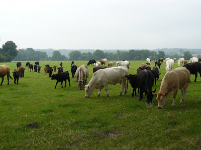
Not much to report really, but this multi-coloured herd of cows caught the eye.


Basildon Park

A slightly shadowy presence on this walk, rather than a real feature. It was built in the Palladian style between 1776 and 1783 by John Carr of York for Francis Sykes, who had made his fortune in India. The most famous feature is the beautiful Octagon Room. It is now owned by the National Trust.

Sunday, 24 August 2008

Bury Down to Lardon Chase (Berkshire Way 7)

Oxfordshire from the Ridgeway

Stage 7 of the BBC's Berkshire Way runs long the Ridgeway from Bury Down, north of West Ilsley to Lardon Chase, on the edge of Streatley. This represents seven and half miles along a single signposted path. You can't go wrong - there is just one place where the Ridgeway is the left turning at a junction, rather than straight ahead as you expect, and one final right hand turn off it across a golf course to the car park at Lardon Chase.

You set off on a broad ride with wide views over the flat Oxforshire countryside, cross the A34 and walk through farmland with horse gallops. You cross a bridge which is one of the last remains of a dismantled railway - presumably but for the Ridgeway it would have been converted into a path or cycle track.

The next section is a bit more enclosed, but creates pleasing views looking back towards open country ...


... and forward as the path wends downwards towards Streatley and the Goring Gap.


You pass the impressive gate posts of Thurle Grange.

Thurle Grange

Soon after this you turn right to cross the golf course, ringing various warning bells as you pass by. The views back towards Thurle Down, which runs parallel to the Ridgeway, are delightful.

Thurle Down

So we are now half way - in stages at least - and we have walked 44 miles in total.

Rating: Four stars - but see below.

Map:
-->Explorer 158 (Newbury and Hungerford).


Reflections

This was a really excellent walk, but for part of the way we felt a sense of slight - what?, frustration? disappointment? On reflection we realised that the problem was a lack of reference points. Walking along looking out over a vista of open country, with neither natural nor man-made landmarks, we felt we were missing something. We felt we wanted some reference points by which we could orientate ourselves and measure our progress. When we came on the section of the Ridgeway we have previously walked we felt better - here was the track that led to Starvall Farm, there was the track towards Aldworth where I took some pictures of the Goring Gap.

I have an evolving list of the things that make for a good walk and now I see that this is one of them - a sense of where you are, relative to the major landmarks. I think that's why I don't really enjoy walks which are wholly within a wood.

Sunday, 17 August 2008

Chieveley to Bury Down (Berkshire Way 6)

Looking back towards Chieveley

This is stage 6 of the BBC's Berkshire Way. The route goes more or less due north from Chieveley, parallel to the A34, through the village of West Ilsley to intersect the Ridgeway at Bury Down. Six miles and three quarters in all.

You head off beside and across fields and then pick up a series of tracks. The first of these, Old Street Lane, offered ideal conditions for butterflies and we saw a number of green veined whites - readily distinguishable from the more usual small whites by their clearly marked veins. I know this sounds rather obvious, but it reinforces the importance of really looking.

This track leads onto a further, more enclosed one, Green Lane. This was slightly sunken and had quite dense trees and bushes on both sides, and it was with some relief that we quite literally emerged into daylight on the downs.

The final section was much more open leading up to and across the pretty village of West Ilsley and then the final climb through fields up to the Ridgeway.

You look back over Folly Down, which is just lovely ....


... and you know you have just about reached the Ridgeway when the delights of Didcot power station fill the eye.


Rating: three and half stars. I like lanes but this became quite claustrophobic.

Map:
-->Explorer 158 (Newbury and Hungerford).


Sightings

Something of a mystery. It looks like a wild flower, but was clearly planted in rows and fills a whole large field. Just coming into flower, it must be a fine sight when in full bloom.

Sunday, 10 August 2008

Newbury to Chieveley (Berkshire Way 5)

Bandstand in Victoria Park

Stage five of the Berkshire Way: Newbury to Chieveley (6.75 miles). The walk begins at Victoria Park in the centre of Newbury and then heads northeast to Shaw. We diverted off the official route for a glimpse of Shaw House, an Elizabethan mansion now splendidly restored and owned by West Berkshire Council.


Shaw House

The footpath continues from a housing estate on the edge of Shaw and then all of sudden you are in open country. A long straight stretch across fields heads then due north. I walked this stretch in the opposite direction as part of a circular walk from Shaw earlier in the year. It is delightfully open with views across rolling countryside.

Just before the village of Curridge you head west along a lane and cross the A34 Newbury Bypass. The you swing north along more lanes until you reach woodland beside the M4. After crossing the motorway a track across corn fields brings you to Chieveley.

Rating: three and half stars. Quiet nicely varied, but too much tarmac.

Map: Explorer 158 (Newbury and Hungerford).


Sightings

More of a "sounding" really, but in the early part of the walk we were conscious of a curious crackling sound as we walked along the edge of cornfield. Insects? Small animals? No, we decided - corn drying out in the sunshine following a shower.

Later in the walk we came on this fierce charging pony.


Ok, he was just coming over to see if we wanted to feed him. This was at Snelsmore miniature Shetland Pony stud.

Reflections

The really striking thing about this walk was the number of barn conversions. We passed about five separate farms and, so far as I can remember, all had at least one barn conversion. One had no less than six separate properties made in this way. They were generally very nicely done, but with the strange sense of a development of terraced homes in the middle of the country.

Thursday, 7 August 2008

Hamstead Marshall to Newbury (Berkshire Way 4)

A bridge on the Kennet and Avon

This is the fourth leg of the BBC's splendid Berkshire Way, from Hamstead Marshall to Newbury (4.75 miles). The walk begins in Hamstead Marshall and heads north, climbing across some delightful open fields. After crossing a lane, you enter the vast, privately owned, Hamstead Park. Quite quickly you come on the extraordinary sight shown in the photo below.


The background is easy enough: the church of St Mary. But what of the two sets of gate posts? In fact, as you look around, no less than eight sets can be identified.

They are, it turns out, the remnants of a mansion built for the first Earl of Craven. Most date from the building of the great house between 1663 and 1697, though some may be later. The walls and gardens which they gave entry to have long since disappeared for the house burnt down in1718.

We were also struck by the contrast between the yellow hay wheels which littered the field and the deep green of the grass.

Shortly after this we took a wrong turn (excuse: the path had been diverted from its correct course) and wondered more deeply into the park and towards the newer great house. A classic country house park with some lovely trees. We saw a grey heron take off from the stream at the bottom of the slope.

Hamstead Park

Leaving the park, you cross the river Kennet with this delightful view of the (private) Craven fishery. The Craven family were lords of the manor from the time of the first Earl into the mid twentieth century and their name lingers on in many places in the village.

Craven Fishery

From there on, the route follows the Kennet and Avon canal for three miles or so into the centre of Newbury. The canal is very pretty at this time of year with lots of wild flowers and even some yellow water lilies just coming into flower.

The official directions are very vague about the last part of the route, simply saying that you should look out for Victoria Park on the left. In fact after the instructions run out, you cross the delightful Newbury Lock island, approach the bridge below, climb up and across the road and continue on the tow path until you do indeed find the park on the left.


Rating: four stars. Varied and interesting.

Map: Explorer 158 (Newbury and Hungerford).


Sightings: Pillboxes

We saw four concrete pillboxes beside the canal: one by a weir and the others near to bridges. We had a few jokes about defending Newbury from water-borne assault, but what were they for?

It appears, from some internet research, that they can be traced back to 1940. Following the fall of France, General Sir Richard Ironside was placed in charge of home defence and developed plans for a 'crust' of coastal pillboxes to cover beaches and impede landings, followed by inland road blocks at defiles manned by the Home Guard and finally extended defence lines running across country for miles to try to contain a German penetration. The idea was to compartmentalise the country and delay the Germans long enough for more mobile forces to counter attack.

According to Wikipedia, more than 50 defensive lines were constructed around England, the GHQ (General Headquarters) Stop Line being the longest and most important, designed to protect London and the Industrial heartland. It ran from Taunton, along the Kennet valley, round to the south of London and on to Essex and ultimately Yorkshire. The GHQ stop line was divided into sections known by colours and the Kennet and Avon canal was GHQ Stop Line Blue.

So, a sobering reminder of a very dark time in British history.

Sunday, 3 August 2008

Ubley and Blagdon Lake

St Bartholomew's, Ubley

The walk involves a complete circumnavigation of Blagdon lake. It is said to be 5.75 miles, but seemed a mile longer - perhaps it was just hot. It begins in Ubley, at the Parish Hall and initially goes through part of this pretty village past the medieval church made of red sandstone.

Leaving the village, you soon come on this chimney which was part of the former mill.


The next stage of the walk passes through farmland and woodland, with glimpses of the lake on the left from time to time. This is pleasant enough, but a bit frustrating. Eventually, however, while still in the woods a short detour leads to a delightful flower meadow with the first unencumbered views of the lake. A nice place for a picnic.


Soon after this comes the best phase of the walk where you follow a winding lakeside path and then a lane which runs along the top of the dam which marks one end of the lake.

From here, another lane continues around the end of the lake and the you take the aptly named Dark Lane (sunken, over-arched by trees and dark indeed) up towards the centre of Blagdon and then round towards the church. The church was rebuilt in the early twentieth century and is notable for its 116 foot high tower, apparently one of the tallest in the country.


Beyond the church, Grib Lane has some of the loveliest views over the lake as a whole.


The final section returns to Ubley across more fields.

Rating: Four stars. A bit frustrating a first, but rewarding in the end. An awful lot of fields and styles.

From: Sue Gearing – More Mendip Walks (Cromwell Press.

Map: Explorer 141 (Cheddar Gorge & Mendip Hills West).

Blagdon Lake

The lake is man-made. It is the result of the Bristol Waterworks Company (now Bristol Water) building a dam across the river Yeo between 1891 and 1899. The dam, which extends up to 175 feet below ground, was built by hand with materials being brought to the site by a purpose-constructed rail line.

The lake covers 44 acres and is relatively shallow: the average depth is 14ft. It is famous for its trout fishing (it has been used for this since it first opened) and it also still provides a main source of water for Bristol.

Sightings

We noticed a pair of cormorants and some crested grebe.