Saturday 21 December 2019

Hamstead Park

Hamstead Park

After a lot of recent rain we decided we just had to get out for a walk. Hamstead Park offered the possibility of a pleasant stroll in the winter sunshine mainly on gravel paths. We parked at Enborne church and crossed the road to enter the park. The path initially goes on the level through classic country house parkland with scattered large trees.

At the end of this section there is a little group of houses pretty much in the centre of the park and and the route diverts around it across grass and then down and up hill to rejoin the gravel road on the other side. We got suitably wet.

The route now descends towards the lake (see above) which is surrounded by a greater density of trees. It is very picturesque.

As you get closer you can see that the lake is in two sections and has somewhat overflowed its normal boundaries.


As we reached the end of the lake we saw that it flows into a stream which is crossed by a bright and jolly little bridge.


The path takes you round to the left with the lake now on your left and a small river (the Kennet) on the right. The Kennet and Avon Canal lies beyond it.


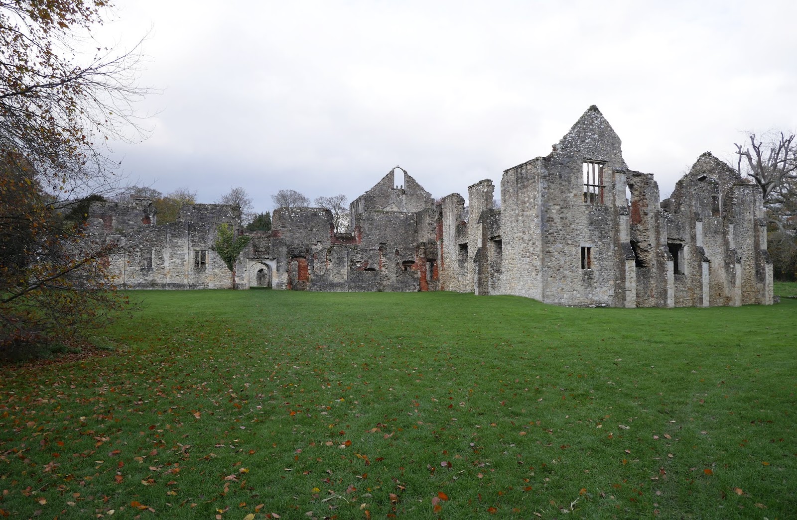
Climbing now you pass the totally overgrown remains of what was once a Norman Motte and Bailey castle. It is no longer really obvious. We did this walk in March 2010 and looking back it is staggering how clear the motte was at that point.


Just beyond it is the church of St Mary, dating mainly from 1612.


After the church there is a wide grassy area with some fine gate posts standing in splendid isolation.  But what of the two sets of gate posts? In fact, as you look around, no less than six sets can be identified. These two (which date from 1663) ...


... and six more further away (four can be found in this photo).


They are, it turns out, the remnants of a mansion built for the first Earl of Craven. Most date from the building of Hamstead Marshall house between 1663 and 1697, though some may be later. The walls and gardens which they gave entry to have long since disappeared since the house burnt down in 1718.

After this we simply retraced our steps.

Map: Explorer 158 (Newbury and Hungerford).

Conditions: bright and cheering.

Rating: four stars
. Always interesting.

Friday 29 November 2019

Moreton-in-Marsh and Bourton-on-the-Hill

The Redesdale Market Hall

Another town-and-country walk with my friend Merv starting from the Caotwold town of Moreton-in-Marsh (note: not the Marsh). The town is essentially linear and we parked near the station and walked south along the wide high street to reach the Redesdale Market Hall, the town's main landmark. This charming building was designed by Sir Ernest George in 1887. I learn from Pevsner that the ground floor originally had an open arcade.

London Road, opposite, has the Mann Institute (1891) with a quotation from Ruskin inscribed over the door: "Every noble life leaves the fibre of it interwoven forever in the Work of the World".


We headed south passing the Manor House Hotel of 1658 and this interesting structure opposite Bourton Road.


I liked this 17th century lintel over another golden stone doorway.


We turned right passing the fire station and the town's new hospital. The building was rather spoilt by the blank square structure projecting from the back.


Soon we had left the town and were heading across very wet and muddy fields. There was at least a nice bit of residual autumn colour to brighten our way.


We squelched our way eastwards to eventually swing north and wander along a drive to reach the A44 and climb the hill to Bourton-on-the-Hill. On the left was the imposing Bourton House, rebuilt in the 18th century.


Just beyond it was The Retreat, almshouses of 1831.


Beyond that was the church of St Lawrence, Norman, but with 12th, 14th and later alterations.


After a dismal lunch in the Horse and Groom Inn we retraced our steps down the hill and turned right at the church to head south across fields towards Sezincote House. There was a lovely wide open view.


The house was closed of course, but the path passed sufficiently close to get a good view. The house was remodeled in an Indian style from about 1805 by Sir Charles Cockerell who had made his fortune working for the East India Company. The interior is apparently classical rather than Indian.


After being driven off the track into a field by flooding we turned left and headed back towards Moreton along a nice firm path. As we got closer we were delighted, Merv especially, to notice these field strips, evidence of medieval farming.


Conditions: a lovely day, but wet underfoot.

Map: OL45 (The Cotswolds).

Distance: about 5 miles.

Rating: four stars. Interesting and varied.

Monday 18 November 2019

Warsash to Lee-on-the-Solent (Solent Way 5)

The Rising Sun

We picked up the Solent Way at Warsash on the opposite side of the River Hamble to Hamble-le-Rice and walked away from the rather inviting Rising Sun pub. A plaque reveals that this was where 3,000 Commandos set sail in landing craft for the Normandy Landings in 1944.

We followed the track towards the mouth of the Hamble: this was the view towards the other side.


This area (the Hook with Warsash Nature Reserve) offered a great variety of bird life - I must must put some time into improving my shoreline bird identification!


Further along, once we were walking along the side of Southampton Water again, we noticed this dramatic structure on the other side: from the map it looks to be Fawley Power Station.


We followed the path until we reached a point where the signage disappeared, just before the Solent Breezes Caravan Park - and so did the path! We found some steps which led up to the caravan park, a strode confidently across it to reach a sign saying the coastal path was closed (but not offering anything in the way of an alternative). After talking to some residents who explained that the problem was (a) coastal erosion and (b) an out of date map (dating from 2005 it turned out).

We found our way down to the gravel beach. This was the very eroded clifftop we had expected to walk on the top of.


This was the view ahead to Hillhead - it looked like a tiring walk.


Happily, after a while we spotted a steep path leading up to the cliff-top path, which was here set back much further from the cliff edge. Now we made faster progress, observing a massive flock of Brent Geese in a truly massive field on the land side.


As we approached Hillhead we were forced inland by a fine house (Dreamfield) whose construction required the path to be diverted inland - again without any signs to get you back on track.


Fortunately, we were able to find our way to the beach where we passed in front of the Meon Shorre Chalets and then round the corner to Hillhead Harbour. Across the entrance to teh harbour we could see a a line of beach huts in shades of blue, looking was nice in the afternoon sun.


Passing the beach huts led to a pleasant walk way with overhanging foliage.


We left Hillhead along the road passing the Osborne View pub, altering us to the distant sight of Osborne House, allegedly Queen Victoria''s favourite.

Further on, we turned right down onto a path at the back of the shingle beach which offered quite a nice sunset.


My final image is this platform in the Solent, presumably for oil drilling or something similar.


After that it remained only to follow the path into Lee-on-the-Solent, where we had parked. We were surprised - and rather saddened - to learn that there there was once a pier with an art deco tower at the back of it. It was built in 1935 and demolished in 1958. The advent of package holidays was blamed for its early demise.

Conditions: bright and sunny for the most part.

Distance: 7 miles, not counting the various detours.

Map: Explorer 119 (Meon Vally, Portsmout, Gosport and Fareham).

Rating: four stars.

Saturday 16 November 2019

Southampton (Town Quay) to Hamble-le-Rice (Solent Way 4)


God's House Tower

We have had a bit of a lull in our Solent Way project - since mid July - but here we are, back on it. We resume at Southampton's Town Quay and turning right from its entrance, we pass the remains of the City's Weest Gate and then reach the 15th century God's House Tower. It was built to protect the sluice gates which controlled the flow of water into the (then) town moat. It was also the headquarters of the Town Gunner. A look at our 2012 City Walk in Southampton revealed that we had in fact come this way before.

We continued along Platform Road and into Canute Road where we admired the plasterwork on this former hotel.


At the end of Canute Road we climbed up to the Itchen Bridge to cross the wide River Itchen (looking into the sun unfortunately).


We walked through the suburb of Woolston, grateful for the frequency and precision of the way markers and emerged on the side of the Itchen. We were struck by the great size of this ship moored on the other size of what is now Southampton Water, fed by the Test and the Itchen.


We headed along Weston Parade where there were four rather lovely art deco pavilions. All the windows have long gone and there was inevitably a lot of graffiti. Such a shame.


At the end of the Parade we continued through Westwood Woodland Park, keeping near to the waterline.


We emerged onto a road and were delighted to find the ruins of Netley Abbey (English Heritage) right opposite. The original Cistercian abbey was founded  in 1238 and granted to Sir William Paulet, Marquuis of Winchester, by Henry VIII after the Dissolution of the monasteries. Paulet demolished the monks' refectory and added a large house. The house remained occupied until 1714, when it seems to have been abandoned as a picturesque ruin. Paulet's additions were removed in the 19th century.

We were surprised by how big it is - this is the first view you get of it.


And beyond the main facade lies a massive cloister and the remains of the church.


We continued along the road through the village of Netley and rejoin the waterside at the entrance to the Royal Victoria Country Park. This was once the site of the massive mid 19th century Royal Victoria Hospital, designed to care for British soldiers who were fighting in sundry wars across the globe in that period. The initial trigger was the appalling conditions of field hospitals during the Crimean War.

The hospital was over a quarter of a mile long and was the world's longest building when it was completed. It fell into disuse after the Second World Wat and was closed in 1958, and burnt down in 1966. All that remained was the imposing chapel.


We walked through the park, keeping as close to the water as we could to emerge on a narrow coastal path passing a oil terminal and a massive jetty. We slightly overshot the correct route as we approached Hamble-le-Rice, but managed to find the right way in the end to reach the Foreshore car park. This is where the cheerful pink ferry goes to Warsash on the opposite side of the River Hamble, the third river to flow into Southampton Water.


Conditions: bright at first, then cloudy. Cool.

Distance: 6 miles.

Map: Explorer OL 22 (New Forest).

Rating: four stars.

Wednesday 23 October 2019

Wantage

King Alfred's School

Another walk with my good friend Merv. In fact it is two walks: a circular walk from Wantage passing through Letcombe Regis, East Challoe and Cove, and a walk around the town itself.

We parked at the Beacon art centre and walked a short way along the road to pass the original King Alfred's School, which dates from 1849–50. From here a path led us towards open country which we crossed to reach the pretty village of Letcombe Regis. We we were very struck by this lovely half timbered house of 1698.


And also by the handsome Old Rectory opposite. I couldn't quite get a photo however. Nearby was the church of St Andrew. The tower is 12th century and other parts were restored or rebuilt in the 15th and 19th centuries.


We followed a narrow track with a lovely view across fields to typical downland countryside.


We turned right onto another track, along a short section of road and then along Cornhilly Lane to reach and then follow the former Wilts and Berks Canal. It was completed in 1810 (so late in the canal era) with the purpose of allowing coal to be shipped from the Somerset coal fields to the towns of Wiltshire and Berkshire. It went into decline only 30 years later with the advent of competition from new railways.

The first section of the canal was dry and required some imagination to recognise it as a canal.  At a crossing road we found this fine old building, we think once a forge but now converted into housing accommodation.


Continuing along the same line, the next section of canal had water in it, although covered by green algae. A new housing estate was just beyond the hedge on the left.


At the end of this section the canal side path was briefly diverted on account of a new housing estate. This did mean we saw a flock of Goldfinches - a lovely sight.

The estate was one of several built on the former airfield at Grove. An emblem of the airfield was this de Haviland Venom, a fighter-bomber introduced in 1951. I have no great interest in aircraft, but I was surprised by how modern it looked. It was only in service until 1962.


We now followed a network of paths through the outer areas of Wantage to reach the area known as the Wharf (the Wilts and Berks Canal once terminated nearby). This was once an industrial area and it was interesting to see that two mill buildings still remain.


We walked up Mill Street passing a set of Almshouses dating from 1868.


At the top of the road we passed the former Town Hall, currently being restored, and entered the oblong Market Place to start our town walk - which we decided to do in reverse order. The detailed route can be found here. The main item of note in the Market Place is the statue of Alfred the Great,  although Merv greatly enjoyed the massive second hand bookshop in a sort of arcade at the far end.


You might wonder there is a statue of Alfred here, and the answer is that he was born in Wantage. The statue was the work of Count Gleichen, Prince of Hohenlohne-Langenburg and was unveiled in 1877. The battleaxe in one hand and the manuscript in the other attest to Alfred's prowess as a warrior (victory over the Danes at Ashdown in 871AD) and to his education and statesmanship.

We headed down Grove Street passing the interesting Georgian Clock House


At the top we continued along the road and then turned right and right again to pass through a housing estate which was suddenly revealed to have the 18th century former stables of Stirlings House tucked away in it.


Now down to Post Office Lane to find the attractive Eagles' Close Almshouses of 1867.


Nearby in Newbury Road were the Stiles Almshouses of 1680. Their founder was Robert Stiles, a merchant ... of Amsterdam.


We then went along Church Street to see the 13th century church of St Peter and St Paul, which was sadly closed.


It was a short walk from there to the Beacon.

Conditions: quite mild, but mainly cloudy.

Circular walk distance: about 6 miles.

The walk route can be found here.

Map: Explorer 170 (Abingdon, Wantage and Vale of White Horse)

Rating: four stars.