Monday 25 February 2013

Manchester


The Midland Hotel

We were at a party in Cheshire yesterday and decided we would add on a trip to Manchester. This is a classic city walk for us: we both know Manchester reasonably well having been then for business, shopping etc., but the city walk offers the opportunity to approach it afresh and really see what is there.

I had, filed away, a walk around the centre of Manchester published in Walk magazine in Spring 2007 and we decided to use that as our basis. It starts from Piccadilly station and we found it easier to park at Manchester Central. This is the former Central station, the terminus for trains from St Pancras, now a conference centre. The brick arches of the car park are a fine sight.

We emerged opposite the Midland Hotel. It designed by Charles Trubshaw and constructed between 1898 and 1903 for the Midland Railway Company.

We decided to join our route at Princess St, so we continued along Lower Moseley St past the hotel to quickly reach the Manchester Central Library. This neo-classical building, presumably inspired by the Pantheon in Rome dates from 1930-4 and was designed by E Vincent Harris. It is currently being restored and will reopen next year. It is undeniably impressive and no doubt wonderful inside.


Next door is the Town Hall Extension, as downbeat a name as you possibly imagine. It is also by Harris and is supposedly an attempt to bridge the (literal) gap between the library and the Gothic revival Town Hall, which we come to next. It dates from 1934 and seems to me to involve a combination of Scandinavian influences, especially in the high pitched roof and dormer windows, and art deco in the relief sculptures on the gable ends. The lower parts of the building are perhaps a bit dull, but the top storey and the roof are very pleasing.


We turned left into Princess St and walked along the side of the Town Hall proper to emerge into Albert Square and the spectacular facade.


The architect was Alfred Waterhouse (perhaps principally famous for the Natural History Museum, although one could also mention the Prudential Building in Holborn, Reading School, Strangeways Prison and Liverpool University among many others) and completed in 1877.

In front is the Albert Memorial.

Other the right is a wonderful Venetian Gothic building which now houses a restaurant.


We walked down Brazennose St towards Deansgate and we delighted to see this fine statue of Abraham Lincoln, having just seen the new Spielberg film.


The statue was created by George Barnard and is a replica of one in Cincinnati, Ohio. It was one of two given to Britain in 1918 by Charles Taft the mayor of the city of Cincinnati and son of President W H Taft to celebrate 100 years of Anglo-American unity. Manchester claimed it on the strength of the well-known support of cotton workers there for the blockade of cotton from the slave states, which Lincoln wrote to acknowledge.

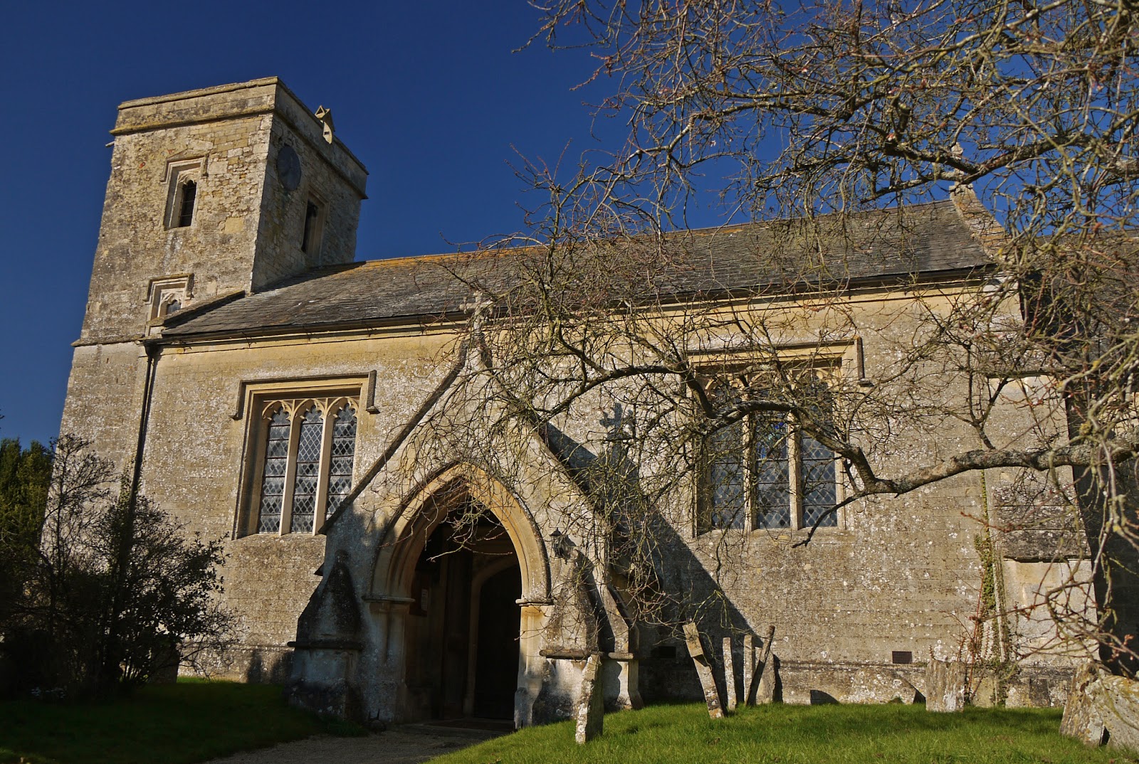
We were then drawn to a side street to see this red brick church.This is St Mary's which unusually advertises itself as "Manchester's hidden gem". This sounds like modern marketing speak, but its website suggests that this name dates back to 1872.


There has been a church here since 1794, but it had to be rebuilt in the late 1830s. Unfortunately for us, a service was in progress so we could see what was hidden within.

Reaching Deansgate we were confronted by the newly restored John Rylands Library, the library of the University of Manchester. It was opened in 1900 and was the work of Basil Champneys. Rylands was a textile millionaire and philanthropist and the library was his wife Enriqueta's memorial to him.


We walked along Dean St, noting the La Vina tapas bar as a promising place for lunch, and turned right to reach St Ann's Sq and the Cotton Exchange, now the Royal Exchange theatre. At one end of the square is the neo-classical St Ann's church of 1712, currently being restored.

One one side of the square is this lovely shop, which looks to have received a very good restoration, presumably by Barclay's. If so, well done to them.


The Royal Exchange itself isn't really that interesting a building, but I quite liked the corner clock and tower.

We walked along new Cathedral St to reach a surprising square at the end. The Old Wellington Inn directly ahead is the oldest building in Manchester, dating from 1552. The Oyster House to the right was rebuilt here following the rebuilding of the Arndale Centre. They make a lovely group.


Going through the square brings you to the Cathedral. Construction of a church on this site dates back to 1215, with major reconstruction in the late 15th century. The external stonework was renewed in the 19th century and there was further rebuilding after bomb damage in the second world war.


Round the back is Cathedral Gardens where the impressive Urbis building dominates one side of the open space. It was designed by Ian Simpson and completed in 2002. It now houses, appropriately enough, the national Football Museum.


We now walked along familiar and not especially interesting streets to Piccadilly station and up Fairfield St to Canal St. We walked behind this splendid Victorian building, and I went round to the front to take this picture, but I still don't know what it is.


Then along Canal Street. If you didn't know the character of this part of Manchester, with its many bars and clubs, some of the names - G A Y and Queer, for example - would soon give you a clue.


This brought us back to Princess St and an easy return to Manchester Central.

Conditions: grey and rather cold.

Distance: we walked about 4 miles.

Rating: four stars. Very interesting. I now feel I have a much better grip on the city is really like.

Saturday 23 February 2013

Brereton Heath to Cranage Hall

The lake at Brereton Heath Nature Reserve

About the walk

We were in Cheshire for a birthday party and staying at Cranage Hall hotel. A study of the map revealed that the Dane Valley Way passes reasonably near to the hotel, so I had myself dropped off at Brereton Heath Nature Reserve, six miles away, with the plan to follow the DVW back.

When I arrived at the Country Park, it was grey and cold and just beginning to snow, and I did question the wisdom of this plan. The Visitor Centre was firmly shut, so presumably no visitors were expected, although in fact there were a surprising number of people at various points around the lakeside, including some very hardy fisherman. I felt in great need of some exercise, so I resolved to carry on.

The route led back up to the Holmes Chapel-Congleton road and across to soon join the drive to Davenport House. The fenced gravel path studiously followed the contours of the hillside to leave the house completely hidden from view. As you leave the grounds you enter the river valley and a small bridge offers the first clear view of the river Dane. This impressively winding stream rises near Buxton and flows into the river Croco at Middlewich.


A tarmaced road led uphill towards Swettenham, with pleasant, if unclear, views across parkland.


At Swettenham, the church is an odd mixture of a red brick tower and chancel dating from about 1720 and a mid-Victorian gothic aisle.


The path beside the church passes a lovely half-timbered house. I was struck by the proportion of vertical beams compared to the number of horizontal ones.


You now descend to cross the Swettenham Brook and climb to reach the edge of the north side of the Dane Valley. You follow this past a couple of farms and then into open country. The snow was still falling and the eerie effect was compounded by the plaintive cries of a buzzard.


A bit further on a heron was stimulated into flight. The route now follows field edges, through a bit of woodland, to approach Tremlow Viaduct near Holmes Chapel. It really is very striking - this view was taken having just passed under it. The snow had mercifully stopped by now.


-->The viaduct consists of of 23 arches each spanning 60 feet or so and stands at a height of 105 feet. It was completed in 1842. The valley is much wider and shallower here and the route follows the winding river on grassy banks until it hits the Knutsford road northwest of Holmes Chapel.
I left the DVW here to walk up the road to the hotel. Once in Cranage, I was truck by the picturesque village hall and later by a group of what could only be almshouses (or at least former almshouses, as one was for sale). The central archway gives it away. Pevsner dates them to 1913 and comments that the village hall is a "very enterprising little job" in the style of Voysey. It is slightly earlier and both buildings bear the initials WOO, presumably the benefactor of both.


Cranage Hall itself dates from 1829 and it seems that the section with the porch was not added until 1932. It was a hospital at the time Pevsner was writing (1971).


Conditions: cold, dry powdery snow. Wet and muddy in places.

Map: Explorer 268 (Wilmslow, Macclesfield and Congleton).

Distance: about six miles.

Rating: three and half stars.

Monday 18 February 2013

London: City west

Apothecaries' Hall

It is a long-standing policy to try to tag a walk on to any visit anywhere, but today was the first time I have added a walk to a business lunch on London. I have been feeling a bit deprived of walking opportunities lately.

I selected a walk from London's hidden walks vol 1 which started near to where I was lunching - in fact at Blackfriars. You leave the tube station and immediately descend into a warren of small streets, many of whose names reflect long-gone uses. The whole area takes it name from the large Dominican (Black Friars) monastery that was here in the middle ages. The first sight was Apothecaries Hall, whose courtyard entrance you could easily pass by. It dates from 1673 and was built on the site of an earlier hall which destroyed in the Great Fire of 1666. The Great Fire is a ghostly presence throughout this walk.

A few more winding street brought me to Wardrobe Place, a charming quiet square built on the site of the King's Wardrobe, a house first used by Edward III to store royal robes. It too was a casualty of the Great Fire.

From here it was a short walk past Wren's Old Deanery to the magnificence of St Paul's.


Nearby, at the entrance to Paternoster Square, stands Temple Bar, a city gateway also built by Wren which once stood in Fleet St at the point where it met the Strand (in the city of Westminster).


It was decided to demolish it in 1878 to ease traffic congestion and the brewer Henry Meux bought the stones and re-erected the arch as a gateway at his house, Theobalds Park. It was much later bought by the Temple Bar Trust from the Meux Trust and re-erected in its current location as part of the redevelopment of the square. It suits its new home very well.

Not far away is the second Livery Company Hall of the walk - Stationers Hall, another post-Great Fire building. I had interesting glimpses of stained glass in the windows on the opposite side. Although the door was open I couldn't however manage even a small peek at it because a private fashion event was about to start.


Further along Warwick Lane you come to another Livery Company Hall - this time that of the Cutlers. I have walked past this wonderful building many times, but never investigated its history. The colour and the use of terracotta strongly suggest a building of about 1880 and in fact it dates from 1887. According to the Company's website, the architect was the Company's Surveyor, T. Tayler Smith. It replaced an earlier Hall which had been compulsorily purchased by a railway company - that Hall had replaced one destroyed, inevitably, in the Great Fire.


In Newgate St is the tower of Christ Church Newgate, a Wren church replacing one destroyed in the Great Fire. This in turn was gutted during the blitz and not rebuilt.


Past the desolate Old Bailey and the large church of St Sepulchre without Newgate, to turn into Giltspur St. On the left is the Watch House of 1791, rebuilt in 1962 after war damage. But who was watching what? It seems that the watchman was guarding the nearby cemetery to prevent robbers stealing new corpses for medical research.


The next thing of note is Cock Lane. London street names are always redolent of history, so perhaps there was once a poultry market here? No, in the middle ages it was the only street licensed for prostitutes. I suppose it could have been worse.

Further along Giltspur St is the celebrated, but rather kitsch, fat golden cherub in a niche on Pie Corner. He marks the western limit of the Great Fire. Some people believed that because the Fire started in Pudding Lane and finished in Pie Corner it was God's punishment for gluttony.

Passing the main buildings of St Bartholomew's Hospital on the right, you enter West Smithfield an unevenly shaped square adjacent to the meat market. The handsome 1702 gatehouse of the hospital is on the corner.


Ahead is an even more intriguing structure, with when I first saw it, a crowd of people being given a guided tour. It is the 13th century gate of the church of St Bartholomew the Great, with a house of 1595 built on top.


The exterior of the church presents an interesting hotch potch of styles, but once entering you understand that it is fundamentally a Norman abbey church, whose nave was destroyed in the Dissolution of the Monasteries, and whose large chancel effectively became the nave of a new smaller church.


Inside it is simply magnificent. For the umpteenth time I regret the damage done to English architecture by Henry VIII. Apparently it was also used in Four weddings and a funeral and I was told by the extremely helpful custodian that it was pleasingly bare today because a film crew from Disney was expected. Much as I love films, I can't bring myself to feel any interest in this.


An interesting feature is that two of the arches of the tower are romanesque, while the other two are gothic, marking it out as transitional between the two styles. High up on one of the corners you can just make out - if it is pointed out to you - a cat carved by the mason for good luck.

Now a brief detour along Cloth Fair where John Betjeman lived and which also boasts, at number 41,  a early 17th century merchant's house which survived the Great Fire. From here you return to West  Smithfield and walk down Little Britain, now a surprising name for a street. Thence to Gresham St, well known to me as I have worked for a client here for about the last 15 years. Much of what the guide highlights in this area is fragments of open space where there were once churches destroyed in the Great Fire, the blitz, or both. I was surprised however  to find the - undistinguished - remains of a Roman fort in Noble St.

I turned left into Wood St when another orphaned church tower stands in the middle of the street. This is yet another Wren church, St Alban, but unusually in a gothic style. It too did not fully survive the blitz. Rather wonderfully, it is now a private house.


The route now leads through the Barbican, past St Giles Cripplegate, founded around 1100, but mainly dating from the mid-16th century. The view from the walkway over the lake shows that this once brash 1960s development has mellowed into a pleasing urban environment.


Now north along Silk St and right into Dufferin St past the substantial Peabody Trust estate. This too has mellowed from its austere late Victorian origins.


At the end you go through Bunhill Fields cemetery to reach John Wesley's chapel and home in City Road. It dates from 1778 and was designed by George Dance the Younger. A statue of the great man stands to left of the forecourt.


The route now leads down City Road past Armoury House, the headquarters of the Honorable Artillery Company, the oldest surviving regiment in the British Army, and the second most senior in the Territorial Army. The building itself looks like a pastiche of a fortified castle and dates, rather surprisingly, from 1735.

This section of the walk has been rather a slog and the long norther detour has not really justified itself. Eventually, I was back in Gresham St in front of the Guildhall, home of the City of London Corporation. It is a wonderful building, built between 1411 and 1440.


By now it was cold and getting dark. I decided I had had enough and forwent the last smallish section of the walk. Maybe another time.

Conditions: bright but cold. 

Distance: about three miles.

Rating: four stars. Some real gems, but could have been a bit shorter. The Great Fire - and to a lesser extent the blitz - still loom large.

From: London's hidden walks vol 1 by Stephen Millar (Metro Publications).

Sunday 17 February 2013

Menmarch Guide Post to Albury (Oxfordshire Way 7)


 Flooded fields by Bow Bridge, Waterstock

After a foggy start, we met up with Merv and Pud to continue our progress along the Oxfordshire Way. The route led initially along a muddy track and then followed a large, damp, open field which skirted the edge of Bernwood Forest, the southern section of which rejoices in the name Polecat End.

We then followed a lane from Park House farm across the the M40, past Baker's Farm and down into Waterperry. The route skirts the village - thus missing the church of St Mary - and the famous Gardens, to pass quite close to Waterperry House. The house is 18th century, but it was mostly remodelled in about 1820. The Venetian window makes an attractive centrepiece.


The next field was extremely wet and muddy and the prospect of the one beyond looked even worse, but we found our way onto a parallel track which passed a delightful thatched cottage ...


... and brought us down to Bow Bridge, over the River Thame. The river had burst its banks in all directions (see the photo at the head of this post) and the water was still remarkably high under the arch of the bridge.


We passed the attractive old Mill and soon found ourselves in Waterstock, passing St Leonard's church. The tower dates from the late 15th century, but most of the rest is the result of a sensitive restoration by GE Street in 1858.


Nearby Waterstock House is now a training centre, but we enjoyed the unusually shaped gothic garden house of 1898 (the year being marked on the leadwork above the down pipes).


We now walked across a golf course to reach and cross the busy A418. Faced with a choice with walking round the edges of a muddy field or following the line of a former railway, we decided to spare ourselves and take the latter.


This brought us into Tiddington from where we followed a pot-holed lane to the edge of the hamlet of Albury where we had parked.

Conditions: bright and sunny, feeling quite warm.

Distance:  6.5 miles. Distance now covered 47.5 miles.

Maps: Explorer 180 (Oxford, Witney and Woodstock).

Rating: three stars.


Sightings

The first snowdrops! And even a few crocuses. How wonderful!