Friday 31 March 2017

Brownsea Island

The landing at Brownsea

Our friends Dave and Chris have just arrived for a weekend visit and it turns out they have never been to Brownsea, so we head off down to Poole Quay and take the ferry to make a quick late afternoon visit.

On the approach we marvel at the size of the lagoon. Reclaimed as pasture in the 1850s, the lagoon was allowed to flood in the 1930s becoming a non-tidal brackish water lagoon offering a sanctuary to a vast number of birds.


We decided to head for the Dorset Wildlife Trust reserve and Dave, having wisely brought his binoculars, unlike me, had a field day with the birds including Avocet, Curlew, Jack Snipe, Godwit ....


I did get a nice picture of a colourful Shelduck, with the bonus of an un-noticed Mediterranean Duck, a new one for me.

We walked back past the church of St Mary (1853-4) although many of the fittings are older, having been brought there from elsewhere. Pevsner is very disapproving: "The church is interesting not as a building, but as a museum." A bit harsh.


Beyond the church is a large grassy area where there was a large (about 20) flock of peacocks. A fine sight.


I enjoyed this close-up of one of the two males.


On the far side we followed a path towards the cliffs, passing a large area of daffodils which had leaves, but no flowers: they are known as "blind".


From the cliff there was a great view across Poole Harbour to South Haven Point.


And that was it. Time had run out and the last ferry was due, so we had to limit our visit to a small corner of the island. But it was still great.

Conditions: bright but cool.

Distance: maybe a mile.

Rating: four stars. A short but excellent walk.

Monday 27 March 2017

Braunton Burrows to Croyde Bay (South West Coast Path 95)

Braunton Burrows and Staunton Sands

We picked up the Coast Path at Sandy Lane car park and continued to walk along a track with the dunes of Braunton Burrows between us and the sea. before very long I had spotted some more Speckled Woods (yesterday's was the first of the year) and a Comma (another first).

We passed through a golf course and emerged onto the Braunton to Croyde road at Saunton. We took an inland detour and were quickly rewarded by the sight of a lone Holly Blue (again my first of the year - as I write this I have just seen another in my garden) soon passing St Anne's chapel (1897), located in a rather lovely wooded setting. According to Pevsner it was intended to be the chancel of a larger church which was never built.


Returning to the road, we took a left which headed down to the car park behind Saunton Sands and headed uphill to rejoin the road. Above us was the imposing bulk of the art deco Saunton Sands Hotel (by Alwyn Underdown, about 1937).


As we climbed, we had our first view of the actual sea since a brief glimpse at Instow two days ago. It has been really strange walking so many miles along the Coast Path without being able to see the sea.


Further up the vast expanse of sand becomes visible, with the sand dunes behind on the left.


We crossed the road and climbed to follow a path along the side of the hill. This felt like the real Coast Path at last. An open path, flowers and grass on either side, views over the sea - and, as a special bonus, absolutely loads of Peacocks. Amazing to think that I saw my first of the year only two days ago. We passed around the headland and passed a building our taxi driver had told us about: a lighthouse-style structure right in the headland being built for some magnate and scheduled to appear on TV next year.


A little further on another modern house was nestling into the roadside. Rather a nice house I thought, but don't they have planning controls around here?


In the background is Croyde Sands, which we soon reached. Our first sight was of strata of rock twisted into what seemed to be right-angles from its original position.


Behind the large sandy beach were some inviting dunes.


We walked across the back of the beach and reached the car park at the far end where we had left the car.


Distance: 5 miles.

Grading: Easy.

Map: Explorer 139 (Bideford, Ilfracombe & Barnstaple)

Rating: Four stars.

Sunday 26 March 2017

Barnstaple to Braunton Burrows (South West Coast Path 94)

The Long Bridge, Barnstaple

Day three of our Coast Path trip and we set off from Barnstaple's handsome Long Bridge in bright sunshine. It may not be as long as Bideford's, but it is older, dating from the 13th century, although since widened.

Immediately we passed a pair of art deco buildings, the one on the right (presumably originally a cinema) was especially impressive.


Further on, at right angles to the river, was this curious structure capped by a statue of Queen Victoria, and now derelict. I haven't been able to discover what it is. To the right is a fine warehouse or grain store.


Continuing along by the river, and still following the Tarka Way as well as the Coast Path, we came upon another former railway station, this one imaginatively turned into a primary school.


Soon afterwards there was another view of the impressive Taw Bridge, which we admired from the other side on the other bank yesterday afternoon.


Soon we had crossed  the road by the bridge and left the town behind. The wide estuary was at low tide again although the river still ran shallowly in a wide arc.


We started to hear and see quite a few birds in this area and were delighted to see a pair of curlews patrolling the shoreline and the shallows.


The first landmark was this fine pub, the Braunton Arms, marked on the map as Strand House.


Here is a further view of the river at low water.


The next section gradually diverged from the river bank and brought us to Chivenor, where all that remained of the railway station was these signals permanently set to go. The station site had been redeveloped as houses.


Now on the left we passed the Royal Marines Chivenor barracks, which seemed to occupy a massive site. We we surprised to see signs on the perimeter wall that security was provided by a private security company. Surely the Marines could handle that? But no doubt it makes sense.

We were no on the outskirts of Braunton and suddenly a new type of environment opened up. This was our first sight of the River Caen, which flows into the Taw.


We followed the right bank of this small river. Off to the right was Braunton Great field. When we drove past it later on we were struck by scattered stone buildings of a very medieval style known as linhays - they made a great sight and I wish we had been able to stop to take some pictures. I now know from Pevsner that the Great is one of the very few remaining fields in the country still farmed on the medieval strip system. The presence of several small waterways gave it something of the character of the Somerset Levels.

There was a diversion in operation and we walked along the top of a sort of dyke with a minor road and a waterway (marked as Drain on the OS map) on our right. It was very flat to right and left.


At one point we spotted a swan's nest on a pile of rushes where a waterway came in from the right. The Braunton Burrows can be seen in the background.


This walkway ended at Crow Beach House and we then followed a stony track up to and into the Burrows. We followed this for almost two miles to reach Sandy Lane car park. It was a bit frustrating to not be able to see the sea or even walk through the dunes as the path was set well back.

I did however see my first Speckled Wood of the year, perhaps a bit earlier than usual.


Distance: 9.0 miles.

Grading: Easy.

Map: Explorer 139 (Bideford, Ilfracombe & Barnstaple )

Rating: four stars. A bit frustrating to not see the sea, and quite a lot of tarmac at first, but some nice elements all the same.

Barnstaple

The Albert Memorial clock

We are walking the South West Coast Path in the area around Barnstaple and I felt the town was worth a walk around in its own right. I also knew there were several almshouses to see. This walk was a combination of seeing the almshouses and following the town's Heritage Trail (but excluding the river bank as that is covered in our Barnstaple to Braunton Burrows walk). I started at the Albert Memorial Clock (1862 - this was quick work as Albert had died only in December 1861).

From here I walked along Litchdon St in search of the Penrose almshouses. I was struck by this fine, but sadly empty, Victorian building with coloured bricks and ceramic and terracotta tiles - Brannam's Pottery of 1886 by W C Oliver.


The almshouses of 1627 are a little further along the street. They make lovely composition with projecting buildings at the ends joined by a colonade with the main entrance in the middle.


You are welcoem to go in to find a courtyard with a water pump in the middle.


I was told that the caretaker was happy to show people the chapel (the right hand building on the street front) and took the opportunity. The lectern from where the Reader read to the almsfolk from the bible is still present along with a lovely plastered ceiling.

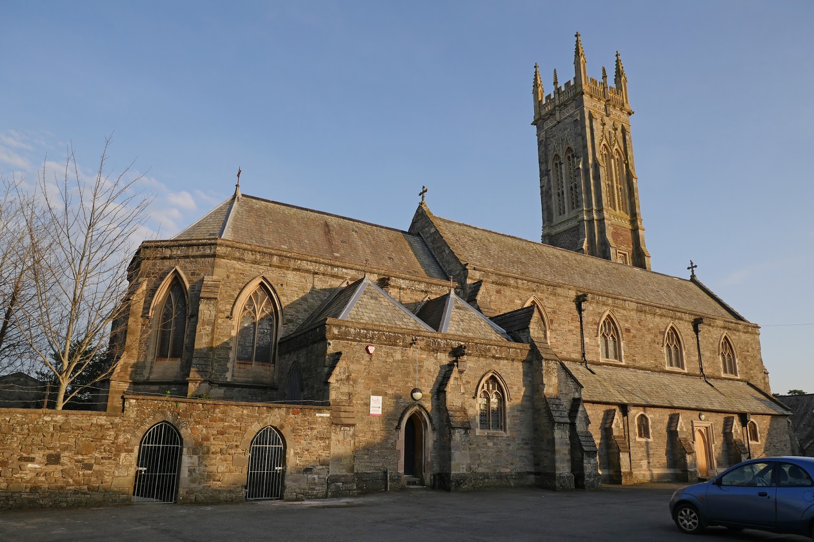
I continued along the street and headed towards the tower of Holy Trinity, a landmark. The church was revealed to be Victorian (1843-5, but partly rebuilt twenty years later). Pevsner describes the interior as dull and I took him at his word and didn't look inside.


I headed back towards the centre of the town along Trinity Street, passing the Salem Almshouses on the right. They were founded in 1834 by Charles Roberts for 24 men and women. There are three ranges, with the street side left open.


Regaining the centre, I headed along the High St, pausing to look back at the imposing 19th century Royal and Fortescue Hotel, where we are staying.


On the opposite corner was a small gift shop with exquisite art deco stained glass in the windows.


On the right of the High St I noticed this jolly building with nice stained glass and a sort of loggia at the top.


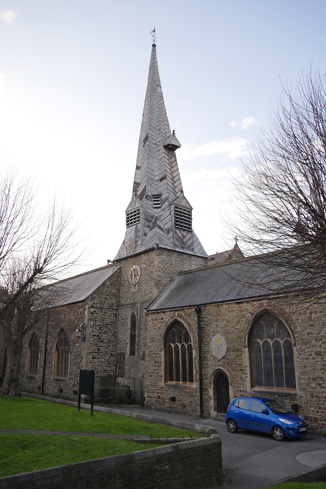
A bit further on I turned to the right to see the church of St Peter and Paul, with its distinctive tower of the late 12th or early 13th century and twisted spire which was added in 1388-9 (Pevsner).


Just beyond it is St Anne's chapel, an early C14 chantry chapel, now a museum. A chantry chapel was one built on private land, or within a church, endowed in the will of a deceased person). They were abolished at the Dissolution of the Monasteries.


Nearby in the narrow Church St were Paige's Almshouses (1656) and Horwood's Almshouses and School (1674 and 1659 respectively)

Returning to the High St, the next main building was the Guildhall (1826 by local architect Thomas Lee, a pupil of Soane and Lang).


Backing straight onto the Guildhall is the Pannier Market of 1855-6. It is 320 feet long. There are well-known Pannier markets in Bideford, Tiverton, Tavistock and Truro - so it seems to be a Devon thing. But what is a pannier market? According to the Plymouth Council website, the word pannier derived from the French for a basket. So a basket market. This wasn't modern enough for Plymouth who have renamed theirs the City Market.


I now retraced my steps down the High St and turned left into Boutport St to quickly be confronted by the art deco cinema of 1931 by W H Watkins of Bristol. The grotesques at the top of the pilasters are by Eric Aumonier.


Beyond the end of Boutport St is North Road and then Pilton Park. I was now in the suburb of Pilton, once a separate town and possibly older than Barnstaple itself (Pevsner). In Pilton St are the attractive Lower Almshouses dating from 1860.


At the top of the street are the Feoffee Cottages and Church Cottages, a very pretty group with the arch in the centre leading to the church of St Mary, founded in the 12th century and once belonging to Malmesbury Abbey. They date from 1849.


I headed back to the hotel along Under Minnow Road, passing the redbrick Lake Almshouses of 1863, and continuing past Pilton Park via Abbey Road.

Conditions: pleasant late afternoon sunshine.

Distance: perhaps 5 miles.

Rating: four stars. A delightful town, well worth exploring.

Saturday 25 March 2017

Instow to Barnstaple (South West Coast Path 93)

Instow seen from Appledore

We sent off from the car park behind the dunes in Instow and followed the edge of the estuary northwards. The tide was out and there was a wide expanse of mud and sand. Now we were in the Taw estuary and looked across to Crow Point which we will pass inland of tomorrow.


Before long there was another spectacularly derelict boat (we saw several yesterday - they seem to be a feature of the area). The grafiti reads "Davy Cameron's offshore treasure map". I am writing this on the day Brexit was declared. It seems appropriate somehow - people who believe in treasure maps are often deluded.


We carried on along a winding trail through marshland which eventually rejoined the tarmac of the Tarka Trail, which had more bicycle traffic than yesterday's section. To the left were several marshy nature reserves.


A bit later, a tunnel of trees provided some variety.


We reached Fremginton Pill (Pill seems to be a local word for a Creek) and a view across to the north bank of the Taw estuary. The stone monument on the left was a memorial to a "local fisherman and character" John 'Dinger" Bell who drowned 30 years ago.


We walked across the former railway bridge and had this view of the Pill with the obligatory derelict boats.


On the other side was the former Fremington railway station now converted into a cafe and doing a roaring trade.


We plodded on towards Barnstaple approaching an attractive road bridge which was soon followed by a cutting.


Here I was delighted to see a  Brimstone and my first Peacock of the year. A sign board revealed that the sides of the cutting were being carefully cultivated to produce a series of colourful flowers. There was a fine showing of Primroses and a few Snake's-head Fritillary (Fritillaria meleagris).


As we reached the edge of Barnstaple, the splendid Torridge Bridge opened in 2007. It is an example of a balanced cantilever design. A rather negative article on Wikipedia describes it as the Barnstaple Western Bypass and expresses worries about the effects on seabirds and the difficulty of reopening the Barnstaple to Bideford Railway.


We completed our walk by crossing Barnstaple's fine Long Bridge (I will use it's picture to head the post of tomorrow's section). It's not as long as Bideford's (yesterday) but is still a great sight.

Distance: 7.0 miles.

Grading: Easy.

Map: Explorer 139 (Bideford, Ilfracombe & Barnstaple )

Rating: Three stars. A bit samey.