Tuesday 31 July 2012

Titchfield

Church Street, Titchfield

We met up with our friends Viv and Giles for another in our series of walks in mid-way locations. Unusually we started with lunch, at the very good Titchfield Mill pub, and then walked through the delightful village of Titchfield. In the middle ages it was a small port at the head of the Meon estuary. It also had an abbey (the ruins of which still remain). The estuary was drained in the 17th century and a canal was dug, but although there are a number of substantial Georgian houses, Titchfield's importance as a port declined in favour of Fareham.

We entered the village via Mill Lane and soon reached the High St, with the Queen's Head pub. We were impressed with its sign depicting Catherine of Braganza, although we had declined the possibility of eating there.


We were confident that she was the wife of Charles II, but less sure of the location of Braganza. It turns out to be north east Portugal and in Portugese is known as Braganca (c cedilla).

At the end of the High St we detoured down Church St (see photo above) for a look at St Peter's church. The lower part of the tower is Anglo-Saxon (9th or maybe even 8th century according to Pevsner) and was originally the porch of a church with a single nave.


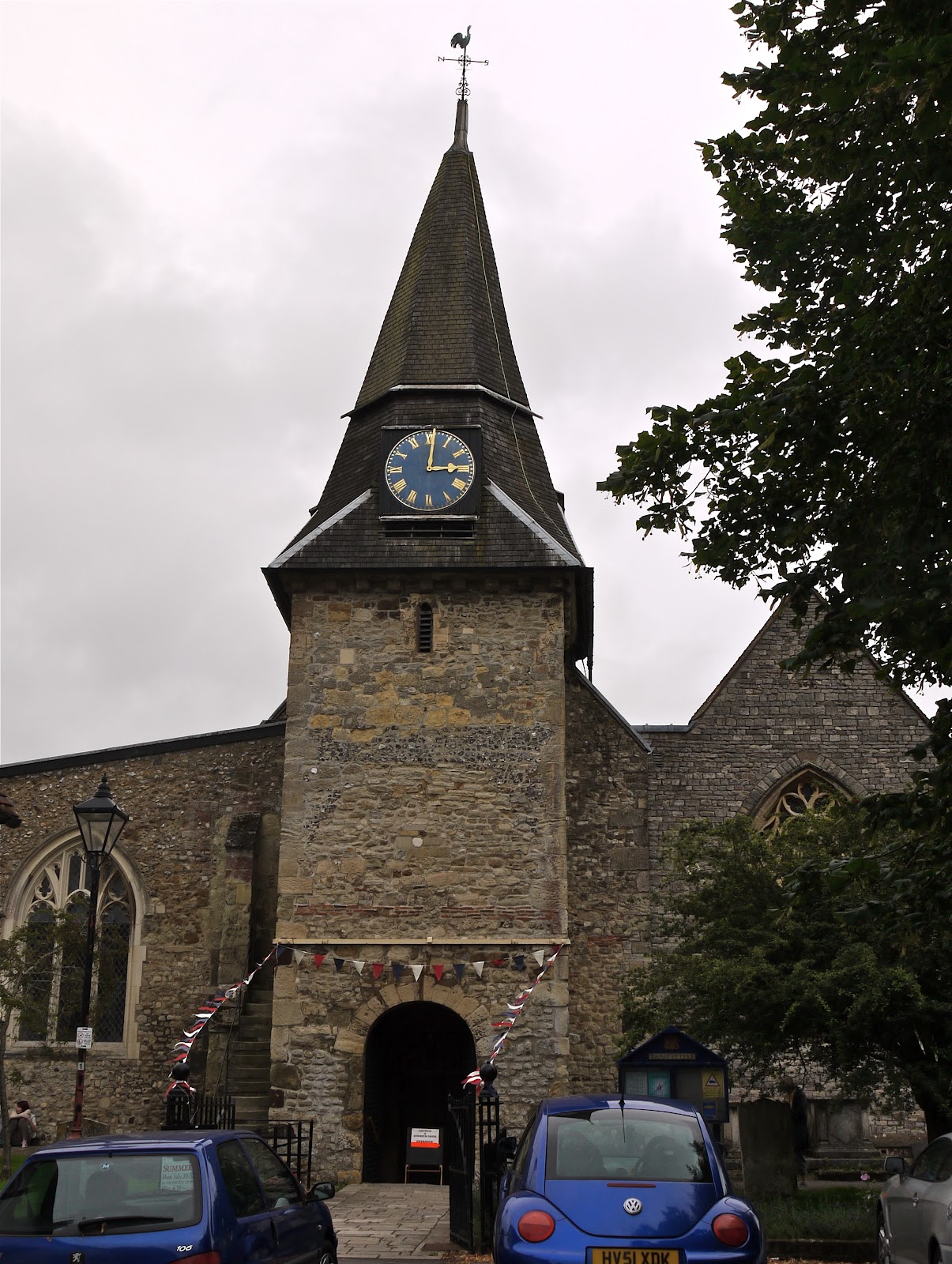
There were significant additions in the 12th to 15th centuries and major changes in the 19th century. It looks rather chaotic from the outside, but pleasantly spacious within.

We continued along South St, past a nice group of half-timbered houses ...


... into Coach Hill and towards the sea along a lane and a series of field paths. We noted a large variety of crops, but largely failed to identify them. Somewhere along the way we were joined by a black and white Jack Russell. Once it was clear that he was here to stay, he was christened Kevin.

Eventually we emerged on the shingle beach, under heavy cloud. The towers of the Exxon refinery to the west suggested some mythical city.


We headed east towards the chalets which mark the mouth of the river Meon, deciding to walk along the top of the cliff rather than struggle through the shingle.


Turner or maybe Whistler might have made a fine tonal work from the intricate shades of beach, sea and sky, with the Isle of Wight on the horizon.


At the chalets (rather ramshackle we thought) we headed inland initially up the road and then along a track with the canal on our left and the river over to the right beyond the reeds of a mature reserve. Before we left the road, our faithful companion Kevin left us. There was some concern for his safety, but the general conclusion was that he probably knew his way around the area better than we did.

The canal was stagnant in places, but after a while it seemed to be refreshed by an inflow from the river and was very pleasant to walk beside.


From: Pocket pub walks in Hampshire by Nigel Vile (Countryside Books).

Map: Explorer 119 (Meon Valley).

Conditions: cloudy, but mercifully the threatened rain did not materialise. Quite warm. Too windy for any flower pictures.

Distance: about 6 miles.

Rating: three and half stars. Interesting and varied.

Sunday 29 July 2012

Littleworth Farm to Kirtlington (Oxfordshire Way 4)

Cornfield near Littleworth Farm

We met up with Merv and Pud to continue our long march across Oxfordshire. The initial stage was along a field-edge path - the Roman road Akeman Street - with a fine cornfield on the right under a wonderful sky. We then climbed a ladder stile (known as Stonesfield Steps) over a stone wall to enter the park of Blenheim Palace.

Initially the path goes between two vast, bare fields, but soon you reach the North Drive to the Palace, with prehistoric earthworks just before. The drive is flanked by a double row of lime trees on each side.

By standing on the top of a gate and using a zoom lens it was possible to get a glimpse of Blenheim Palace, which was built as a gift from the nation to the 1st Duke of Marlborough after his victory over the French in the War of the Spanish Succession.


Further on you exit the park through Wootton Gate ...


... cross the busy A44 and follow Akeman Street, now a metalled road. You then cross a bridge over the tiny river Glyme.


At a T junction Akeman Street becomes a track again and soon crosses Dornford Lane, an ancient green lane. It is instructive to compare the Roman road which crosses the countryside in a classic straight line with the Anglo-Saxon lane which follows the contours to take the path of least resistance.


After another road crossing (the A423) you walk beside more fields with wide views across to the Chilterns, and, today, more great sky.


Soon after this we left Akeman street and soon found ourselves crossing various branches of the river Cherwell. A fairly heavy shower precluded any photography here.

Next we reached Pigeon Lock on the Oxford Canal, completed in 1790 and runs 77 miles from Oxford to Coventry. You can walk the full length.

We were struck by the narrowness of the lock and this was confirmed when a narrowboat arrived and made its way through with literally inches to spare.


We now followed a lane into the centre of Kirtlington, noticing a couple of stone cottages with unusual and attractive brick dressings around the windows and at the corners. Presumably they were late Victorian.


Conditions: warm, but showery towards the end.

Distance:  a bit over 6 miles. Distance now covered 27.5 miles.

Maps: Explorer 180 (Oxford, Witney and Woodstock).

Rating: three and half stars.


Flower of the day

There were noticeably lots of flowers throughout the walk, for example this meadow at the point where we crossed the A423.


Perhaps the most pleasing was this pink one, seen in several grassy fields: Musk Mallow.

Thursday 26 July 2012

Worth Matravers - St Aldhelm's Head - Chapman's Pool

Chapman's Pool

My daughter and her partner are staying with us and requested a taxing walk. This walk, which we did last April as part of our South West Coast Path project, seemed to fit the bill, given the time available.

We started from Worth Matravers and followed the hillside down towards the sea, taking a higher line than last time and ending up at the top of East Man. The hillside was live with Marbled White butterflies - I have never seen so many. I also made my first definitive sightings of the Lulworth Skipper, the smallest and darkest of the the golden Skippers.

This route offered a dramatic vantage point over the quarry workings at Winspit.


During the descent we followed a side track to the Bat Cave. Not the caped crusader, but a sanctuary for the rare Greater Horsehoe Bat. A bit of googling reveals that it can be distinguished from the Lesser Horseshoe Bat by being ... bigger. Which does seem eminently reasonable.


We now followed the cliff-top path, still with many Marbled Whites for company until we came to a rocky outcrop where we saw Fulmars last year. And here they were again, although none would consent to being in my picture.


The next stage involved a climb up to St Aldhelm's Head. Rather than simply repeat last year's photo, I took this one from behind across a cornfield.


The next stage of the walk involves a descent to virtually sea level and a climb to 120 m, in each case by a flight of steps. I hoped this would be sufficiently challenging.

Part of the way down, the view to the west was exquisite, with the rocky end of Emmets Hill on the right and the entrance to Chapman's Pool just beyond.


We now walked along the cliff above Chapman's Pool and took a turning to the right to cross some fields and return to Worth Matravers.

Conditions: sunny, hot, but also breezy, so not uncomfortable.

Distance: just under 5 miles.

Map: Explorer OL15 (Purbeck and South Dorset).

Rating: four stars


Sightings

Apart from the butterflies mentioned there were also Meadow Browns, Ringlets, Large and Small Whites, Gatekeepers and Red Admirals.


Butterfly of the day

It could only be the Marbled White. It was too windy to get a picture today, but here is one I took earlier.


Sunday 22 July 2012

Pamber Forest

The main drive through Pamber Forest

The first nice sunny day for a while and I thought it would do me good to see some butterflies. I looked at D E Newland's excellent Discover butterflies in Britain, but the nearest really promising site was about 45 minutes away. Then I remembered that I had downloaded a leaflet from the Wild Life Trusts website called Great places to see woodland butterflies (one of a series which also includes dragonflies, birds of prey, wildflowers and others). I was staggered to find a site only 9 miles from home at Pamber Forest, near Tadley, promising Silver-washed Fritillaries and White Admirals in the wide sunny woodland rides. It sounded ideal.

A look at the map revealed a long track from northwest to southeast and I developed the simple plan of walking up it. I parked on the edge of Pamber Heath and followed a track at the edge of the village to turn south towards the entrance to the Berks, Buck and Oxon Wildlife Trust reserve. At this point there was a good view across to the Hannington TV and radio mast, a well-known landmark.


The entrance is marked by a barrier and initially there is a gravel track through newly coppiced woodland. Soon you cross an inviting little stream.


And almost immediately I saw the first of many Silver-washed Fritillaries gliding and circling around a clearing to the side of the main track. Yes!!

A bit further on the track became grassy rather than gravelled and I saw a young deer nosing around.


I carried on heading southeast and saw many Fritillaries, Meadow Browns, Ringlets, Large Skippers and a few whites and Red Admirals. But it was not until I was deeper into the forest that the first White Admirals began to appear, mainly keeping fairly high in the trees.

Towards the end of the main track I turned off into a side track into a clearing which was especially butterfly-rich.


At the of the track - a bit over a mile, which had taken about an hour - I essentially retraced my steps. At the upper end I took a right and a left through deeper woodland to return to the car, but the denser woodland meant almost no further butterflies.

Conditions: warm and sunny; muddy in shady places in the woods.

Distance: a bit over 3 miles.

Map: Explorer 159 (Reading, Wokingham and Pamgbourne)

Rating: three and a half stars. Uplifting. There is little to beat a wood or a field full of butterflies on a sunny day. Well done to the Wild Life Trusts for an excellent resource.


Butterflies of the day

A reasonable collection of sightings: Silver-Washed Fritillary, White Admiral, Red Admiral, Marbled White, Large White, Meadow Brown, Small Skipper, Speckled Wood, Ringlet, plus a few dragon flies.

To be honest, I am a bit disappointed with my efforts at photographing today's butterflies - I really must get to grips with my new monopod. Here are the best ones.

A Large Skipper ...


... a Ringlet ...


... and, of course, a Silver-Washed Fritillary.


Sunday 15 July 2012

Granville

Lighthouse at the Pointe du Roc

We had planned an outing to Coutances to see its celebrated Gothic cathedral, but as it was a longish drive from our holiday base in Bayeux, we decided to also see the coast at or near Granville and explore its upper town enclosed behind ramparts. The upper town was fortified by the English when they captured Granville in 1437, but was recaptured by the French in 1442.

When we arrived a market was in full swing and we could not park any where near the entrance to the old town. This was in fact very fortunate as we ended up in the nearly empty car park near the Pointe du Roc lighthouse and were able to embark on a combined coast and town walk.

We followed the clifftop sentier du littoral towards the town and soon had a view of the rocky shoreline, the sea edge of the ramparts and the beach of Domville beyond.


As we approached the town, we passed a gateway near the Notre Dame church and headed round to the right towards the main gate, the Grande Porte, passing under this house with its impressive turrets.


The Grande Porte is not all that grand, but there is still a drawbridge. The plaque over the gateway recalls a siege of 1793.


We now began the tour of the ramparts, initially with views over the port and lower town. At the end of this section you reach Place de l'Isthme. Below the wartime gun emplacements is the trench which the English dug to separate the Roc peninsular from the mainland.


We walked along the seaward side of the ramparts in heavy rain and passed the rather severe church to return to the main gate having completed the circuit. Not the best ramparts ever, but there is a peculiar satisfaction to be had from doing the complete tour. We adjourned promptly to the lower town to get some lunch.

The way back yielded a much more impressive view of the upper town, with its fortified character to the fore.

We climbed up a steep path and retraced our steps past the Grand Porte and under the ramparts. By now the tide had come in somewhat and the port looked much more appealing under a cloudy blue sky.


Further along, we came to a wonderful statue of the celebrated privateer, Pieville-Lepelley.


Privateer sounds much more gentlemanly than mere pirate! Although the distinction is clear in theory - a privateer was given a commission by the state to attack enemy ships in wartime - in practice the boundary was more hazy.

Round the corner we descended to almost sea level to walk around the Point. The coast in the foreground is the continuation of the west coast of the Cotentin, obscuring Mont St Michel, but the Britanny coast can be seen on the horizon.


Further round the Point, the Chausey Islands, the source of the granite from which Granville was built, can be seen, with Jersey to their north west.

Distance: 3.5 miles.

Conditions: cloudy at first, then heavy rain, which in turn gave way to blue sky and sunshine.

Rating: Three and half stars: an interesting combination of town and coast.


Postcript

We went on to Countances. The Cathedral is a very pure, uniform and harmonious Gothic, but not we thought as impressive as the predominantly Norman one of Bayeux.


Saturday 14 July 2012

Bayeux

Bayeux Cathedral

We are staying in Bayeux and, after a morning seeing the chateau of Balleroy and the abbaye of Cerisy-la-Foret, it was time to do a city walk. We had picked up a leaflet describing a circuit around old Bayeux and we joined it at a fairly random point in the north east of the city centre. Our first landmark was the remnants of the former ramparts, now a car park. The house on the right contains one of the towers which was once part of the city walls.


We emerged into rue St Malo to admire the first of a number of fine old timber-framed houses. The statues attached to the facade were especially pleasing.


Then right into rue Franche, with some fine old houses, notably this one: a many sided tower with a square room at the top.


We then looped down to the side of the cathedral and up rue des Cuisiniers to see this magnificent multi-storey house on the corner.


Now right into rue Saint-Martin and across the river Aure. A short detour beside the river reveals this pretty water mill.


Further along the pedestrianised street, thronged with restaurants, we turned right and then through an archway to reach the former seminary which now houses the world-famous Bayeux tapestry.


We went to see the tapestry on our first afternoon in Bayeux and it is truly amazing. Such vibrant images, whose use of colour goes a long way to overcome the limitations of the lack of perspective (not documented until Alberti's On painting in 1435). The audio guide provides an invaluable, if rather brisk, account of the story it tells and highlights some nice details: the spy behind the pillar and the laughing horses on the Norman invasion fleet. It was so good that we went back to the beginning and looked at the 70m tapestry again. Here is just a small taste (the charge of the Norman cavalry at the Battle of Hastings):

For those of us whose main experience of tapestry is of the wall-sized Aubusson tapestries you find in seemingly every chateau you visit in France, the surprising thing about the Bayeux Tapestry is how small it is: only about 19" high. The other surprising discovery is that although commissioned by William the Conqueror's brother Odo (who is seen swinging his mace in some scenes - he was a prelate and so not allowed to shed blood), the tapestry seems to have been made by English craftsmen.

Turning right into rue de Nesmond you soon reach the cathedral (see the photo at the head of this post). It makes a dramatic first impression with its mass, flying buttresses and three towers. The central tower is capped with a green domed "bonnet". The tower dates from the 15th century, but the bonnet was added only in the 19th. My aged Michelin guide describes it as being in "a most unfortunate style". I wonder what Pevsner would have said!

Around the side, the south transept has the story of Thomas a Becket in the tympanum.


The Cathedral dates from 1077, but what you see now is a harmonious mixture of Norman romanesque and later Gothic. We found the romanesque arcade of the nave especially fine.


The oldest unaltered part of the Cathedral is the atmospheric crypt with lovely 15th century reddish-coloured frescoes of angels playing musical instruments.


To complete our circuit, we walked up to Place Charles de Gaulle. Bayeux was one of the first places to be liberated in 1944 and General de Gaulle made  famous speech here at the time: “In our glorious, mutilated Normandy, Bayeux and its environs were witnesses to one of the greatest events in History”.


Distance: no more than three miles.

Conditions: a threat of rain, but generally sunny..

Rating: four stars (five if you include the tapestry as well).