Showing posts with label ridge. Show all posts
Sunday, 31 August 2014
Osmington and the White Horse
It is a nice sunny Sunday morning and so we set off for a circular walk from Osmington. We park near the church and follow Church Road to the north, turning off up some almost invisible steps to walk through the wooded surroundings of the village. We soon emerge into fields and before long have our first view of the famous White Horse.
We first saw it from a distance when we were walking the coast path from Osmington Mills to Ferry Bridge on a murky November day in 2011. It is much more impressive from closer up in the sunshine. It was created in 1808 as a symbol of gratitude to George III for his patronage of nearby Weymouth. John Rainier was the instigator.
The view back along the full extent of White Horse Hill is impressive.
We follow the valley bottom to reach Sutton Poynz, a pretty village which dates its existence back to 987 AD. Poynz was the name of the Norman family who came to own it after the Conquest. The restored Water Mill makes a fine house.
And the pool beyond is charming, fed by a spring at the base of the ridge.
I couldn't resist these beautiful hawthorn berries.
We climbed the path out of the village to reach a delightful combe, Spring Bottom.
From here, we made a diagonal climb up West Hill where I was delighted to find a number of Adonis Blue butterflies. This is a species that I have fancied I have seen before but have never been quite sure. The two key identification marks are the intensity of the blue and the fact that the black veins cross the white wing margins (they don't in other blues).
Now that I have seen some, I am sure that they were the first: the blue really is, as all the books say, distinctively different.
As we went further up the slope a fine view south to Portland and Weymouth opened up before us.
Once we reached the top and headed along the ridge, there was also a good view to the east.
Ridge walking is always wonderfully exhilarating and this was no exception, wide wide views to the wide open country to the north as well as those south to the sea. Eventually, we took a right to head back to Osmington, strung out up the slope of its hill. The sea can just be made out behind it.
Conditions: warm and sunny.
Distance: just over 4 miles.
Map: Explorer OL14 (Purbeck and South Dorset).
From: 50 walks in Dorset (AA books).
Rating: four stars.
Sunday, 13 April 2014
Bryanston to Hammoon (Stour Valley Path 5)
Today we continued walking the Stour Valley Path, picking up the route at Bryanston Village. The first challenge to find our way through Bryanston School. It did offer a nice view back over the village (above).
We also had a good view of the house which was the basis of the school when it was founded in 1928. Richard Norman Shaw built the house in the 1890s for the 2nd Viscount Portman.
Having eventually found our way out of the school - why were there no signs? - we followed the road to the village of Durweston, with the Stour on our right.
The rape field on the left created a dramatic block of colour, contrasting with the bright blue sky.
As we entered the village we saw this old station sign by the local school.
We crossed the A357 and headed towards Stourpaine, passing a rather unexciting mill and under a railway bridge. The defunct line is now a "Trailway".
The church at Stourpaine was quite picturesque: the tower is old, but the rest was by T H Wyatt (whose work we saw yesterday at Spetisbury). The deceptively gentle curve of Hod Hill can be seen in the background.
Walking along the main street of this interesting village, we were very taken by this formal garden on the left hand side. The gate was open, but there was no sign and we were unsure whether it was a public or private space.
Soon we began the ascent of Hod Hill, eschewing the option to make a circuit if its base. On the way up, I saw my first Speckled Wood of the year. The poor thing is lacking an antenna.
Hod Hill was the site of an iron age hill fort and the defensive ditch is still very prominent. It was also covered in the Cowslips can that be seen in the foreground. I was surprised to see a Kite in the sky above. They are now extremely common in the Thames Valley, but I can't recall seeing one in Dorset before.
As you approach the top (143m) of this wide almost flat hill, there are views all around: it is almost a 360 degree panorama. This is the view to the north east.
You can't however see past Hambledon Hill straight ahead.
We descended Hod Hill by the main path, crossed the road and climbed up a steep slope to join a ridge, appropriately enough part of the Wessex Ridgeway. There was a good view north towards Iwerne Minster, with Canford Chase further to the east.
We followed the ridge onto Hambledon Hill itself. It too was the site of a iron age hill fort: were they allies of Hod Hill or rivals? We climbed the tiny pimple which is at 193m its highest point and continued along to the end. It appears to be a cliff edge as you approach, but reveals a sort of lower terrace. When you get down to this, there is another one.
There is a great view down towards the drive of trees which leads to the Manor House of Child Okeford.
Having found a lateral way down, we followed a path then a road into the centre of Child Okeford, where we had refreshments at the village pub before carrying on our way westwards. This led us across fields which offered a view back towards Hambledon Hill, the pimple of the summit could be clearly seen, as could the stages of our descent.
We rejoined the river Stour briefly, crossing over a concrete bridge. It must be admitted that at this point in its life it is not an especially attractive river. We picked up a track heading north and at Ham Hill natural burial ground were diverted onto the route of a railway line which once went all the way to Wincanton. We followed this until we met a road where a right turn led us finally to Hammoon.
Hammoon is a tiny hamlet, but boasts a nice little 12th or 13th century church (St Paul), with a Victorian wooden belfry.
There is also a surprising thatched manor house, much altered over its life. Pevsner dates the bay on the right to the early 16th century and the porch to about 1600. The entrance doorway may be later.
Butterflies
I have decided to add interest to my butterfly spotting this year by noting when I first see each species. Today we saw Peacock, Small Tortoisehell, Small White, Comma, Speckled Wood, Orange Tip, Brimstone. The Comma was also the first of the year.
Conditions: warm and sunny.
Distance: 7.25 miles. Total now covered almost 40 miles - two-thirds of the way.
Guide: The new Stour Valley Path by Edward R Griffiths, Greenfield Books, 1998, but sadly out of print
Map: Explorer 117 (Cerne Abbas & Bere Regis), 118 (Shaftesbury and Cranfield Chase) and 129 (Yeovil & Sherborne)
Rating: four and a half stars. Full of variety and interest. The two hills were a revelation. Much more dramatic than any previous part of this walk.
Thursday, 27 September 2012
Corfe Castle to Swanage
Looking back towards Corfe Castle
We can see Corfe Castle and the Purbeck ridge from our window in Poole and it has been a keen desire of mine to do this walk from Corfe along the ridge to Swanage - and come back on the steam train. The visit of our friends John and Anne provided an ideal opportunity.
We parked in the National Trust car park at Corfe and walked along the road towards the village, then took a left to pass under the railway line and walk along a lane until a path led ahead gradually ascending the side of Challow Hill. The views back towards Corfe were lovely.
Once we reached the ridge, it was straight ahead with views of Poole harbour to the left and looking back to the right you could see the continuation of the ridge through Knowle Hill. I think the hill on the extreme left may be Swyre Head, one of the highest points near the coast at 203m, which we have climbed several times.
As we walked along Allwood Down we began to catch glimpses of the sea in the distance on the right. I made various, not especially successful efforts to capture the view back along the valley between the Purbeck Ridge and the coastal ridge. This was the best of them.
At the end of Kingswood Down the path swings to the right to pass under Godlingstone Hill and Swanage comes more clearly into view. Anne developed a special interested in Ulwell, in the foreground.
The path descends to cross the Studland to Swanage road and we then took a steep path on the left to climb back up to the ridge and pass the Obelisk. I photographed it under better conditions when we first did the Studland to Old Harry walk in October 2010. This time I spotted a plaque that revealed it commemorated the arrival of fresh water to Swanage.
As we walked further along Ballard Down, the dark clouds which had been chasing us for a while finally caught up and it began to rain. Luckily for us, it was heading for Swanage and veered away to the south. We could still see the Isle of Wight ahead bright in the sunshine.
There were fine views over Poole Harbour, the wide sweep of Studland Bay being especially evident.
I had some thoughts of going all the way to Ballard Point, but it was clearly more sensible to head off to Swanage for lunch, so we turned right at the Stone Seat and walked down into Swanage to eat and catch the train back. The rain journey gave us an excellent sense of how far we had walked as the ridge was visible on the right for much of the way.
At Corfe, as we walked back from Norden station to the car park, I took yet another photo of the castle in the fading light.
Distance: 7 miles
Conditions: cloudy, threat of rain but only one shower
Map: Explorer OL15 Purbeck and South Dorset
Rating: four stars. A really enjoyable walk, but it was interesting that that Ballard Down - with sea on all sides - was still the best bit, and must be one of the finest paths in Dorset.
Flower of the day
John identified this pretty yellow flower as a type of Rock Rose.
Butterfly of the day
We saw lots of Red Admirals, many looking absolutely pristine, as if just emerged. This Comma just paused briefly for a photo
Friday, 19 November 2010
Corfe Castle and the Purbeck Ridge
Another foray from our base in Poole. We parked at a lay-by just off the main road underneath the castle and walked up to the village proper to start the walk near St Edward's church. WE should have begun opposite the 18th century Greyhound pub, but in fact we walked round to the front of the church to see the fine 13th century tower with its impressive gargoyles (the rest of the church is Victorian (1859-60) by TH Wyatt in a matching style.
A benefit of this mistake was that we saw the tiny town hall of 1774, which boasts a plaque claiming to be the smallest town hall in England.
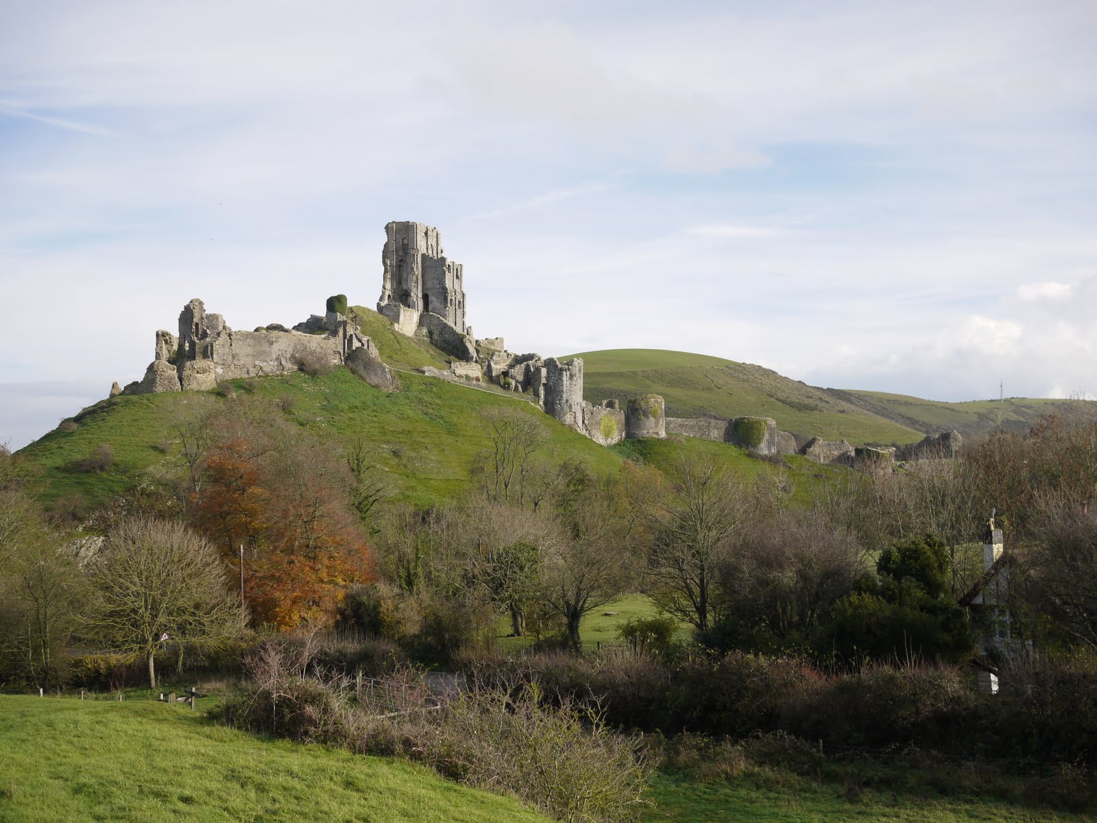
We decided to save a visit to the castle for another day and began the walk by going round the side of the castle mound and descending with it up on out right. The ruins of the Norman keep were clearly visible, as was the line of a later outer protective wall with various bastions. Corfe was a Royalist stronghold during the Civil War and the castle was deliberately shattered by explosives after it was finally captured by the Parliamentarians.
After crossing a lane and then the small river Corfe, the follows the Hardy Way heading upwards to join the Purbeck ridge at Knowle Hill. As it climbs, there are fine views back towards the castle (see above) and later the village, in this case with the smoke of a train on the Swanage railway line in the air above it.
As you walk along the ridge, there are fine views to the south toward another lower ridge, with the village of Church Knowle and its low mainly 13th century church in the valley below. Further on, by moving higher up the ridge views to the north become available: Wareham Forest, part of Hardy's Egdon Heath and Poole Harbour.
After a short dip, the route climbs Ridgeway Hill (168m) where there are further wonderful views towards the sea to the south: St Aldhelm's Head is hidden by the hill on the left.
This marks the edge of the ridge walk. You turn right and and right again to descend along a road through the pretty hamlet of East Creech. After a bit more road you enter Norden Wood, accurately described by our walk book as "exceptionally beautiful". The winding and undulating route also has scattered pools formed from one-time clay pits.
After a mile or so you emerge from the wood to cross a field towards the ridge and the turn left to follow the same line but part way up the slope. This section was the least pleasant for us because it was by now raining quite heavily.
However, the rain mercifully stopped as we emerged from woodland to this fine view of Corfe Castle across open fields.
From: Dorset Walks (Pathfinder Guides)
Map: Explorer OL15 (Purbeck and South Dorset).
Conditions: 10-12 degrees, sun, cloud and rain; wet underfoot.
Distance: 6 miles.
Rating: four and half stars. Great variety and fantastic views.
Sightings
We saw what we think may have been a Hobby hovering effortless at the edge of the ridge. More probably, it was a kestrel.
We also saw a single lone butterfly. It seemed to be a Small Skipper - but maybe it was my first sight of a Lulworth Skipper.
Subscribe to:
Posts (Atom)