Thursday 22 October 2015

Shaftesbury

Gold Hill

We decided to stop off in Shaftesbury while on the way to Poole. A once great town, founded by King Alfred, with an abbey, a castle, 12 medieval churches and no less than four market crosses, it is now principally known for Gold Hill and the views from its hilltop site 215m above sea level. I found this walk on the ever-reliable AA website (although it could have done with a map).

We started at the Tourist Office on Bell St and walked down the road to turn left into Mustons Lane opposite this unusual pair of cottages with stone first storeys and brick second.


On the left is the former handsome Congregational church of 1751, now a pizza restaurant.


At the end a right leads up High St to St Peter's church and the Town Hall.


This is the only remaining medieval church, although like most it has been subject to alterations through the ages. Inside is disconcerting at first with a modern boarded floor and individual modern chairs rather than pews. The effect is more like a village hall, but there are a lot of chairs so no doubt it is thriving.

The Town Hall dates from 1826 in a sort of tudor style and was built on the site of the former Guildhall. Pevsner is quite disparaging ("not at all grand, or even dignified"), but we found it charming. Alleys on either side of it lead to the top of the much photographed Gold Hill, used by Ridley Scott as the site for his famous Hovis advertisement. The initial view is dominated by the massive former abbey walls and spoiled by two parked vans, necessitating the rather compressed photo at the head of this post.


It is remarkably picturesque even so. But much smaller than expected and not as hard on the knees as the walk description would have you believe. At the bottom a left turn leads after half a mile or so to a grassy area known as the Wilderness and path through this leads to fields and excellent, if hazy views southwards to


The route now follows the narrow French Mill Lane, which becomes progressively sunken.


At a junction a right turn into Gascoigne's Lane begins a mainly uphill trudge back towards the town. There are pleasant views to the west and it makes fro more of a walk than simply having a quick look round the town centre. And we spotted this classic, and increasingly rare, flat-roofed 1930s house with an extraordinary, but wonderful, modern extension.


A little track at the top leads round to St James's St, with pleasing two-storey cottages and houses on both sides. It felt like you were entering a separate charming small village. There were too many parked cars however for a worthwhile photo.

Suddenly on the right you come to Pump Yard, a delightful little group of what were once weavers' cottages. It was an enclosed space until 1862 when the front section was pulled down.


A right turn and a steep climb brought us to the view point at Park Walk. The cloud was quite heavy, but the sun suddenly emerged off to the west, illuminating the tree in the foreground and silhouetting St James's church off to the right.


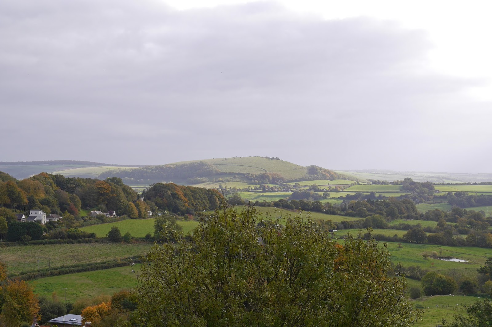
Looking more to the left provided this view of the briefly sunlit Melbury Hill.


We now headed across to visit another fine viewpoint at Castle Hill, from which you can apparently see Glastonbury Tor if conditions are right. Not today unfortunately. We passed Ox House in the strangely named Bimport. The house is 17th century and featured in Thomas Hardy's Jude the Obscure as Old Grove Place.


Now past the abbey ruins and garden. The abbey was, like the others, dissolved by Henry VIII in 1539, but this one was almost totally destroyed. Finally, we followed Park Walk back into the town centre and turned left into The Commons, passing the imposing Grosvenor Hotel of 1826 with its Tuscan columns, to return to Bell St.


Conditions: mild but cloudy.

Distance: 3 miles.

Rating: four stars. Interesting and varied. It would no doubt be even better on a clear day.

Tuesday 20 October 2015

Marlborough to Avebury (Wessex Ridgeway Wiltshire 1)

 Marlborough High St

Having finished the Ridgeway with Merv and Pud, we were faced with the question of what to do next. The Wiltshire section of the Wessex Ridgeway (Marlborough to Lyme Regis) presented itself as the obvious candidate. We started from the east end of Marlborough's long, wide High St. There was a great fire in Marlborough in 1653 and there is no real domestic architecture older than that; most of the most characterful houses along the High St are Georgian.  The handsome Town Hall dates only from 1902 in a sort of 17th century style.


We headed west along the High St and turned right into Hyde Lane to follow this narrow, but criously busy lane away to the north west. This led us to the road to Broad Hinton and then to Barton Down. Here we took a left to join a track running beside gallops across the Marlborough Downs. This was the view back to the east.


This was a wonderfully wide open and quiet section, with vast views in all directions. The most promising views unfortunately were straight into the sun.

After a couple of miles of this, we reached Fyfield Down, which described itself as one of the most important geological sites in the whole country. Although we are nit really qualified to judge, this did seem a bit excessive. There were however immediately some sarsen stones (carried to their present resting places by long ago glaciers.


A little further on, on the left, there was an immense concentration of them.


Now there was a bit a climb to pass Delling Copse with this lovely view back in the direction of Marlborough.


Shortly after this we crossed the final section of the Ridgeway, heading towards Overton Hill.


There was more lovely open country to the north.


We passed Manor Farm and descended on a hedged path to suddenly find ourselves on the edge of Avebury. We took a path on the left which brought us out on the top of the surprisingly large earth work which surrounds the celebrated stone circle.


And a bit further on there was the great sight of at least some of the extraordinary standing stones. Without a detailed map it is perhaps difficult to understand exactly what you are seeing, and it is made more complicated by the fact that the tiny village including a pub favoured by bikers is partly within the earthwork ramparts.


We didn't have time for a proper exploration, but I can now say, courtesy of Pevsner, that the bank and ditch enclose an area of 28 acres.  The English Heritage website says that site dates from the Neolithic period, roughly between 2850 BC and 2200 BC, and there was originally a giant outer circle of about 100 stones - which in turn enclosed two smaller stone circles.The stones were undresssed sarsens. Some were broken and used for building in the 18th century and some part of what you see today was the result of the purchase of the site in the 1930s by Alexander Keiller who bought the site and cleared away buildings and re-erected many stones.

We had parked in the Avebury car park and it was just a short way from the stones to there.

Distance: 6.2 miles.

Conditions: bright and quite warm, maybe 14 degrees.

Map: Explorer 157 (Marlborough & Savernake Forest).

Rating: four and a half stars. A lovely walk between two great places.

Monday 19 October 2015

Cheltenham


Municipal Offices, The Promenade

Cheltenham offers guided walks, but unlike many towns and cities doesn't seem to offer a self-guided heritage trail, which is rather disappointing. I found this walk on the Ordnance Survey website, but it turned out to be pretty awful with unclear directions and a focus on parks rather than the Regency architecture that the town is famous for. Clearly I should have done more research and developed my own walk as I have done in other places!

We started at the Town Hall in Imperial Square and had a quick look at the pleasant 1930s gardens laid out behind it.


We then went further along Oriel Road than we should have in search of Trafalgar Road (correctly Trafalgar St), but it did bring us to the lovely Oriel Lodge of 1825, said to be the earliest gothic style building in the town.


Then down Trafalgar St to find Montpellier Gardens, with some nice autumn colour.


On the far side was one of the original Montpellier Spa of 1817 (extended 1827).


Now back along Montpellier Terrace to the junction with Bath Rd where the former chapel of Cheltenham College (later used as a dining room) can be seen on the opposite corner. The College was founded in 1841.


Our route now took in a poorly described meander towards Sandford Park. We ended up instead in Keynsham Rd where we were delighted by the newish-looking county Fire and Rescue Headquarters.


We entered the rather nondescript Sandford Park further along Keynsham Rd and walked across it, and followed College Rd and Berkeley St to reach Albion St where I knew I would find Cheltenham's only almshouses, Pates. Originally founded in 1511 on the High St by Richard Pate, they were rebuilt here in 1811.


We then took a left to reach the High St and were delighted to spot this art deco upper storey.


From here we wandered along a leafy shopping street towards the Promenade and were surprised and delighted by this statue. It is the Hare and the Minotaur by Sophie Rider and was apparently bought by public subscription after a temporary exhibition of the artist's work.


After passing the magnificent terrace shown in the photo at the head of this post we returned to where we had parked, outside another fine Regency terrace, with classic wrought iron railings.


Conditions: not cold, but pretty grey.

Distance: about 3 miles.

Rating: three and a half stars. We saw many interesting things, but overall it was a bit of a missed opportunity. I don't think this walk really did Cheltenham justice. We also ran out of time to see the Pittville Pump Room.

Thursday 15 October 2015

Bristol: the Old City

Bristol Bridge

I have long planned a walk around central Bristol to see the numerous almshouses and I was delighted to discover this wonderful heritage trail around the Old City. It follows the line of the original city walls and starts from Bristol Bridge. It was designed by the well named James Bridges and built in 1763-68. We decided to do a melange of the two.

We immediately departed the route of the Old City walk however to head south to the superb King St, where the St Nicholas with Burtons Almshouses are to be found on the corner with Queen Charlotte St. They date from 1652 and were extended in the 19th century and restored in 1961. They are now student accommodation.


King St is full of interesting buildings, including the Bristol Old Vic and at the far end is another fine almshouse: the Merchant Venturers of 1699, intended for seamen as the plaque suggests.


The front view is delightful although it was originally a square, partly destroyed by wartime bombing and further constrained by road realignment. It is now private accommodation.


We returned to King St and carried on to enjoy lunch at Loch Fyne in the ground floor of the Old Granary, a fabulous building of 1869, once Wait and James's Granary, in the Bristol Byzantine style.


Suitably fortified we retraced our steps and rejoined the Old City walk at St Nicholas St, to be very quickly delighted by this wonderful drinking fountain on the rear of the undistinguished Market Hall of 1848. It was installed to celebrate Queen Victoria's 40th birthday in 1853. The beam of sunlight enhanced it beautifully.


Further along the street you lass the one time Bristol Stock Exchange and continue along the extremely narrow Leonard Lane, leaving it briefly to explore St Stephens St and St Stephen's church with its tall, slim tower.

Leonard Lane continues into Bell St, where you find St John;s church and the North Gate. An unusual feature of early Bristol was that there were five churches built on the walls, with gates under the church towers. I have never seen this arrangement before - shown below from the outside. In the city of Banksy, I suppose it is not surprising to find extravagant images on the ends of the adjacent office blocks.


Now it was time for our second side trip. We crossed the busy Colston Avenue and went to see St Bartholomew's Hospital at the bottom of Christmas Steps. It is a 12th Century town house incorporated into monastery hospital founded 1240 by Sir John le Warre, and later a school. All you can see now is the handsome gateway. A sign revealed that it was now apartments, all sold.

At the top of Christmas Steps is the dramatic Foster's Almshouses, originally founded by a bequest from 15th century merchant John Foster in 1492, but all too obviously high Victorian. The present buildings were constructed between 1861 and 1883 and are now private apartments.


Nearby, in St Michael's Hill, we passed these cheerfully painted old houses ...


... on our way to see the harmonious Colston's Almshouses, built in 1691 (and restored in 1861 and 1988).

After a quick look at the less impressive Bengough's Almshouses (1878) in Horfield Road, we returned down Christmas steps to rejoin the walk route at St John's church. We walked along Broad St to be immediately confronted by the simply marvelous Edward Everard Printing works, one of the very few all-out art nouveau buildings in England.


The architect was Henry Williams and the facade was designed by W J Neatby, the chief designer of Doulton (now Royal Doulton) whose tiles were used to cover the facade.


Almost next door, in a narrow court, is the one-time headquarters of the Merchant Tailors Guild, established in 1399. It is now appartments, but the crest remains over the door.


Also in Broad St are the Guildhall and Assize Courts, a branch Bank of England and the Grand Hotel, of which only the latter still carries out its original function. At the end there is a junction with the other three streets which define the old city: High St, Corn St and Wine St. Christchurch (rebuilt in the 18th century) stands on the corner and the High Cross, erected to mark the charter of 1373 which gave Bristol city status, stood in the intersection. It was removed in 1733 after a public petition, but can still be seen at Stourhead in Wiltshire.


The start of Corn St offers the neo-classical Old Council House, now the Register Office, and a very ornate bank building next door.


Almost opposite is the The Exchange of 1743, a grand building now somewhat diminished as a covered market, albeit a very popular one.


We completed our walk by going a short way along Wine St to see the church of St Peter, one of the oldest in Bristol. It was badly damaged by bombing during the second world war. It is a poignant reminder, like the Charles Church in Plymouth or the ruins of Coventry's old cathedral.


Conditions: generally bright and sunny.

Distance: about 4 miles.

Rating: four and a half stars. Very rewarding. Maybe only four stars if you are not interested in almshouses.