Wednesday 25 June 2014

Fernhurst

St Margaret of Antioch, Fernhurst

We met Viv and Giles in Fernhurst for our latest walk and headed towards Black Down, soon passing the village church. It is a very picturesque church with a late Victorian look about it, but strangely not described in my early edition of Pevsner's Surrey. From the church's website I learn that it is Norman in origin, but what you see now is mainly indeed a Victorian restoration by Antony Salvin.

Church Road emerges into the village green with a collection of pleasant houses, a pub and a cricket pitch across the road.


We take a path just to the right of the pub and head upwards through Reeth Wood to emerge by a house called Reeth. On the way we help a group of boys, identically kitted out with haversack, sleeping roll and wooden staff to orientate themselves towards Cotchet Farm.


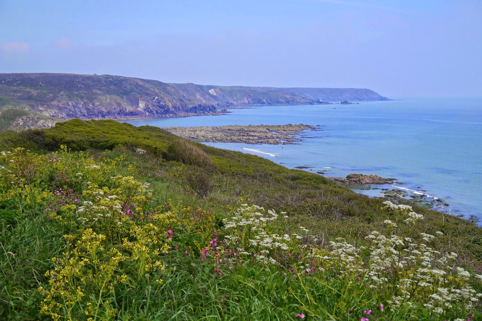
We walk along the lane from Reeth enjoying the fine views across open country, looking South West towards Henley (where we plan to have lunch) and further west to the South Downs in Hampshire.

At the end of the lane we resume our climb up a narrow track which eventually becomes a stream bed to reach what we thought was the viewpoint marked dramatically on the map as the Temple of the Winds. It is more wind than temple however, at a height of 275m above sea level. It appears we never quite located the marker for it. We found a bench with a strange plaque: "Bonnett, Braithwaite, Bennett. La Di Dah". The view from the bench towards the South Downs, framed by foliage, is delightful.


After a while we realised that there were other views accessible by crossing through a bit a woodland and then following a path around the hill top back to the bench we first encountered. This view stretches north east to Leith Hill, where we walked five years ago. I am surprised and delighted that this series of walks with our friends goes back so far.


Part way round there is another view point where the view extends to the Arun gap.


By now the lunch booking at the Duke of Cumberland Arms pub in nearby Henley was beginning to become pressing and we headed rapidly back to the cars. The pub was one of the top 50 Gastro pubs last year, as assessed by the trade paper the Morning Advertiser, and was excellent. We plan to design our next walk around going back there.

Conditions: cooler than of late, but still quite warm.

Distance: about 4.5 miles.

Map: Explorer 133 (Haslemere and Petersfield).

Rating: four stars, principally for the divine views.

Wednesday 11 June 2014

Porthleven to Praa Sands (South West Coast Path 58)

Porthleven

We started today's leg by simply walking out of the pub where we have been staying and following the edge of the harbour. This gave us an excellent view of the wonderful Bickford Smith Institute at the start of the breakwater.

We made the inevitable climb out of Porthleven and enjoyed the view back along Porthleven Sands, i.e. yesterday's route.

A flat grassy section overlooking rocky ledges, gave way to a curving sweep of coast with several small inlets.

The route along here was up and down and as we entered a more over grown area we found ourselves engaged in quite an arduous climb to the top of Trequean Cliff. This led into Trewavas Cliff where we reached the former mine workings that we had seen across the bay. Wheel Trewavas has been restored by the National Trust and now presents a rather picturesque image just below the top of the cliff, high (well 60 odd metres) above the sea below. No doubt it was anything but picturesque to work there!


We now turned a wide grassy headland and descended towards Porthcew, also known as Rinsey beach. This pleasant sandy cove has a high grassy cliff at its back where another restored mine can be seen. This is Wheel Prosper. A helpful sign board explained that it was not in fact a success story and operated for only a few years before being closed. It did feature however in the once famous TV series Poldark.


We walked past Wheel Prosper and along a path somewhat back from the coast to soon be greeted by the great sweep of Praa Sands.


As we got closer, the headland of Prussia Cove and the other side of Mounts Bay could be seen beyond How Point which marks the end of Praa Sands. 


Praa Sands was the end for today because we were leaving the path to visit distant relatives who live there. On the way inland we were staggered to suddenly come on a castle by the side of the road.


This is Pengersick Castle, described by Pevsner as a "remarkable and important survival". He explains that it once formed part of a larger mid 16th century fortified manor, probably built by William Worth, of Worth in Devon.

Conditions: warm and sunny.

Grading: Strenuous becoming Moderate.

Distance: 5 miles (distance now covered 347.7 miles.

Map: Explorer 103 (The Lizard) and 102 (Land's End).

Rating: four stars.

Tuesday 10 June 2014

Mullion Cove to Porthleven (South West Coast Path 57)


Mullion Harbour


We set out from Mullion harbour, which offers a great view out to sea with Mullion Island and the great rock called The Vro to the right and left respectively. We climbed up to the cliff top and soon had a view of Polurrian Cove beyond a jagged rock.


A bit further on we encountered the Marconi monument.


The first transatlantic radio transmission was sent from the nearby Poldu radio station in 1901. The memorial was erected by the Marconi Company in 1937 soon after the station was demolished. Poldu was chosen initially as a remote location which would prevent Marconi's experiments gaining any press or public attention.

As we turned Poldhu Point, a new coastline opened up with larger, less rocky coves than we had seen before and more sandy beaches.


The first of these was Poldu Cove (why the different spelling?). Ange had fond memories of coming here as a child and it seems little changed. We walked round the back of the beach and climbed up the other side back onto the cliff to find our way round to the strangely named Church Cove.


According to Pevsner (using the excellent newly published revised second edition of his volume on Cornwall) the church of St Gunwalloe probably dates from the 13th century, and was rebuilt in the 14th and 15th and restored in the 19th. It is a remarkably picturesque location.

The adjacent Gunwalloe beach was a much more rocky affair.


We turned a headland to walk along Halzephron Cliff. It was dark and gloomy now and coming on to rain. By the time we reached the start of Porthleven Sands at Gunwalloe Fishing Cove, it was quite wet, but the long sandy expanse stretched impressively away from us. It seems that it is dangerous to swim along here and no doubt this explains why it is so underdeveloped.

Once we were about halfway to Loe Bar the rain had stopped and I took this view back into the sun.


The next major milestone was Loe Bar, where a wide mound of sand and shingle separates the sea from Loe Pool. This was a ria, or drowned river valley - a geographical feature we have met a few times on the South West Coast, notably at Helford and Kingsbridge . It is now Cornwall's largest freshwater lake into which flows the River Cober. The bar seems to be at least 700 and possibly many thousands of years old.


Another mile brought us to Porthleven, where the waves were already high enough to create some spray off the end if the breakwater.


We walked along by Porthleven's well-defended harbour: apart from the breakwater, there is an outer harbour and giant planks are apparently used to close the mouth of the inner harbour. These were not proof against February's gale force winds.


This is the view from the end of the harbour. The imposing building in the distance is the Bickford Smith Institute built in 1882 as a scientific institute and library. It is now the Town Hall.


For the third day running we saw a Peregrine - in fact today there were two sightings, one at Poldu Cove and the other above Portleven Sands. I also saw a Large Skipper for the first time this year. 

Conditions: warm and reasonably sunny, with a period of rain in the middle.

Grading: Moderate.

Distance: 7.1 miles (distance now covered 342.7 miles).

Map: Explorer 103 (The Lizard).

Rating: four stars.


Monday 9 June 2014

Lizard Point to Mullion Cove (South West Coast Path 56)

 Looking out to sea from Lizard Point

We arrived yesterday afternoon in rather grey weather at the rather dispiriting collection of shacks that mark the Lizard Point, the most southerly piece of land in England. Today however, the view out to sea is very inviting. The apparent carpet of Hottentot Fig in my picture is, I must confess, the top of a wall. I suppose one should be opposed to invasive species like this, but it is very attractive.

I looked in a little shop which was selling items made out of local Serpentine. This is a hard rock found only in a few scattered places across the world. We learned from our taxi driver that it is becoming increasingly hard to find pieces of Serpentine which are rewarding to sculpt and that the number of people who have mastered the art is dwindling. He mentioned that a lighthouse is a favourite subject for a Serpentine sculpture and the shop certainly bore this out with shelves of lighthouses of different size.

As we climb away from the Lizard we look down on the old Lifeboat Station - we passed the new one yesterday.


And then head along the wide grassy headland you can see on the right in the picture. Signs warn us that Cornish Choughs (a red beaked member of the crow family) are nesting. And sure enough, a glossy pair immediately appeared. After a rocky headland, a curving bay opens up and the white buildings of Kynance Cove can be seen in the distance. 


After a while, there is a steep descent and ascent at Caerthillian Cove.The path on the right descends from the bottom right hand corner. There were some entertaining Gannets flying around and diving into the sea like Terns.


When we reached the top on the other side, there was an especially good example of a traditional Cornish hedge. Yes, not your normal hedge, but a wide stone wall covered in earth and flowers, commonly Thrift.


We walk along a high cliff until it is time to descend to the extremely picturesque Kynance Cove. The tide is in, so we can't see the lovely white sand. We take refreshments at the cafe, along with many others including a massive coach party of Germans.


We climb now onto Kynance Cliff, a rather desolate high plateau which is part of the Lizard National Nature Reserve.


At Soap Rock there is another sharp descent and ascent. We found this section of the walk rather a trial: you are walking at the edge of a high plateau, there is low vegetation, few flowers, not many birds, no butterflies. The most interesting thing we saw was a helicopter practicing hovering in the distance.

It was very striking that when we left the reserve, the hedge was much more alive with life, as was the next field. I was thrilled to see a second Peregrine falcon majestically gliding above (I saw one yesterday as well).

A new section of coast starts at the rocky Men-te-heul. Mullion Island dominates the foreground, with Mullion Cove hidden behind the enormous rocks on the right. Further away the peninsular begins to flatten out as it heads towards the mainland.


As we approach Mullion Cove, we can see that Mullion Island is in fact a three-legged shape, rather than the rectangle it first appeared to be.


Continuing along the cliff top, we soon have a fine view of the Cove, where some harbour repairs are evidently underway, dealing with damage caused in the February gales.


It remains only to walk along the grassy cliff and wander down to the back of the tiny harbour.

Conditions: warm and mostly sunny.

Grading: Moderate.

Distance: 6.8 miles (distance now covered 335.6 miles).

Map: Explorer 103 (The Lizard).

Rating: four stars.

Sunday 8 June 2014

Kennack Sands to Lizard Point (South West Coast Path 55)


We resumed the Coast Path on a mild but cloudy afternoon and headed onwards from the cliff-top car park above Kennack Sands, where we stopped last month. It became dark and gloomy as we entered a National Trust area called Poltesco. A fine new footbridge with curving sides enabled us to cross a ravine.

When we reached Enys Head things had brightened up enough to take a view back, enriched by one of a few grazing ponies.


The view forward stretched as far as Bass Head. 


The cliff-top path soon brought us to Cadgwith Cove, with some lovely thatched houses and some substantial rocks jutting out into the bay. 


On the beach there were a surprising number of fishing boats and a very inviting shop selling their fresh catch. With a couple of pubs as well this was definitely our kind of place!


 We climbed to soon reach the Devil's Frying Pan.


Why? Oh well, who cares? It is apparently a collapsed sea cave. But soon after, I was delighted to see my first Small Skipper and then my first Meadow Brown of the year. Now there was a clearer view towards Bass Point.


And before long we reached the Lizard Point Lifeboat station. This featured an unusual funicular railway to link the cliff-top to the boat house.


Round the corner from Bass Point where a Coast Watch station took the place of a former Coastguard one the castellated building we had seen from afar could finally be identified. It turned out that it was the former Lloyds Signal Station. It dates from 1872 and was erected by Falmouth Shipping agent. It communicated with ships by semaphore and relayed their news onwards by telegraph. A thousand ships a month were using the facility five years later, according to Pevsner. 


Next we passed the Lizard Point Marconi Radio Station, just a pair of timber-framed huts, where a record for wireless transmission was established in 1901 when a signal was successfully sent to the Isle of Wight 186 miles away. We enjoyed the view across Housel Bay to the Lizard Lighthouse. 


The lighthouse is the oldest mainland lighthouse in Cornwall: the towers were built in 1752. The final stage requires a steep descent and ascent while traversing Hounsel Bay and the path then goes under the lighthouse and round to Lizard Point. The first sight is rather downbeat: a collection of huts straggle along the headland.


Today's dominant flowers were Red Campion and Sea Kale, with quite a lot of Thrift. At various points we saw Fulmars gliding by the cliff tops.

Conditions: warm, but quite hazy.

Grading: Moderate.

Distance: 5.5 miles (distance now covered 328.8 miles).

Map: Explorer 103 (The Lizard).

Rating: four stars.

Friday 6 June 2014

Noar Hill: butterflies and orchids

 Common Blue

It's been a hectic week in the garden, the sun is shining and I decided to bunk off for the afternoon to try to see some butterflies at Noar Hill. Why do I feel the need to justify this? I fairly quickly spotted a couple of Small Blues and a few bright Common Blues, and a smattering of others - Orange Tip (male and female), Brimstone, Large White, Small Heath, Speckled Wood at the edge of the grassy area.

Perhaps more in evidence, were large numbers of orchids. I confess I was drawn more to the showy ones: this Pyramidal orchid offered a splash of intense colour.


The next two are probably both Purple Spotted Orchids, although there are differences in colour and patterning.


But the greatest thrill came from this, new to me, Fly Orchid. I fell to chatting with a fellow prospector who mentioned that he'd seen something that might have been a Bee Orchid and he very kindly showed me where it was. A bit of research at home quickly confirmed that this was indeed a Fly Orchid. They look a bit like small hummingbirds.


Then there was a late spurt of butterflies: a very pretty Grizzled Skipper and a few golden skippers, I could not tell whether Large or Small, and a couple of Small Tortoiseshells. But the highlight was a a greyish blue butterfly which suddenly popped up from a bush and then settled on a leaf:the blue form of a female Common Blue.


Conditions: hot and sunny

Distance: about 2 miles

Map: Explorer 133 (Haslemere and Petersfield)

Rating: four stars