Wednesday 24 May 2017

Llandegfedd Reservoir

View of the reservoir from the south

Ange's cousin Ruth and husband Jon have taken us on several excellent walks in the area around Usk, and this was the latest. Llandegfedd Reservoir was formed by damming and then flooding a river valley and was opened in 1966. It covers an area of 434 acres (1.76 km2) and is managed by Welsh Water's leisure and conservation company – Hamdden. It is run as a country park and offers boating, canoeing, windsurfing, fishing and nature conservancy. And of course walking - we followed the circular Reservoir trail.

We set out from the large car park which is near the bottom of the reservoir and crossed the large dam, from which the picture above was taken. The water was very still, hence the lovely cloud reflections.

At the end of the dam we turned off to the left to climb into woodland. Just before that I took this pic of the outlet from the reservoir.


We turned right at the top of the hill and followed the contour passing some trees that were trying to cope with growing on the hillside.


We emerged into a grassy meadow which offered our first good views of the end of the lake.


At the end of the field we made a short detour to a bird hide. Not much going on, but we did see a Grebe and a couple of Shags. Resuming the path we found that the reservoir had a hitherto invisible arm going off to the east. We could also see some fish pens which were attracting interest from the Shags.


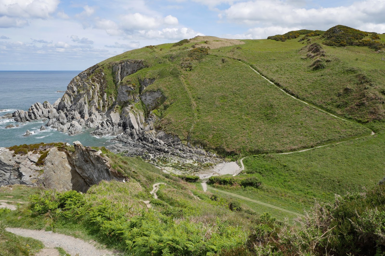
We continued clockwise in a wide arc some way away from the lake itself and came to a magnificent sunken lane which the trees were projecting out into. The striated rock underneath was also clearly visible.


This led to a lane and great views to some of the well-known local mountains. Jon did carefully trell me the name of the peak on the left, but I confess I have forgotten.


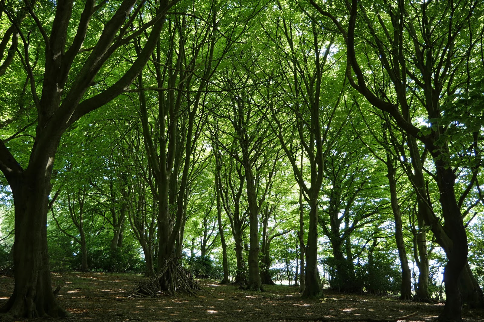
Soon we climbed into a splendid beech wood, Twyn y Cryn.


Emerging from this we headed towards Yew Tree Farm with its fine large wooden house.


Emerging from this, we passed the point where water from the River Usk enters the reservoir and entered an area of wonderful flower meadows. Scattered among them were two species of orchid, identified as ... Common Spotted ...


... and Southern Marsh.


These gave way to grassy track by the east edge of the lake, with nice views across to those mountains again.


There was however one more flower meadow and Jon encouraged me to try to get a pic of a single orchid in focus among all the other plants. It was a great idea and this was my best effort.


We paused for refreshments at the visitor centre and returned to the car park.


Conditions: a lovely sunny day.

Distance: 6.25 miles.

Map: Explorer 152 (Newport & Pontypool).

Rating: four stars. Lovely walk, interesting and varied.

Monday 22 May 2017

Ilfracombe to Combe Martin (South West Coast Path 98)

Ilfracombe from Beacon Point

We start this leg of the Coast Path at the back of the harbour in Ilfracombe. Ilfracombe is an interesting place and I have done a separate post about it. We walked along the landward side of the harbour. The tide was out, but the inner harbour was still attractive.


The outer harbour looked even more bereft.


We then headed up hill along a road and turned left into what felt like a park to emerge at this small cove. We wondered if we had gone the wrong way at first as we couldn't see a path upward (you can in fact just make out a handrail to the left of the concrete shelter. Fortunately a couple of chaps enjoying an early morning can of beer in a sort of belvedere to the left put us straight.


We climbed steeply up from the cove and continued a steady climb through trees and then more open ground over what the map shows as Fort Hillsborough. It seems to be named for an iron age chieftain called Hele. There were lovely views back over Ilfracombe and I used one of then to head my post about Ilfracombe. The best view however came from above Beacon Point (at the head of this post).

Now we descended through woodland along a winding path to finally emerge at Hele. The village was apparently once had a gas works (it closed in 1963) which was for many years supplied with coal by ships which moored at the wooden post which can be seen on the beach.  By the 1950s it had become a popular holiday destination (the coal now being delivered by road) and it was normal to have 200 deckchairs on the beach. And as the photo shows there is a rather tasteful collection of holiday chalets there now. the beach however is more like gravel than proper sand.


We climbed up the hill on a footpath beside the A399 road which continued just the other side of a crash barrier. We eventually took a left which led to the low-lying Rillage Point and then climbed. On the horizon the coast of South Wales stretched out before us.


I spotted a rather lovely Peacock and was quite pleased with this picture taken with the lens I normally use for landscapes and buildings, rather than the usual big zoom.


Soon we had a great view of the west side of Widmouth Head. No doubt we would soon be climbing the steep path on the left hand side.


And so it was. This is the view from the top of the path. In truth it wasn't too bad.


The view east from the highest point of Widmouth Point was wonderful. The narrow cove is called Water Mouth (a bit generic as name, I thought) and the peninsula to the left is The Warren. Hangman Point can be seen in the background. The Great Hangman at 318m is the highest sea cliff in England.


We enjoyed a nice break on Widmouth Point and saw a couple of Painted Ladies, neither of which would pause for a picture. I did get a nice one of a Stonechat however - we have seen lots of them is recent days.


We descended fro Widmouth Head to follow a path through woodland above Water Mouth and emerge opposite Watermouth Castle. This was begin in 1825 but not completed until many year later. It is now a family theme park, although this is not too evident from the road.


A little further on we left the road and walked uphill through a large, but mercifully empty, campsite. We then followed a high level path with at one point a wonderfully beautiful small cove down below. We later saw an access path.


Later the path was diverted so that we had to follow a road for a while as we meandered into Combe Martin. This was our first view. Around the corner is a sandy, but not all that attractive beach.


Conditions: Warm and sunny.
Distance: 5.3 miles.
Map: Explorer 139 (Bideford, Ilfracombe & Barnstaple).
Grading:  Moderate, Strenuous in places.
Rating: four stars.

Sunday 21 May 2017

Woolacombe to Ilfracombe (South West Coast Path 97)

Woolacombe Beach

The tide is out at Woolacombe and it's a bit cloudy, but plenty of people are having fun in the sea and on the enormous beach. We head along the grassy strip to the north of the beach and soon reach a remarkably sheltered little cove which goes by the strange name of Grunta Beach.


After this, the coast is quite rocky towards the next key landmark, Morte Point.


The path heads inland for a while and we climb a hill towards Mortehoe, walking along the road. After a steep climb we turn left to follow the path through a grassy headland towards Morte Point.


We round the rocky point and soon a new vista lays before us to Bull Point with its lighthouse.


This is a very attractive section and we make good progress, descending sharply towards Rockham Bay. We pass inland of Bull Point, which is less interesting up close than from a distance, and the coast stretches out ahead towards Ilfracombe.


We are briefly tempted to think that this will be a brisk cliff top walk when there is a sudden and dramatic descent/ascent at Damagehue Rock.


Soon after there is another at Pensport Rock.


 After this, the coast stretches out towards Lee.


Lee turns out to consist of a small cove with a not very attractive beach and a defunct hotel. However, there is an excellent café where we enjoy welcome refreshments and take a short restorative break from walking. 


 Leaving the café we follow a pleasant small road well inland from the sea which climbs steadily for a mile from sea level to 140m above sea. This is the view back. On the horizon is the coast of South Wales, around Milford Haven.


 This gives way to a couple of large fields covered with buttercups and cows. As we approach Ilfracombe, there is an excellent moment as we see our first Painted Lady of the year. Sadly, it didn't wait around long to be photographed. Soon afterwards, an entertaining, slightly grumpy, rusty sign catches our eye


Soon after this there is a moment of great excitement: the first Painted Lady of the year. It just won't wait long enough to be photographed. We pass between two grassy hills


And then we follow the twisting Torrs Path laid out the 19th century to emerge at the edge of the town and follow the road down to just behind the Landmark Theatre where we have a fine view of Capstone Point.


As we follow the path around the Point, there is a nice view of Ilfracombe with the Landmark Theatre on the right.


Once we have fully rounded it, we can see our next challenge, Hillsborough. The harbour, where we ended today's walk, can be glimpsed on the right.


Ilfracombe is an interesting place and I have done a separate post about it.

Conditions: Warm and sunny.

Distance: 7.8 miles.

Map: Explorer 139 (Bideford, Ilfracombe & Barnstaple).

Grading: Strenuous becoming Moderate.

Rating: four and a half stars.

Saturday 20 May 2017

Ilfracombe

Ilfracombe from Hillsborough

Ilfracombe has surprised us by apparently being the foodie capital of North Devon: we have noticed a number of good restaurants, including one with a Michelin star. The town perhaps isn't as good architecturally, but it is still very interesting and worth a walk around. It began as a fishing port and attempts to turn it into a seaside holiday resort began in the 1830s. Real success came only after a branch railway line from Barnstaple opened in 1874. There are many houses and hotels from the late Victorian period.

We started our walk at the dismal Imperial Hotel with the Landmark Theatre opposite. It was built to replace The Pavilion Theatre, a Victorian building partly destroyed in a fire during the 1980s and later demolished. I was surprised to learn this because I had guessed that the towers must be some sort of historical survival (kilns of some sort perhaps) which had been incorporated into a new theatre. The architects were Tim Ronalds Architects and the building won a RIBA regional award. Their website picture shows a much whiter building than currently greets the eye. Sadly, the website of North Devon Theatre Trust, a charity which runs it and a theatre in Barnstaple, announced in February this year that it had gone into administration.


Off to the left, in a wonderful position overlooking the sea, is this apartment block. I thought at first that with its three different styles of tower it must be some Victorian extravaganza, but on closer inspection I would guess that it is a modern building on the site of a Victorian hotel.


We headed off along Wilder Road in the direction of the harbour. There was a lovely terrace of two-storey houses with cast iron columns and ceramic tiles depicting the signs of the zodiac.


The last building in the terrace is about 1900 with nice art nouveau glass in the main window.


We passed the church St Philip & St James (1856) and winced at the signs calling it "Pip and Jim's". Trying too hard. Who on earth shortens Philip to Pip nowadays?

Now we detoured via Capstone Road to pass the former house of Henry Williamson, of Tarka the Otter fame. I confess to never having read the book, but as a large section of the Coast Path coincides with the Tarka Trail, we felt some affinity with Tarka and his author.


We then walked along the key noting the inner harbour with its surprising sandy beach. It is evidently used for sunbathing in the manner of Mousehole in Cornwall.


The outer harbour consists of just one jetty along the seaward side with the bulk of Hillsborough over to the right.


On the quay to the left is a rather extraordinary statue: Verity by Damian Hirst. The statue shows Verity pregnant holding a sword aloft and standing on a base of legal books. The figure's stance is taken from Little Dancer of Fourteen Years by Edgar Degas. The statue was installed in 2012 and has been loan to the town by Damien Hirst who lives in nearby Combe Martin.


On a hill above the harbour is the lighthouse. It is part of the small Chapel of St. Nicholas on top of lantern hill. The chapel was built in 1320 and a light has been shown from the building since 1650. It is said to be the oldest lighthouse in the country.


From the harbour we headed up Fore Street, an attractive winding street which seems to be the centre of the gourmet district.


At the top is the High St. It is still the main road through the town and so not pedestrianised. It is not an especially distinguished street, although I did like the former United Reformed Church of 1818 with its iron columns to the two side doorways.


Now down Northfield Road to pass the Masonic Temple (1899) ...


... and next door The Old Picture Hall, now apartments. I can't find out anything else about it unfortunately.


At the bottom is the neo-classical Tunnel Baths of 1836. Off to the right is the entrance to the tunnel which leads through the cliffs to a secluded bathing area. Sadly it has just closed so we never did find out what exactly was at the end.


This was the end of our walk. There is clearly lots more late Victorian architecture to see.

Conditions: bright and sunny.

Distance: a couple of miles.

Rating: four stars.