Monday 31 March 2014

Gaillac

Chateau de Foucaud

We have just arrived in Gaillac to visit our friends Dave and Chris and off we go on a short tour of the town. We start at the Parc de Foucard, where the 16th century chateau now houses the Musée des Beaux Arts.

At the rear there is a formal garden with this beautiful pavilion in one corner. It was intending for pursuits such as reading, symbolised by the sculptures on the roof.


From here we walk close to the river Tarn towards the remains of the old town walls and the former Abbey of St Michel. It dates from the 10th century, but was rebuilt in 1271 and again between 1572 and 1620 after being damaged in the wars if religion.


We then turned away from the river to pass by the east end of the abbey church and round to the wine tasting centre where we bought some Gaillac wine called Astrolabe. Extensive tasting later confirmed that it was excellent.


From here we went to the arcaded Place du Griffoul and enjoyed the brick and timber houses and the renaissance-style covered market.


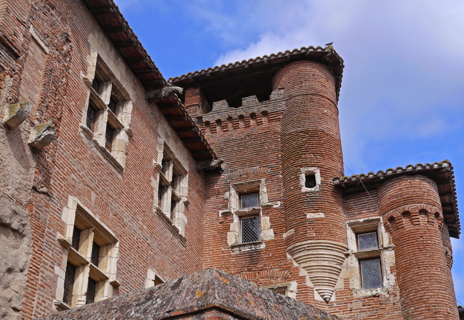
Just behind the Place lies the wonderful Hôtel de Pierre de Brens: the town house of the Pierre de Brens family from the 13th to the 16th century. It is a substantial brick-built windows with mullioned windows, projecting towers and brick corbels.


A few steps further and you are in the large Place de la Libération, a large, recently refurbished space, which turned out to have an excellent patisserie which I could not resist trying (a religieuse, in case you are wondering). This square leads in turn to the Place d'Hautpoul, dominated by the neo-classical Hôtel de Ville.


We headed back through the La Portanelle quarter, where we were very struck by this row of recently renovated houses.


And by these nearby with the first floor jettied out into the street.


Conditions: cloudy, mild, some sun.

Distance: a couple of miles.

Rating: four stars. A charming quiet town, off the beaten track. As restoration continues it will surely  become ever more attractive.

Saturday 29 March 2014

Mevagissey to Gorran Haven (South West Coast Path 47)

Mevagissey: The inner harbour

We are just doing a short stretch today as we have to be heading home. It will make the next key point, Portloe, easier to get to next time. We leave Mevagissey by, inevitably, climbing up from the harbour. The tide is out, but the inner harbour and the village are still picturesque.

The lighthouse on the outer harbour is especially lovely in the hazy morning. The tip of Black Head is visible in the background.


We follow the road round to Portmellon, with its shallow sandy beach and walk along a private road towards Chapel Point.


The coast path leaves the roads and descends to the the cliff edge and then across a grassy area towards Chapel Point. This picturesque group of houses look like they were built for a monastery or artists commune. Pevsner says that they were built by J A Campbell between 1934 and 1939. I have also discovered that the architect's own house is a listed building.


Adjoining Chapel Point is the peaceful Colona Beach.


Now, after a bit a climb, it was along the cliff tops towards Gorran Haven.


We reached the village and descended the narrow street to pass the picturesque St Just's church. Inside it consists only of a short nave with a ship's keel roof. Pevsner says it was largely rebuilt in 1885.


At the bottom you come to the lovely sandy beach with a breakwater to the right.


That's it for this trip. I pondered when we started out from Polperro on Wednesday whether we could still hack it after a six months layoff. I am pleased to report that we can. In fact we can't wait to continue.

Conditions: grey with a hint of rain, cool.

Grading: Easy.
Distance: 3.3 miles. Distance now covered 272.9 miles.
Map: Explorer 105 (Falmouth and Mevagissey).
Rating: three and half stars. A nice short walk with some interesting sights.

Friday 28 March 2014

Lower Porthpean to Mevagissey (South West Coast Path 46)

St Austell Bay

We set out from Lower Porthpean beach, which had struck us as a nice one for kids, and made the inevitable climb to the cliff top. We were very struck by how calm the sea was and by its pale turquoise colour. Out to sea, a couple of fishing boats were moored and around both of them hundreds of cormorants were floating in the sea. Sadly, they were too far out for  a photo

We walked along the cliff top and were surprised by a notice warning of a badger set ahead. It was a helpful warning however because there was a large hole in the middle of the path.

As we approached Black Head we were concerned to see another notice advising of a diversion because of a cliff fall. For the first time ever, this actually made the walk shorter as we were directed slightly inland from the Head itself. Once round the corner the next section of coast stretched out before us.
 

At Hallane, we admired this cottage part way up the winding valley.


A bit further in there was a fine view across St Austell Bay towards Mevagissey, with its furthest extremity, Chapel Point, clearly visible on the left. We were please to see the blackthorn blossom in the foreground.


Soon there was a classic coast path combination of a steep climb down steps to sea level, followed by an equally steep climb up steps back to the clifftop. We were rewarded with a great view of the coast stretching back to Black Head.


From a little further on, you could see across Black Head to Gribbin Head with its beacon surprisingly clear amidst the cloudy sky.


This was a particularly indented stretch of coastline.


But as we reached Pentewan things changed. First we passed an intriguing group of buildings: a chapel (with a cross enriched with light bulbs outside), a fine terrace of houses with a splendid veranda in front and then a handsome Georgian house with lovely windows.


We descended to sea level and walked through the village and along the road to skirt the large holiday village which is set back from the lovely sandy beach. This is the view looking back once we had regained the cliff top.


This cliff top section contained a further badger warning: this section of path was being "undermined" by badgers. It seemed a bit extreme, as if the poor old badgers were waging a military campaign.

Eventually we reached houses on the outskirts of Mevagissey and descended to enjoy this lovely view of the Outer Harbour in the evening sunshine, with Chapel Point in the background. The Inner Harbour was built only in 1774, with the outer one following in 1888. It had to be rebuilt in 1897.


Conditions: cloudy, but bright and quite warm

Grading: Strenuous. 
Distance: 6.5 miles. Distance now covered 269.6 miles.
Map: Explorer 105 (Falmouth & Mevagissey).
Rating: three and half stars. A pleasant but not very distinctive section. We saw quiet few typical seasonal wildflowers (celandine, stitchwort, red campion, violet, broom) and a few Small Tortoiseshell and Peacock butterflies.

Thursday 27 March 2014

Fowey to Lower Porthpean (South West Coast Path 45)

Fowey


Our first view of Fowey was from the main car park. On the right is the church of St Fimbarrus, which dates back to 1336. To its left is the strangely named Place. This is the seat of the Treffrey family. According to Pevsner, the house was originally built some time after 1457. Parts date from the 19th century. In the background the waterway on the right is the Pont Pill, while the River Fowey is on the left. 

This is the view across the river to Polruan where we finished our walk last night.


We followed the Esplanade out of town and soon reached a vantage point with a view of St Catherine's Castle. 


Fowey was a major point in medieval times and after a celebrated French attack in 1465, blockhouses were built on either side of the river with a chain suspended between them.  The castle was added by Henry VIII as part of his comprehensive strengthening of south coast defences. (We have seen lots of other examples e.g. at Dartmouth, Hurst Castle near Bournemouth and on Portland).

After passing the bizarrely named Readymoney (this may be a Cornish tradition: the equally odd London Apprentice is near St Austell), there was a good view of the river. The Polruan blockhouse can still be seen on the right.


We headed out along a grassy cliff to path and soon began to enjoy views of the major natural feature of this section of coast: Gribbin Head.


On many of the path sides, especially when the path was climbing there were numerous primroses. This was a particularly good couple of clumps.


At Poldridmouth we were surprised to see a large isolated house right on the path, with this inviting lake beside it. The swan was certainly very well set.


As we approached Gribbin Head, you could look back on yesterday's section to see the houses of Polruan with Pencarrow Head behind.


A steady climb took us to the top of Gribbin Head, where the red and white striped tower could finally be seen for what it was. We thought it was maybe a lighthouse that had lost its light, but it turns out that it was purpose built as a beacon in 1832 by Trinity House.


The path became increasingly muddy as we walked up the west side of the peninsular which ends with Gribbin Head and we were glad to finally make the steep descent into Polkerris. A village with a lovely little beach, a pub where we enjoyed a refreshing drink, and not much else. This is the view back as you climb up out of the village.


Quiet soon we reached the start of Par Sands. This is the view from the far end looking back: the view which immediately confronted us was less inviting, as the west end of this large sandy beach is dominated by the China Clay works.


We walked along the back of the beach and were then forced to head inland through a Holiday Park and along the main road to skirt the works. Eventually we rejoined the coast again to walk beside Carlyon golf course and then what seemed to be a former quarry. Another grassy stretch then brought is to Charlestown.

This is known principally for its port, established in the 18th century by Charles Rashleigh, the major local landowner - and the village, then called West Polmear, was later renamed in his honour. It was originally built to facilitate the transport of copper from nearby mines, but its main function became the export of china clay from the region's quarries.


There was a dramatic view back in the evening sunshine as we climbed up to the former gun battery.


Less than a mile later we arrived at Lower Porthpean, tired but feeling a good sense of accomplishment from a long walk.


Conditions: grey at first, becoming sunny.

Grading: Moderate.
Distance: 11 miles. Distance now covered 263.1 miles.
Map: Explorer 107 (St Austell and Liskeard).
Rating: four stars. The section around Par was a bit grim, but this was otherwise varied and interesting.

Wednesday 26 March 2014

Polperro to Polruan (South West Coast Path 44)


Polperro harbour

After a six month break we are back on the South West Coast Path. Can we still hack it?

We pick up the route at Polperro. As we walk the half mile down from the car park to the harbour it is already beginning to rain slightly. We climb up to the cliff and enjoy the view back to the town. It is too gloomy to be worth photographing, and anyway the tide is out. Above I have used a picture I took when we reached here last September.

We walk along Chapel Cliff and past various other natural features. The rain gets heavier. We think that this will not be much fun it continues for the whole walk.  However, after about an hour and a half of level stretches interspersed with classic descents and ascents, it finally stopped raining. I snatched this picture of the snaking path ahead, thinking it might be the sole image of the walk.


Out to sea we could hear what seemed to be a bell tolling and after a while we identified it as a buoy with a bell, presumably warning against the rocky coastline. On the rocks the agitated peeping of Oystercatchers could repeatedly be heard. As we drew level with Lansallos, this lovely view towards Pencarrow Head presented itself. There was still plenty of rain in the sky.


And as we reached sea level the rocky coast looked especially dramatic.


As we climbed up again, there was a nice view back of this little secluded cove, Palace Cove.


Pencarrow Head Proved to be further away than it looked, but eventually we were felt we were getting nearer. This was the view back towards the way we had come.


At length we turned Pencarrow Head and began to walk around Lantic Bay on a high level path. As the sun came out, we were struck by the sudden change in the colour of sea and sand. The delightful, unspoilt Great Lantic Beach is in the centre of this picture.


The view back from the other side of the bay was pretty good too.


We climbed Blackbottle Rock and began the approach to Polruan. As we got nearer to the Fowey estuary there was a fine view in the gathering gloom across to Gribbin Head, with the Gribbin Tower visible above it.


We walked down to the quay and looked across the river to Fowey (pronounced foy). And then had a nice glass of wine in the nearby pub while we waited for a taxi back to Polperro.


Conditions: very wet at first, then mainly sunny. We felt cold much of the time.

Grading: Strenuous.

Distance: 7.1 miles. Distance now covered 252.1 miles.

Map: Explorer 107 (St Austell and Liskeard).

Rating: four stars. A totally unspoilt section with some beautiful coastline.