Friday 27 October 2017

Canterbury


Canterbury Cathedral

A nice day was in prospect so I thought I would progress my English cities project with a visit to Canterbury. I have walked and blogged 33 out of 51 - see my Cities page. It would be all the more interesting because I was a graduate student there more than 40 years ago and I haven't been back since.

I was armed with a walk route from The Guardian that started at Canterbury East, but I arrived at I arrive at Canterbury West station since East did not have not such a good service), so I had to improvise! I started by going completely off piste and heading for Manwood's Hospital, almshouses in St Stephen's Green dating from 1570.


Actually this was rather fortuitous because it meant walking in the direction of the University and I did get a slightly nostalgic glimpse of some of the buildings on the hill outside the city. I headed back towards the city centre along the busy norther ring road and turned left to follow the quiet banks of the shallow and rather lovely Great Stour river.

Reaching St Radigund's St I turned left, away from the river towards the High St, passing the colourful Blackfriars St ...


.. and then later, in Guildhall St, this art deco Debenhams shop with colourful stained glass in the upper parts of the windows.


Once in the High St I turned right (west) to pass the wonderful Royal Museum and Art Gallery of 1857.


A little further along was the Eastbridge Hospital (the Hospital of St Thomas the Martyr, to give it its full name), founded in about 1176 as a hospice for poor pilgrims visiting the shrine of St Thomas a Becket. This is pretty quick work, since Becket was murdered only a few years earlier (29 December 1170). It became an almshouse in the 16th century and continues in this role to day. For a long period part of it was also used as a school.


Inside there is a wonderful undercroft where the pilgrims slept in cubicles, but when the hospital became an almshouse it was used as a coal cellar. It was restored in 1933.


There is a chapel on the ground floor which was closed in 1547 and restored in 1969, and on the first floor a refectory with a rather damaged mural of Christ in Glory.

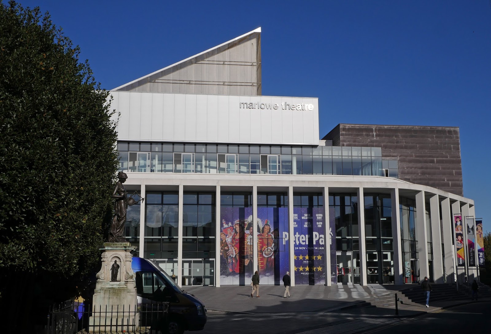
Continuing along the High St there was the Marlowe Theatre off to the right. It was designed by Keith Williams and opened in 2011. It is the third theatre of its name in Canterbury and is named for Christopher Marlowe who was born and attended school in the city.


By now I realised that I was going to do an  anti-clockwise circle, culminating with the Cathedral and then heading back to Canterbury West.The next port of call was the Westgate, which the one thing I had a very clear memory of. It was the built in 1379 and has the distinction of being the largest surviving city gate in England. I took my photo from the inside because here too the road outside was choked with traffic.


I headed back up the High St and turned right down Stour Street to pass the Canterbury Heritage Museum. The building was once the 13th century Poor Priests' Hospital, but it was turned to secular uses in 1579.


At the end I turned right into Gas St to emerge by the ruins of the Norman keep. It was largely constructed in the reign of Henry I as one of three Royal castles in Kent (along with Dover and Rochester). By the 19th century it had been acquired by a gas company and was used as a storage centre for gas for many years, during which time the top floor was destroyed. It is currently closed, having become unsafe.


I was no more or less opposite the East station and I walked a short way on the bridge over the ring road to get the excellent view of the walls promised in my walk description. It was indeed a fine sight.


The first city walls were built by the Romans and by the 12th century the walls were ill-maintained and of little military value. Fears of a French invasion during the Hundred Years War led to a great rebuilding programme. Parts were demolished in the 19th century and there was some bomb damage during the Second World War. Happily, there was further rebuilding in the 1950s and now over half the original circuit survives. There is a pleasing walls walk around Dane John Park.


After this section of walls I headed away from the city centre for a brief glimpse of the gatehouse of St Augustine's Abbey. The abbey was founded in 598 as a Benedictine monastery and functioned in this way until its dissolution in 1538. It was just dedicated to St. Augustine, it was actually founded by him. There wasn't time to go in so I made do with a quick snap of Abbot Findon's Great Gate. It was rebuilt after a long period of decline, which affected the whole abbey, and bomb damage during the Second World War.


Now I finally headed towards the Cathedral, entering through the magnificent Christ Church gate, built between 1504 and 1521. It is thiought to have been built in honour of Prince Arthur, Henry VIII's elder brother who married to Catherine of Aragon in 1501.  Arthur died the following year aged just 16: Henry VIII became King and married Catherine himself in 1509.


I had of course left it too late to do justice to this huge and wonderful cathedral. Founded in 597, the cathedral was completely rebuilt from 1070 to 1077. The east end was greatly enlarged at the beginning of the twelfth century, and largely rebuilt in the Gothic style following a fire in 1174. The Norman nave and transepts were demolished to make way for gothic replacements. I had forgotten just how big it is: 160m long and 50m wide; the crossing tower is 70m high. Quite overwhelming.

Two parts especially caught my eye: the cloister, rebuilt 1397-1444 is a beautiful space ...


... and the stained glass on a deep blue background in the Trinity chapel.


Having proven that there really is too much to see in a single day and that I could recognise almost nothing of the city, I decided to call it a day, promising to myself to come back before too long and finish the job.

Conditions: a lovely sunny day.

Distance: the walk which I didn't really follow was only 2.5 miles. My own meander must have been about 4.

Rating: five stars.

Tuesday 17 October 2017

Breamore

Breamore House

We were on our way to Poole for a short visit and decided to make a detour to see Breamore House, which had been recommended by a friend. We had a very enjoyable and informative guided tour, from which we quickly learned the correct pronunciation of the name: it is Bremmer Hice. It was completed in 1583 by the Dodington family. It was purchased in the 18th century by Sir Edward Hulse, who was a Baronet and Royal Physician. It is still in the Hulse family to this day. The house suffered a major fire in 1856.

The highlights of the tour were the great hall, the paintings and tapestries and several Tudor beds. Unfortunately, photography is not allowed so I have no pictures. We also learned that the estate was used by the Americans under General Patten during the Second World War, specifically for the preparation for the assault on Omaha beach.

Opposite the entrance is this fine tower. It was built as a water tower, although no longer used as such, in the 19th century. I suspect this was after the fire mentioned above. It is very charming.


After the tour we walked back down the drive to visit the Saxon church of St Mary's which lies just outside the grounds. The church was probably (according to the helpful information leaflet) founded by Ethelred II (The Unready) around 1000 AD and was originally a Minster church. Alterations were made in the 14th, 15th and 16th centuries and there was the inevitable restoration during the 19th century. This included removing external plaster to reveal the flint and stonework.


Inside, the archway to the South Porticus (on the right in the picture) contains a Saxon inscription from Ethelred's reign. It is translated as Here is manifested the word to thee.


At the chancel end there are the remains of wall paintings from the 13th and 15th centuries.


Conditions: grey, wet.

Rating: four stars. A delightful place, well worth a visit.

Monday 9 October 2017

Sevenoaks and Knole

The Red House

Another town walk with Merv. We parked in the centre of Sevenoaks and began our exploration by walking down the High St. The southern section is full of fine buildings. The first we noticed was  Then there was The Red House (above), an imposing building of 1686 – Pevsner describes it as the finest in the street. A plaque reveals that Jane Austren's uncle once lived here. It is now occupied by a firm of solicitors with a comedy name - Knocker & Foskett.  

The Chantry, right on the road, another fine house of the 17th century.


On the right is the attractive church of St Nicholas built of local ragstone and currently under refurbishment.


Still heading south we came to Sevenoaks School. It was founded in 1432 for poor children and rebuilt in 1724-31 in the Palladian style. The school was in a central building set back from the road ...


... while the two wings were almshouses facing directly onto the street. It looks as though they have now been incorporated into the school.


This is the southern edge of the town and we retraced our steps and turned right along the low-key entrance drive to Knowle House, which initially passes through more school buildings. Soon there is a winding road through the extensive parkland of Knowle.


We turned off the road and headed uphill to emerge on a plateau and be faced by the beautiful façade of Knowle.


It turns out that this façade was added in 1460-67 by the then owner Thomas Bourchier, the Archbishop of Canterbury. When you go through the entrance the original gatehouse and range becomes visible.


Over to the right is the Orangery which seems to have recently been restored and opened. It is a lovely space with an agreeable faded and slightly battered colour scheme.


Knowle was taken over by Henry VIII and later passed to Thomas Sackville, Earl of Dorset. He died in 1608 and Sackvilles and Sackville-Wests have lived there ever since. Their heyday was doubtless in the 1920s with Vita Sackville-West. Her brother, Eddy, lived in the gatehouse and the National Trust, who have owned the house since 1946, have recreated the rooms in the tower to reflect this period. This is the view from the tower.


The other great view from the Gate House was along the gables of the main facade with stone leopards as finials.


We then set out for a 4 mile circuit of the large park, guided by a map and description on the National Trust website. I have to say it wasn’t that easy to follow and we soon found ourselves improvising. Still it was a very pleasant walk.

Towards the end we crossed a long valley not unlike the one we saw at the start of the walk. 


We then entered a woodland and blundered around a bit,  spotting numerous deer and these strange twisted trees.
 

When we made it back to the plateau by the house we left the park by the entrance we had a arrived in and headed up the High Street. At the point where it splits and London Road goes off to the left there was a lovely old street light and road sign combination.


Returning to the High St we turned right for a pub lunch and a wander round the rest of the town. We enjoyed the tiny Market House of 1843, now a shop. It was apparently converted in 1896 for the YMCA when the terracotta details were added.


 There wasn’t much else of note, but we did like this house with its Dutch gable in a side street.


And in London Road we noticed the former Lady Boswell’s School of 1818 and the first work of the architect C R Cockerell. It is now a restaurant.


Conditions: A bit grey, but quite mild.

Distance: About 6 miles.

Rating: Four and half stars. An excellent day out.

Saturday 7 October 2017

Mahon (part 2)


 The entrance hall of Ca n'Oliver

It's our last day in Mahon and the goal is to explore some parts in more depth. We start with the Ca'n Oliver which houses the Hernandez Sanz - Hernandez Mora Collection. Entirely by coincidence Ca'n  Oliver is 100 m from our hotel in Cale Anuncivay. The exterior is featured briefly in my post Mahon (part 1). The house was built in the 18th century as manor house of the wealthy Oliver family. At some relatively recent point it was purchased by the government, refurbished and made into a museum covering aspects of Menorcan history and housing the art collection of Francesc Hernandez Sanz and his son Francesc Hernandez Mora. The entrance hall with its magnificent staircase is astonishing. Above is the first view from the hall and below is a view with more detail of the staircase


The ceiling at the top of the stairwell is beautifully painted as are the ceilings of almost all the rooms.

The historical information is informative and very well presented and there are some nice pictures and artifacts. The great surprise of the building is that there is a tower at the top which offers great views over Mahon. It can be seen from the courtyard at the rear of the building.


 It is not very well publicised and requires a steep climb up a metal staircase, which perhaps explains why we had it to ourselves. There were some great views. This one shows Santa Maria, the C'an Mir and the naval base.


 Now we headed across to the Museum of Menorca, which as luck would have it is located next to the third church, St Francis. Unfortunately, most of the museum is currently closed for renovations, but the exquisite late 17th century cloister remains open and is well worth a visit. The central space with its well is surrounded by massive columns with capitals in an unfamiliar style.


The arcades are even more wonderful.


We also had a closer look at the facade of St Francis and admired this angel sculpted on one side of the main portal. There was another nice sculpture on the other side.


From here we headed down to the port for a boat trip up the harbour. Mahon's harbour is 4.5km long and 1km at its widest. It was one of the most important in the world in the turbulent years of the 18th and 19th centuries. We set out more less opposite the naval storehouse on Illa Pinto, with its gun emplacements.


The next landmark, high on the hill to the left, is the handsome villa Sant Antoni. It was known by the British as the Golden Farm and was reputed to be the location of Lord Nelson and Emma Hamilton's trysts.


This was followed by the Illa dei Rei, once the site of a hospital. British sailors named it Bloody Island as it was alleged that surgical waste was tossed into the harbour.


Further along on the left hand side was this extravagant modern house in a prime spot on top of the hill.


Now we came to the Canal de Sant Jordi (St George).


At the other end there was  a fine view of the Fortress of La Mola, which we have seen from further afield on previous days.


As we approached the mouth of the harbour we passed the massive gun batteries which defended it.


Emerging from the harbour mouth the boat (which was glass-bottomed) moored for a while in a bay called Es Clot for us to see the fish. I have to admit that this was a bit disappointing, but soon we were underway again and passing the ruins of the original fort built to protect the harbour. This was followed by the Illa de Lazareto, the quarantine island. This one functioned between about 1815 and as late as 1918. Venice had one as early as 1423.


Finally as we neared the maritime station, we passed Es Castell and had a lovely view of the shoreline of the old town.


Conditions: bright and sunny.

Rating: four stars. It was very interesting to understand the relationship between the various islands and structures in the harbour. But it was even more pleasing to travel through a harbour that I had read about in  Patrick O'Brien's Jack Aubrey stories.