Showing posts with label Surrey. Show all posts

Thursday, 13 June 2019

Polesden Lacey

Polesden Lacey: The main facade

We met up with our friends Viv and Giles at Polesden Lacey intending to see the house and have a walk around the surrounding park. It was mostly raining however so the walk had to be abandoned. There has been a country house here since 1336, but it has several times times been rebuilt and the house you see today dates only from 1906.

You enter the estate through what once was a stable yard, now of course a plant shop and refreshment area, and follow a path down towards the house.


There is a lovely vista over the surrounding parkland.


As the rain had relented for a moment we decided to explore the gardens and headed round to the side of the house.


And then on beyond the rear elevation. The house seems to be a massive square, but there is an inner courtyard which is not apparent until you are inside.


Continuing along the path we come to a series of lovely walled gardens.
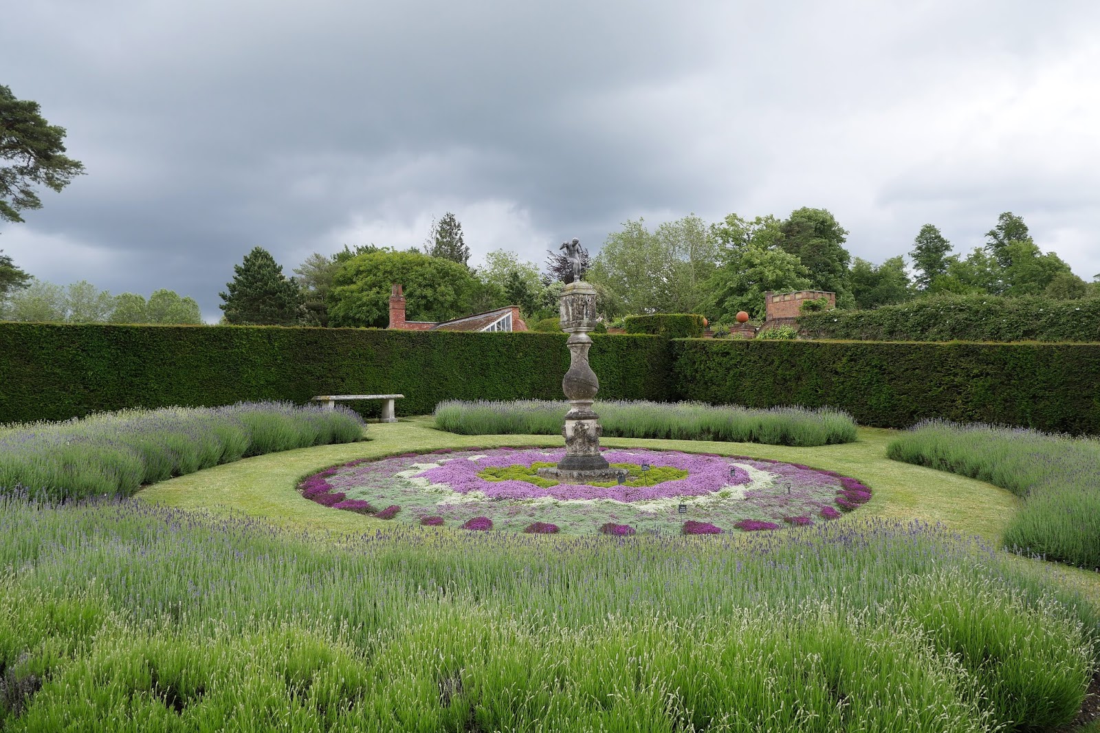

The second of these has some lovely roses.


The thirds walled area has beautiful roses and other flowers. We have read that Polesden LAcey os on the National Trust's most popular properties and we suppose that the gardens must be one of the maon attractions.


We were quite amused by this huge plant.


On the way back to the house - it is now raining again - we admire these classical statues placed against carefully cut hedges.


Entering the house you are first confronted by a large wood-paneled hall, which includes on the right the reredos from a Wren church. We soon learned that the house came into the possession of Ronald and Margaret Greville in 1906, having been bought for them by Margaret's father, William McEwan, founder of the famous brewing empire. (I remember drinking McEwan's beer as student before I saw the error of my ways and moved onto wine.)

Ronald died in 1908 and Margaret ran Polesden Lacey as a party house for the rich and famous until she gave it, in memory of her father, to the National Trust on her death in 1942. It seems that she was in fact the illegitimate daughter of her father and his housekeeper, but its doesn't seem to have held her back from being in with the rich, titled and famous.

To be honest the rooms, although spacious, are not especially exciting and one gilded one is totally over the top. The passageways around the central courtyard are rather attractive however with their Jacobean style plasterwork.


Conditions: grey and wet.

Rating: four stars. A very enjoyable day out. It would have been nice to have explored the park, but the weather did not allow it. I must say that the National Trust volunteers were especially friendly and informative.

Monday, 6 June 2016

Oaken Wood, near Chiddingfold


Wood White

My mission for today was to see a Wood White, a species I had previously only seen in France. Oaken Wood was the nearest location recommended in David Newland's excellent book Where to see butterflies in England, so off I went. As you can see from the photo above, I was in luck.

Oaken Wood is part of Chiddingfold Forest SSI and the discrete entrance can be found on Plaistow Lane, the road between Dunsfold and Plaistow. The entrance to the 20 acre Oaken Wood is off the main track through this forested area,


The initial narrow path soon opens up into a clearing with a central oak tree. This is identified on the information panel, rather fancifully, as Berkeley Square, although it was helpful to have names fro key areas.


I followed a track beyond the tree into deeper woodland, spotting a female Brimstone, and turned left when I reached the boundary of the wood. Following the path round to the left past a small pond, I emerged into a larger area of scattered trees and bushes,  The Meadow, and as I did a small white butterfly flew up beside the track to entertain me: it was my first English Wood White. Here is a view of The Meadow.


I wandered around this area and then followed a path back to Berkeley Sq, and now decided to walk over to an area called Botany Bay along the main path. This soon produced a pristine Speckled Wood ...

...  whaich also allowed a nice underwing shot.


Once I had left the edge of Oaken Wood I saw three more Wood Whites in quick succession and, chatting to someone doing a butterfly transect, I learned that an area further along the path was an especially good spot for them. And as I walked through that section of path, I saw another ten!


I also met a charming couple called Maggie and Steve who have been pursuing the obvious but challenging goal of seeing all 59 British species and have three left to go. I admired their determination, e.g. spending six days of a seven day mission to the west of Scotland in search of the Chequered Skipper sheltering from the rain, but seeing one on the seventh. It made me think I should put more effort into increasing my personal tally of a mere 42.

As well as Wood Whites there were a few Brimstones and several lovely Common Spotted Orchids, of which this was the biggest.


A smaller one nearby was host to a large white Crab Spider.


On reaching the road at Botany Bay there was nothing for it but to turn round and head back to the opposite edge of the wood, adding a few more Wood Whites to give a total for the day of 16.

Conditions: sunny, sometimes cloudy, and hot.

Distance: about 4 miles.

Map: Explorer 133 (Haslemere and Petersfield).

Rating: four stars.

Tuesday, 5 May 2015

Marley Common to Clayton Court (Serpent Trail 3)

Ridge Plantation

We have decided to try to speed up our Serpent Way project with Viv and Giles and have planned a bit over 8 miles today with a picnic in the middle.

We left the car park on Marley Common and rejoined the trail, having carefully noted how to do so at the end of the last leg. I have to admit that before very long we missed a turning on the left and realising we had lost our route backtracked until we found it.

The Serpent Way waymark is a rather pleasing white isosceles triangle with a maroon serpent motif. The triangle is placed on a post with the apex pointing in the desired direction. Mostly this works splendidly, but it does take a bit of study to identify which of the three sides is the apex - perhaps it could be marked with a maroon tip? But also the markers are quiet small and if you are deep in an interesting conversation it seems to be terribly easy to miss one.

We eventually negotiated our way off Marley Common and into the Ridge Plantation. Forest tracks  led us into Linchmere Common and then to Stanley Common where we found some wonderful felled trees which made an excellent picnic spot.


We must have wandered off piste after this because we reached a road where there was no sign to help us. However, skilful map reading enabled us to work out that we had to turn right and soon we were back on track - a long straight one through more woodland and then a golf course.

This brought us to the Liphook to Petersfield Road (B2070) and a pub. Giles and I especially were dismayed to find it was closed. After this we followed a track into more woods and - again! - missed a turn. Again, some good map reading enabled us to work out where we had gone wrong and find a corrective course which would reconnect with the official path at the edge of Chapel Common.

A wide track brought us down to the B2070 again and we followed it into Rake where we did find an open pub and a refreshing drink. From Rake a path led down through Rake Hanger. On the left there were some artificial fish ponds.


The hanger was a really delightful piece of woodland.


At the edge of the wood, the path meets a small road and turns back on itself, in keeping with its name. We continued on a short distance to the car park on the edge of Durford Wood where we had parked the car. Just beside it was Clayton Court, which a glimpse through the fence convinced me might be a fine country house. Perhaps it was once, but it is now apparently a care home.


Conditions: greyish but mild.

Distance: 8.4 miles. Distance now covered 15.7 miles.

Map: Explorer 133 (Haslemere and Petersfield).

Rating: three stars. We had a really enjoyable walk, but in truth it was more about the company than the inherent features of the walk itself. The main issue for me is that there are no views: alternating common and woodland is pleasant enough, but it does tend to merge into a sort of green nothingness. Not a single butterfly either, although that of course is more about the weather.

Friday, 17 April 2015

Black Down to Marley Common (Serpent Trail 2)

Black Down

We started the Serpent Trail with Viv and Giles last December, but it has taken a while to return to it. We resumed at the car park near Balck Down and walked through woodland to emerge onto open heathland.

To the right there were nice views to the east.'


We last walked in this area in July 2014, starting out from Fernhurst. On that occasion we failed to locate the evocative-sounding Temple of the Winds. We were hampered by our belief that it was something resembling a temple, we had the idea that there was maybe a circle of stones or something similar.

As we were heading along the path we met another group of walkers who enquired if we knew where the Temple of teh Winds was - they had seen signposts, but couldn't find it. We made sympathetic noises. This time we did locate the Temple, not without some difficulty - even when close up it was somehow hidden. It turns out to be a belvedere just below the edge of the hillside with a wonderful view to the south.


This is at the southernmost point of Black Down and we headed away to the north to soon overtake the other walkers who had stopped for a break. They were very gracious when they received the news that we had located the elusive Temple.

Further on we started to see the distinctive cattle, Belted Galloways, that the National Trust uses to graze the heathland. They are certainly well-named.


We continued along a broad path across the heath and then headed along the base of a grassy hillside, with a ridge ahead of us revealing scattered substantial houses.

Somewhere around here we missed our way and found ourselves walking along a lane with confusing signs to Valewood Farm House and Valewood House. We couldn't quite work out where we had gone wrong - or indeed where we were. After some trial and error behaviour we eventually worked out that we had been going in the right direction but were on the wrong side of a small stream.

Somewhat chastened,  made our way to the A286, Bell Road, and crossed it to walk through the woods of Marley Common to reach where we had parked.

Conditions: bright and mild.

Distance: 4.8 miles. Distance now covered 7.3 miles. We hope to increase our pace next time.

Map: Explorer 133 (Haslemere and Petersfield).

Rating: four stars.

Wednesday, 3 December 2014

Haslemere to Black Down (Serpent Trail 1)

Haslemere High Street

We met up with our friends Viv and Giles to start what we hope will be a new Long Distance Path project: the Serpent Trail. I noticed it marked on the OS map as I was searching for a walk in this area. The official website explains that it a 64 mile trail from Haslemere to Petersfield, designed to highlight the outstanding landscape of the greensand hills. The name comes from the twists and turns of its route. We "hope" because we are all a bit crocked at the moment, so progress may be slow. Still, a journey of a thousand miles and all that.

We start in Haslemere's attractive High Street: it just lacks an imposing building to provide a focus. We walk to the bottom and turn left into Petworth Road and soon take a path on the left: we were staggered to not find a way marker at this critical point.

The path soon passes an interesting structure. It is called Speckled Wood, after the butterfly, and was built by the National Trust in conjunction with the well-known woodsman and conservationist Ben Law.  It houses a training school for National Trust volunteers.


A curving path through muddy fields brought us back to the road which we crossed at Almshouse Common near the set of former almshouses which gave its name to the locality. They date originally from 1676 and have rather handsome porches. It seems that a further pair are being built on the exact same design.


We followed a climbing path, with a valley to our right and a high ridge beyond it to pass a couple of farms and reach a lane. Here we turned right, with distant glimpse of Leith Hill, the scene of a walk we did in 2009.

This soon entered woodland and twisted and turned to bring to where we had parked on the north east edge of Black Down.

Conditions: pleasant, if a bit grey.

Distance: 2.5 miles.

Map: Explorer 133 (Haslemere and Petersfield). Should be the only map we will need!

Rating: three stars. A very pleasant walk. It was very enjoyable to be out in the fresh air, but I couldn't find much in the way of photographic opportunities. Perhaps we were too busy talking!

Wednesday, 26 February 2014

Farnham

Farnham Castle: the remain of the keep

Another of our regular walks with Viv & Giles. I have driven through Farnham many times, but never had a close look and I planned this walk by combining a walk on the AA website with the town's Heritage Trail available from the Farnham Town Council website.

We started at the Farnham Park car park and were quickly greeted by a view of the Castle keep. The castle was founded by Henri de Blois in 1138. Henri was a younger brother of King Stephen and was Bishop of Winchester from 1129 until his death. The Castle was held by Parliamentary troops in the Civil War and like Corfe Castle was deliberately put beyond military use after the war.

The Castle remained an official residence of the Bishops of Winchester until 1927 and Farnham Park was originally the smaller of two deer parks which were enclosed around 1376. We started our circuit by following a beautiful avenue of beech trees.


At the far side we turned left and followed the perimeter, turning left again at the Upper Hale entrance to cross the park and emerge below the Castle. We were surprised by how large and how rural-seeming the park was.

We were soon in Castle St, where we turned left towards the town centre to immediately pass the Andrew Windsor Almshouses of 1619. They were initially founded for "eight poor, honest, old and impotent persons", as we were informed by two of the Trustees. There was some suggestion that as an enthusiast for almshouses, I should maybe aspire to live there, but it was agreed that I couldn't meet all the criteria. Pevsner is quite disparaging about these almshouses, finding them homely in comparison with the Georgian splendour down the hill. Perhaps inevitably, I find them rather charming.


We walked down the hill past some fine Georgian buildings, noting that one or two housed shops which were now vacant: we thought it would make sense to return this part of the town to residential use.

Then we turned right and left to find ourselves in the Lion and Lamb centre.


Most of this is a recent invention, but it has some charm, and the houses on the left here look quite old. We now turned right into West St and especially admired a series of Georgian buildings on the right.


After a brief look at the Museum, an unsuccessful foray along a side turning at least produced a wonderful spring sight: this lovely blossom.


We returned to West St and followed Church Passage to reach St Andrew's Church. It is a late 14th and 15th century church "violently" restored by Benjamin Ferrey in 1855. Pevsner, whose judgement this is, thinks that the best part is the tower and I wholly agree. It was just a bit frustrating that I could not fit it all into my photo.


We crossed the River Wey, previously seen at Pyrford and Tilford, but here here quite small and insignificant.


After an most enjoyable lunch at Loch Fyne, we followed Union Road and South St to turn into The Borough. At the junction with Castle Hill is the Town Hall with the familiar, but slightly surprising, market-like stalls outside. The Town Hall actually dates only from 1934 and was built in a neo-Georgian style to replace a "brash" (Pevsner) Victorian one.


The building to its right is the interesting Bailiffs Hall, originally of 1674, but rebuilt after the Town Hall was completed. Only the side remains of the original building.


We climbed the hill to reach the castle again and were delighted to be able to explore the grounds, seeing Bishop Waynefleet's Tower of 1470. Waynflete pioneered the use of red brick, also used in the construction of Hampton Court Palace and many Oxford and Cambridge Colleges. The windows are 18th century and this led us to think the tower must be much later. It is a very impressive structure. The Castle's website says that the two sundials refer to the passing hours with Latin mottos:
• “Practereunt” (“They pass by”) [to my eyes it says "proetereunt]
• “Imputantur” (“They are reckoned unto us”)


We then had a brief look at the keep and enjoyed the view over the inner courtyard with St Andrew's church tower and the Surrey countryside beyond.


Conditions: sunny and quite warm.

Distance: about 4.5 miles.

Rating: four stars. Full of interest. The castle and the almshouses were the highlights for me.

Wednesday, 4 December 2013

Guildford

The Royal Grammar School, Guildford

We met up with our friends Viv and Giles for this walk around Guildford. Giles attended the Royal Grammar School some years ago and so the walk featured a tour of parts of it. An extension of the walk to St Martha's Church had to be postponed until next time because of our late arrival and the indifferent weather.

We started the walk at St Nicolas church just across the bridge over the river Wey. There has been a church here since the 14th century, but the current incarnation dates from 1877 and is the work of S S Toulon. Pevsner thinks it is "ugly, but good and urban", whatever that means.


Inside, the west end has an extravagant font with a marvellous canopy ("ugly, but genuine, like the church" says Pevsner.) The wall behind is covered by a wonderful mural painted in 1893 by Joseph Pippet. Pevsner doesn't even mention it and one can suppose he must have been having bad day when he visited.


Just beyond the church in Bury Street are Caleb Lovejoy's almshouses of 1838. A two storey central building is flanked by two single storey ones, all with elaborate barge boards. The chimneys of the central building have very elaborate brickwork.


We crossed the river and walked up the High St, turning right to visit St Mary's church, whose tower is from the 11th century, predating the Norman conquest. Most of the rest dates from about 1180 and is transitional in style between Norman and Gothic. We could only go in as far as the Christmas card shop unfortunately.


From here it is not far to the ruins of the Norman castle, a huge 12th century keep.


We now headed towards the High St, reaching it opposite the Guildhall. It dates from the 14th century and was extended in 1589 and re-fronted in 1683, when the wonderful projecting clock was added.


Further up the High St is the remarkable Abbot's Hospital, an almshouse founded by George Abbot, the Archbishop of Canterbury, in 1619-22. The massive gatehouse is reminiscent of earlier buildings such as Hampton Court Palace or St John's College Cambridge.


The gatehouse leads to a small quad - you could be in almost any Oxbridge College.


A little further up the hill is a statue of the great man, a local boy made good.


Soon after that we reach the Royal Grammar School, founded in 1509 and given a charter by Edward IV in 1553. On our tour we saw the actual charter in the headmaster's office which also contains a rare library of chained books (we saw one of the other three such libraries in Wimborne Minster a couple of years ago). As you enter from the High St, you go through into a small quad - a curious echo of Abbot's hospital.


It was now becoming dusk and my companions felt a need for tea. I decided to carry on exploring and headed along nearby Chertsey St and into Stoke St to locate another set of almshouses I had read about, the Parsons' Hospital of 1796. It was by now quite dark and I have my camera's excellent ability to cope with low light to thank for this picture. The plaque under the central gable explains that it was given by the brothers William and Henry Parson.


Conditions: grey and cloudy at first, but becoming brighter.

Distance: three miles, including my detour at the end.

Rating: four star. Some really lovely buildings - and great fun too.