Sunday 14 December 2014

Woolland and Ibberton

The Vale of Blackmore

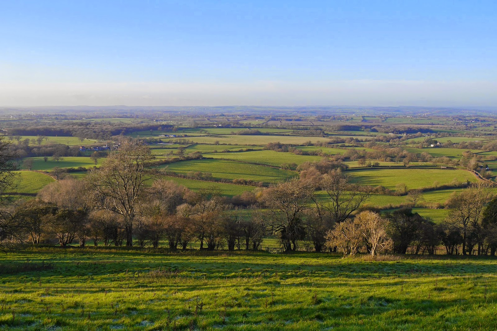
We had planned to go for a walk today and were delighted to wake up to a beautiful sunny day. We started the walk from the car park at Woolland Hill (an alternative to the car park above Ibberton) and marveled at the vast expanse of the Vale of Blackmore stretching out before us. You are around 900 ft above sea level (274m) and on a clear day you can see the Quantocks, the Mendips, Glastonbury Tor and Shaftesbury. Sadly, today was rather hazy at first and the picture above was taken towards the end of the walk.

We followed the road around the line of the ridge to reach Bulbarrow Hill with a great view to the south west along the route of the Wessex Ridgeway. Right into the sun unfortunately.

Now we back-racked a few yards and took a bridleway descending a quite steep hillside. This led into a field and a road and brought us to Woolland, with its pretty little church built by the prolific Sir George Gilbert Scott in 1857 in his favoured 13th century style.


Inside, the chancel with its apse featuring elaborate shafts, ribs and capitals along with delicately coloured stained glass was especially lovely.


From here we headed off across fields, extremely muddy and wet in places, towards Ibberton. There was a nice view of Ibberton Hill ahead, with the ground still frosty at 1pm ...


... and of this nice oak tree with the Wessex Ridgeway behind on the ridge above. We marveled at the black cow on the left with a solid band of white.


At Ibberton we had an excellent lunch in the Crown Inn. It looks quite run down from the outside with its faded sign board almost illegible, but inside there was a warm welcome and a tempting menu.

After lunch we climbed up the hill to visit the church of St Eustace (apparently one of only three with this dedication). Externally, it was rather a hotch potch of styles after being restored from a ruin in 1907-9 ...


... but inside we loved the fragments of Elizabethan stained glass. This piece depicts a Wyvern - usually described as being like a dragon but with two legs.


Observant readers will notice that this one has four legs, so perhaps his upright posture is the defining factor. I'll leave it there, but if you search on "how is a wyvern different from a dragon" you get lengthy discussions of the putative differences, or lack of them.
We now climbed steadily across grassy hillside to reach the road which runs along the Ridgeway and walked along for the best part of a mile to reach the car.

Conditions: blue sky, sunshine, just above freezing.

Distance: 4.25 miles.

From: 50 walks in Dorset (AA).

Map: Explorer 117 (Cerne Abbas and Bere Regis).

Rating: four stars. We were delighted with the sections along the Wessex Ridgeway and we have resolved to start walking it (perhaps just the Dorset section) next year.

Tuesday 9 December 2014

Paris: Art nouveau and Modernist architecture

View from the Palais de Chaillot towards the Eiffel Tower

I had planned an art deco walk for today to complement the art nouveau one we did last March. My research led me to a modernism walk produced by Time Out and I decided to use it as a point of departure.

As with the art nouveau walk we started in the 16th arrondissement, this time at metro Jasmin, and walked down Avenue Mozart to revisit, at number 22, the house built for himself by the great art nouveau architect Hector Guimard.


We then retraced our steps to go up rue Henri Heine and tune left into rue du Docteur Blanche to find down an alley on the left the Fondation Le Corbusier. This occupies a pair of villas designed by him and Pierre Jeanneret in 1923. The contrast with the curves of Guimard's house could hardly be more stark.


You have to knock to gain entrance and we had the place almost to ourselves. Inside the most striking thing is the way spaces flow into each other. It is also more colourful than one might expect.


We doubled back along rue du Docteur Blanche to find rue Mallet-Stevens on the right. This is a small cul-de-sac with six houses designed by Robert Mallet-Stevens - it seems unusual to name the street after the architect.  However, "Along with Le Corbusier he is widely regarded as the most influential figure in French architecture in the period between the two World Wars" (Wikipedia - so perhaps not quite so surprising).  Although the houses are mostly tall, the overall feeling is quite intimate.


We headed down rue de L'Assomption to rejoin rue Mozart and head towards Passy where we enjoyed an excellent lunch at the art deco La Roronda de la Muette restaurant. We then found our way to rue Raynouard where numbers 51-55 are celebrated works by Auguste Perret. They were built from reinforced concrete tinted to look like stone. Celebrated maybe, but also hard to like.


Across Place de Costa Rica and into rue Benjamin-Franklin where another block had more classic and pleasing art deco details and strong vertical emphasis.

We then reached the back of the extraordinary Palais de Chaillot, here seen from the bottom of the Trocadero gardens by the river Seine.


It is classical revival architecture on a massive scale and was designed by Leon Azema, Louis-Hippolyte Boileau and Jacques Carlu for the Exposition Universelle of 1937. In the plaza between the two wings there are some rather lovely gold statutes, four of which can be seen in the picture at the head of this post. The terrace overlooking the Trocadero is perhaps the best place in Paris to see and photograph the Eiffel Tower.

Just along Avenue President Wilson is the smaller, but equally eye-popping Palais de Tokyo, also built for the 1937 Exposition. Until 2002 it seems to have been something of a white elephant, but is now a successful location for art exhibitions.


At the of Avenue President Wilson, we crossed Place de L'Alma to find Perret's Theatre des Champs Elysses in Avenue Montaigne. It opened in 1913 and is again constructed in reinforced concrete, although this reflected the quality of the subsoil and the proximity to the Seine, rather than solely Perret's apparent preference for this material.


It is plain and quite austere, with the facade brighted by areas of gold paint and the lovely bas reliefs  by Antoine Bourdelles. Inside, art deco stylistic features are more to the fore (it proved to be possible to just wander in and have a look at the lobby).


Conditions: quite bright, but cool (6 degrees).

Distance: about 3.5 miles.

Rating: four stars. Very interesting and illuminating, but not much to love.

Postscript

I had hoped to conclude this walk with a trip to see the incredible Louxor Cinema (170 Boulevard de Magenta, right by Barbes-Rochechouart metro station), but we did not have time. So we went there first thing the next morning and what a fantastic building it is.


It dates from 1921 and is still going as a palace of cinema. This is the area under the main awning.


And this is a detail of the mosaic on the columns of the foyer.

Monday 8 December 2014

La Fondation Louis Vuitton by Frank Gehry

The Fondation Louis Vuitton

We had read about the newly opened Fondation Luis Vuitton and seeing it seemed to provide the ideal excuse for a short trip to Paris; we could also visit our friends Derek and Arlette who have just gone to live there. Derek joined us to see the Fondation.

Gehry is a veteran architect, probably best known for the Guggenheim Museum in Bilbao. He is usually described as "Canadian-American" which seems to simply mean that he was born in Canada, as Frank Goldberg, but has lived for all his adult life in America. He is also not afraid of controversy, asked whether "'emblematic buildings' [presumably including his] would continue to be a feature of modern cities", he replied according to the Guardian, “In this world we are living in, 98% of everything that is built and designed today is pure shit. There’s no sense of design, no respect for humanity or for anything else. They are damn buildings and that’s it."

The Fondation was commissioned by Bernard Arnault, head of the LVMH luxury brand empire and the richest man in France, as a gallery for his collection of modern and contemporary art. It is located on the edge of the Jardin d'Acclimatation, a sort of zoo-cum-amusement park right next to the Bois de Boulogne.

We approached the Fondation through the Jardin d'Acclimatation and first saw it end-on. It was much larger than we expected and very dramatic. It seemed at first to suggest a giant ship which was somehow opening its bows to us. 


We headed round to the right to try to get a side on view and were distracted by this rather lovely tower. It turned out to be a dovecote built during the Franco-Prussian war as a base for carrier pigeons used to send messages. We never worked out whether it was built there or moved there at some later point.

This did lead us to a good vantage point to see the Fondation - the picture at the top of this post. We could now see that there were a number of large panels which somehow cloaked the building. It was hard to determine its overall shape, but we did see people moving about in the gaps between the panels - I have since see them described as "sails", which seems apt - and this was very intriguing. Derek offered the view that it was "bonkers". We viewed this as quite a positive assessment and were generally in agreement.

We headed inside and we delighted to find an exhibition of a hundred or so models used as part of the design process. It was a bit overwhelming and too hard to literally trace the design history, but it was fascinating to see how these architectural models were made - bits of wood, cotton wool and paper in some cases. This was the final proof of concept model that ended the pure design stage.


We hurried up to the top level to see what was up there and were simply thrilled to see that were a whole series of terraces linked by steps and walkways. Some parts were covered, some exposed. We also began to understand the elaborate engineering behind the sails.


The gaps in the sails were delightful: for example this view towards the office towers of La Defense off to the west.


When we had finally exhausted the considerable charms of the roof terraces, we headed down to basement, walked through a large gallery to find an interesting water cascade leading down to a small pool.


Just round the side was this curious walkway with yellow lights.


It was only when we walked right up to the wall that we realised the quite extraordinary effect that had been created.


So, it was eventually clear that what you have is a light, airy four storey building which houses a series of large spaces to display art works. This is cloaked and made mysterious and striking by the sails and other effects. It is a remarkable building and a great place to visit. My only real criticism is that it lacks a decisive silhouette.

Conditions: grey and cloudy.

Distance: maybe a mile and half.

Rating: five stars.

Wednesday 3 December 2014

Haslemere to Black Down (Serpent Trail 1)

Haslemere High Street

We met up with our friends Viv and Giles to start what we hope will be a new Long Distance Path project: the Serpent Trail. I noticed it marked on the OS map as I was searching for a walk in this area. The official website explains that it a 64 mile trail from Haslemere to Petersfield, designed to highlight the outstanding landscape of the greensand hills. The name comes from the twists and turns of its route. We "hope" because we are all a bit crocked at the moment, so progress may be slow. Still, a journey of a thousand miles and all that.

We start in Haslemere's attractive High Street: it just lacks an imposing building to provide a focus. We walk to the bottom and turn left into Petworth Road and soon take a path on the left: we were staggered to not find a way marker at this critical point.

The path soon passes an interesting structure. It is called Speckled Wood, after the butterfly, and was built by the National Trust in conjunction with the well-known woodsman and conservationist Ben Law.  It houses a training school for National Trust volunteers.


A curving path through muddy fields brought us back to the road which we crossed at Almshouse Common near the set of former almshouses which gave its name to the locality. They date originally from 1676 and have rather handsome porches. It seems that a further pair are being built on the exact same design.


We followed a climbing path, with a valley to our right and a high ridge beyond it to pass a couple of farms and reach a lane. Here we turned right, with distant glimpse of Leith Hill, the scene of a walk we did in 2009.

This soon entered woodland and twisted and turned to bring to where we had parked on the north east edge of Black Down.

Conditions: pleasant, if a bit grey.

Distance: 2.5 miles.

Map: Explorer 133 (Haslemere and Petersfield). Should be the only map we will need!

Rating: three stars. A very pleasant walk. It was very enjoyable to be out in the fresh air, but I couldn't find much in the way of photographic opportunities. Perhaps we were too busy talking!

Friday 28 November 2014

Berkhamsted

The former Town Hall

I met up with my friend Chris for another of our ongoing series of walks in the Chilterns. This one starts at the station and I was staggered to discover when researching it right by the station are the ruins of Berkhamsted Castle. It was founded in Norman times and was of the well-known motte-and-bailey type. Hands up those who know which was the motte and which was the bailey! Happily Wikipedia has the answer: "A motte-and-bailey castle is a fortification with a wooden or stone keep situated on a raised earthwork called a motte, accompanied by an enclosed courtyard, or bailey."At Berkhamsted the motte is still plainly visible at one end of the site as are the straggling remains of the stone wall which surrounded the bailey.


We were most surprised by how large the castle was. The bailey was normally surrounded by a defensive ditch (not usually a moat) and Berkhamsted is unusual in having two ditches, which can still be clearly seen.

We headed round the perimeter of the castle and up a hillside and then along a ridge. There were nice views back down to the town and across to a ridge on the other side but it was too hazy to be worth a photo.

We descended back to the road and climbed a bit more to reach a war memorial. This commemorates the work of the Inns of Court Officers Training Corps which trained more than 12,000 officers during the First World War. It took me a moment to realise that this did not imply that all the offers came from the Inns of Court. We saw a sign nearby to the trenches which were used for this work.


We now walked a cross a golf  course to reach the hamlet of Frithsden, where we manfully resisted the temptations of the attractive pub and of the winery, which was open for tastings. We did stop however to admire the wonderful Little Manor whose upper storeys are covered in pargeting, decorative plasterwork. We saw a wonderful example in Ipswich called the Ancient House.


The house is believed to date from 1513 and a plaque on the right of the facade records a restoration in 1879 by Lady Marion Alford and her son Earl Brownlow.  The coat of arms is that of the Brownlow family.

We followed a field-edge path towards Nettleden and as we descended admired the gently curving valley ahead with a handsome beech tree proudly standing in the middle. I included the pink horse box in my picture for a splash of colour.


We followed the winding valley path past the tree and were making good progress until it suddenly disappeared.


The section was very hard work, but eventually we arrived at the outskirts of Ashridge, where we turned sharply left and climbed a grassy area crossed Berkhamsted Common and eventually entered Frithsden Beeches, a very pleasant area of woodland. We emerged into open country and walked back to the station.

I wanted to have a quick look at the town and crossed the bridge over the Grand Union Canal ...


... to reach the attractive High Street, with a nice miscellany of building from the 16th century onwards. To the left there was the Old Town Hall and Market Place (see photo at the head of this post). It is a rather picturesque building of 1859 by E B Lamb. In the other direction along the High St are the John Sayer Almshouses of 1684. Sayer was the Chief Cook to King Charles II. This sounds fairly modest, but he was able to leave £1000 in his will to pay for the almshouses.


Conditions: grey, drab.

Distance: 7.75 miles.

Map: Explorer 181 (Chiltern Hills North).

From: Walking in the Chilterns (Cicerone)

Rating: four stars.

Saturday 22 November 2014

Nantwich

St Mary's church

Our trip to Cheshire for a dinner-dance last night provided an opportunity to do a bit of exploring and I decided to see Nantwich, described by Pevsner (in 1971) as "a friendly country town". He explains that the town was notable for salt production from Roman times to the 19th century, along with Middlewich and Northwich, which carried on the tradition for longer.

I had planned to combine a walk around the centre with the Nantwich Riverside Loop Walk along the River Weaver and the Shropshire Union Canal, but in the event I did not have sufficient time. I parked in the centre and walked out along Beam Street in search of some almshouses.

I soon found Crewe's Almshouses. The sign over the main doorway says that they were erected by John Crewe in memory of Sir John Crewe and Sir Thomas Crewe.


Beyond them and to the right are Wright's Almshouses of 1638, built by a Lord Mayor of London, Sir Edmund Wright. They are fairly plain and I agree with Pevsner's comment that the best thing about them is the entrance with two big volutes and Tuscan columns. They were originally in London Road and were moved here in 1975 according to a detailed description in Wikipedia.


I retraced my steps and walked down Market St towards St Mary's church (see photo at the head of this post). It is basically 14th century, but was restored by the prolific Sir George Gilbert Scott in 1854-61 (we saw his work yesterday in Lichfield).

Standing outside the chancel and looking back towards Market Street, you see the severely functional Market building of 1867. At least the main facade gets some architectural treatment.


On the opposite corner is the Olde Wych Theatre of 1919 with rather bizarre, but amusing, crenelated corner tower.


Going round the side of teh church leads to the Town Squate with some noce Victorian Gothic banks and on into the High St where you are immediately confronted with these fine timber framed houses. They were built in 1584, immediately after most of the town was destroyed by fire.


I had a brief look at the adjoining streets, Pillory Street and Hospital St, both pleasant and characterful and then went to the top of the High St passing the impressive Crown Hotel, also of 1584, with a style of timbering I have not seen before.


The final stage of the walk was along Welsh Row, the "best street in Nantwich" according to Pevsner. I passed the half-timbered C17 Widows almshouse, now a pub and the similar Wilbraham's almshouses, derelict when Pevsner wrote and now single private house. 

Further up is this lovely Victorian house with a wonderful doorway-cum-tower.


And right at the top, a final set of almshouses, Tollemache's of 1830, strangely not mentioned by Pevsner. Two attractive blocks each of four houses, with gables, dormers and finials.


It remained only to return to the car and go off out to lunch.

Conditions: grey, but not cold.

Distance: about three mikes.

Rating: four stars. A delightful town with its own character.