Bottom Copse
The weather forecast was for a sunny day and I decided to resume the Wayfarer's Walk after a gap of two months. Ange came too, so it was possible to do a linear walk and make some impression on the 22 miles still remaining.
We picked up the route by Corhampton Down and initially followed the edge of Bottom Copse (above). Then through Corhampton Gold Course. As we emerged, there was a fine view west towards Shepherds Down.
Now heading south along a road, the view to the east was across the Meon valley between Meonstoke and Droxford.
The path soon left the road and passing through woodland and then fields brought us to Droxford. The fine church of St Mary and All Saints stood close to the 17th century Manor House
Its Norman origins could be seen by the repositioned doorway in the north aisle and, I imagine, by the tower, with its stair turret.
The route now headed across the valley crossing the mighty Meon, running fast and clear, and then parallel to it through fields. At one point the path came close enough for a picture, which includes the unusual sight of a fence running across the river.
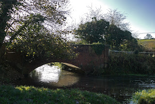
Further on we came to a nicely arched brick bridge. The sun was in the wrong place really, but it was a pleasing sight so I have done my best to salvage something with the aid of Photoshop Elements.
Now up the hill into Soberton. The first thing you see is Soberton Towers, designed and built by Colonel Charles Brome Bashford in the 19th century. Following Pevsner, it is impressive and picturesque at first, but disappointing on closer inspection.
The rather messy looking Norman-Gothic church of St Peter and Paul lies just around the corner. According to Pevsner there are some impressive wall paintings, but we did not stop to look inside.
There follows a quite steep climb up the other side of the Meon valley, reward as ever by fine views back. The church tower can be seen to the right.
The climb gave way to a grassy plateau where model aircraft enthusiasts ruled the skies. This gave way to a series of fields paths, past the red brick East Hoe Manor to descend into Hambledon through a beech hanger. A path at the back of the village brought us to the third church of the day, St Peter and Paul.
The church is of Saxon origin, but has been much altered and added to through the centuries. This marked the end of today's leg.
Hambledon is of course famous as the "cradle of cricket". The Hambledon Club was formed in about 1750 and played on Broadhalfpenny Down, a couple of miles to the east of the village. The famous Bat and Ball inn overlooks the down. Hambledon was apparently England's leading cricket club from about 1765 until the formation of the MCC in 1787.
Conditions: sunny and surprisingly warm.
Distance: 7 miles, so 57 now covered. The remaining 15 can be dealt with in two more linear goes, so the end is in sight and should be accomplished before the year is out.
Map: Explorer 119 (Meon Valley, Portsmouth, Gosport and Fareham).
Rating: three and half stars. Enjoyable and quite varied.


No comments:
Post a Comment