
Flushed with the thrill of Monday's impromptu start of walking the South West Coast Path, we decided to carry on. We parked at the Knoll Beach visitor centre and walked on down the sandy beach (Middle Beach) towards Redend Point, with Old Harry Rocks in sight beyond it.

When the beach ends, you climb a tarmac road and turn left into woodland. The views of the beach through the trees were delightful and - perhaps fancifully - reminded us of the Costa Brava, for example, a walk from Llafranc to Golfet.

Soon, we reached Fort Henry.

Soon, we reached Fort Henry.

It was built in 1943 and is 90ft long with concrete walls 3ft thick. In April 1944, it was the vantage point from which King George VI (now famous for his stammer of course), Winston Churchill, Lord Mountbatten, and Generals Montgomery and Eisenhower watched Operation Smash, a rehearsal for the D-Day landings which took place a couple of months later.
We then walked along Studland's South Beach and then took the path along to Old Harry Rocks at Handfast Point. This involved retracing - in reverse - the wonderful Studland to Old Harry walk we did last October - on which we took some nice photos of the Rocks.
We carried on towards Ballard Point, with a nice view behind us.

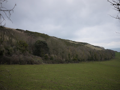
At Ballard Point we descended towards Swanage Bay - see the photo at the head of this post. At the outskirts of Swanage - New Swanage - the path heads inland through a housing development and at this point we followed a path back towards Ballard Down. This climbed steadily until it offered a lovely view of Ballard Down to the right, heading down towards Ballard Point, with the Isle of Wight faintly in view behind it.
Now we began steep, but mercifully diagonal, ascent of Ballard Down proper. After a short while a conveniently located bench offered magnificent views over Swanage. The Victorian pier, on the far side of the bay, was much more noticeable from this height.

We reached the ridge of Ballard Down at the point shown on the map as Stone Seat. Fair enough, there is an aged stone bench, complete with a graffito dated 1852.

We carried on the same direction and followed a path which descended to reach the Norman church of St Nicholas in Studland. We admired the fine chancel arches in the interior.

From here, we headed past the Old Manor Hotel to regain the Coast Path and retrace the last bit of the way to Knoll Beach.
Map: Explorer OL15 (Purbeck and South Dorset).
Conditions: cloudy, threat of rain.
Distance: 7 miles, of which 4 were on the Coast Path. Distance covered so far 6.5 miles.
Rating: Four stars.
Catkins on the way to Old Harry Rocks, Vinca in flower by a farmhouse on the way up to Ballard Down, snowdrops in St Nicholas church yard.
We carried on towards Ballard Point, with a nice view behind us.

At Ballard Point we descended towards Swanage Bay - see the photo at the head of this post. At the outskirts of Swanage - New Swanage - the path heads inland through a housing development and at this point we followed a path back towards Ballard Down. This climbed steadily until it offered a lovely view of Ballard Down to the right, heading down towards Ballard Point, with the Isle of Wight faintly in view behind it.

Now we began steep, but mercifully diagonal, ascent of Ballard Down proper. After a short while a conveniently located bench offered magnificent views over Swanage. The Victorian pier, on the far side of the bay, was much more noticeable from this height.

We reached the ridge of Ballard Down at the point shown on the map as Stone Seat. Fair enough, there is an aged stone bench, complete with a graffito dated 1852.

We carried on the same direction and followed a path which descended to reach the Norman church of St Nicholas in Studland. We admired the fine chancel arches in the interior.

From here, we headed past the Old Manor Hotel to regain the Coast Path and retrace the last bit of the way to Knoll Beach.
Map: Explorer OL15 (Purbeck and South Dorset).
Conditions: cloudy, threat of rain.
Distance: 7 miles, of which 4 were on the Coast Path. Distance covered so far 6.5 miles.
Rating: Four stars.
Sightings
A nice flock of Brent Geese off Middle Beach on the return leg.

Signs that winter is ending
A nice flock of Brent Geese off Middle Beach on the return leg.

Signs that winter is ending
Catkins on the way to Old Harry Rocks, Vinca in flower by a farmhouse on the way up to Ballard Down, snowdrops in St Nicholas church yard.
Reflections
It was great to be on Ballard Down again and be able to identify all the coastline back to South Haven Point. Of course you could study the map, but there is no better way to get to know an area than to extensively walk it.
It was also satisfying to do a walk without reference to a walk book. Our dependence on walk books is partly laziness and partly because I am still not very good at calculating distances. Still, our planned approach to the Coast Path will require more of this, which is excellent.
No comments:
Post a Comment