
Chepstow Castle
I stopped off at Chepstow on the way back from a visit to my daughter and collected the Heritage Trail map from the Tourist Office near the castle. Chepstow has a distinctive situation, lying inside a meander of the River Wye. I started by walking down to Old Wye Bridge over the river to see if it offered a view of the castle, which is on a long ridge rising away from the river.
There was a view from the but it was into the sun, so I contented myself with a picture of the river which highlights the surprising limestone cliffs on the opposite bank. The bridge you can see carries the busy A48 road. It was also clear that the Wye is still tidal at this point and is apparently notable for its very high rise and fall, a staggering range of 12m or 40ft.

A short tour of the impressive castle followed. Pevsner describes it as "one of the most exhilerating and instructive castles in the whole of Britain". It is surprisingly big, with several discrete sections stretching along the ridge. The Norman keep dates from 1067-75 and it was extended in two phases up to 1300. Further changes were made in the Tudor and Civil War periods. This is the lower bailey with the end of the keep beyond. The river can be seen in the background.

Beyond the keep lies the upper bailey and the barbican and this is the view back towards the Old Wye Bridge, currently being restored, from there. It dates only from 1816 and the upper part is made of cast iron. The centre of the bridge marks the boundary between England and Wales.

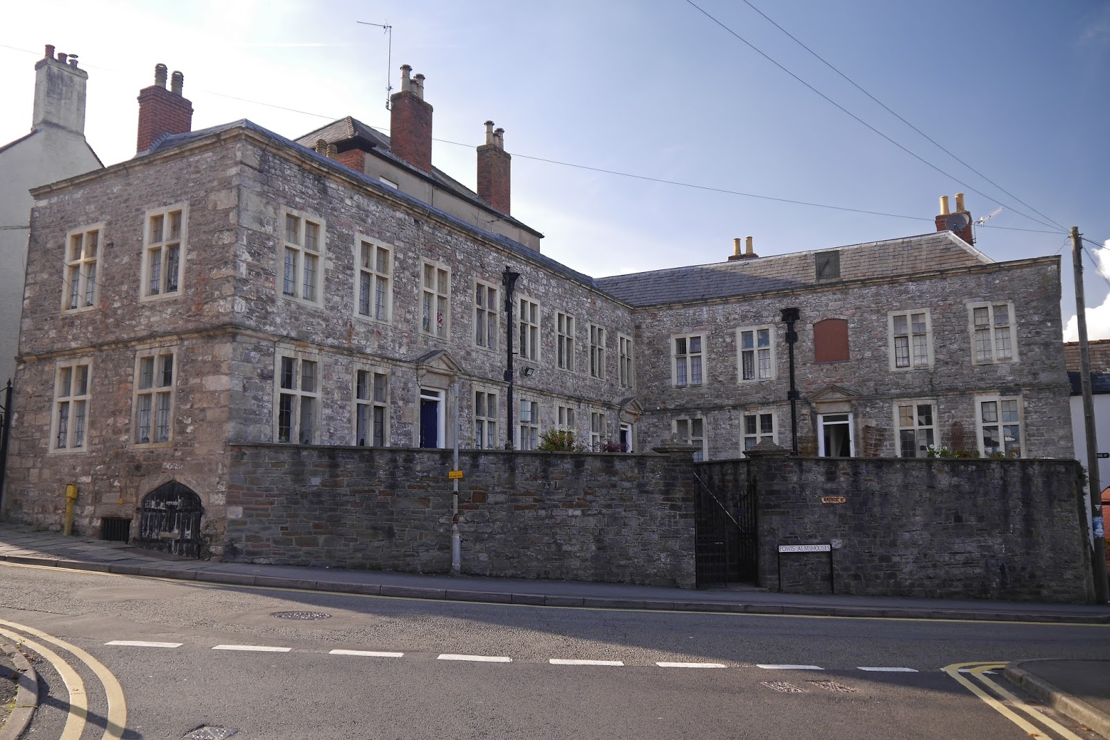
The town follows the line of the ridge as well and from the castle I walked up Bridge St. At the top on the right are the Thomas Powis almshouses of 1716. Pevsner describes them, in a way which is a bit patronising, as "a delightfully artless and unspoilt ensemble".
I continued on the same line along cobbled Hocker Hall St and Bank St to bear right and spot a section of the Port Wall near the public library. The meander of the river forms a U shape and this wall, built around 1272-8 as part of strengthening the castle, originally closed off the landward side. It is now much reduced and slightly sad looking.

I emerged onto Welsh St and headed uphill in search of a vantage point over the castle, but without success and so returned to the bottom of that street to find the Town Gate.

This was once the sole entrance through the Port Wall is said to have been rebuilt in 1524. I went through it and walked down the steep High St back towards the river, then into St Mary St and right into Lower Church St. Here there are a second, more picturesque, set of almshouses, those of Sir Walter Montague of 1614. Pevsner thinks the barge boards and drip mouldings over the windows are 19th century additions.

At the bottom of this street is St Mary's Priory church, founded 1067-71. The west end has a fine tower with an extravagant Norman doorway, but the transept (just visible on the right) and east end are in a very discordant Victorian gothic.

Immediately on the left as you go inside is the fantastic mid-Elizabethan tomb of the second Earl of Worcester and his second wife. The bright colours and reasonably lifelike figures are very arresting.

To complete my walk, I wandered along to the A48 bridge and took the picture of the castle at the head of this post. It doesn't do justice to it, but was the best I could manage. I returned to the castle car park by going past the church and skirting the former docks area by the river, now being redeveloped (although it looked as though work was currently suspended).
Conditions: quite warm and sunny.
Distance: 3 miles or so.
Rating: four stars.
No comments:
Post a Comment