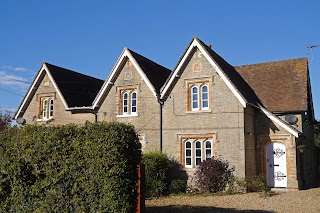
Merley Hall Farm
We decided to take advantage of the forecast fine day to continue the Stour Valley Path from where we left it in Willett Road. We got off to a promising start, immediately spotting a late Small Tortoisehell.
We quickly passed Merley Hall Farm House, an interesting building which seems to consist of three distinct parts stuck together. The middle section has this delightful statue in a niche under a Dutch gable. A little further along there is a nice pair of Lady Wimborne houses - we saw a lot of her works in the previous leg.
At the end we crossed the A31 and followed a path across Eye Meadow towards Eye Bridge. We were impressed by this new squeeze stile - it would be quite a squeeze for anyone carrying much surplus weight.
At Eye Bridge the river was very calm. Just beyond the weir, you can see where there is a ford. probably too much water in the river today however.
Our guide book offers a choice here: follow the road, Cowgrove Road, or follow the river. We naturally took the latter, longer and muddier thought it was. After following a pleasant meandering path by the river, and spotting a Small Egret, we forked northwards to cross the road at the well-named Poplar Farm.
A bridle path led on pass the wonderfully named All Fools Lane (we were glad we didn't take it) and join a road which brought us to the back of Kingston Lacy House. Just before we got there, a farm on the left offered a new model of farming: hay bales, some sort of cabbagey crop and cows all in the same field. The cows did look a bit guilty though.
The wide drove behind Kingston Lacy was wonderful - and produced a second butterfly, a Red Admiral.
Following a suggestion from our guide book, we ignored a Stour Valley Way sign on the left and instead took the next left into Sweetbriar Drive. This was a fine wide track with some lovely mature beech trees.
Towards the end there was a view of Badbury Rings to the north.
While to the left, on the ridge on the far side of the Stour Valley is the folly tower of Charborough Park. Sweetbriar Drive continues ahead into Park Lane which leads down into Shapwick. Here we saw several houses with wonderfully ornate window heads.
At the end of the very rural looking High St we stopped for refreshments at the excellent Anchor pub - and resolved to come back for a meal. We also had a quick look at the church of St Bartholomew.
We found it very picturesque. The tower and nave are 14th century and there are some Norman elements too.
We left the village and walked across field paths to get gradually nearer to the river again, finally emerging a short distance from Crawford Bridge, on the outskirts of Spetisbury, where we had left our car. I took this picture from the opposite bank in the morning and it profits from the morning light. Just as well as it was gloomy and quite cold when we returned there.
Pevsner reveals that this south side of the bridge dates from 1819 (the 1719 date stone which can be seen was re-set). The other side is medieval and has the traditional bays of a pack bridge over the piers where pedestrians can still get out of the way of wheeled traffic.
Conditions: reasonably warm and sunny until mid afternoon.
Distance: 6.75 miles. Total now covered 25.5 miles.
Guide: The new Stour Valley Path by Edward R Griffiths, Greenfiled Books, 1998, but sadly out of print.
Map: Explorer 118 (Shaftesbury and Cranfield Chase).
Rating: four stars. Thoroughly enjoyable and quite varied.


No comments:
Post a Comment