Tuesday, 21 April 2015

Girona art nouveau

A window in the Casa Masó

The historic city of Girona also turns out to have a rich heritage of art nouveau buildings, especially by Raphael Masó (1880-1935).  In Catalonia this architectural style is known as Modernisme (not to be confused with the postwar vogue for Modernism) or Noucentisme. It was influenced of course by Gaudi, that most individualistic or architects, but has many common elements with the wider art nouveau movement elsewhere in Europe. Masó's career extended into the 1920s and 30s, so not all his work can usefully be seen as art nouveau. I found this walk hidden away on the website of the Masó Foundation: here is the link.

The official walk starts, reasonably enough, from the Casa Masó, converted by the architect into his family home in 1912, but coming from our hotel on the left bank of the Onyar we first encountered the Bloc Cots on Carrer de Santa Anna, which dates from the 1920s, and is obviously not art nouveau. The decorated panels and the ceramic tiles under the overhanging roof turn out to be typical of Masó's later style.


Next door, however, was a much more art nouveau building with floral motifs over the windows and used as capitals on the columns which separate the windows.


We now crossed the bridge across the Onyar and noted the river frontage of the Casa Masó, the white building in the centre of the picture. The exterior blinds dominate the view, but the ochre coloured tiles are a delight.


Immediately on crossing the bridge, the Pharmacia Masó-Puig is found on the left. You enter through the original pharmacy - a conversion for Rafael's brother Joan, who was a pharmacist - and notice to the left a modern chemist's shop. The facade has been altered since the conversion in 1908, but the old pharmacy has a wealth of original wrought iron shelves, ceramic tiles and light fittings, like the one below.


The Casa Masó is round the corner in Carrer Bellesteries. You only visit on a pre-booked tour. We were lucky enough to find one in French starting within 20 minutes. It was originally four workers' houses which Masó converted into a single dwelling on the occasion of his marriage in 1912. These are some of the wonderful tiles in the entrance hall. We learned from our guide that each one has some family significance.


The first floor hall is especially impressive. The glass in the doors to left is pure art nouveau, while the area to the right seems to show a debt to Charles Rennie Mackinosh. The house was an absolute delight, with beautiful glass, tiles and decorations throughout.


We looked next at another Masó building, te Bloc Ribas Crehuet in Carrer de la Forca, nearby. This five storey building of 1927-8 had to be fitted into a gap between older buildings and did not allow much scope for architectural exuberance. There was another decorative panel as the main ornamentation.

We now headed along the Rambla de la Libertat where I had spotted this marvellous building: the Casa Norat of 1912-13. It was the work of Joan Roca i Pinet. The ground floor curves and oriel window are just fantastic.


Almost opposite was this building with beautiful green nouveau-style decoration.


Returning to the Masó trail, we came to Bloc Salleti (1914-15) in Carrer de al Neu. This was a block of apartments for rent. Tiles are used as the main decorative element: plain straw coloured ones alternate with spiral-decorated "nipple" ones to produce a pleasing and original effect. I wish now I had taken a close up!


Now we crossed the river and walked along Carrer de Neu to find the Casa Battlle on a corner on the left. The lower part of the building is much altered, but the upper part retains powerful ceramic decoration featuring stylised yellow owls. The walk booklet suggests that Masó was influenced in this choice by the Austrian Secession. We saw the Secession building in a walk around Vienna a couple of years ago and there is a definite resemblance.


Crossing Grab Via Jaume 1 you come to the Placa del Marques de Camps and the Casa de Corominas of 1927-8. This was another alteration to an existing building. The stained glass and green floral decoration seemed to be quite art nouveau in feeling, despite the late date.


Nearby is the Casa Gispert Sauch of 1921-3, of no clear style but only blue tiles and an unusual corner balcony.


At this point we had, sadly, run out of time and did not get to see Masó's most celebrated building, the extraordinary Farinera Teixidor (It is a flour mill, although you would never guess.) You can see a picture on Spanish Wikipedia.

Conditions: hot and sunny.

Distance: a couple of miles, including the return leg.

Rating: four stars. The Museum was a delight and some of Masó's buildings are impressive. My favourite however was the Casa Norat.

Monday, 20 April 2015

Girona

 Girona Cathedral and the river Onyar

We have just arrived in Girona en route to stay with our friend Maggie in Llafranc on the coast. There is just time today for a late afternoon stroll to see something of the old town, especially the walls. We set off from our hotel and cross the river Onyar. The tall houses which line the river are a delight and the Cathedral looms on its hill beyond.

We walk along the Rambla de la Libertadad to emerge beside the river and talk a left to reach the start of the walls. You climb some steps and then begin to follow a narrow walkway. The corner turret looks pretty, but had obviously been recently used as a toilet.


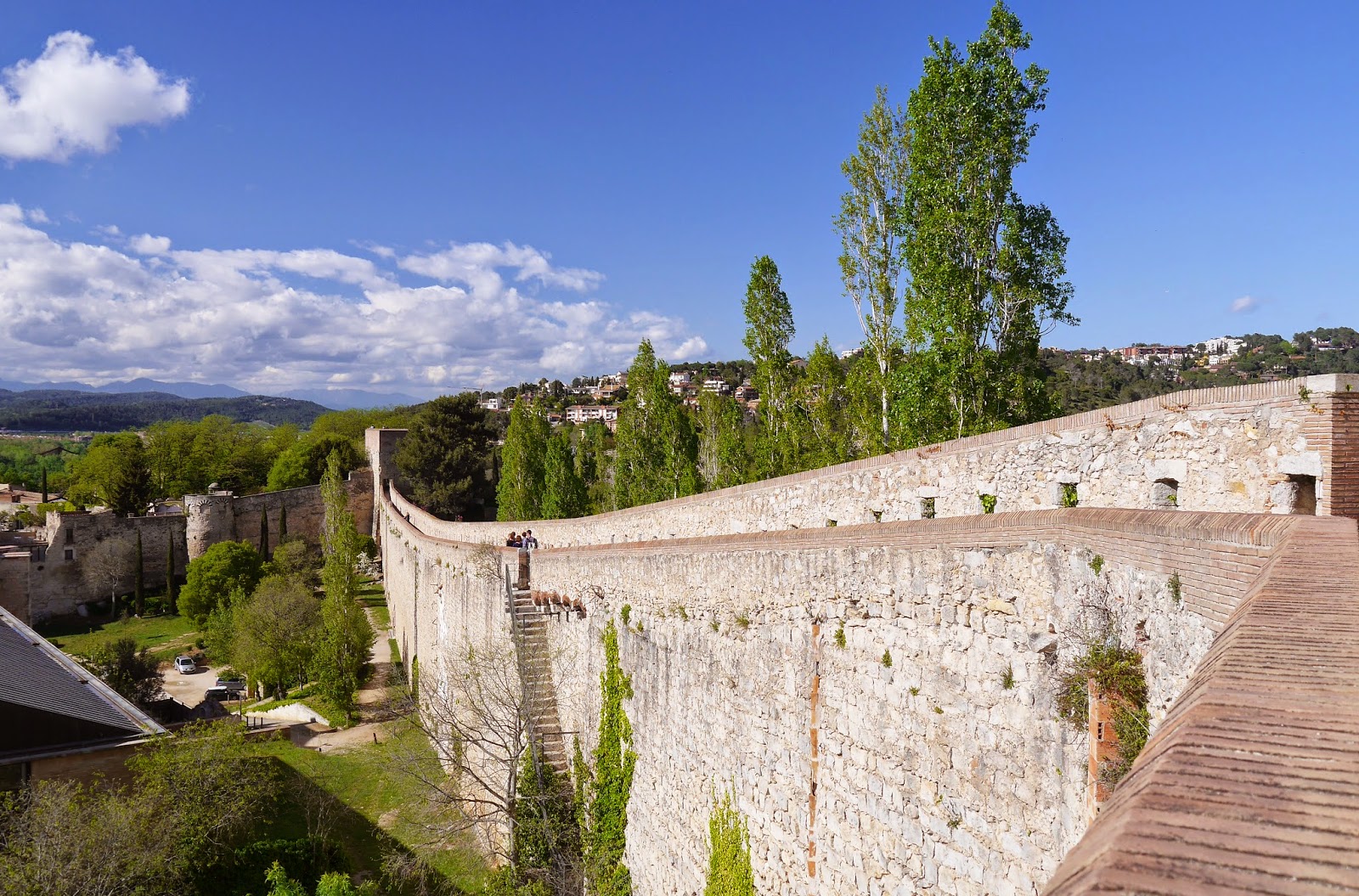
 It was very instructive to see how Girona is surrounded by mountains and this was especially clear from the top of the next bastion, with the church of Sant Feliu (further away) and the cathedral on the right.


From the next tower, the narrow walkway stretched ahead towards the north.


Further on we noticed a wonderful green house facade down to the left. 

The wall continued to the north east corner where some sections had decorative arches. 


On this corner the pretty Jardins d'Alemanys (German garden) offered a shady spot to avoid the summer heat. We now left the wall and wandered round the side of the Cathedral to the main facade at the head of an impressive stairway.


The Cathedral is of 11th century origin and was altered in the 14th and 15th centuries and now has the widest Gothic nave in the world. The massive west front has a baroque facade, dated 1753, superimposed on it.

Round the corner is the church of San Feliu, which was constructed between the 13th and 17th centuries. It is unusual in Spain in having a spire. The stump opposite the left hand tower is simply because the tower was never built. Like the Cathedral, the baroque facade is rather incongruous.


We then crossed the river again, admiring the reflections of the riverside houses in the river, which by now had more water in it.


We concluded the walk with an aperitif in a square near our hotel.

Conditions: sunny and warm.

Distance: about two miles.

Rating: Four stars. There is of course lots more to see.

Friday, 17 April 2015

Black Down to Marley Common (Serpent Trail 2)

Black Down

We started the Serpent Trail with Viv and Giles last December, but it has taken a while to return to it. We resumed at the car park near Balck Down and walked through woodland to emerge onto open heathland.

To the right there were nice views to the east.'


We last walked in this area in July 2014, starting out from Fernhurst. On that occasion we failed to locate the evocative-sounding Temple of the Winds. We were hampered by our belief that it was something resembling a temple, we had the idea that there was maybe a circle of stones or something similar.

As we were heading along the path we met another group of walkers who enquired if we knew where the Temple of teh Winds was - they had seen signposts, but couldn't find it. We made sympathetic noises. This time we did locate the Temple, not without some difficulty - even when close up it was somehow hidden. It turns out to be a belvedere just below the edge of the hillside with a wonderful view to the south.


This is at the southernmost point of Black Down and we headed away to the north to soon overtake the other walkers who had stopped for a break. They were very gracious when they received the news that we had located the elusive Temple.

Further on we started to see the distinctive cattle, Belted Galloways, that the National Trust uses to graze the heathland. They are certainly well-named.


We continued along a broad path across the heath and then headed along the base of a grassy hillside, with a ridge ahead of us revealing scattered substantial houses.

Somewhere around here we missed our way and found ourselves walking along a lane with confusing signs to Valewood Farm House and Valewood House. We couldn't quite work out where we had gone wrong - or indeed where we were. After some trial and error behaviour we eventually worked out that we had been going in the right direction but were on the wrong side of a small stream.

Somewhat chastened,  made our way to the A286, Bell Road, and crossed it to walk through the woods of Marley Common to reach where we had parked.

Conditions: bright and mild.

Distance: 4.8 miles. Distance now covered 7.3 miles. We hope to increase our pace next time.

Map: Explorer 133 (Haslemere and Petersfield).

Rating: four stars.

Monday, 13 April 2015

Gramps Hill to Ashbury Folly (The Ridgeway 10)

Uffington Castle

We have planned a once-a-month programme to finish the Ridgeway. Today's walk starts under rather dull, grey skies. We start with a brief look at St Michael's church in Letcombe Bassett, where Gramps Lane, our point of resumption, begins. The chancel is Norman and we wondered about the unusual external rendering. The churchyard had a wonderful display of primroses and other flowers.


At the point where Gramps Lane intersects the Ridgeway, the countryside stretches away to the west. You couldn't really see it when we started, so I have used this picture, taken when we returned to collect out car after the end of the walk


The path is chalky - thank goodness it was not wet or it would have been very slippery - and the fields to the north are a mass of chalk as well. By the side of the path we saw a couple of isolated Cowslips, just beginning to come into bloom.


At one point further on, I was admiring further scattered yellow blooms in the adjacent fields and thinking how pretty they looked. Of course it was only early-ripening Rape, but the effect was charming and much more gentle than the almost fluorescent yellow we will see next month.


Eventually we reached the back of Whitehorse Hill, which peaks at 261m. We headed across the grass away from the track to investigate Uffington Castle. The first impression is of the substantial ramparts and, once you clear them, of the great scale of the iron age (300 BC to 43 AD) hill fort they enclose. We were amused to see a sign that revealed that the fort was in the care of the Ministry of Works (it must have been there since before 1962 when that body was renamed).


We have seen quite a lot of these in southern England and Uffington must be one of the largest. A different view of its scale comes from the view at the head of this post, taken from the road immediately below the hill after the end of the walk.

We walked to the edge of the plateau and gained a great view of the country below towards Uffington village. In the foreground, a lovely combe known as the Manger.


This is what it looks like from nearer ground level.


To the right of the Manger is the rather artificial-looking Dragon Hill. We speculated that maybe it was formed by scourings from the nearby White Horse, but I learn from Wikipedia that it is a natural chalk hill. It has a legend attached to it that it was where St George slew the Dragon (hence the name!) and the bare patch of chalk visible in the photo, where apparently nothing will grow, is supposedly where the Dragon died.


On the way back I climbed Dragon Hill expecting to get a good view of the famous White Horse, which was apparently dug in the first century AD, but unfortunately the view point, although interesting, was too low.


Continuing now along a rolled path we soon reached Wayland's Smithy, a Neolithic Long Barrow, dating from the 4th century BC. But what has that got to do with Wayland? According to English Heritage, "it was once believed to have been the habitation of the Saxon smith-god Wayland". Wikipedia adds that this usage dates from 955 AD.


Another mile brought us to the car park at th einterestingly names Ashbury Folly, just up the road from the village of Ashbury where had lunch in the excellent Rose and Crown. I can't find any trace of an Ashbury Folly, but googling has revealed that there is a Folly Tower at Faringdon, about seven miles away, which looks worth a visit.

Conditions: Grey at first, brightening later.

Distance: 6.8 miles. Distance now covered 66.4 out of 86.8 miles.

Map: Explorer 170 (Abingdon, Wantage and Vale of White Horse).

Rating: four stars. Uffington Castle and White Horse were just wonderful.

Tuesday, 31 March 2015

Midhurst

The ruins of Cowdray

Today a "town and country" walk starting in Midhurst with my friend Merv. We parked in North St on the northern edge of the town and headed across the main road, past the former Grammar School, to the new South Downs Visitor Centre where we were delighted to find the excellent Town Trail leaflet. I immediately went just a little further up North St to photograph Ognell's Almshouses. The twin plaques reveal that they were erected in 1578 and rebuilt in 1840.


We made a loop around Lambert's Lane a rejoined North Street nearer the town centre, noticing some fine Georgian buildings such as the Clock House.


Some apparently Georgian buildings were in fact medieval ones which had been refronted, sometimes quite blatently. We saw one with a Georgian facade on the main street and half-timbering along the side.

A bit further on we saw this wonderful art deco shop front. I couldn't take the whole of it because a large white van pulled up as we were approaching.


We walked along the charming Duck Lane to find the other, unnamed, Almshouses in Bepton Road. They were originally 16th century, but were rebuilt in 1832.

Turning now into West Street, we enjoyed a lovely street scene with timber-clad and timber-framed houses.


On the right a mysterious plaque announced that "In 1811 The Commandery House of the Knights of St John stood here". We collected a leaflet about this is the Midhurst Museum, of which more in a moment. Apparently, the Knights of the Hospital of St John the Baptist at Jerusalem, to give them their full name, held property in Midhurst and had a chapel there. The Knights were suppressed by Henry VIII in 1540 and their lands were seized, the chapel later being demolished. The plaque and the doorway in which is located, were erected in 1811 by John Seymour, local antiquarian, but there is apparently no evidence of the existence of a Commandery.

At the end of West St we turned right into South St and looked back on a lovely view with the Spread Eagel Hotel on the left. The tower of St Mary Magdalen and St Denys can be seen to the right. It is of 13th century origin but has been subject to "too much restoration" (Pevsner). It is certainly rather  a jumble of disparate elements.


The Market Square stands in front of the church and on the right is the Old Market Hall dating back to 1571. "Indifferent" says Pevsner and it is not hard to agree.


We followed Church Hill into Knockhundred Row, admiring a mixture of half-timbered and Georgian buildings. The town Museum already mentioned is in Knockhundred Market and is a remarkably small one: a single room 8ft 6in square. A very helpful volunteer explained that the collection changes every week.

We were now nearly at the end of our town walk and I must just mention one other impression: we saw several houses with their woodwork painted a rather virulent shade of dark yellow and we spent some time trying to conjure explanations for this. Maybe somebody had bought too much and sold it off cheap to his friends? The house in the background on the right above is an example.

Now up Sheep Lane past St Ann's, the largest of the many Georgian houses and along a narrow lane to suddenly emerge in the country, at the bottom of St Ann's Hill.

This quiet wooded hill is now all that remains of the Norman castle built here not long after the Conquest. We walked round it and then down to follow a path by the River Rother which soon led us to the magnificent ruins of Cowdray. This view taken on an angle gives more a sense of the large scale of the house and a glimpse of the ruins of the chapel.


The house was started in 1492 and bought by Sir William FitzWilliam, later Earl of Southampton, in 1537. It was he who added the magnificent gatehouse. His half-brother, Sir Anthony Browne, took over in 1542 and made further additions. The house was sadly destroyed by fire in 1793. Pevsner adds that eight days later the last of the family was killed trying to shoot the Rhine Falls; this fulfilled a curse (Pevsner does not say by whom or why).

We followed a wide path to nearby Easebourne, once the site of an important Priory, now a house attached to the church. "A picturesque ramble" says Pevsner.


We were soon confronted by more dark yellow woodwork. This building is the (Cowdray) Estate Office and it finally dawned on us that the ubiquitous dark yellow is the Cowdray colour. 


After a very good pub lunch we headed on through the village and turned right to walk through teh outskirts of Cowdray Park. After passing Vining Farm, there was a pleasing view south towards the South Downs.


Soon after this there was great excitement as we saw our first butterfly of the year, a Comma.


This was quickly followed by a Small Heath as we walked through classic country house parkland - landscaped, inevitably, by Capability Brown. Then across the golf course, the A272 road and beside the massive Polo field to return to Easebourne and thence past Cowdray again and back to the car park.

Conditions: sunny, but very windy.

Distance: about 6.5 miles.

Map: Explorer 133 (Haslemere & Petersfield).

Rating: four stars. A delightful small town with a wonderful ruined castle nearby.