Pages

Thursday, 29 July 2021

Frome and Nunney Castle

                                                                    The Round Tower

Merv and I started our exploration of Frome at the Black Swan Arts Centre where we acquired a map. The Round Tower was built as a wool-drying stove in the 18th century and is a reminder of Frome's cloth industry. It is now the start of the town trail. Opposite, where the cattle market was, is the Market Hall, now a pub.

We crossed the bridge over the River Froom (1667) to reach the handsome Blue House. It was built as an almshouse around 1465 and rebuilt to include a school in 1724. The pupils wore blue uniforms which gave the building its name. It now houses flats for retired people. It was a shame that building works are underway.


We walked up the narrow Market Place and turned left into medieval Cheap St where an ancient leat (an open water course) channels water.

We then approached St John the Baptist's Church by following a path parallel to its wonderful Via Crucis (the Way of the Cross).


My photo of the church was taken from the rear, but one taken from the road (Bath St) would have been preferable. The first (saxon) church founded by St Aldhelm in 685AD and replaced by a Norman structure of the late C12 which was gradually extension until reaching the present footprint around 1420. It was largely rebuilt in the 19th century.

We walked down to Bath Street to see the very grand Rook Lane Congregational Chapel of 1707. It was so grand that many Chapel members found it offensive.

We returned past the church and turned right into Gentle Street, where two fine houses could be found on the right hand side: Argyll House of 1766 and 19th century Argyll Lodge.

We continued along the lane passing the massive former Lamb Brewery.


We turned right at the top passing Wesley Villas on the left, a complex of 19th century buildings, to reach the modest Town Hall.

Now left into Wine Street which led us to a delightful little street, Sheppards Barton, which was developed by the Sheppards to provide workshops and houses for cloth weavers. At the end of the street steps lead down into Catherine Hill.

This is the view downhill (back towards the Market Place).

We turned left and passed this curious lovers' post box and the Valentine Lamp, installed in 1993, inevitably on Valentines Day.

At the top end of Catherine St we turned right along Vallis Way which leads into the Trinity area. Our guide book explains that this area was one of the earliest developments of industrial housing in Europe. At the end of Trinity St we admired Trinity Church (1838). Only once I got home did I spot that the church contains stained glass windows designed by Burne-Jones and made by Morris and Co.

We turned right down Trinity St to pass the monumental Butler & Tanners Steam Printing Works.

We continued down hill via Trinity St, Castle St, Milk St and Cork St to return to the start of the walk.

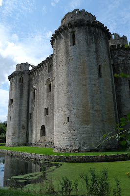
To add extra spice to our walk we headed off to nearby Nunney, where a picturesque medieval castle, Nunney Castle, waited for us. It dates from the 1370 and its builder was Sir John de la Mare, a local knight who was beginning to enjoy royal favour. Much modernised in the late 16th century, the castle was besieged and damaged by the Parliamentarians in 1645, during the English Civil War.

This is the first view you get of the castle: you can deduce that it is rectangular with huge circular towers in each corner.

Once you get inside the enclosure it becomes clear that the Castle is surrounded by a moat. It  is pretty battered, but has a very impressive presence.

Conditions: bright and sunny.

Rating: four stars.

Saturday, 17 July 2021

Stanton Fitzwarren, Hannington & Broad Blunsdon

We started this walk at the village of Stanton Fitzwarren, not far from Swindon on the north east tip of Wiltshire. We parked in slightly the wrong place but as we walked down the road we did get to see this wonderful piece of thatching.

We left the village street and walked across grassland and then a field-edge path to reach Staples Farm. We crossed the road and walked along a grassy green lane with numerous butterflies, Meadow Browns and Ringlets especially.

The walk took us to the eastern side of Hannington and offered a fine rural vista as we got closer.

We emerged into Hannington close to Hannington House. According to Pevsner it dates from 1653. The building on the left bears the inscription Henricus Breke CB 1836, presumably a former owner.

We walked into the village passing what looks like a former chapel on the right ...

... and soon reached the delightful Jolly Tar pub. We found we just had to pause for a glass of beer. We would perhaps have had lunch as well except that it was fully booked.

We headed along the main street and took path to the left and then followed a series of paths heading south west. We passed Lower Burytown Farm and were very taken by the large yew drums in its garden.

We climbed steadily to enjoy fine views to the north ...

... and then to reach Castle Hill, a typical iron age hill fort.

The final section was disappointing. We continued along a lane to turn south east at the cemetery and cross fields to reach a quite busy road. We walked along the narrow verge and turned right past a farm and then were directed to go through a gate and continue in the same direction across several fields to reach Mill Lane and then Stanton Fitzwarren. We succeeded in accomplishing this, but the odd sign post would have helped.

From: 100 walks in Wiltshire.

Distance: 5.5 miles.

Map: Explorer 169 (Cirencester & Swindon).

Rating: 3 stars.

Thursday, 8 July 2021

Blenheim Palace

                                                          The approach to the Palace

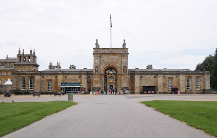
We first visited Blenheim (and Woodstock) last November and thoroughly enjoyed it, even though the interior was closed at the time and the weather was quite grey. The visit of a friend from the US gave us an opportunity for another look. We walked up from the car park to the imposing main entrance gate, the East Gate.


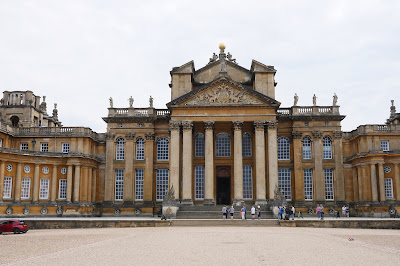
This leads into a large courtyard which in turn give way to the Great Court, in front of the Great Hall.

After a short wait we went through the main door to discover just how high the Hall is. Looking through the doorway, you can see the Column of Victory (1727-30) in the distance.

We followed the interior route which featured a number of clothing designs by Osbert Sitwell - not really my thing. But near the end of the route we emerged into the astonishingly vast Library, now sometimes available for social events.

Leaving the Hall we came upon the Chapel, a small rather awkwardly shaped building designed by Sir John Vanbrugh as a memorial of the First Duke of Blenheim, commissioned by his wife. The chapel was not finished when the duke died in 1722, so he was buried in Westminster Abbey, but was reinterred in the crypt underneath the chapel alongside his wife after her death in 1744.

We now went round the side of the Palace buildings to visit the formal gardens. If you are alert you can spot a couple having a photo shoot.

There was no way of exiting the Palace other than retracing our steps, but this did give us a fine view of the buildings to the left of the Hall in beautiful sunshine.

We exited via the East Gate and walked around the side to at last see the range of buildings in their full splendour.

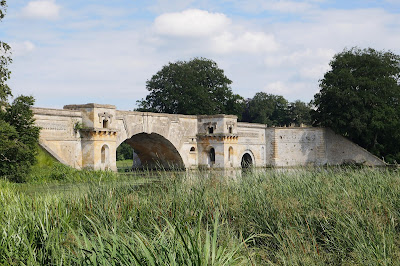
We walked away from the Palace down to the see Vanbrugh's magnificent Palladian style bridge, which separate the two parts of the lake.

It was interesting to find an area left aside for butterflies and we were delighted to spot a few we hadn't seen so far this year (Marbled White, Ringlet, Meadow Brown, Gatekeeper). Finally, there was a lovely view including both the bridge and the Palace.

Another discovery, when writing this, was that Blenheim is a World Heritage Site.