Old Brewery Hall, Ansty
Seduced by the prospect of "balmy" weather, we set out late for this walk in rural Dorset. The route begins at the Old Brewery Hall (the village hall) in Ansty, which today was hosting a children's party. This was the original brewery of Hall and Woodhouse who began their trade in 1777 and now of course operate from Blandford Forum. Malthouse Cottages stand at right angles as a further reminder of local history.
You head west beside and then across fields to reach Melcombe Park Farm. There is a nice view across to the right of the ridge which extends south from Bulbarow Hill.
From here a path along a hillside and then a ridge leads towards the Dorset Gap. This is the view towards Higher Melcombe Farm from the ridge.
We wondered what the Dorset (or Dorsetshire) Gap could be. It turned out to be the intersection of five ancient tracks. According to Wikipedia, "The Gap was an important road crossing from the Middle Ages until the 19th century, linking the trails of the (Wessex) Ridgeway with the drove roads to the north".
You take one of the tracks down a steep cutting towards Higher Melcombe. On the sides of the cutting we were pleased to see the first wild primroses of the year. Soon you are walking beside fields which once contained the village of Melcombe Horsey, which disappeared after the Black Death. Higher Melcombe itself now consists of a single farm, whose 15th century manor house, built for Sir John Horsey, has a later chapel. I spotted the chapel as we passed, but only discovered the rest of the story when I read the walk book later.
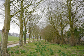
Soon you join a road with a lovely avenue of trees just beside it ...
... and follow it into Melcombe Bingham, where you turn right by this rather splendid modern thatched house.
The path leads across fields to reach Bingham's Melcombe (a shade confusing, no?). This is the country house of the Bingham family. Pevsner describes it as "a completely irregular courtyard house of many dates from c1500". You can't see it, apart from the small Dower House, but the 14th parish church is accessible - just to add to the confusion, the parish is called Melcombe Horsey.
You now partially retrace your steps and follow a path across fields back to Ansty.
Conditions: bright at first, but becoming increasingly grey as the day wore on.
Distance: 5 miles.
Map: Explorer 117 (Cerne Abbas & Bere Regis).
FRom: 50 walks in Dorset (AA).
Rating: three and a half stars.


No comments:
Post a Comment