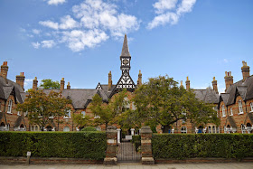
Elison House (The Windsor Almshouses)
A short, fairly local, walk today around Windsor and Eton. I noticed it in a walk book the other day and it offered me the opportunity to see the Windsor Almshouses. I parked in Victoria St, where the almshouses are, and started the walk from there.
The almshouses, now called Ellison House, were built in 1862, but I have been unable to find anything more about them. The photograph on the invaluable Images of England website (English Heritage's photo library of listed buildings) totally fails to do justice to the beautiful brickwork.
Nearby is Charriott's Place of 1863, which Images of England says formerly had a row of almshouses attached. It is an extravagant and picturesque construction.
After this, I set off towards the river for the official start of the walk, first passing in Town Hall (or Guildhall) in the High St. It was designed in 1687 by Sir Thomas Fitch and construction was supervised by Wren after Fitch's death. Next door is the delightful Crooked House.
Continuing along High St, Castle St on the right offers an impressive view of the Castle. It is remarkable just how big it is. It is of course England's largest castle and covers about 13 acres. It was founded in 1165, but most of what you see today is 19th century.
The massive walls and towers that form one side of Thames St are however from Henry III's reign (1216-1272).
I reached the footbridge across the Thames that leads to Eton and turned right following the Thames Path out of the town centre and along the edge of the Home Park enjoying more views of the castle.
You cross the river at a road bridge and double back on the other side, initially through a golf course (ugh!). There was a funny moment on emerging from the golf course when the instructions in the walk book completely failed to match what was there is front of my: specifically, there was a river where the book described rough meadowland. Walk books do become out of date of course and you expect minor changes and perhaps the odd new housing development, but a new river seemed a bit much. After a moment I realised that it was the Jubilee River, a flood defence scheme and on checking discovered that the book pre-dated the Jubilee by some years.
Thus reassured I found my way to the playing fields of Eton and then the road into the small town, where I enjoyed this view of the school and its chapel. Eton College was founded in 1440.
The school is massive, as a result of its 19th century expansion, and very reminiscent of Oxford or Cambridge. I hadn't previously realised that the chapel is contemporary with St George's Chapel in Windsor Castle and the chapel of King's College Cambridge (i.e. mid 15th century).
As you emerge from the College buildings you enter the attractive High St and I was delighted to discover, right at the end, the Christopher Hotel with its wonderful tiled art nouveau facade. The left hand section had shamefully been over painted.
Conditions: mainly cloudy with some sunshine especially at the end.
Distance: a bit over four miles from my starting point.
From: Chilterns and Thames Valley Walks (Pathfinder Guides). The full walk extends to Eton Wick and back along the river from there, 5.5 miles in total.
Map: Explorer 160 (Windsor, Weybridge and Bracknell).
Rating: four stars. There are lots of interesting things to see in Windsor and in Eton, but the walk along the river and back along the other side was extremely dull for the most part.


No comments:
Post a Comment